SOILS OF INDIA
Soil: The Foundation of Terrestrial Life
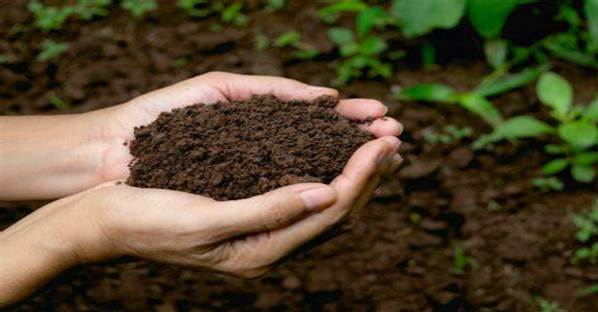
Soil, a dynamic and living system, is the amalgamation of rock debris, organic matter, air, and water, forming the uppermost layer of Earth’s crust. Its formation is a slow and complex process, evolving over millennia through the interactions of various physical, chemical, and biological factors. Soil plays a critical role in supporting terrestrial life, acting as the primary medium for plant growth, water filtration, and a repository of nutrients.
Soil Characteristics
- The characteristics of soil are shaped by its origin, composition, and environmental factors, making each soil type unique. These characteristics determine the soil’s agricultural potential, ecological function, and use in human activities.
Texture
- Soil texture refers to the relative proportion of different-sized mineral particles it contains, namely sand, silt, and clay. This composition affects the soil’s water retention capacity, aeration, and workability. For instance, sandy soils, with their large particles, have high permeability but low water retention, making them less fertile than loamy soils, which have a balanced mix of sand, silt, and clay, offering optimal conditions for plant growth.
Fertility
- Soil fertility is a measure of its ability to supply nutrients to plants. It is influenced by the soil’s organic matter content, texture, and structure. High fertility means the soil contains adequate nutrients and has the capacity to sustain agricultural productivity. Organic matter plays a pivotal role in enhancing soil fertility by improving nutrient availability, water retention, and soil structure.
pH Level
- The pH level of soil is a critical factor determining its acidity or alkalinity, which affects nutrient availability and microbial activity. Soil pH ranges from acidic (<7) to neutral (7) to alkaline (>7). Most crops thrive in slightly acidic to neutral soils, as extreme pH levels can limit nutrient uptake and inhibit plant growth.
Permeability
- Soil permeability is its ability to transmit water and air. It depends on the soil’s texture, structure, and organic matter content. Permeable soils facilitate good drainage and aeration, essential for root health and microbial activities. Conversely, impermeable soils, such as those high in clay, can lead to waterlogging and poor aeration, adversely affecting plant growth.
Porosity
- Soil porosity refers to the volume of pore spaces within the soil, which determines its ability to hold air and water. Porosity is influenced by soil texture and structure; well-aggregated soils with a mix of particle sizes tend to have higher porosity. This property is crucial for water infiltration, root penetration, and gas exchange between the soil and atmosphere.
Salinity
- Soil salinity is the concentration of soluble salts in the soil, which can significantly impact plant growth and soil structure. High salinity can lead to osmotic stress in plants, hindering water uptake and leading to physiological drought. Salinity is often a result of natural processes or human activities such as irrigation with saline water or poor drainage.
Soil Profile: The Layers of Earth’s Skin
The soil profile represents the vertical cross-section of the earth’s surface, revealing a stratified sequence of distinct layers, each with unique characteristics and functions. These layers, known as soil horizons, are formed through the complex interplay of weathering processes, biological activity, and time. Understanding the soil profile is crucial for agriculture, environmental science, and land management, as it provides insight into soil health, fertility, and capabilities.
Soil Horizons and Their Composition
- The soil profile is typically divided into several layers or horizons, arranged from the surface to the underlying bedrock. Each horizon has distinctive physical and chemical properties that influence the soil’s overall behavior and suitability for different uses.
- The Order of Soil Particles by Size Soil particles vary in size, and this variation plays a critical role in determining the soil’s texture, drainage, and nutrient-holding capacity. From largest to smallest, the particle size order is:
- Stone
- Gravel
- Sand
- Silt
- Clay
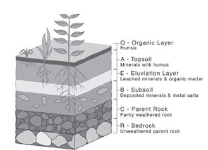
Soil Horizons Explained
- O Horizon (Organic Layer): This topmost layer is rich in organic material, including undecomposed or partially decomposed leaves, twigs, mosses, and lichens. It plays a pivotal role in providing nutrients to the layers below.
- A Horizon (Topsoil): Directly beneath the O horizon, the A horizon is fertile and rich in decomposed organic matter mixed with weathered rock minerals. It is crucial for plant growth due to its high nutrient content and is often the focus of agricultural practices.
- E Horizon (Eluviation Layer): Characterized by heavy leaching, the E horizon has lost most of its minerals and organic content, leaving a concentration of sand and silt particles. It is typically lighter in color and nutrient-poor.
- B Horizon (Subsoil): Below the E horizon, the B horizon is a zone of accumulation (illuviation) where nutrients and particles leached from the layers above are deposited. It is rich in iron, aluminum, clay, and some organic matter, providing a secondary zone of fertility in some soil types.
- C Horizon (Parent Material): Composed of loose or partially weathered rock material, the C horizon serves as the foundational layer for soil development. It influences the soil’s texture and mineral content but is less affected by biological activity.
- R Horizon (Bedrock): The lowest layer, the R horizon, is composed of continuous, unbroken rock. It represents the parent material from which the soil horizons above have developed over time.
The Importance of Soil Horizons
The vertical arrangement of soil horizons forms the basis for understanding soil fertility, water dynamics, and ecosystem support. Each layer has a role in hydrology, nutrient cycling, and supporting plant life, with variations across different ecosystems and geographical locations. The study of soil profiles helps in predicting soil behavior under various land use practices and in the management of soil resources for sustainable development.
Soil Classification
Soil classification has evolved significantly over time, from basic observations in ancient civilizations to complex systems based on scientific analysis in the modern era. This evolution reflects our growing understanding of soil as a resource critical to agriculture, ecology, and human civilization.
Ancient and Medieval Soil Classification
In ancient times, the classification of soil was rudimentary, largely based on its fertility. The simplest categorization identified soils as either fertile (Urvara) or sterile (Usara), a distinction that directly impacted agricultural practices and settlement patterns. During the medieval period, this classification became slightly more sophisticated, with soils categorized by observable characteristics such as color, moisture content, and texture. This period recognized the primary soil types that are familiar today:
- Sandy
- Clayey
- Silty
- Loamy
These categories provided a basic framework for understanding soil properties, influencing agricultural methods and land use decisions based on the soil’s physical characteristics.
Modern Soil Classification by the ICAR
The Indian Council of Agricultural Research (ICAR) has developed a more detailed soil classification system that reflects the complex nature and character of soils. This system categorizes Indian soils into several major groups, each representing a specific set of properties and formation processes. The percentages indicate their relative abundance in India:
- Inceptisols (39.74%): Young soils that have begun to show some horizon development. They are typically found in areas of varying topography and are known for their moderate fertility.
- Entisols (28.08%): Soils with little to no horizon development, often found in newly deposited soil materials such as river valleys or sand dunes. Despite their lack of development, some Entisols can be highly fertile, especially those in floodplains.
- Alfisols (13.55%): Soils with a clay-enriched subsoil and significant organic matter content. They are generally fertile and found in semi-arid to humid areas, supporting a wide range of vegetation.
- Vertisols (8.52%): Clay-rich soils that swell when wet and shrink upon drying, creating distinctive deep cracks. These soils are challenging for building and farming but can be highly productive with appropriate management.
- Aridisols (4.28%): Soils found in arid regions with very low organic matter content. They are often saline or alkaline and require irrigation for agricultural use.
- Ultisols (2.51%): Acidic soils with a clay-enriched subsoil and low base saturation. They are typically found in humid, tropical, and subtropical regions and require amendments to support agriculture.
- Mollisols (0.40%): Soils with a thick, dark, organic-rich surface layer. They are among the world’s most fertile soils, found in temperate grasslands and known for supporting extensive agriculture.
- Others (2.92%): This category includes various other soil types not classified into the above groups, reflecting the diversity of India’s soil resources.
The Significance of Soil Classification
Modern soil classification systems, like that of the ICAR, provide valuable insights into soil management and conservation. By understanding the characteristics of different soil types, agronomists, and land managers can implement appropriate agricultural practices, land use planning, and conservation strategies to maintain soil health and productivity. This classification also aids in predicting soil behavior under different environmental conditions and management practices, ensuring sustainable use of soil resources for future generations.
On the Basis of Genet
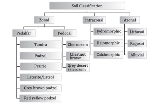
To explore the concept of soil genesis and classification, it’s essential to understand how soils are categorized based on their formation processes and environmental influences. Soils are broadly classified into three major types based on their genetic conditions: Zonal, Intrazonal, and Azonal soils. Each category reflects the influence of different environmental factors, such as climate, vegetation, parent material, and topography, on soil development.
1. Zonal Soils
Zonal soils are primarily influenced by climate and vegetation, forming under stable conditions over long periods. These soils are characteristic of broad geographical zones and reflect the major climatic and biotic conditions of those areas.
1.1 Pedalfers
Pedalfers are found in regions with a net moisture surplus, where precipitation exceeds evapotranspiration. They typically have high organic matter content and are acidic.
- 1.1 Podzols: Found in Taiga regions, characterized by leached, acidic soils with a distinctive layering effect due to organic matter and iron/aluminum movement.
- 1.2 Tundra Soils: Occur further north of Taiga, in the Tundra biome, with permafrost affecting soil development.
- 1.3 Brown Earth: Present in temperate or Boreal forests, these soils have a good structure and fertility due to a balance of moisture and organic decomposition.
- 1.4 Ferrosol: Found in tropical highlands, rich in iron and aluminum oxides, giving them a reddish color.
1.2 Pedocals
Pedocals accumulate calcium carbonate and are characteristic of drier regions where evaporation exceeds precipitation.
- 2.1 Chernozems: Found in semi-arid regions, known for their dark, fertile topsoil rich in humus and calcium.
- 2.2 Seirozems: Occur in desert or arid areas, with less organic content compared to Chernozems.
- 2.3 Chestnut Soils: Transition soils between Chernozems and Seirozems, with moderate fertility.
- 2.4 Prairie Soils: Located between the regions of Chernozem and Brown Earth soils, typical of grassland ecosystems.
2. Intrazonal Soils
Intrazonal soils reflect the influence of local factors like relief, parent material, or age more than the broad climatic or vegetative zones. They occur within zonal soils but have distinct characteristics.
- 1 Hydromorphic: Waterlogged, acidic soils with a significant peat layer, influenced by poor drainage.
- 2 Halomorphic: Form over bedrock rich in limestone, basic in nature due to the presence of salts.
- 3 Calcimorphic: Develop from calcareous parent materials, often found in semi-arid to arid conditions where evaporation concentrates calcium carbonate in the soil profile.
3. Azonal Soils
Azonal soils have a transported origin, meaning they are developed from materials deposited by erosion and transportation processes. They are generally immature and lack a well-developed soil profile.
- 1 Regosols: Found in desert regions, these are transported soils from other areas, typically lacking structure and organic matter.
- 2 Lithosols: Occur in mountainous and rocky areas, with shallow soil depth and limited development due to steep slopes.
- 3 Alluvial Soils: Located along riverbanks and in active flood plains, formed from sediments deposited by water. They are usually fertile and well-suited for agriculture due to the renewal of nutrients from flooding.
This classification provides a framework for understanding how different environmental factors contribute to soil formation and characteristics. Zonal soils reflect broad ecological zones, Intrazonal soils are influenced by local conditions, and Azonal soils are defined by their material origins rather than specific environmental factors.
Morphological Classification
The morphological classification of soils by the United States Department of Agriculture (USDA) is a system used to categorize soils based on observed properties, including texture, structure, color, depth, and water-holding capacity. This classification helps in understanding soil behavior for agricultural, environmental, and engineering applications.
1. Entisols
Definition: These are recently formed soils that lack well-developed horizons (distinct layers).
Characteristics: They are often found in areas of recent erosion or deposition, such as river valleys, dunes, or glacial outwash plains.
Agricultural implications: Their properties vary widely depending on the parent material and local environmental conditions.
2. Inceptisols
Definition: Young soils that have begun to show some development of horizons but are not fully mature.
Characteristics: They have more defined structure than Entisols but less than more mature soils, indicating the beginning (inception) of soil formation processes.
Agricultural implications: They can support a wide range of vegetation and agricultural uses depending on their specific composition and location.
3. Vertisols
Definition: Soils with distinct vertical cracks during the dry season due to their high clay content.
Characteristics: These cracks can invert the soil profile as materials from the surface are pulled down into the cracks. They are rich in lime, manganese, and calcium.
Agricultural implications: While difficult to manage due to their tendency to expand and contract, they are fertile and can support intensive agriculture when properly managed.
4. Aridisols
Definition: Soils of arid (dry) regions with limited organic matter due to the lack of moisture.
Characteristics: They have distinct horizons that include accumulations of salts, gypsum, or calcium carbonate.
Agricultural implications: These soils require irrigation to be agriculturally productive and are prone to salinization if not managed properly.
5. Mollisols
Definition: Soft, deep, fertile soils typical of grassland ecosystems.
Characteristics: They have a thick, dark topsoil (mollic epipedon) rich in organic matter, similar to the chernozems of Eastern Europe.
Agricultural implications: Highly productive for agriculture, especially for cereal crops and grazing.
6. Alfisols
Definition: Soils with high aluminum and iron content.
Characteristics: They have a clay-enriched subsoil and are typically found in temperate forests.
Agricultural implications: Generally fertile and good for agriculture, provided that adequate moisture is available.
7. Oxisols
Definition: Highly weathered soils found in tropical and subtropical regions.
Characteristics: They have a high content of iron and aluminum oxides and very low natural fertility due to the leaching of nutrients.
Agricultural implications: Require significant management and fertilization for agricultural use.
8. Ultisols
Definition: Acidic soils with a significant amount of nutrient leaching.
Characteristics: They have a clay-enriched subsoil and are often found in humid, temperate, and tropical regions.
Agricultural implications: They can be made productive with the addition of lime and fertilizers to correct acidity and replenish nutrients.
9. Andisols
Definition: Soils formed from volcanic ash and materials.
Characteristics: They are typically young, fertile, and have unique physical properties due to volcanic glass content.
Agricultural implications: Highly productive for a variety of crops when managed for their unique properties.
10. Gelisols
Definition: Soils of cold climates containing permafrost within two meters of the surface.
Characteristics: They exhibit seasonal thawing and can be very hard in winter and swampy in summer.
Agricultural implications: Limited agricultural use due to the cold climate and presence of permafrost, though they support certain types of grazing.
11. Histosols
Definition: Soils composed mainly of organic material, such as peat and muck.
Characteristics: They are found in wetlands and have a high capacity to retain water.
Agricultural implications: Fertile and productive for certain crops but require drainage and careful management to prevent subsidence and carbon loss.
12. Spodosols
- Definition: Acidic soils with a characteristic ash-colored layer beneath the surface.
- Characteristics: They are often found under coniferous forests and have a horizon of accumulated organic acids and aluminum, with or without iron.
- Agricultural implications: They have low fertility but can be used for forestry and certain specialized
On the Basis of Genesis, Colour, Composition and Location
Alluvial soil
- Alluvial soil is one of the most fertile and widely spread soil types in India, significantly impacting the country’s agricultural productivity. Understanding alluvial soil on the basis of genesis, color, composition, and location provides comprehensive insights into its characteristics, formation, and agricultural importance.
Genesis
- Alluvial soil originates from the sediments deposited by rivers and streams. These soils are formed by the accumulation of silt, sand, and clay brought by flowing waters, which settle down in river beds, floodplains, and deltas. The process of deposition varies with the velocity of water, leading to different textures of soil at different locations. This dynamic process results in the creation of highly fertile land, as fresh deposits are continually added, enriching the soil with minerals.
Colour
- The color of alluvial soils ranges from light grey to ash grey. This color variation is primarily due to the organic matter content and the mineral compositions such as iron oxide. The presence of water also affects the soil’s color, with wetter soils tending to be darker. The color not only serves as an indicator of the soil’s fertility but also reflects the variation in its composition across different regions.
Composition
- Alluvial soils exhibit a varied texture, ranging from sandy to loamy. They are known for being rich in potash but poor in phosphorus. The variation in texture and composition is attributed to the differential settling of particles transported by water. Finer particles like clay and silt travel farther, leading to loamier soils in the eastern parts, while coarser particles like sand settle earlier, resulting in sandier soils in the western parts of the plains.
- Bhangar and Khadar: In the upper and mid-Ganga plains, two distinct types of alluvial soils have developed:
- Bhangar: Represents the older alluvium, forming slightly elevated terraces. It is generally more clayey and contains caliche (kankar) nodules.
- Khadar: The newer, younger alluvium found in the lower areas of the floodplains, replenished almost annually by river floods. It is finer and more fertile than Bhangar.
Location
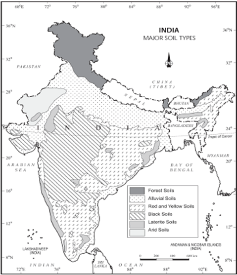
Alluvial soils cover a vast area across the northern plains and river valleys of India, extending through:
- Northern Plains: Encompassing a large part of the Indo-Gangetic and Brahmaputra plains, these soils support the cultivation of a variety of crops due to their fertility.
- Rajasthan and Gujarat Plains: Through a narrow corridor in Rajasthan, extending into the plains of Gujarat, alluvial soils support agriculture even in semi-arid conditions.
- Peninsular India: Found in the deltas of the east coast rivers like the Godavari, Krishna, and Cauvery, and in river valleys, contributing to the rich agricultural landscape of the region.
Agricultural Importance
- The intensive cultivation of alluvial soils is attributed to their high fertility and good moisture-retaining capacity. These soils support a wide range of crops, including rice, wheat, sugarcane, and various vegetables and fruits, making them a cornerstone of the agricultural economy in the regions they are found. The variation in soil types, from Bhangar to Khadar, also allows for the diversification of crops, enhancing the agricultural productivity of these areas.
Black Soil
Characteristics
- Also Known As: Regur soil or Black cotton soil.
- Texture: Generally clayey, deep, and impermeable, making it excellent for retaining moisture.
- Moisture-Holding Capacity: High, which is beneficial for crops that require a lot of water.
- Cracking: Develops wide cracks during the dry season, which aids in aeration and can mimic the effects of ploughing.
- Nutrient Content: Rich in lime, iron, magnesium, potash, and alumina. However, it lacks phosphorus, nitrogen, and organic matter, which are crucial for some types of vegetation.
- Color: Varies from deep black to grey, depending on the organic content and the moisture present.
Area
- Deccan Plateau: Predominantly covers Maharashtra, Madhya Pradesh (MP), Gujarat, Andhra Pradesh, and some areas of Tamil Nadu (TN), representing a significant portion of India’s central and southern regions.
Red and Yellow Soil
Characteristics
- Formation: Develops on crystalline igneous rocks in areas of low rainfall.
- Color: The red color is due to the presence of iron diffused in crystalline and metamorphic rocks. It appears yellow when it occurs in hydrated forms.
- Fertility: More fertile when fine-grained and less fertile when coarse-grained.
- Nutrient Content: Generally poor in nitrogen, phosphorus, and humus, limiting its fertility in its natural state.
Area
- Location: Found in the eastern and southern parts of the Deccan plateau, along a narrow stretch of the Western Ghats, and parts of Odisha, Chhattisgarh, and the southern part of the middle-Ganga plains.
Laterite Soils
Characteristics
- Formation Conditions: Develop in areas with high temperature and high rainfall, which leads to intense leaching.
- Leaching: Lime and silica are leached away, leaving the soil rich in iron oxide and aluminium compounds.
- Organic Content: The humus or organic matter is quickly broken down by bacteria due to the warm and wet conditions, making it poor in organic content.
- Nutrient Content: Generally poor in nitrogen, potash, and calcium.
- Agricultural Use: Can be made suitable for cultivation by the application of fertilizers and manure. It is particularly suitable for plantation crops like tapioca and cashew nuts.
- Other Uses: The soil is also widely used for making bricks due to its rich iron content and physical properties.
Area
- Location: Red laterite soils are found in Tamil Nadu, Andhra Pradesh, and Kerala. Additionally, Karnataka, Madhya Pradesh, Odisha, and Assam also have significant areas of laterite soils.
Each of these soil types plays a crucial role in India’s agricultural landscape, supporting a wide range of crops based on their specific properties. The management and conservation of these soils are vital for sustainable agriculture and food security in the region.
Arid Soils
Characteristics
- Color: Varies from red to brown, indicative of their mineral content and oxidation state.
- Texture: Generally sandy and saline, which affects their capacity to retain water and nutrients.
- Salt Content: In some areas, the salt content is high enough to allow for salt extraction.
- Climate Conditions: Found in areas with high temperatures, accelerated evaporation, and dry climates, leading to a lack of moisture and organic matter.
- Nutrient Content: Characterized by insufficient nitrogen but some presence of phosphates, which can support certain types of vegetation if managed properly.
- Water Seepage: Presence of a kankar layer in the lower horizon, which prevents water from seeping deeper into the ground.
- Agricultural Potential: Can be made suitable for agriculture with appropriate irrigation methods.
Area
- Location: Primarily developed in western Rajasthan, where the climate and topographical conditions favor the formation of arid soils.
Saline Soils
Characteristics
- Also Known As: Usara soils.
- Salt Content: High levels of sodium, potassium, and magnesium make these soils saline and generally infertile for most vegetative growth.
- Texture: Ranges from sandy to loamy, but lacking in nitrogen and calcium, crucial for plant growth.
- Environmental Conditions: Occur in arid and semi-arid regions, as well as waterlogged areas where evaporation exceeds precipitation.
- Development Factors: Seawater intrusion near deltas and excessive irrigation in agricultural areas can promote the development of saline soils.
- Impact of Agriculture: The Green Revolution areas are now seeing an increase in saline soils due to excess irrigation practices.
Area
- Location: Found in western Gujarat, the Sundarbans of West Bengal, deltas of the east coast, and parts of Punjab, Haryana, and Western Uttar Pradesh due to over-irrigation.
Peaty Soils
Characteristics
- Environment: Found in areas with heavy rainfall and high humidity, where there is abundant vegetative growth.
- Organic Content: High in organic matter and humus, contributing to their fertility in specific conditions.
- Texture and Color: Have a heavy texture and are black in color, which can sometimes be alkaline.
- Suitability: Ideal for certain types of crops that thrive in rich organic conditions.
Area
- Location: Present in northern Bihar, southern Uttarakhand, and the coastal areas of West Bengal, Odisha, and Tamil Nadu, where the conditions are conducive to their formation.
Forest Soils
Characteristics
- Variability: The texture and structure of forest soils vary greatly depending on the local environment, including the type of vegetation and the amount of rainfall.
- Composition: They can be loamy and silty on valley sides, while being coarser on upper slopes. In the snow-bound areas of the Himalayas, they are acidic with low humus content.
- Adaptability: These soils adapt to support the diverse forest ecosystems, providing the necessary nutrients and structure for a wide range of plant species.
Area
- Location: Found across forested regions that receive sufficient rainfall to support dense vegetative growth, contributing to the biodiversity and ecological balance of these areas.
Each soil type, with its unique characteristics and distribution, plays a crucial role in shaping the natural landscape, agricultural practices, and ecosystems of their respective regions. Understanding these soils is essential for effective land management, agricultural productivity, and environmental conservation.
Factors Controlling Formation of Soil
| Factor | Impact on Soil Formation |
| Parent Material | · Direct influence from the underlying rocks is evident in young soils, which have a strong connection to their parent material. For instance, soils over limestone regions may weather relatively quickly due to limestone’s chemical reactions with weathering agents, resulting in soils that are naturally alkaline with high pH values and enhanced water retention capabilities. |
| Climate | · Temperature and moisture influence weathering patterns and leaching rates.
· Wind plays a role in redistributing sand and other particles, notably in arid regions. · Biological activity, vegetative growth, and chemical reaction rates vary across different climates, with warmer areas experiencing increased chemical activities. This difference explains why tropical soils typically have deeper profiles compared to those found in colder Tundra regions. |
| Topography | · The physical landscape, including relief, slope, and aspect, affects soil moisture and temperature.
· Steep slopes are prone to losing topsoil, often resulting in thinner soil layers compared to level areas. · Soil characteristics can vary significantly based on the local conditions of the slope, with cool and moist slopes supporting different soil types than those found in warm and dry conditions. |
| Biological Factors | · The presence of plants, animals, and microbes plays a crucial role in soil formation by altering its structure, which can affect water retention and fertility. For example, the decomposition of shallow roots adds organic matter to the soil.
· Vegetation contributes organic material while animals help incorporate this material into the soil, enhancing its fertility and nurturing its development. |
| Time | · Soil formation is a time-dependent process, requiring prolonged periods for the interaction of the above factors with the parent material.
· Soils evolve over time, with recently deposited sediments by rivers showing little to no soil development features initially. Over time, these interactions contribute to the development of a soil profile, highlighting the importance of time in the pedogenic process. |
Major Soil Forming Processes
| Soil Forming Process | Details |
| Translocation | Translocation involves the movement of soil materials either vertically (downwards through leaching or upwards through capillary action) or horizontally within the soil profile. This process can redistribute nutrients, organic matter, and minerals within the soil, affecting its structure and fertility. |
| Organic Changes | This process is characterized by the decomposition of plant and animal materials at the soil surface. Over time, the decay of organic matter contributes to the formation of humus, enhancing soil fertility, water retention, and structure. |
| Podzolization or Cheluviation | Podzolization involves the leaching of iron, aluminum, and organic compounds from the upper layers to the lower horizons, often leaving a characteristic ash-grey color in the upper layers. This process is common in acidic soils found in cooler regions with significant moisture surplus and a good supply of organic material from conifer needles. It results in the formation of podzols, which are typically poor in nutrients. |
| Gleying | Occurring in waterlogged conditions, gleying creates a gley horizon characterized by reduced iron oxides, which give the soil a bluish-grey color. The anaerobic conditions lead to specific chemical reactions that can restrict root growth and affect soil fertility. |
| Desilication | In the warm, humid climates of the tropics, desilication removes silica from the upper layers of the soil, concentrating iron and aluminum oxides and forming hard lateritic layers. These soils are often rich in these oxides but may be poor in nutrients necessary for plant growth. |
| Salinization | Salinization is the accumulation of soluble salts in the soil surface layers, often as a result of strong capillary action in arid and semi-arid regions or due to over-irrigation practices. High salt concentrations can inhibit plant growth, leading to the formation of saline soils that are challenging for agriculture. |
| Alkalisation (Alkalization) | Similar to salinization but specifically involving the accumulation of sodium carbonate or calcium carbonate, alkalization increases soil pH, making the soil more alkaline and impermeable. This process forms sodic soils, which can severely limit the types of plants that can grow due to both physical and chemical soil constraints. |
Soil erosion
Soil erosion is a significant environmental concern that affects the sustainability of agricultural practices, water quality, and the stability of natural landscapes. It involves the removal of the top layer of soil, which is crucial for plant growth and ecosystem health. This process is primarily driven by natural agents such as wind and water, which can work independently or in conjunction to transport soil particles away from their original location. The impact of soil erosion extends beyond the mere loss of soil; it disrupts the soil profile, reduces soil fertility, and can lead to a decline in agricultural productivity and environmental quality.
Causes of Soil Erosion
- Wind Erosion: Predominantly occurs in arid and semi-arid regions where vegetation cover is sparse, and loose soil is easily picked up by the wind. This type of erosion is common in areas like Rajasthan, Gujarat, parts of Haryana, and Ladakh in India. Wind erosion can lead to the formation of dust storms, reducing air quality and depositing sand and dust over large areas.
- Water Erosion: This is more prevalent in regions with high rainfall intensity and steep slopes. The kinetic energy of falling raindrops and the flowing water on the surface can detach soil particles and transport them away. Western Ghats and the North Eastern states of India are notable examples where water erosion is a significant concern. Water erosion is considered the most dominant cause of soil erosion both globally and in India.
Types of Soil Erosion
To better understand the various manifestations of soil erosion, here’s a detailed look at its different types:
| Type of Erosion | Description |
| Splash Erosion | Occurs when raindrops strike the soil surface with enough force to dislodge soil particles. This is the initial stage of the erosion process, where water impacts directly contribute to soil detachment. |
| Rill Erosion | Characterized by the removal of soil along small channels or rills formed by running water. These channels appear as finger-shaped grooves on the surface, often observed in agricultural fields after heavy rain. An example is the Chos of Punjab. |
| Gully Erosion | When rills become deeper and wider, they evolve into gullies, which are more pronounced erosional features resembling small valleys or ditches. Continuous erosion can lead to the formation of ravines, such as those found in the Chambal badlands. |
| Sheet Erosion | Involves the uniform movement of a thin layer of soil across a surface, especially in areas with little to no vegetation cover. This form of erosion is typical in hilly regions with steep slopes, where the entire top layer of soil can be washed away or blown by the wind. |
Impact and Management
The consequences of soil erosion extend to reduced agricultural productivity, loss of soil fertility, and sedimentation in water bodies, which can lead to decreased water quality and aquatic life disturbances. Managing soil erosion involves implementing conservation practices such as afforestation, contour plowing, and the construction of terraces and retention walls to reduce runoff and increase water infiltration. Adopting no-till farming practices and maintaining a vegetative cover on the soil surface can significantly reduce the risk of erosion by water and wind.
Understanding and addressing the causes and types of soil erosion are crucial steps toward sustainable land management and environmental conservation. Through comprehensive soil conservation techniques and practices, it is possible to mitigate the effects of erosion and protect soil resources for future generations.
Human Activities Responsible for Erosion
| Human Activity | Details and Impact on Erosion |
| Deforestation | · Major cause of soil erosion: The removal of trees and vegetation cover leads to a decrease in soil cohesion, as roots that bind the soil are removed. This makes the soil more susceptible to being carried away by wind or water.
· Worsened impact in hilly regions: In areas with slopes, the absence of vegetation exposes soil to the direct impact of raindrops and surface runoff, significantly increasing erosion rates. · Reduction in water percolation: With fewer plants to absorb water, more water runs off the surface, carrying soil particles with it, and reducing groundwater recharge. |
| Faulty Agriculture Methods | · Improper ploughing techniques: Ploughing parallel to slopes can encourage the rapid movement of water across the surface, leading to increased runoff and soil loss.
· Monoculture practices: Repeatedly growing the same type of crop depletes specific nutrients, reducing soil fertility and its ability to support plant life, which can lead to increased erosion. · Overuse of fertilizers: Heavy reliance on chemical fertilizers can deteriorate soil structure, making it friable and prone to being washed or blown away. Excessive nitrogenous fertilizers can also acidify soil and promote nutrient leaching. · Shifting cultivation: This practice involves clearing forested land for farming and then moving on once fertility is lost. The abandoned land, stripped of vegetation, is highly susceptible to erosion. |
| Overgrazing by Cattle | · Soil compaction and destabilization: Continuous grazing, especially during dry periods, compacts the soil and damages its structure due to trampling by livestock. Compacted soil has reduced infiltration, leading to more surface runoff and erosion.
· Loss of vegetative cover: As animals consume plants, the protective vegetative cover is diminished, leaving soil exposed to erosion agents such as wind and water. · Increased soil erosion during dry periods: The combination of dry conditions and the absence of sufficient plant cover makes soil highly vulnerable to wind and water erosion. |
Soil erosion
Soil erosion is a significant environmental challenge that affects not just the physical landscape but also has profound implications for agricultural productivity, water resources, biodiversity, and socio-economic stability.
1. Impact on Agricultural Productivity
Loss of Topsoil: The top layer of soil, known for its high fertility due to the accumulation of organic matter and nutrients, is the most susceptible to erosion. When erosion removes this layer, the remaining soil has lower fertility, leading to a decline in agricultural productivity. This decrease is because the eroded soil lacks the essential nutrients and organic matter needed for crops to thrive.
2. Nutrient and Mineral Loss
Flooding and Leaching: Soil erosion often results in the removal of minerals and nutrients from the soil through processes like flooding and leaching. Flooding can wash away the fertile top layer of soil, while leaching refers to the process where water passing through the soil dissolves and carries away essential nutrients. Both of these processes deplete the soil of its natural fertility, further diminishing agricultural productivity.
3. Water Resource Depletion
Lowered Groundwater Levels: Soil acts as a sponge that retains water, which gradually percolates down to replenish groundwater. Erosion reduces this retention capacity, leading to lower groundwater levels. The decrease in soil moisture also affects the availability of water for agricultural and other uses, exacerbating water scarcity issues.
4. Desertification
Loss of Natural Vegetation: As soil erosion progresses, it can lead to the drying up of natural vegetation. The loss of vegetation cover further accelerates soil erosion, as there are no roots to hold the soil in place. This vicious cycle often results in the expansion of arid lands, a process known as desertification. Desertification not only reduces the land’s agricultural potential but also impacts biodiversity and disrupts ecosystems.
5. Increased Landslide Incidence
Vulnerability in Hilly Areas: Soil erosion significantly increases the incidence and impact of landslides, especially in hilly and mountainous regions. Without vegetation to anchor the soil, and with the structural integrity of the soil compromised, slopes become more susceptible to landslides. These events can have devastating effects on human settlements and infrastructure, as well as on natural habitats.
6. Socio-economic Problems
Agricultural Distress and Food Insecurity: The decline in agricultural productivity can lead to agricultural distress among farming communities, exacerbating food insecurity issues. This distress can result from lower crop yields, reduced income for farmers, and increased vulnerability to market fluctuations and extreme weather events.
- Loss of Livelihood and Rural Migration: With farming becoming less viable due to soil erosion, many people may lose their primary source of income, prompting rural migration. This migration is often directed towards urban areas, leading to overcrowding and increased pressure on urban infrastructure and services.
- Farmer Suicides: In some cases, the severe economic strain and lack of support systems can lead to tragic outcomes such as farmer suicides. This extreme consequence highlights the critical need for effective soil conservation measures and support for affected communities.
Soil conservation
Soil conservation encompasses a wide range of practices and methodologies aimed at maintaining soil fertility, preventing soil erosion and exhaustion, and improving the conditions of degraded soils. These methods are critical for sustainable agriculture, environmental protection, and ensuring food security.
1. Land Use Management
Gradient Limitation: Lands with a slope of 15-25 percent gradient should ideally not be used for cultivation. This guideline helps to prevent rapid runoff of water, which can lead to soil erosion.
Terracing: Terraces are carefully constructed on slopes to create flat areas where farming can be done more safely. This method reduces water runoff and soil erosion by breaking the length of the slope.
2. Preventing Destructive Practices
Shifting Cultivation and Overgrazing Control: Limiting shifting cultivation and controlling overgrazing are essential to prevent soil degradation. These practices, when unregulated, can strip the soil of its fertility and lead to erosion.
3. Agricultural Methods
- Contour Bunding and Terracing: These practices involve farming along the contours of slopes to prevent water and soil runoff, helping to conserve soil moisture and reduce erosion.
- Regulated Forestry: Implementing a policy where trees are replanted to replace those that are cut ensures sustainable forest management and soil conservation.
- Controlled Grazing: Managing grazing intensity to prevent overuse of land helps in maintaining soil structure and fertility.
- Cover Cropping: Using crop residues to cover the soil helps in preventing erosion, maintaining soil moisture, and adding organic matter to the soil.
- Mixed Farming: Combining crop cultivation with animal raising diversifies land use, which can enhance soil fertility and structure.
- Crop Rotation: Growing a variety of crops in sequential seasons on the same land helps in maintaining soil health, reducing pest buildup, and improving soil structure and fertility.
- Conservation Agriculture: Practices like minimum tillage, leaving crop residue on the surface, and crop rotation as per regional and climatic requirements are key to reducing erosion and improving soil health.
- Zero Tillage: This method involves minimal disturbance of the soil and not burning the previous crop’s residue, promoting carbon sequestration and preserving soil structure.
4. Soil Health Monitoring
Soil Health Card Scheme: This initiative helps in identifying the specific needs of the soil and prescribing the right quantity and type of fertilizers, thereby preventing overuse and promoting soil health.
5. Erosion Control
Preventing Gully Erosion: Techniques like terracing and constructing check dams help in controlling gully erosion. Planting vegetation at the head of gullies can also be effective.
Shelterbelts: In arid regions, creating shelterbelts or ‘green walls’ of trees can help in reducing wind erosion and desertification.
6. Land Rehabilitation
Conversion to Pastures: Land that is unsuitable for cultivation can be converted into pastures for grazing, which, if managed properly, can help in soil restoration.
Afforestation: Planting trees in deforested or degraded areas helps in restoring soil health, preventing erosion, and enhancing biodiversity.
These soil conservation practices are not only crucial for maintaining the productivity and sustainability of agricultural lands but also for protecting the environment and supporting socio-economic stability. Implementing these practices requires a collaborative effort among farmers, policymakers, and environmental organizations to ensure the long-term health and productivity of the soil.
UPSC PREVIOUS YEAR QUESTIONS
1) With reference to agricultural soils, consider the following statements: (2018)
1. A high content of organic matter in soil drastically reduces its water holding capacity.
2. Soil does not play any role in the sulphur cycle.
3. Irrigation over a period of time can contribute to the salinization of some agricultural lands.
Which of the statements given above is/are correct?
(a) 1 and 2 only (b) 3 only
(c) 1 and 3 only (d) 1, 2 and 3
2) Consider the following statements: (2019)
1. Agricultural soils release nitrogen oxides into the environment.
2. Cattle release ammonia into the environment.
3. Poultry industry releases reactive nitrogen compounds into the environment.
Which of the statements given above is/are correct?
(a) 1 and 3 only (b) 2 and 3 only
(c) 2 only (d) 1, 2 and 3
3) Which of the following statements regarding laterite soils of India are correct? (2013)
1. They are generally red in colour.
2. They are rich in nitrogen and potash.
3. They are well-developed in Rajasthan and UP.
4. Tapioca and cashew nuts grow well on these soils.
Select the correct answer using the codes given below:
(a) 1, 2 and 3 (b) 2, 3 and 4
(c) 1 and 4 (d) 2 and 3 only