INDIAN CLIMATE
Introduction
- Climate and weather are fundamental concepts in understanding the atmospheric conditions that influence our daily lives, ecosystems, and the environment at large. While they are related, they differ in terms of scale, time, and variability.
- Climate refers to the aggregate weather conditions in a specific region over a long period, typically over 30 years. It encompasses the average patterns and variations in temperature, humidity, atmospheric pressure, wind, and precipitation. Climate gives us a broad understanding of the environmental conditions of a region, guiding agricultural practices, urban planning, and preparedness for climate-related phenomena.
- Weather, on the other hand, describes the state of the atmosphere over a short period, such as days or weeks. It includes temporary variations in temperature, precipitation, humidity, cloudiness, and wind conditions. Weather conditions can change rapidly and are what we experience daily.
Climate of India
- Tropical Nature Despite Northern Latitude: While the northern part of India lies in the temperate zone, north of the Tropic of Cancer, the overall climate of India is more akin to that of a tropical country. This can be attributed to several factors:
- Himalayan Barrier: The Himalayan mountain ranges act as a formidable barrier that prevents the cold air masses from Central Asia from affecting the northern parts of India, leading to milder winters compared to regions on similar latitudes.
- Equatorial Dry Climate in the South: During summer, the over-the-head position of the sun results in a climate that resembles an equatorial dry climate in the southern parts of India.
- Influence of Deserts: The presence of the Thar, Baloch, and Iranian deserts contributes to the “Loo” wind phenomenon — a hot, dry wind that sweeps across the plains of northern India, raising temperatures to levels comparable to the country’s southern regions.
- Tropical Monsoon Climate: India’s climate is significantly influenced by the monsoon, which is characterized by the seasonal reversal of wind direction. This results in a marked wet season when the country receives the majority of its annual precipitation, primarily driven by the southwest monsoon. The monsoon system plays a crucial role in India’s agricultural calendar and water resources management.
Salient Features of Indian Climate
| Feature | Description |
| Reversal of Winds | Winter: Winds blow from the northeast, dry and cold.
Summer: Winds reverse, blowing from the southwest, bringing moisture. |
| Formation of High- and Low-pressure Zones | Winter: High-pressure areas due to low temperatures in the north.
Summer: Low-pressure areas in the northwest due to intense heating, causing widespread rainfall. |
| Seasonal and Variable Rainfall | Varied precipitation across regions: Snow in the Himalayas; heavy rainfall in Meghalaya; scant rainfall in Ladakh and western Rajasthan.
Majority of rainfall (over 80%) occurs from June to September. |
| Multiplicity of Seasons | India experiences six seasons: winter, fall of winter, spring, summer, rainy, and autumn.
Spring and autumn are transitional, lasting 3 to 6 weeks. |
| Unity of Indian Climate | The Himalayas block cold northerly winds, ensuring a tropical climate even north of the Tropic of Cancer.
Monsoon winds are forced to shed their moisture, creating a uniform monsoon climate. |
| Diversity of Indian Climate | Regional differences due to location, altitude, and distance from the sea and mountains.
Temperature extremes range from 55°C in western Rajasthan to -45°C in Leh. |
| Characterized by Natural Calamities | Prone to floods, droughts, famines, and epidemics due to climatic extremes, especially rainfall patterns.
Supports cultivation of diverse crops across three cropping seasons (Rabi, Kharif, and Zaid) due to climatic variety. |
The Indian climate’s complexity and diversity have profound implications for the country’s agriculture, demanding adaptability and resilience from its people. Despite the challenges posed by natural calamities, the climatic conditions enable the cultivation of a wide range of crops, underscoring the importance of understanding and managing the climate’s impacts effectively.
Climatic Variation in India
- Variation in Temperature
- Extreme Temperatures: India experiences a wide range of temperatures, from the scorching 55°C in western Rajasthan during summer to the freezing -45°C in Leh, Ladakh, during winter.
- Daily Variations: On a typical day in June, temperatures in Churu, Rajasthan, might soar above 50°C, while Tawang in Arunachal Pradesh remains cool at around 19°C. Similarly, December nights can see temperatures plummet to -45°C in Drass, Ladakh, whereas coastal cities like Thiruvananthapuram or Chennai enjoy milder temperatures around 20°C to 22°C.
Variation in Temperature Range
- Diurnal Range: The difference between day and night temperatures varies significantly across India. In regions like Kerala and the Andaman Islands, the diurnal temperature range is narrow (around 7-8°C). Conversely, the Thar Desert experiences a wide range, with daytime temperatures hitting 50°C and nighttime temperatures dropping to 15-20°C.
Variation in Precipitation
- Rainfall Disparity: Precipitation in India ranges from the extremely arid conditions in Jaisalmer, Rajasthan, receiving less than 9 cm of annual rainfall, to the exceptionally wet conditions of Cherrapunji and Mawsynram in Meghalaya, where annual rainfall exceeds 1,080 cm.
- Regional Rainfall: While the western deserts and northwest Himalayas receive less than 10 cm of rainfall annually, Meghalaya benefits from more than 400 cm. The eastern and western Himalayas experience snowfall, adding another layer to India’s climatic diversity.
- Seasonal and Coastal Variations: The Coromandel coast remains dry during the monsoon season (July and August), in contrast to the Ganges delta and coastal Odisha, which experience heavy rainfall. Tamil Nadu’s coastal areas receive rainfall at the onset of winter, differing from the June-September rainfall pattern seen in most of the country.
Factors Determining the Climate of India
Factors Related to Location and Relief
- Latitude:
- Impact: India spans from the Rann of Kachchh in the west to Mizoram in the east, crossing the Tropic of Cancer. This geographical spread results in a mix of tropical and subtropical climates, with the southern half experiencing consistently high temperatures due to its proximity to the equator.
- Example: The tropical zone enjoys a narrow temperature range throughout the year due to its equatorial proximity.
- Altitude:
- Impact: Higher altitudes, such as mountainous regions, experience lower temperatures compared to the plains. This is evident from the temperature disparity between places at the same latitude but different elevations.
- Example: Agra and Darjeeling, despite being on the same latitude, have a significant temperature difference in January (16°C in Agra vs. 4°C in Darjeeling).
- Relief:
- Impact: The physical geography of India influences various climatic elements like temperature, air pressure, and rainfall distribution. The Western Ghats, for example, create a rain-shadow effect in the southern plateau.
- Example: The windward side of the Western Ghats receives heavy rainfall, while the leeward areas remain relatively dry.
The Himalayan Mountains:
- Impact: Acting as a climatic barrier, the Himalayas protect India from the cold northern winds, leading to milder winters in the subcontinent. They also trap monsoon winds, forcing them to precipitate within the region.
- Example: The Himalayas’ role in blocking cold winds contributes to warmer winters compared to Central Asia.
- Distribution of Land and Water:
- Impact: India’s peninsular shape, surrounded by water on three sides and a massive mountain range in the north, creates distinct pressure zones that influence the monsoon winds and seasonal weather patterns.
- Example: The presence of water bodies around the southern peninsula induces a moderating effect on the climate, making it less extreme than the interior.
- Distance from the Sea:
- Impact: Proximity to the sea moderates the climate, reducing the extremity of weather conditions. Areas far from the sea experience more pronounced temperature variations, a phenomenon known as continentality.
- Example: Coastal regions have milder climates compared to the interior, which experiences extreme weather.
- Physiography:
- Impact: The orientation of mountain ranges and the topography significantly affect rainfall patterns. The Western Ghats, for instance, receive abundant rainfall due to their perpendicular strike to the monsoon winds, whereas areas on their leeward side fall into a rain-shadow zone.
- Example: The Meghalayan plateau’s orographic uplift and funneling effect make it one of the wettest places on Earth, with Mawsynram and Cherrapunji receiving annual rainfall exceeding 1100 cm.
Factors Related to Air Pressure and Wind
- Wind and Air Pressure Distribution: The surface distribution of wind and air pressure significantly influences weather patterns.
- Global Weather Factors: The inflow of air masses, jet streams, and upper air circulation play critical roles in shaping weather conditions.
- Tropical Depressions and Cyclonic Disturbances: These phenomena contribute to rainfall during the south-west monsoon and winter seasons, respectively.
Least Rainfall in Gujarat and Rajasthan
- Monsoon Winds and Orographic Rainfall: In Gujarat and Rajasthan, the monsoon winds flow parallel to the Aravalli range, which acts neither as an orographic barrier to cause significant uplift and cooling of air nor contributes to rainfall through orographic means. This results in minimal or no orographic rainfall in these areas.
- Wind Movements: There’s a predominance of horizontal wind movements over vertical in these regions. The winds are directed towards low-pressure areas in Tibet, limiting the development of vertical wind movements or convection cells that are crucial for rainfall.
- Subtropical High Pressure Belt (STJ): The Subtropical Jet Stream (STJ) during winter causes strong air divergence above these regions, further reducing the possibility of rainfall.
- Funnelling Effect: This phenomenon refers to the channeling of winds and clouds through narrow regions between mountains, which can increase cloud density and wind speed. However, this effect is more pronounced in regions with significant mountain barriers like the Western Ghats, Eastern Ghats, and parts of the Himalayas, rather than in the relatively flat terrains of Gujarat and Rajasthan.
Rainfall Variation in the Indus-Ganga Plains
- Low Pressure Cells: During summer, the existence of minor low-pressure cells across the plains attracts monsoon winds. As these winds travel from east to west, they lose moisture with each successive low-pressure zone, leading to decreased rainfall towards the western parts of the plains.
- Western Cyclonic Disturbances: In contrast, winter months see rainfall in the western regions due to the influence of Western cyclonic disturbances, distinct from the summer monsoon pattern.
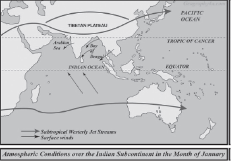
Mechanism of Weather Conditions in Winter
- Distinct Winter Season North of the Tropic of Cancer: Characterized by clear skies, pleasant weather, low humidity, and cool northeast trade winds. The temperature variation is considerable, especially in the interior regions.
- Temperature and Pressure Variations: The temperature south of the 20°C isotherm remains above 20°C, indicating a less distinct winter season in south India. In contrast, north-west India experiences significant cold, influenced by continental climates, Himalayan snowfall, and cold winds from Central Asia.

- Surface Pressure and Winds: The high-pressure center north of the Himalayas during winter influences wind patterns, leading to dry continental air flow towards India, affecting weather conditions significantly.
- Jet Stream and Upper Air Circulation: The westerly jet stream influences weather conditions, with the subtropical westerly jet stream playing a significant role during winter.
Tropical Cyclones and Western Cyclonic Disturbance
- Influence of Cyclones: Coastal regions face the impact of tropical cyclones originating from the Indian Ocean and the Bay of Bengal, often causing destructive weather conditions.
- Western Cyclonic Disturbances: Originating from the Mediterranean, these disturbances primarily affect north and north-western India during winter, bringing rainfall and altering weather patterns.
- Western Cyclonic Disturbances: Western Cyclonic Disturbances are weather systems originating from the Mediterranean region that affect the weather of the north and north-western regions of India during the winter months. These disturbances are brought into the Indian subcontinent by the westerly flow and are responsible for most of the winter and pre-monsoon rainfall across north and north-western India. Unlike the monsoon rains, which are more widespread and predictable, the rainfall from Western Cyclonic Disturbances is more sporadic and significantly impacts agriculture and water availability in the region.
- Jet Streams: Jet streams are narrow belts of high-altitude westerly winds in the troposphere, with speeds varying from about 110 km/h in summer to approximately 184 km/h in winter. The most consistent among these are the mid-latitude and subtropical jet streams. These fast-flowing air currents have a profound influence on the weather patterns, including the movement of monsoon systems and cyclonic disturbances. The positioning and strength of jet streams can alter weather conditions across vast regions, affecting precipitation patterns, temperatures, and storm development.
- Weather Conditions in the Summer Season: The summer months in north India are characterized by high temperatures and low humidity, attributed to the northward movement of the sun, which causes an increase in temperature. This seasonal warmth is experienced differently across the country, with the southern parts warming up earlier in the year compared to the north, due to the sea’s moderating effect and the geographical tilt towards the sun.
Temperature
- High temperatures are prevalent across India just before the onset of the southwest monsoon.
- Coastal and southern peninsular regions experience comparatively lower maximum temperatures due to the sea’s moderating influence.
- Heatwaves are common in the north and central regions during this season.
Surface Pressure and Winds
- The Inter-Tropical Convergence Zone (ITCZ) shifts northward, influencing wind circulation and leading to the reversal of wind patterns over the subcontinent.
- The ITCZ’s northward movement is interrelated with the withdrawal of the westerly jet stream, affecting the onset and intensity of the southwest monsoon.
Upper Air Circulation and Jet Streams
- An easterly jet stream flows over the southern peninsula in June, influencing the distribution of monsoon rainfall across the Indian subcontinent.
- These easterly jet streams are critical in directing tropical depressions towards India, which significantly impacts the monsoon rainfall distribution.
India’s diverse climate manifests in various unique weather phenomena, including convectional thunderstorms, the hot and dry Loo winds, and dust storms known as Aandhis. These meteorological events significantly impact agriculture, daily life, and the environment across different regions of the country.
Convectional Thunderstorms
| Region | Local Name | Characteristics | Impact and Benefits |
| West Bengal, Jharkhand, Odisha, Assam | Norwesters, Kalabaisakhi, Barodoli Chheerha, Tea Showers | Caused by strong convectional movements and moist winds during Vaisakh (mid-March to mid-April). Known for short rainfalls and hailstones. | Can cause damage to crops, cattle, and infrastructure but beneficial for the cultivation of rice, jute, and tea. |
| Kerala, Karnataka, Tamil Nadu | Blossom Showers, Mango Showers | Evening and night thunderstorms common in the south, especially in Kerala. | Aids in the blossoming of coffee flowers and benefits the mango crop, hence the names Blossom and Mango Showers. |
Loo
| Origin | Characteristics | Impact |
| Thar, Baloch, and Iranian deserts | Extremely hot and dry winds blowing towards the north Indian plains in May and June, due to high temperatures creating a steep pressure gradient. | Causes discomfort and health issues like heat strokes but is a significant aspect of the region’s climatic identity. |
Aandhis
| Region | Characteristics | Impact |
| Northern Plains (Rajasthan to Bihar) | Dust storms caused by low pressure and strong convective currents, especially in May. | Reduces visibility drastically, but brings moderate rainfall and a pleasant cool breeze, offering relief from the heat. |
These weather phenomena, while sometimes causing damage and discomfort, play crucial roles in the ecological and agricultural systems of their respective regions. The Norwesters and Mango Showers are particularly awaited for their agricultural benefits, marking significant periods for the cultivation of specific crops. The Loo and Aandhis, on the other hand, are characteristic of the pre-monsoon summer season in northern India, bringing much-needed relief from the intense heat. Understanding these patterns is essential for preparing and mitigating their adverse effects while maximizing their benefits for agriculture and water resources.
The Indian Monsoon
The Indian Monsoon, a significant climatic phenomenon, greatly influences India’s agricultural cycles, water resources, and overall climate. This detailed explanation breaks down the key aspects of the Indian Monsoon, including its origin, mechanism, and effects.
- Etymology: The term “monsoon” is derived from the Arabic word “Mausim,” meaning “season,” reflecting the seasonal wind reversal observed by Arab traders who navigated to India.
- Historical Observation: Early sailors were among the first to note the monsoon winds, which significantly aided their maritime voyages to the Indian subcontinent.
Mechanism of the Indian Monsoon
- Differential Heating: The land heats up and cools down more rapidly than the surrounding seas, creating low pressure over the Indian landmass and high pressure over the sea.
- Inter Tropical Convergence Zone (ITCZ): This equatorial trough, also known as the monsoon trough during the monsoon season, moves over the Gangetic plain, influencing the monsoon.
- High-Pressure Area: The existence and position of a high-pressure area east of Madagascar significantly impact the monsoon.
- Tibetan Plateau: The extreme heating of the Tibetan plateau during summer generates strong vertical air currents and low pressure, affecting the monsoon.
- Jet Streams: The northward movement of the westerly jet stream and the presence of the tropical easterly jet stream over the Indian peninsula during the summer also play critical roles.
- Coriolis Force: An apparent force caused by the Earth’s rotation, which causes winds to deflect to the right in the Northern Hemisphere and to the left in the Southern Hemisphere, influencing the direction of the monsoon winds.
Thermal Concept
- Explanation: Proposed by Halley, this concept suggests that the differential heating of land and sea drives the monsoon, acting as an extended form of land and sea breezes on a large scale.
- Winter Season: Asia cools rapidly, creating a high-pressure zone over the continent and a pressure gradient directed from land to sea.
- Summer Season: The reversal of temperature and pressure conditions, with a low-pressure center over the heated landmass of Asia, draws warm, moist air from the oceans.
Inter-Tropical Convergence Zone (ITCZ)
- Location Shift: The ITCZ, or monsoon trough, shifts with the apparent movement of the sun, lying across the Gangetic plain in July, positioned between 20°N and 25°N latitude.
- Impact: This shift leads to the formation of a thermal low over north and northwest India, influencing the onset of the monsoon.
Different Theories on Indian Monsoon
- Classical Theory
- Origin: The first scientific study of monsoon winds was conducted by Arab traders. In the 10th century, Arab explorer Al Masudi detailed the reversal of monsoon winds and ocean currents in the north Indian Ocean.
- Halley’s Proposal: Sir Edmund Halley, in the 17th century, attributed the monsoon to thermal disparities between the continent and the ocean, due to differential heating (Thermal concept).
- Air Mass Theory
1. Concept: Based on the seasonal movement of the sun, this theory suggests that the Intertropical Convergence Zone (ITCZ) shifts across the tropics, altering trade winds.
2. Mechanism:
- During summer, the ITCZ moves to the Indo-Gangetic Plain (20-25°N), forming the Monsoon Trough.
- The northwestern part of the subcontinent heats up, creating a strong low-pressure system, which shifts the ITCZ northward.
- Southeast trade winds from the southern hemisphere cross the equator, influenced by the Coriolis force, turning into southwest monsoons upon reaching the Indian subcontinent.
- In winter, as the sun moves south, the ITCZ shifts below the equator, and the typical northeast trade winds of the northern hemisphere bring the North-East Monsoons.
- Dynamic Theory
- Acceptance: This is the most contemporary theory and has received global recognition for its comprehensive approach to understanding the monsoon.
- Features:
- Treats the monsoon as a dynamic system influenced by various factors.
- Factors include differential heating of land and sea, shifting of the ITCZ, heating of the Tibetan plateau, and the role of jet streams (Subtropical Jet, Somali Jet, and Tropical Easterly Jet).
- It also considers the impact of the Indian Ocean Dipole, El Nino, and La Nina on the monsoon’s frequency, intensity, and regularity.
The Himalayas and the Tibetan Plateau
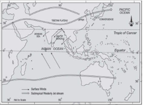
The understanding of the Indian monsoon has evolved significantly, especially with advancements in atmospheric science post the second world war. Modern theories suggest that the monsoon circulation is influenced by more than just the temperature difference between the land and the sea. This detailed explanation explores the contemporary concepts regarding the origin of the Indian monsoon, emphasizing the roles of the Himalayas, Tibetan Plateau, jet streams, and various oceanic phenomena.
The Himalayas and the Tibetan Plateau play a pivotal role in shaping the climate and weather patterns of South Asia, particularly influencing the Indian Monsoon system. Their geographical and atmospheric significance has been a subject of study since the 1970s, leading to a deeper understanding of their impact on monsoon circulation.
The Tibetan Plateau
- Geographical Expanse: The Tibetan Plateau, often referred to as “the Roof of the World,” covers an area of about 4.5 million square kilometers. It is one of the world’s most extensive and highest plateaus, with an average elevation exceeding 4,000 meters above sea level.
- Insolation: Due to its significant height, the Tibetan Plateau receives 2-3°C more insolation (solar radiation) compared to the surrounding regions. This increased heating effect plays a crucial role in initiating and sustaining the monsoon circulation in the region.
Impact on Monsoon Circulation
Middle Troposphere Circulation: The heating of the Tibetan Plateau results in the creation of a large anticyclone in the middle troposphere. This anticyclonic circulation is characterized by clockwise movement due to the Coriolis effect, influencing weather patterns far beyond the immediate region.
Origination of Wind Streams: The thermal contrast and atmospheric circulation patterns over the plateau give rise to two significant wind streams:
Tropical Easterly Jet Stream (TEJ): One stream flows southward from the Tibetan Plateau, developing into the TEJ. This jet stream plays a vital role in the dynamics of the Indian Monsoon by influencing the distribution of rainfall across the Indian subcontinent.
Westerly Jet Stream: The other stream moves in the opposite direction towards the North Pole, transforming into the westerly jet stream over Central Asia. The positioning and strength of this jet stream have implications for weather patterns across Eurasia, including the onset and progression of the monsoon season.
The Himalayas
- Natural Barrier: The Himalayan mountain range acts as a formidable natural barrier that influences climatic conditions across South Asia. By blocking the cold air masses from Central Asia, the Himalayas contribute to warmer temperatures in the Indian subcontinent, which is essential for the development of the monsoon.
- Rain Shadow Effect: The Himalayas also create a rain shadow effect for the regions lying to their north, such as the Tibetan Plateau, leading to arid conditions in these areas while enabling heavy monsoonal rains on the southern side of the range.
Role of Jet Stream in Indian Climate
- The role of jet streams, particularly in relation to the Indian climate and monsoon system, is a critical aspect of atmospheric dynamics. Jet streams are narrow bands of strong wind in the upper levels of the atmosphere. Their positioning and movement play a significant role in weather patterns globally, including the precipitation and temperature distributions associated with the Indian monsoon.
| Feature | Description |
| Winter Division | During winter, the subtropical westerly jet stream is divided by the Tibetan highlands into two branches. The northern branch flows between latitudes 20°N and 35°N. |
| Tropical Easterly Jet Stream (TEJ) | The TEJ diverges from the anticyclone over Tibet and can reach as far south as the tip of Peninsular India, influencing weather patterns across the region. |
| Jet Speed Winds | These high-speed winds have been observed over various parts of the Peninsular region, impacting local weather conditions. |
| Mascarene High Influence | Over the Indian Ocean, the descending tropical easterly jet stream intensifies the high-pressure cell known as the Mascarene High. |
| Onshore Winds Formation | The high pressure from the Mascarene High generates onshore winds that move toward the low-pressure area developed in the northern part of the Indian Ocean, significantly influencing the onset and intensity of the Indian monsoon. |
Impact on Indian Monsoon
- Onset of Monsoon: The interaction between the Mascarene High and the thermally induced low-pressure area over the Indian subcontinent is crucial for the onset of the southwest monsoon. The onshore winds contribute to bringing moist air into the Indian subcontinent, leading to significant rainfall.
- Monsoon Variability: The strength and position of the jet streams, particularly the tropical easterly jet stream, can vary annually, contributing to the variability of the monsoon in terms of timing, duration, and intensity.
- Weather Patterns: The positioning of the jet streams affects the distribution of rain and temperature across the Indian subcontinent, influencing agricultural practices, water resources, and overall economic activities.
El Niño-Southern Oscillation (ENSO)
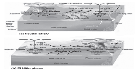
The El Niño-Southern Oscillation (ENSO) plays a significant role in influencing weather and climate patterns globally, including the Indian Monsoon. ENSO is a complex climate pattern resulting from variations in ocean temperatures in the equatorial Pacific. It has three phases: El Niño, La Niña, and the neutral phase.
ENSO and Its Impact on Indian Monsoon
| Component | Description |
| El Niño | A phenomenon characterized by the warming of the central and eastern tropical Pacific Ocean.
Leads to a reversal of the normal sea surface temperature conditions. Generally associated with a weakening of the Indian monsoon, as it tends to divert the monsoon winds away from the Indian subcontinent. |
| Southern Oscillation | Refers to the see-saw pattern of atmospheric pressure between the eastern and western Pacific Ocean.
The Southern Oscillation Index (SOI) measures the pressure differences between Tahiti and Darwin, offering insights into the phase of ENSO. Negative SOI values are typically linked with high pressure over the northern Indian Ocean during winter and a weaker monsoon in India. |
| Somali Current | Influences the Indian monsoon through changes in sea surface temperatures and wind patterns over the Indian Ocean.
The interaction with ENSO can modify the strength and direction of the monsoon winds, affecting rainfall distribution across the Indian subcontinent. |
Relationship Between ENSO and Indian Monsoon
- Interrelation: While there isn’t a direct causality between El Niño and poor monsoon seasons in India, historical data often show a correlation where El Niño years coincide with below-average monsoon rainfall.
- Droughts and El Niño: Not all droughts in India are directly caused by El Niño years, nor do all El Niño years lead to droughts. However, the probability of reduced rainfall and drought conditions in India increases during El Niño phases.
- Variability: The impact of ENSO on the Indian monsoon can vary due to the oscillation’s period, which ranges from two to seven years, and the intensity of the El Niño or La Niña events.
El Niño
El Niño is a significant climatic phenomenon characterized by the periodic warming of sea surface temperatures in the central and east-central Equatorial Pacific. This phenomenon has profound impacts on global weather patterns, including the climate and agricultural productivity of regions such as India.
Key Features of El Niño
- Origin and Naming: El Niño, meaning “the child” in Spanish, is so named because it often starts around Christmas along the coast of Peru, replacing the normally cold Peruvian current with warm ocean waters.
- Climate Interaction: El Niño is part of a larger ocean-atmosphere climate interaction that leads to marked changes in weather patterns across the globe. It is one of the phases of the El Niño Southern Oscillation (ENSO) phenomenon, which also includes the cool phase known as La Niña.
- High Pressure in the Western Pacific: The occurrence of El Niño is associated with high atmospheric pressure in the western Pacific Ocean, altering typical weather patterns, including those affecting the Indian monsoon.
Impact on the Indian Monsoon and Agriculture
- Adverse Effects on the Monsoon: El Niño typically leads to weaker monsoons in India. The shift in global atmospheric patterns during El Niño events can result in reduced rainfall over the Indian subcontinent, impacting water availability for agriculture.
- Agricultural Productivity: Given that much of India’s agriculture is rain-fed, El Niño can significantly affect crop yields by altering the timing and intensity of the monsoon rains. Droughts associated with El Niño events can lead to lower agricultural output and increased stress on water resources.
La Niña
La Niña, a significant climate phenomenon, contrasts with its counterpart El Niño by bringing cooler-than-average sea surface temperatures in the Eastern Pacific Ocean. This event has widespread impacts on global weather patterns, including droughts, flooding, and variations in temperature and rainfall across different regions of the world.
Understanding La Niña
- Definition: La Niña, translating to “Little Girl” in Spanish, refers to a climate pattern characterized by the cooling of ocean surface waters in the central and eastern Pacific Ocean. It is part of the broader El Niño-Southern Oscillation (ENSO) climate phenomenon, which includes both La Niña and El Niño (“The Little Boy,” a warming event).
- Causes: La Niña occurs when winds strengthen along the equator, upwelling deeper, cooler water to the surface in the Eastern Pacific. This reduces the ocean temperature in that region, creating a contrast with the warmer Western Pacific.
- Atmospheric Pressure Changes: The cooling of the Eastern Pacific leads to high atmospheric pressure over this area, while low pressure systems develop over Asia and the Western Pacific. This pressure differential enhances the trade winds, further cooling the Eastern Pacific and affecting global atmospheric circulation.

Impact on Weather Patterns
- Drought in Peru and Ecuador: The cooler sea surface temperatures in the Eastern Pacific reduce evaporation, leading to decreased rainfall and drought conditions along the western coast of South America.
- Severe Flooding in Australia: La Niña typically brings more moisture to Australia, resulting in higher-than-average rainfall and, consequently, flooding.
- High Temperatures in the Western Pacific and Indian Ocean: The shift in wind and ocean currents during La Niña can lead to warmer temperatures in these regions.
- Abundant Monsoon Rains in India: The phenomenon often strengthens the monsoon winds, bringing more rainfall to the Indian subcontinent, which can benefit agriculture but also cause flooding.
- Frequency and Duration: La Niña events typically occur every 4 to 5 years but are less frequent than El Niño events. They generally last between nine to twelve months, though the effects on weather patterns can extend beyond this period.
- Significance for the Indian Monsoon: La Niña is particularly beneficial for the Indian monsoon, often resulting in more abundant rains. This can enhance agricultural productivity but also poses risks of excessive rainfall and flooding.
Somali Current
The Somali Current is a key oceanic current in the Indian Ocean, playing a crucial role in the climate and monsoon system of the Indian subcontinent. Its unique characteristics and the influence it exerts on the regional climate patterns are of significant interest to oceanographers and climatologists.
Overview of the Somali Current
- Directional Change: The Somali Current is notable for its biannual reversal in flow direction. This phenomenon is driven by the changing wind patterns associated with the monsoon seasons.
- Comparison with the Gulf Stream: During the South-West Monsoon, the Somali Current’s strength and behavior are comparable to the Gulf Stream, highlighting its importance in the Indian Ocean’s circulatory system.
Behavioral Patterns
- South-West Monsoon (Summer): In this season, the Somali Current flows to the southwest, powered by the strong monsoon winds blowing from the southwest. This period is characterized by a significant increase in the current’s speed and volume, making it a dominant force along the eastern coast of Somalia.
- North-East Monsoon (Winter): Conversely, during the North-East Monsoon, the current reverses direction and flows to the northeast. This reversal is influenced by the prevailing northeast winds, though the current is generally weaker compared to its summer counterpart.
Impact on Regional Climate
- Low Pressure Area: A persistent low pressure area along the eastern coast of Somalia during the South-West Monsoon contributes to drawing the moist, southwesterly winds towards the Indian subcontinent, aiding in the onset and intensification of the monsoon rains.
- High Pressure Transformation: Occasionally, the western Arabian Sea experiences a shift from a low to a high pressure area, disrupting the usual monsoon pattern. This shift, occurring every six to seven years, can lead to a weaker monsoon in India, affecting rainfall distribution and intensity.
Consequences of Pressure Reversal
- Weaker Monsoon: The transformation of the low pressure area into a high pressure one in the western Arabian Sea is associated with weaker monsoon conditions over India. This can result in reduced rainfall, impacting agriculture, water resources, and overall socio-economic conditions in the region.
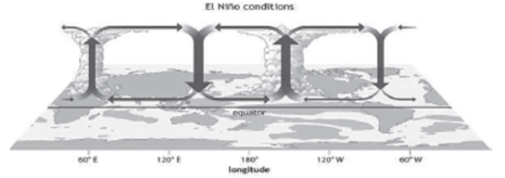
Walker Cell
The Walker Circulation, or Walker Cell, is a fundamental concept in understanding global atmospheric circulation, particularly in tropical regions. It represents a pattern of atmospheric circulation that occurs over the tropical oceanic zones, significantly affecting weather patterns across the globe, including the monsoon systems.
Definition and Functioning
- East-West Circulation: The Walker Cell describes the east-west atmospheric circulation found over the tropical oceans, most prominently over the Pacific Ocean.
- Global Circulations: While the term initially referred to Pacific Ocean circulation, it is now applied to similar east-west circulations in other oceanic regions.
- Association with Southern Oscillation: The strength of the Walker Cell is linked to the Southern Oscillation Index (SOI), influencing weather patterns such as the Indian monsoon.
Impact of SOI on Walker Cell
- High Positive SOI: A zone of low atmospheric pressure develops across Australia and the Indonesian archipelago, leading to rising air that deflects towards South America and Africa, impacting the Mascarene High.
- Atmospheric Pressure Zones: The descending branch of the Walker Cell creates high-pressure zones in the Indian Ocean, from which southwest monsoon winds blow towards the Indian subcontinent during summers.
The Indian Ocean Dipole
The Indian Ocean Dipole (IOD) is a significant ocean-atmosphere phenomenon that affects climate patterns, not just in the Indian Ocean region but also globally. Analogous to the El Niño Southern Oscillation (ENSO) in the Pacific, the IOD plays a critical role in influencing weather and climate variations across many parts of the world, including the Indian monsoon system.
| Aspect | Details |
| Definition | The IOD refers to the difference in sea surface temperature (SST) between two areas of the Indian Ocean: the western pole near the Arabian Sea and the eastern pole south of Indonesia. |
| Phases of IOD | Positive Phase: Characterized by higher-than-average SSTs in the western Indian Ocean, leading to increased precipitation in this region, while the eastern pole experiences cooling and drier conditions.
Negative Phase: Marked by warmer waters and more precipitation in the eastern Indian Ocean, with cooler and drier conditions in the western pole. |
| Impact on Weather | The IOD influences weather patterns, including monsoons, droughts, and precipitation levels, depending on its phase (positive or negative). |
| Relation with ENSO | While the IOD can occur independently, it often interacts with ENSO, affecting global climate patterns. However, there’s no direct correlation, as both positive and negative IOD events have occurred during La Niña years. |
| Influence on Monsoons | A positive IOD phase is generally favorable for the Indian monsoon, enhancing rainfall over the subcontinent due to the warm sea surface temperatures in the western Indian Ocean. Conversely, a negative IOD phase can adversely affect monsoon rainfall. |
Significance of the IOD
- Climate and Weather: The IOD significantly impacts regional climate and weather patterns, especially in countries surrounding the Indian Ocean. It affects the distribution and intensity of rainfall, influencing agricultural practices, water resources management, and disaster preparedness strategies.
- Agriculture: Given its influence on monsoon rains, the IOD directly impacts agricultural productivity in the Indian subcontinent. A positive IOD phase can lead to improved monsoon rains, beneficial for crops, while a negative phase can result in reduced rainfall, potentially leading to drought conditions.
- Disaster Preparedness: Understanding the IOD phases helps in predicting extreme weather events, including heavy rainfall or drought, aiding in better disaster management and preparedness.
- Climate Research: The study of the IOD contributes to the broader understanding of global climate systems and their interconnectedness, facilitating improved climate models and weather forecasting.
Nature of Indian Monsoon
The Indian Monsoon is a complex climatic phenomenon that significantly influences India’s environmental and economic landscape. Understanding its nature involves examining several key aspects, including its onset, advance, unique rain-bearing systems, distribution of rainfall, breaks, retreat, and overall impact on economic life.
Onset and Advance of Monsoon
- Differential Heating: The primary cause of the monsoon is the differential heating of land and sea, leading to the formation of a low-pressure system over North India, known as the Inter-Tropical Convergence Zone (ITCZ).
- Movement of ITCZ: In May, the ITCZ intensifies and shifts northward, drawing the southeast trade winds across the equator towards India, passing through the Arabian Sea and Bay of Bengal.
- Moisture Laden Winds: These winds, laden with moisture from equatorial warm currents, contribute to the sudden onset of monsoon rains.
- “Burst” of Monsoons: Characterized by violent thunder and lightning, the first rains significantly reduce temperatures, marking the “burst” of the monsoons.
- Timelines: The southwest monsoon first hits the Andaman and Nicobar Islands around May 15th, reaches the Kerala coast by June 1st, and Mumbai and Kolkata by mid-June. The entire country is covered by July 15th.
Key Features of Monsoon Rainfall
- Rain Bearing Systems and Distribution of Rainfall: Monsoon rains are not uniform and are influenced by the orography and the movement of the ITCZ. The Western Ghats, the Himalayas, and the northeastern states receive the highest rainfall.
- Break in the Monsoon: Periods of little or no rainfall for several days during the monsoon season, often due to the southward movement of the ITCZ.
- Retreat of the Monsoon: Begins in September as the ITCZ moves southward, with the monsoon withdrawing from the northern states first, usually by early October.
- Features of Monsoon Rainfall: Characterized by its rhythmic variability, the monsoon can bring about extensive flooding or severe droughts in different parts of the country.
Monsoons and Economic Life in India
- Agricultural Dependency: The monsoon’s arrival is crucial for rain-fed agriculture, which sustains the majority of India’s rural population.
- Economic Impact: A good monsoon leads to a prosperous year with high agricultural yields, influencing overall economic growth.
- Challenges: However, the unpredictable nature of monsoon rains can lead to natural calamities like floods and droughts, posing significant challenges to the economy.
Rain Bearing Systems and Distribution of Rainfall
- The Indian Monsoon, with its distinctive phases and impacts, remains a subject of study for understanding its influence on the subcontinent’s climate, agriculture, and economy. Its predictability and variability directly affect the livelihoods of millions and the overall economic stability of the region.
- The distribution of rainfall in India is significantly influenced by the monsoon system, particularly the southwest monsoon, which divides into two main branches: the Arabian Sea Branch and the Bay of Bengal Branch. These branches play a pivotal role in determining the rainfall patterns across different regions of India.
| Branch | Description |
| Arabian Sea Branch | First Branch: Encounters the Western Ghats, causing orographic rainfall ranging from 250 cm to 400 cm on the windward side. Post-crossing, these winds become warmer and less humid, leading to minimal rainfall on the eastern side of the Ghats, creating a rain shadow area.
Second Branch: Impacts the coastline north of Mumbai, moving through Narmada and Tapi valleys, enriching central India with rainfall. Merges with the Bay of Bengal branch in the Ganga plains. Third Branch: Affects the Kutch and Saurashtra Peninsula before moving over west Rajasthan and along the Aravallis, with minimal rainfall. Joins the Bay of Bengal branch in Punjab and Haryana, contributing to rainfall in the western Himalayas. The intensity of rainfall on the west coast depends on offshore meteorological conditions and the position of the equatorial jet stream along the eastern coast of Africa. |
| Bay of Bengal Branch | Primary Influence: Initiates in the Bay of Bengal, causing rainfall over the plains of north India. Combines with the Arabian Sea Branch in the Ganga plains, enhancing the distribution of rainfall across central and northern India. This branch is characterized by its strength in bringing significant rainfall to the northeastern states, the plains of the Ganga, and, upon merging with the Arabian Sea Branch, contributes to the widespread monsoonal showers across the country. |
Bay of Bengal Branch of the Indian Monsoon
-
- The Bay of Bengal branch of the Indian Monsoon plays a pivotal role in shaping the climate and rainfall patterns across southeast Bangladesh, the coast of Myanmar, and a substantial part of the Indian subcontinent. The dynamics of this branch, influenced by geographical features and atmospheric conditions, dictate the distribution and intensity of rainfall in these regions.

- The Bay of Bengal branch of the Indian Monsoon plays a pivotal role in shaping the climate and rainfall patterns across southeast Bangladesh, the coast of Myanmar, and a substantial part of the Indian subcontinent. The dynamics of this branch, influenced by geographical features and atmospheric conditions, dictate the distribution and intensity of rainfall in these regions.
- Dynamics and Impact

1. Path of the Monsoon:
The Bay of Bengal branch is redirected towards the Indian subcontinent by the Arakan Hills along the coast of Myanmar, entering West Bengal and Bangladesh from the south and southeast, rather than the southwest.
2. Division and Direction:
Westward along the Ganga plains to the Punjab plains.
North-eastern and northward along the Brahmaputra valley, heavily impacting the Garo and Khasi hills in Meghalaya, with Mawsynram on the Khasi hills recording the highest average annual rainfall globally.
3. Rain Shadow Effect: The Tamil Nadu coast remains dry during this season due to its positioning in the rain shadow of the Arabian Sea branch and parallel alignment with the Bay of Bengal branch.
4. Tropical Depressions: The occurrence and path of tropical depressions from the Bay of Bengal vary annually, influenced by the location of the ITCZ, also known as the monsoon trough. These depressions contribute significantly to the variability in rainfall.
5. Rainfall Patterns: Rainfall comes in spells, showing a west to east declining pattern across the west coast and a southeast to northwest pattern over the northern half of the peninsula.
- Break in the Monsoon
- Phenomenon: Periods without rain during the monsoon season are referred to as breaks in the monsoon, common during the wet season.
- Causes:
a) In northern India, breaks are often due to infrequent rain-bearing storms along the ITCZ or monsoon trough.
b) Dry spells on the west coast correspond with days when winds flow parallel to the coastline.
- Retreat of Monsoon: North-East Monsoon
- Transition: The monsoon trough over the northern plains weakens with the sun’s southward movement, leading to the gradual withdrawal of the south-west monsoon by early October.
- Characteristics: The transition period is marked by clear skies, a rise in temperature, and the onset of “October heat.” Nights become cool and pleasant, despite the daytime discomfort due to high temperatures and humidity.
- Cyclonic Depressions: The shift of low-pressure conditions to the Bay of Bengal triggers cyclonic depressions, often crossing the eastern coast and bringing substantial rainfall. These cyclones can cause significant damage, especially in the densely populated deltas of Godavari, Krishna, and Kaveri, and sometimes affect Bangladesh, West Bengal, and Orissa’s coasts.
Characteristics of Monsoon Rainfall: The monsoon season, characterized by its significant impact on agriculture, water resources, and daily life in many parts of the world, particularly in South Asia, displays a variety of distinctive features. These characteristics are influenced by a range of geographical, atmospheric, and oceanic factors.
- Influence of Relief or Topography
- Example: The Western Ghats on their windward side receive over 250 cm of rainfall, showcasing how mountain ranges can enhance precipitation through orographic lift. Similarly, the Eastern Himalayas and the northeastern hill ranges significantly contribute to the region’s high rainfall amounts.
- Mechanism: As moist monsoon winds encounter these elevations, they are forced upwards, leading to cooling and condensation of moisture, which falls as heavy rainfall on the windward side.
- Distance from the Sea
- Observation: The amount of monsoon rainfall decreases with increasing distance from the sea. Coastal areas receive more rainfall compared to inland areas.
- Examples: Kolkata, being closer to the Bay of Bengal, receives 119 cm of rain, while Delhi, situated inland, gets only 56 cm.
- Monsoon Breaks
- Pattern: The monsoon season is punctuated by wet spells followed by dry intervals known as monsoon breaks.
- Cause: These breaks are often due to cyclonic depressions originating in the Bay of Bengal, which, depending on their path, affect the distribution, frequency, and intensity of rainfall across regions.
- Unconventional Burst
- Impact: Sudden heavy downpours during the monsoon can lead to significant runoff and soil erosion, challenging water management and agriculture.
- Uneven Spatial Distribution
- Variability: Rainfall distribution during the monsoon is highly uneven, ranging from as little as 12 cm in some areas to more than 250 cm in others.
- Factors: This variability is attributed to topography, proximity to the sea, and the path of monsoon depressions.
- Delay in Arrival
- Consequence: A delayed onset of the monsoon can disrupt agricultural schedules, affecting sowing and harvesting times.
- Significance: Such delays can have widespread socio-economic impacts, especially in regions heavily reliant on timely rains for agriculture.
- Early Withdrawal
- Effects: An early retreat of the monsoon can harm standing crops by cutting off their water supply prematurely and affect the timely sowing of winter crops.
- Adaptation: This unpredictability necessitates adaptive farming practices and efficient water management strategies to mitigate potential losses.
Evolution of Monsoon Forecasting: The prediction and forecasting of the Indian Monsoon have undergone significant advancements over the years, transitioning from reliance on traditional methods to the incorporation of sophisticated technology and models. The Indian Meteorological Department (IMD) plays a pivotal role in these efforts, utilizing a combination of historical data, statistical models, and contemporary satellite technology to enhance the accuracy of monsoon forecasts.
- Early Methods: Initially, IMD’s forecasts relied heavily on snow cover observations, with the understanding that lesser snow cover correlated with a better monsoon.
- Gilbert Walker’s Contribution: A British physicist, Gilbert Walker, introduced a statistical weather model based on the correlation between various weather phenomena to predict weather patterns.
- Modern Advances: Since 2014, IMD has adopted numerical models for long-term forecasting, leveraging technology developed by the US National Centers for Environmental Prediction. However, the inherent uncertainty in long-term forecasts remains a challenge.
- Data Collection and Analysis
- Infrastructure: IMD operates a comprehensive network including 679 automatic weather stations, 550 surface observatories, 43 radiosonde or weather balloons, 24 radars, and three satellites, gathering critical meteorological data.
- Supercomputers: The use of supercomputers for running advanced dynamical models has become essential for accurate weather prediction, contingent upon the availability of precise current weather data.
- Satellite Forecasting
- Geostationary Satellites: Orbiting at 35,800 km, these satellites provide real-time images, crucial for tracking cloud movements and other atmospheric conditions.
- Polar Orbit Satellites: Operating at lower altitudes, these satellites offer detailed images of clouds and storm systems, enhancing the understanding of weather phenomena.
- Challenges in Monsoon Forecasting
- Data Gaps: Inadequate monitoring stations and the poor quality of some automatic weather stations hinder accurate data collection.
- Model Adaptation: There is a need for weather models specifically tailored to Indian conditions, as current models are primarily developed for Western climates.
- Professional Expertise: A shortage of skilled professionals and scientists within IMD affects the development and implementation of forecasting models.
- External Influences on Monsoon Prediction
- El-Nino and La Nina: These phenomena in the Pacific Ocean significantly impact the Indian monsoon, with El-Nino typically associated with weaker monsoons and La Nina with stronger monsoons.
- Indian Ocean Dipole (IOD): The IOD affects monsoon strength through variations in sea surface temperatures between the western and eastern Indian Ocean.
Meteorological Seasons of India
India’s climatic diversity is marked by distinct seasonal variations that influence the entire country’s weather patterns, agricultural cycles, and daily life. The meteorological division categorizes the seasons into four main types: Winter, Summer, South-West Monsoon, and Retreating Monsoon. Additionally, the traditional Indian calendar recognizes six seasons.
Categorisation of season as per meteorological division
| Season | Duration | Characteristics | Temperature | Wind and Pressure System | Rainfall |
| Winter Season | Mid-November to February | Clear skies, fine weather, and low humidity | Mean daily temperature below 21°C in North India, with some regions below freezing. Warmer from north to south. | High-pressure system in northwest India; winds from northwest to southeast. | Rainfall due to westerly disturbances in the north. Northeast brings winter rainfall to Tamil Nadu. |
| Summer Season | April to June | Excessive heat, hot loo, dust and storms, and dryness | Up to 45°C in North India, potentially exceeding 50°C. Milder in South India. | Low pressure over Northwestern India, high pressure over the southern Bay of Bengal. | Mostly dry; dust storms and thunderstorms may bring some rainfall, especially in the east. |
| South-West Monsoon | June to September | Dominance of south-west monsoon, severe cyclones, and thunderstorms | June is the hottest month. Temperature decreases in July and August, then rises in September. | Winds flow south-easterly over mainland India. | 80% of annual precipitation; decreases from east to west in the plains. |
| Retreating Monsoon | October to November | Temperature surge in October, gradual retreat of monsoon winds | High during day, cool at night. Average minimum below 20°C. | North-easterly winds, marked by clear skies and calm winds. | Rainfall in southern peninsular regions; increased cyclonic activity. |
Traditional Indian six Seasons
| Season | Indian Calendar (Months) | English Calendar (Months) | Remarks |
| Vasant | Chaitra-Vaishakh | March-April | Marks the onset of spring, characterized by moderate weather and the blossoming of flowers. |
| Girishma | Jyeshtha-Ashadh | May-June | Represents the summer season, noted for its heat and the start of agricultural preparations in many parts of India. |
| Varsha | Shravan-Bhadrapada | July-August | The monsoon or rainy season, crucial for agriculture, bringing most of the year’s rainfall. |
| Sharada | Ashvin-Kartik | September-October | Autumn season, marked by the retreat of monsoons and the start of the harvest season. |
| Hemanta | Margshirsh-Paush | November-December | Pre-winter season, characterized by a gradual drop in temperature and preparation for the winter harvest. |
| Shishir | Magha-Phalgun | January-February | The winter season, noted for the coldest temperatures, impacting daily life and agricultural practices in various regions. |
Distribution of Annual Rainfall in India
India’s annual rainfall distribution is characterized by significant regional variations, primarily influenced by topography, proximity to the sea, and monsoon dynamics. The country can be broadly categorized into four distinct regions based on the amount of annual rainfall received.
Areas of High Rainfall
| Region | Annual Rainfall | Specific Areas |
| Western side of Western Ghats | More than 200 cm | Stretching from Mumbai to Thiruvananthapuram |
| Northeast India | More than 200 cm (with pockets over 400 cm) | Assam, Nagaland, Meghalaya, Mizoram, Arunachal Pradesh, Sikkim, parts of Manipur, Tripura, and northeastern tip of West Bengal |
| Notable Mention | Meghalaya, particularly Mawsynram and Cherrapunji, receives the highest rainfall in India with 1,221 cm and 1,102 cm respectively |
Areas of Moderate Rainfall
| Region | Annual Rainfall | Specific Areas |
| Eastern slopes of Western Ghats and others | 100-200 cm | Eastern slopes of Western Ghats, majority of the northern plain, Odisha, Madhya Pradesh, Andhra Pradesh, Tamil Nadu |
Areas of Low Rainfall
| Region | Annual Rainfall | Specific Areas |
| Various parts across India | 50–100 cm | Significant parts of Maharashtra and Gujarat, parts of Uttar Pradesh, western Madhya Pradesh, Andhra Pradesh, Karnataka, eastern Rajasthan, Punjab, and Haryana |
Areas of Very Low Rainfall
| Region | Annual Rainfall | Specific Areas |
| Semi-arid and desert regions | Less than 50 cm | Majority of Ladakh in Jammu and Kashmir, significant parts of western Rajasthan including Kachchh |
The distribution of annual rainfall in India demonstrates a clear gradient from high rainfall zones in the northeast and along the Western Ghats to areas of very low rainfall in the desert regions of Rajasthan and the semi-arid areas of Ladakh. This variability in rainfall patterns has profound implications for agriculture, water resource management, and overall climate adaptability strategies across different regions of the country. Understanding these rainfall distribution patterns is crucial for planning and development, especially in sectors dependent on water availability.
Detailed Analysis of Rainfall Variability in India: The variability of annual rainfall is a crucial climatological parameter, especially in agricultural nations like India, where it significantly impacts farming, water resource management, and overall economic planning. Rainfall variability refers to the year-to-year fluctuations in rainfall amounts from the long-term average for a specific region. Understanding this variability is vital for mitigating the adverse effects of both droughts and floods, ensuring water security, and optimizing agricultural practices. The coefficient of variation (C.V.) is a standardized measure used to assess rainfall variability, calculated as:
C.V.=(Standard DeviationMean)×100C.V.=(MeanStandard Deviation)×100
- Low Variability Regions (< 10%)
- Characteristics: These regions experience very consistent rainfall patterns, with deviations from the average annual precipitation being less than 10%.
- Locations: Includes areas with high rainfall such as the Meghalaya plateau, Western Ghats, and the Andaman & Nicobar Islands, where the average annual rainfall exceeds 200 cm.
- Moderate Variability Regions (< 25%)
- Characteristics: Variability in these areas is higher than in the low variability regions but still maintains a relative consistency in annual rainfall.
- Locations: This category covers the western coasts, Western Ghats, northeastern Peninsula, eastern plains of the Ganga, north-eastern India, Uttarakhand, Himachal Pradesh, and the southwestern parts of Jammu and Kashmir, all receiving over 100 cm of annual rainfall.
- High Variability Regions (> 50%)
- Characteristics: These areas exhibit a high degree of rainfall variability, with annual deviations often exceeding 50% from the average.
- Locations: Includes arid and semi-arid zones such as the western part of Rajasthan, northern Jammu and Kashmir, and interior parts of the Deccan plateau, where the annual rainfall is less than 50 cm

- Intermediate Variability Regions (25% to 50%)
- Characteristics: Rainfall variability in these regions ranges from moderate to high, with annual precipitation variations between 25% to 50%.
- Locations: Covers the rest of India not included in the above categories, typically receiving annual rainfall between 50 to 100 cm.
Spatial Trend of Variability: The variability in annual rainfall exhibits a clear spatial pattern across India. It increases as one moves from the humid western coast towards the drier interior of the Peninsular region. Similarly, an increase in variability is noted from the relatively wet regions of West Bengal and Odisha towards the arid north and north-western areas.
Implications and Adaptations: Understanding the variability of annual rainfall is essential for effective agricultural planning, water resource management, and disaster preparedness. In regions with high variability, there is a greater need for adaptive measures such as drought-resistant crops, efficient irrigation techniques, and robust water storage systems. Conversely, areas with low variability can focus on optimizing crop yields based on more predictable water availability.
Human Activities Impacting the Indian Monsoon
| Humanizing Factor | Impact on Monsoon |
| Devastation of Wetlands | The destruction of wetlands, crucial for water purification, flood control, and carbon sequestration, leads to erratic rainfall patterns in urban areas, as seen in cities like Chennai or Srinagar. |
| Deforestation | Large-scale tree cutting for urban and industrial expansion contributes to global greenhouse gas emissions and disrupts the monsoon by altering local climates and reducing moisture availability in the atmosphere. |
| Agriculture | Extensive use of pesticides and borewell irrigation modifies the natural landscape and affects the local microclimate, potentially altering precipitation patterns and monsoon dynamics. |
| Use of Concrete | Urban areas with extensive concrete surfaces face reduced groundwater recharge and altered hydrological cycles, disrupting the natural balance required for stable monsoon patterns. |
| High Buildings | Skyscrapers and tall buildings can modify local wind circulations, potentially affecting cloud formation and localized rainfall patterns. |
| Creation of Huge Dams | Massive dams alter the ecological flow of rivers and can impact regional climates, potentially influencing monsoon behavior by changing local evaporation and precipitation dynamics. |
| Increased Pollutants and Dust Particles | Emissions from vehicles and industries contribute to atmospheric pollution, providing nuclei for cloud formation that can lead to abnormal precipitation events, including excessive rainfall or droughts. |
Broader Implications: The alteration of the natural landscape through human activities has far-reaching implications for the Indian Monsoon. These changes not only disrupt the established patterns of rainfall but also contribute to broader environmental issues such as climate change. The accumulation of greenhouse gases from deforestation and emissions exacerbates global warming, further altering the monsoon’s behavior. The feedback loop created by these changes poses significant challenges for agriculture, water resource management, and urban planning across the Indian subcontinent.
Climate Change and Indian Monsoon: Climate change, particularly global warming, has significantly impacted the Indian monsoon, leading to alterations in rainfall patterns and an increase in extreme weather events. These changes pose substantial challenges to agriculture, water resources, and overall socio-economic stability in India. The following sections detail the effects of climate change on the Indian monsoon and the observed trends and projections.
- Increased Variability: Climate change has led to enhanced variability in the monsoon, characterized by short, intense bursts of rainfall interspersed with prolonged dry spells. This irregular pattern complicates water management and agricultural planning.
- Extreme Weather Events: The year 2022 witnessed the second-highest number of extreme weather events since 1902, highlighting a trend of increasing floods and droughts. These extremes reflect the shifting dynamics of the monsoon in response to global warming.
- Shift in Monsoon Systems: Observations indicate a change in the track of monsoon systems, with low-pressure systems and depressions moving south of their usual positions. This shift contributes to uneven distribution of rainfall across regions.
- Regional Rainfall Variability: Certain areas like Madhya Pradesh, Gujarat, Rajasthan, and parts of Maharashtra received above-average rainfall in 2022, while West Bengal, Jharkhand, and Bihar experienced deficits. This variability underscores the complex impact of climate change on monsoon patterns.
- Depressions in Bay of Bengal: In August 2022, two depressions formed consecutively in the Bay of Bengal and moved across Central India, exemplifying the kind of intense weather systems contributing to the monsoon’s unpredictability.
Climate Change Projections and Implications
- IPCC Projections: The Intergovernmental Panel on Climate Change (IPCC) projects that the melting of glaciers, a consequence of global warming, could lead to an increase in summer rainfall by 4 to 12% in the short term and 4 to 25% in the long term. These projections indicate a potential intensification of the monsoon, with implications for flood risks and water availability.
- Impact on Agriculture and Socio-economic Stability
- Agriculture: The backbone of India’s economy, agriculture is highly dependent on the monsoon. Increased variability and extreme weather events threaten crop yields, food security, and the livelihoods of millions.
- Water Resources: The altered monsoon pattern affects the replenishment of reservoirs and groundwater, impacting drinking water supply, irrigation, and hydroelectric power generation.
- Adaptation and Mitigation: Addressing the challenges posed by climate change on the Indian monsoon requires comprehensive adaptation and mitigation strategies. These include improving weather forecasting, enhancing water storage and management infrastructure, and adopting sustainable agricultural practices.
Climate change’s impact on the Indian monsoon underscores the urgent need for concerted efforts to understand, predict, and manage these changes. Adapting to this new normal is crucial for safeguarding India’s agricultural productivity, water security, and overall socio-economic resilience.
Cyclones in India
Cyclones are significant meteorological events that impact India, especially along its coastal regions. Characterized by rapid inward air circulation around a low-pressure area, cyclones in India are influenced by the rotation of the Earth (Coriolis Force) and exhibit varying degrees of intensity and destructive potential.
Characteristics of Cyclones in India
- Formation: Tropical cyclones form over the Indian Ocean, Arabian Sea, and Bay of Bengal, driven by surface wind circulation over tropical or subtropical oceans.
- Impact Zones: Coastal states like Tamil Nadu, Andhra Pradesh, West Bengal, Odisha, and Gujarat are particularly vulnerable to cyclones.
- Destructive Nature: High wind speeds and heavy rainfall lead to significant destruction, including damage to infrastructure, loss of life, and environmental degradation.
- Seasonality: Cyclone activity peaks from April to November, during the North Indian Ocean Cyclone Season.
- Coastal Vulnerability: India’s extensive coastline, spanning 7,516 kilometers, is prone to cyclones and other natural calamities, with the east coast being more susceptible than the west coast.
Consequences of Cyclones in India
| Impact | Consequences |
| Strong Winds | Damage to buildings, communication networks, and vegetation; potential for significant casualties and damage to personal property. |
| Floods & Rainfall | Inland flooding and torrential rains cause widespread soil erosion, damage to infrastructure, and exacerbate living conditions for affected populations. |
| Storm Surge | Abnormal rise in sea level near the shore, leading to inundation of coastal areas, loss of life, erosion, destruction of vegetation, and reduced soil fertility. |
Cyclone Management in India
- Structural Measures
- Creation of cyclone shelters, cyclone-resistant infrastructures, and enhancement of communication and power transmission networks.
- Development of road linkages, culverts, bridges, canals, drains, saline embankments, and surface water tanks.
- Non-Structural Measures
- Early warning systems, coastal zone management, disaster risk management, and capacity building for stakeholders.
- Implementation of the National Cyclone Risk Mitigation Project (NCRMP) with World Bank funding to reduce cyclone impacts through structural and non-structural measures.
- Policy and Planning
- Formulation of an Environmental and Social Management Framework (ESMF) for integrated coastal management by the Ministry of Environment, Forestry, and Climate Change (MoEF&CC).
- Regulation of land use along the coast through Coastal Regulation Zones (CRZ) and the adoption of an Integrated Coastal Zone Management Plan for sustainable coastal management.
- Weather Warnings by India Meteorological Department
- Green: No warnings.
- Yellow: Be aware of harsh weather that may disrupt daily activities.
- Orange/Amber: Be prepared for exceptionally harsh weather that could disrupt travel and power supplies.
- Red: Take action; exceptionally unfavorable weather conditions pose a serious risk to life.
The comprehensive approach to cyclone management in India involves a combination of structural and non-structural strategies, policy formulation, and early warning systems to mitigate the impacts of cyclones on human life, property, and the environment. These efforts are crucial for enhancing the resilience of vulnerable coastal communities and safeguarding India’s developmental gains against the backdrop of increasing cyclone activity.
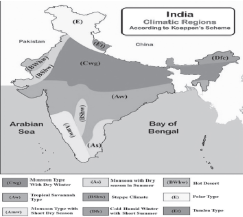
Climatic Regions of India
India’s climate is notably diverse, shaped by its vast latitudinal range, the Himalayas to the north, and the Indian Ocean to the south. This diversity results in varied temperature and precipitation patterns across the country, leading to the identification of distinct climatic regions.
Koeppen’s Classification of Climatic Regions in India: Koeppen’s classification, based on temperature and precipitation, delineates India’s climate into several types:
| Climatic Type | Description | Location |
| Amw | Monsoon type with a short dry season | Western coastal region south of Goa |
| AS | Monsoon type with dry season in summers | Coromandel Coast |
| Aw | Tropical Savanna type | Almost the entire peninsular region excluding some coastal areas |
| BShw | Semi-arid steppe climate | Interior of the peninsular plateau, parts of Gujarat, Rajasthan, Haryana, Punjab, and Jammu & Kashmir |
| BWhw | Hot desert type | Western part of Rajasthan |
| Cwg | Monsoon type with dry winters | Majority of India’s northern plains |
| Dfc | Cold-humid winter type with short summer | North-eastern India |
| E | Polar type | Jammu and Kashmir and nearby mountain ranges |
Stamp’s Classification of Climatic Regions in India: Stamp’s classification divides India into two major climate zones using an isotherm of 18°C for the mean monthly temperature in January:
- Temperate or Continental Zone: Located in the north, roughly aligned with the Tropic of Cancer, indicating a division between the temperate north and tropical south.
- Tropical Zone: Found in the southern part of the country, this zone experiences a predominantly tropical climate.
Further, these major zones are subdivided into eleven regions based on specific temperature and rainfall criteria.
Temperate or Continental India
| Region | Average Temperature (°C) | Annual Rainfall |
| Himalayan Region | Summer: 4°-7°C Winter: 13°-18°C | East: Over 200 cm West: Much less |
| Northwestern Region (Northern parts of Jammu and Kashmir and Northern parts of Punjab) | Summer: 16°C Winter: 24°C | Below 200 cm |
| Arid Lowland (Thar Desert, southwestern Haryana, Kachchh in Gujarat) | Winter: 16°-24°C Summer: 48°C | Below 40 cm |
| Region of Moderate Rainfall (Punjab, Haryana, western Uttar Pradesh, Union Territory of Delhi, northwestern Plateau region of Madhya Pradesh, eastern Rajasthan) | Winter: 15°-18°C Summer: 33°-35°C | 40 to 80 cm |
| Transitional Zone (Bihar and Eastern Uttar Pradesh) | Winter: 15°-19°C Summer: 30°-35°C | 51-100 cm |
Tropical India
| Region | Average Temperature (°C) | Annual Rainfall |
| Region of Very Heavy Rainfall (Assam, Tripura, Mizoram, Meghalaya, Nagaland) | Winter: 18°C Summer: 32°-35°C | Over 200 cm |
| Region of Heavy Rainfall (Chhattisgarh, Jharkhand, Gangetic West Bengal, Odisha, coastal Andhra Pradesh) | Winter: 18°-24°C Summer: 29°-35°C | 100 – 200 cm |
| Region of Moderate Rainfall (Between the Western and Eastern Ghats) | Winter: 18°-24°C Summer: 32° | 50 -100 cm |
| Konkan Coast (From Mumbai to Goa) | Annual: 24°-27°C | Over 200 cm |
| Malabar Coast (From Goa to Kanyakumari) | Annual: 27°C | Over 250 cm |
| Tamil Nadu (Tamil Nadu and adjoining areas of Andhra Pradesh) | Annual: 24°C | 100 to 150 cm |
UPSC PREVIOUS YEAR QUESTIONS
1. Consider the following statements: (2022)
1. High clouds primarily reflect solar radiation and cool the surface of the Earth.
2. Low clouds have a high absorption of infrared radiation emanating from the Earth’s surface and thus cause a warming effect.
Which of the statements given above is/are correct?
(a) 1 only
(b) 2 only
(c) Both 1 and 2
(d) Neither 1 nor 2
2. Westerlies in the southern hemisphere are stronger and persistent than in northern hemisphere. Why? (2011)
1. Southern hemisphere has less landmass as compared to northern hemisphere.
2. Coriolis force is higher in southern hemisphere as compared to northern hemisphere
Which of the statements given above is/are correct?
(a) 1 only
(b) 2 only
(c) Both 1 and 2
(d) Neither 1 nor 2
3. What could be the main reason/reasons for the formation of the African and Eurasian desert belt? (2011)
1. It is located in the sub-tropical high-pressure cells.
2. It is under the influence of warm ocean currents.
Which of the statements given above is/are correct in this context?
(a) 1 only
(b) 2 only
(c) Both 1 and 2
(d) Neither 1 nor 2
4. The jet aircraft fly very easily and smoothly in the lower stratosphere. What could be the appropriate explanation? (2011)
1. There are no clouds or water vapour in the lower stratosphere.
2. There are no vertical winds in the lower stratosphere.
Which of the statements given above is/are correct in this context?
(a) 1 only
(b) 2 only
(c) Both 1 and 2
(d) Neither 1 nor 2
5. The 2004 Tsunami made people realize that mangroves can serve as a reliable safety hedge against coastal calamities. How do mangroves function as a safety hedge? (2011)
(a) The mangrove swamps separate the human settlements from the sea by a wide zone in which people neither live nor venture out
(b) The mangroves provide both food and medicines which people are in need of after any natural disaster.
(c) The mangrove trees are tall with dense canopies and serve as an excellent shelter during a cyclone or tsunami
(d) The mangrove trees do not get uprooted by storms and tides because of their extensive roots.
6. Which of the following is/are unique characteristic/characteristics of equatorial forests? (2013)
1. Presence of tall, closely set trees with crowns forming a continuous canopy
2. Coexistence of a large number of species
3. Presence of numerous varieties of epiphytes
Select the correct answer using the codes given below:
(a) 1 only
(b) 2 and 3 only
(c) 1 and 3 only
(d) 1, 2 and 3
7. During a thunderstorm, the thunder in the skies is produced by the: (2013)
1. Meeting of cumulonimbus clouds in the sky.
2. Lightning that separates the nimbus clouds.
3. Violent upward movement of air and water particles.
Select the correct answer using the codes given below:
(a) 1 only
(b) 2 and 3
(c) 1 and 3
(d) None of the above produces the thunder
8. The seasonal reversal of winds is the typical characteristic of (2014)
(a) Equatorial climate
(b) Mediterranean climate|
(c) Monsoon climate
(d) All of the above climates
9. In the South Atlantic and South-Eastern Pacific regions in tropical latitudes, cyclone does not originate. What is the reason? (2015)
(a) Sea surface temperatures are low
(b) Inter-tropical Convergence Zone seldom occurs
(c) Coriolis force is too weak
(d) Absence of land in those regions
10. Consider the following statements: (2015)
1. The winds which blow between 30 N and 60 S latitudes throughout the year are known as westerlies.|
2. The moist air masses that cause winter rains in North-Western region of India are part of westerlies.
Which of the statements given above is/are correct?
(a) 1 only
(b) 2 only
(c) Both 1 and 2
(d) Neither 1 nor 2
11. Why are dewdrops not formed on a cloudy night? (2019)
(a) Clouds absorb the radiation released from the Earth’s surface.
(b) Clouds reflect back the Earth’s radiation.
(c) The Earth’s surface would have low temperatures on cloudy nights.
(d) Clouds deflect the blowing wind to ground level.
12. Consider the following statements: (2020)
1. Jet streams occur in the Northern Hemisphere only.
2. Only some cyclones develop an eye.
3. The temperature inside the eye of a cyclone is nearly 10°C less than that of the surroundings.
Which of the statements given above is/are correct?
(a) 1 only
(b) 2 and 3 only
(c) 2 only
(d) 1 and 3 only