PHYSIOGRAPHY OF INDIA
Geographical Extent of India

- India’s geographical expanse and its positioning on the globe have significant implications for its climate, culture, and day-to-day life. This detailed overview explores the basics of India’s geography, including its latitudinal and longitudinal extent, its size in relation to the world, boundaries, and the importance of the Tropic of Cancer and the Indian Standard Meridian in defining its time zone and climatic patterns.
Location
- India is situated entirely in the Eastern Hemisphere of the Northern Hemisphere, showcasing its vastness and diversity.
Latitudinal and Longitudinal Spread
- The mainland stretches from latitudes 8°4’N to 37°6’N and longitudes 68°7’E to 97°25’E.
- North-South and East-West Extent: From Indira Col in the north to Kanyakumari in the south, India measures about 3,214 km. The east-west extent is approximately 2,933 km, from the Rann of Kutch in Gujarat to the eastern borders of Arunachal Pradesh.
India’s Global Positioning
- Seventh Largest Country: With an area of 32,87,263 square kilometers, India accounts for 2.4% of the world’s total surface area, making it the seventh-largest country globally.
- Land Boundary and Coastline: The total length of India’s land boundary is about 15,200 km, with a coastline of 7,516.6 km, including the mainland and the islands of Andaman and Nicobar and Lakshadweep.
Islands and Extremities
- Island Territories: The Andaman and Nicobar Islands in the Bay of Bengal and the Lakshadweep Islands in the Arabian Sea are integral parts of the country, extending India’s geographical domain.
- Southernmost Point: Indira Point (or Pygmalion Point) at 6°45’N latitude in the Andaman and Nicobar Islands is the southernmost point of India.
Tropic of Cancer
- Dividing Line: The Tropic of Cancer passes through the country at 23°30’N, almost dividing it into two equal parts and playing a crucial role in India’s climatic conditions.
- States it Passes Through: It traverses eight states, including Gujarat, Rajasthan, Madhya Pradesh, Chhattisgarh, Jharkhand, West Bengal, Tripura, and Mizoram.
Climatic Influence
- Tropical Country: Despite the temperate conditions in the north, India is predominantly tropical due to the monsoon’s dominance, the Himalayas acting as a barrier to cold northern air masses, and the predominance of tropical agriculture and settlements.
Standard Time Meridian
- IST Meridian: The Standard Time Meridian of India at 82°30′E longitude, passing through five states (Uttar Pradesh, Madhya Pradesh, Chhattisgarh, Odisha, and Andhra Pradesh), serves as the basis for Indian Standard Time (IST).
- Time Zone: IST is set at 5 hours and 30 minutes ahead of Greenwich Mean Time (GMT), unifying the nation under a single time zone despite its vast geographical spread.
India’s geographical characteristics not only define its physical boundaries and climatic conditions but also influence its cultural diversity, economic activities, and social interactions. The strategic positioning of the Tropic of Cancer and the Indian Standard Meridian are crucial for understanding the country’s climatic patterns and timekeeping system, further emphasizing the complex interplay between geography and daily life in India.
India’s political landscape is distinguished by its division into 28 states and 8 Union Territories, reflecting the country’s vast geographical, linguistic, cultural, and demographic diversity. This structure accommodates India’s status as the world’s largest democracy, embracing a wide range of diversities.
Indian States
| Sr. No. | State | Capital | Area (km²) |
| 1 | Rajasthan | Jaipur | 342,239 |
| 2 | Madhya Pradesh | Bhopal | 308,245 |
| 3 | Maharashtra | Mumbai | 307,713 |
| 4 | Uttar Pradesh | Lucknow | 240,928 |
| 5 | Gujarat | Gandhinagar | 196,024 |
| 6 | Karnataka | Bengaluru | 191,791 |
| 7 | Andhra Pradesh | Hyderabad (Amravati – proposed) | 162,968 |
| 8 | Odisha | Bhubaneshwar | 155,707 |
| 9 | Chhattisgarh | Raipur | 135,191 |
| 10 | Tamil Nadu | Chennai | 130,058 |
| 11 | Telangana | Hyderabad | 112,077 |
| 12 | Bihar | Patna | 94,163 |
| 13 | West Bengal | Kolkata | 88,752 |
| 14 | Arunachal Pradesh | Itanagar | 83,743 |
| 15 | Jharkhand | Ranchi | 79,714 |
| 16 | Assam | Dispur | 78,438 |
| 17 | Himachal Pradesh | Shimla (Dharamshala – winter capital) | 55,673 |
| 18 | Uttarakhand | Dehradun (Gairsain – summer capital) | 53,483 |
| 19 | Punjab | Chandigarh | 50,362 |
| 20 | Haryana | Chandigarh | 44,212 |
| 21 | Kerala | Thiruvananthapuram | 38,863 |
| 22 | Meghalaya | Shillong | 22,429 |
| 23 | Manipur | Imphal | 22,327 |
| 24 | Mizoram | Aizawl | 21,081 |
| 25 | Nagaland | Kohima | 16,579 |
| 26 | Tripura | Agartala | 10,486 |
| 27 | Sikkim | Gangtok | 7,096 |
| 28 | Goa | Panaji | 3,702 |
Union Territories
| Sr. No. | Union Territory | Capital | Area (km²) |
| 1 | Jammu and Kashmir | Srinagar (May-Oct), Jammu (Nov-Apr) | 125,535 |
| 2 | Ladakh | Leh | 96,701 |
| 3 | Andaman and Nicobar Island | Port Blair | 8,249 |
| 4 | National Capital Territory of Delhi | New Delhi | 1,484 |
| 5 | Dadra and Nagar Haveli & Daman and Diu | Daman | 603 |
| 6 | Puducherry | Puducherry | 479 |
| 7 | Chandigarh | Chandigarh | 114 |
| 8 | Lakshadweep | Kavaratti | 26.23 |
The geopolitical and cultural fabric of India is rich and complex, shaped significantly by its unique geography and historical interactions.
Boundary Sharing of States
- Uttar Pradesh stands out for sharing its borders with the highest number of states (8) and a Union Territory (Delhi).
- Assam and Chhattisgarh each share boundaries with 7 states, illustrating their central placement and connectivity within the nation.
- Maharashtra and Karnataka are bordered by 6 states each, further highlighting the interconnectedness of India’s states.
- Meghalaya and Sikkim, in contrast, share their borders with only one state each, underscoring their geographical distinctiveness.
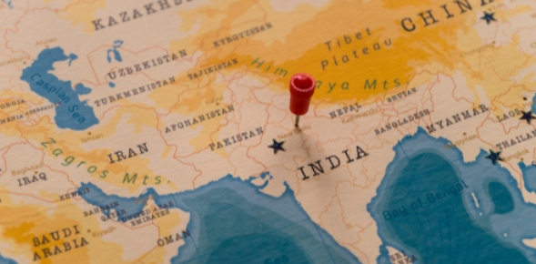
India as a Subcontinent and Its Significance
- Geological and Geographical Identity: India is considered a subcontinent due to its geological drift from Gondwanaland and its geographical peninsular shape in South-central Asia.
- Natural Boundaries: The Himalayas, Karakoram, and Hindu Kush mountains to the north, and the Indian Ocean, Arabian Sea, and Bay of Bengal to the south and east, respectively, delineate the subcontinent.
- Comprising Countries: The Indian subcontinent includes India, Pakistan, Nepal, Bhutan, Bangladesh, Sri Lanka, and the Maldives, making it a region of immense cultural, linguistic, and historical commonality.
Significance of India’s Location
- Historical Significance:
- The Himalayas and vast southern oceans have historically protected India from invasions, fostering a unique cultural identity.
- Invaders who reached India often settled, enriching its cultural, artistic, and traditional diversity, as seen with the Mughals and Europeans.
- Economic Significance:
- India’s diverse climate and topography have nurtured a wide variety of flora and fauna, contributing to its status as one of the world’s most biodiverse countries.
- This diversity extends to agricultural practices, enabling the cultivation of both temperate and tropical crops.
- Strategically located in the Indian Ocean, India controls key maritime routes, enhancing its trade relations with various regions since ancient times.
- Mountain passes have historically facilitated trade and cultural exchanges, serving as conduits for travelers and ideas across continents.
India’s geographical location and the shared boundaries of its states not only define its physical and political landscape but also enrich its cultural tapestry and economic potential. The country’s position as a subcontinent further emphasizes its unique place in the world, characterized by a rich history of protection, cultural fusion, and strategic economic advantages.
Geological Structure of India
India’s geological structure is a testament to its dynamic and complex geological history, marked by significant events that have shaped the subcontinent’s landscape. Understanding this geological history provides insights into the natural resources, terrain, and hazards of the region.
Major Events in the Geological History of India
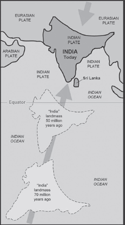
- Northward Movement of the Indian Plate: India was originally a part of the ancient supercontinent of Gondwanaland. The northward drift of the Indian plate, which began approximately 140 million years ago, is one of the most significant events in India’s geological history. This movement led to its collision with the Eurasian plate.
- The Upheaval of the Himalayas: The collision between the Indian and Eurasian plates, particularly during the Tertiary period, resulted in the formation of the Himalayas. This mountain range is among the youngest and is still rising as the Indian plate continues to move northward.
- Aggradational Formation of the Indo-Gangetic Plain: During the Pleistocene period, the formation of the Indo-Gangetic Plain began and continues to this day. The vast alluvial plain has been formed by the sedimentation brought by the Ganga River and its tributaries, making it one of the most fertile regions in India.
Classification of the Rock System in India
- Archaean Rock System
- Purana Rock System
- Dravidian Rock System
- Aryan Rock System
Each of these systems represents a significant phase in the geological timeline of India, encompassing different types of rocks and formations.
Archaean Rock System
The Archaean rock system is the oldest, dating back to the Pre-Cambrian era. It forms the foundation of the Indian subcontinent:
- Origin: The term ‘Archaean’ was coined by J.D. Dana in 1872 to denote the oldest rocks on Earth. These rocks formed from the cooling and solidification of the earth’s upper crust.
- Significance: The Archaean rock system forms the core of the Indian Craton, a stable and ancient part of the Earth’s lithosphere that was once part of Gondwanaland. This system is primarily composed of metamorphic rocks, which are indicative of the Earth’s early crustal development.
- Sub-systems:
- Archaean Gneisses and Schists System
- Dharwar Rock System
Archaean Gneisses and Schists System
| Characteristic | Details |
| Age | Approximately 4 billion years old, from the Pre-Cambrian era. |
| Type of Rocks | Primarily igneous, including granite gneisses and gabbro; and metamorphic schists like mica, chlorite, and talc. |
| Features | Azoic (un-fossiliferous), foliated, and crystalline plutonic intrusions. |
| Mineral Content | Rich in metallic and non-metallic minerals such as iron, manganese, copper, bauxite, gold, lead, and mica. |
| Exposure | Exposed at the surface in areas like the Aravalli hills, Deccan plateau, and northeast India due to erosion. |
| Distribution | Covers two-thirds of peninsular India and is found at the roots of the Greater Himalayas, Trans-Himalayas ranges including Karakoram, Ladakh, and Zaskar. |
Dharwar Rock System
| Characteristic | Details |
| Age | Formed between 2.5 billion to 1.8 billion years ago. |
| Discovery Location | Named after the Dharwar region of Karnataka; however, widespread across India. |
| Main Locations | Found in the Aravalli range, Chhotanagpur plateau, Meghalaya, and Tamil Nadu. |
| Mineral Content | Contains valuable minerals like iron ore, manganese, copper, and lead. |
| Series Classification | Divided based on location and mineral content: Champion series in Kolar (gold), Champaner series in Baroda (marble), and Chilpi series in Balaghat (copper), among others. |
Purana Rock System
- The Purana Rock System is a significant geological formation in India, encompassing two main systems: the Cuddapah Rock System and the Vindhyan Rock System. These systems, formed between 1400 and 600 million years ago, are primarily sedimentary, resulting from the erosion and deposition of older Archaean and Dharwar rocks.
Cuddapah Rock System
| Characteristic | Description |
| Formation | Composed of sedimentary rocks like sandstone, limestone, and clay deposited in synclinal folds. |
| Location | Predominantly observed in Cuddapah district of Andhra Pradesh. Also found in Delhi, Rajasthan, Chhattisgarh, etc. |
| Rock Types | Includes metamorphic rocks such as shale, slate, quartzite, and cement-grade limestone. |
| Distribution | Across Andhra Pradesh, southern Chhattisgarh, Odisha, and along the main axis of the Aravallis. |
| Economic Significance | Rich in minerals used for construction and manufacturing, like cement-grade limestone, slate, and quartzite. |
Vindhyan Rock System
| Characteristic | Description |
| Formation | Consists of ancient sedimentary rocks, approximately 4000m thick, superimposed on an Archaean base. |
| Location | Covers areas from Sasaram in Bihar to Chittorgarh in Rajasthan, excluding the central tract of Bundelkhand gneiss. |
| Rock Types | Known for red sandstone, sandstone, and durable stones. Contains ornamental stones and limestone. |
| Distribution | Extends from Sasaram (Bihar) to Chittorgarh (Rajasthan), excluding central Bundelkhand gneiss. |
| Economic Significance | Provides a large quantity of ornamental and durable stones, limestone for lime, glass, cement, and chemical industries. Known for diamond-bearing regions like Panna and Golconda. |
Dravidian Rock System
Characterized by the presence of coal-bearing Gondwana sediments and the volcanic Deccan Traps, which have played a crucial role in India’s geological and economic history.
| Feature | Details |
| Formation Era | Palaeozoic era, approximately 600-300 million years ago. |
| Significance | Known for marking the beginning of coal formation and the emergence of life, offering varied fossil evidence. |
| Location | Predominantly found in the extra-peninsular region of the Himalayas and the Gangetic plain, with minor presence in the Peninsular shield of Umaria in Rewa. |
| Geological Stages Included | – Cambrian System
– Ordovician System – Silurian System – Devonian System (noted for fossils & corals) – Carboniferous System (noted for lower & middle carboniferous layers) |
| Miscellaneous Note | The term “Dravidian” does not imply exclusivity to South India but is a geological term. |
Carboniferous Rock System
| Feature | Details |
| Formation Period | Formed around 350 million years ago. |
| Composition | Mainly composed of limestone, shale, and quartzite. |
| Significance | The term “Carboniferous” denotes coal-bearing, highlighting the era’s significance in coal formation. |
| Examples | High-quality coal from the Great Lakes region of the USA, Ruhr region of Europe, and the UK are Carboniferous. |
| Unique Fact | Mount Everest, the world’s highest peak, is composed of Upper Carboniferous limestone. |
The Dravidian and Carboniferous rock systems collectively underline the geological diversity and richness of Earth’s history. While the Dravidian rock system encompasses a broader range of geological stages and signifies the dawn of life and coal formation, the Carboniferous system specifically emphasizes the era’s pivotal role in developing significant coal deposits. These systems not only provide insight into the Earth’s past climates and biological evolution but also highlight regions of economic interest due to their resource deposits.
Aryan rock system
- The Aryan rock system, formed after the Carboniferous period, encompasses a broad classification of geological formations across different eras.
| Rock System | Formation Period | Features | Geographical Locations |
| Gondwana Rock System | Permian period (~250 million years ago) | Development in synclinal troughs, primary source of Gondwana coal, rich in metallic minerals. | Ranigunj, Jharia, Damodar valley, Pench valley, Godavari valley, Rajmahal hills. |
| Jurassic Rock System | Jurassic period | Marked by marine transgression, occurrence of limestone, sandstone, conglomerates, and shales. | Rajasthan and Kutch. |
| Deccan System or Deccan Trap | End of Mesozoic era | Formed due to volcanic outburst, basaltic lava flows, formation of black soil (Regur), divided into Upper, Middle, Lower Trap. | Kachchh, Saurashtra, Maharashtra, Malwa plateau, northern Karnataka. |
| Tertiary Rock System | Tertiary epoch | Characterized by the breaking up of Gondwanaland, upliftment of Himalayas, divided into Eocene, Oligocene, Miocene, Pliocene. | Karewas of Kashmir, Bhangar and Khadar of Gangetic plains, outer Himalayan region, Assam, Sind, Baluchistan. |
This classification provides a comprehensive overview of the geological evolution of the Indian subcontinent, highlighting significant periods of formation, the development of various rock systems, and their impact on the region’s physiography and mineral resources.
Quaternary Rock System
- The Quaternary period, the most recent in the geological timeline, encompasses the Pleistocene and the Holocene epochs. This period is characterized by significant geological and climatic changes that have shaped the Earth’s surface and influenced human evolution and civilization. The Quaternary rock system includes deposits from these epochs, providing key insights into Earth’s recent geological past and current environmental processes.
Characteristics of the Quaternary Rock System
- Deposits: It includes Pleistocene and recent (Holocene) deposits such as Bangar (old alluvial soil) and Khadar (new alluvial soil). These alluvial deposits are particularly significant in the Indo-Gangetic plains, contributing to the region’s fertility.
- Formation of Karewas: Continuous deposition in the Kashmir valley during this period led to the formation of Karewas, which are lacustrine deposits known for their agricultural importance and the presence of fossil remains.
- Thar Desert and Rann of Kutch: Depositions from the Quaternary period are also found in the Thar Desert. Moreover, the development of the Rann of Kutch, which was part of the ocean, was significantly influenced by sedimentary deposits during this period, indicating a complex interaction between marine and terrestrial environments.
Marine Transgression
- Definition: Marine transgression is a geological event during which the sea level rises relative to the land, causing the shoreline to move toward higher ground. This can result in flooding and significant changes in coastal and inland ecosystems.
- Causes: It can be caused by the land sinking (subsidence) or by the ocean basins filling with water (due to glacier melt, for example) or decreasing their capacity (due to tectonic activities).
Meghalaya Age
- Definition: The latest part of the Holocene age, known as the Meghalaya Age, began around 4,200 years ago. It is marked by an abrupt mega drought that significantly impacted several ancient civilizations across the globe.
- Impact on Civilizations: This period witnessed the collapse of civilizations in regions such as Egypt, Greece, Syria, Palestine, Mesopotamia, the Indus Valley, and the Yangtze River Valley, highlighting the profound influence of climatic changes on human societies.
- Evidence: The evidence supporting the onset of the Meghalaya Age was found in the Mawmluh caves of Meghalaya, providing crucial insights into the climatic conditions of the time.
Physiographic Units of India
- India’s diverse physiography, ranging from the towering Himalayas to the vast Thar Desert, is a result of its complex geological and climatic history. The country is divided into several physiographic units, each with its unique characteristics and formation processes.
The Himalayas
- Characteristics: The Himalayas, the world’s highest and young fold mountain range, were formed by the collision of the Indian plate with the Eurasian plate. Covering around 10.7% of India’s land area, the Himalayas stretch across 2400 km from west to east, with their width varying significantly.
- Formation: The formation of the Himalayas began around 70 million years ago as the Indian plate moved northward towards the Eurasian plate. The ongoing convergence of these plates led to the folding of sediments between them, creating the Himalayas. This process continues today, making the Himalayas a region of high tectonic activity, as evidenced by frequent earthquakes and the ongoing rise of the mountain range.
Syntaxial Bends
- The Himalayas feature syntaxial bends at both ends – the western bend near Nanga Parbat and the eastern bend near Namcha Barwa. These bends are significant geological features resulting from the complex tectonic forces at play during the formation of the Himalayas.
Youthful Nature of Himalayan Rivers
- Vertical Erosion and V-Shaped Valleys: The youthful nature of Himalayan rivers is characterized by high vertical erosion rates and the formation of deep V-shaped valleys. This geomorphological feature indicates active down-cutting into the mountainous terrain, suggesting that the Himalayas are still rising.
- Balancing Act: While tectonic uplift forces are causing the Himalayas to rise, the forces of weathering and erosion are simultaneously working to lower them, maintaining a delicate balance in the mountain range’s elevation.
- New Height Measurement: Recent official declarations by Nepal and China have updated Mount Everest’s height to 8,848.86 meters (29,031.69 feet) above sea level, reaffirming its status as the highest point on Earth.

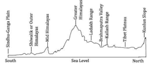
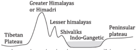
Division of the Himalayas
- The Himalayan Mountain Range is broadly categorized into lateral and longitudinal divisions, each comprising several distinct ranges with unique characteristics.
- Lateral Division
- Trans-Himalayan Ranges: Located north of the Great Himalayas, extending into Tibet.
- Great Himalayas (Himadri): The highest range, containing the majority of the highest peaks, including Mount Everest and K2.
- Middle Himalayas (Himachal): Known for popular hill stations and valleys, situated south of the Himadri.
- Outer Himalayas (Shiwalik): The southernmost range, known for its lower elevations and younger geological formations.

- Longitudinal Division
- Western Himalayas: Includes the Kashmir or Punjab Himalayas and Kumon Himalayas, characterized by significant snowfall and several high peaks.
- Central Himalayas (Nepal Himalayas): Home to the highest peaks, including Mount Everest and Kanchenjunga.
- Eastern Himalayas (Assam Himalayas): Stretching into the northeastern part of India and Bhutan, known for high biodiversity and heavy rainfall.
- Significant Features of the Himalayas
- Width Variation: The Himalayas are wider in the west (about 400 km in Kashmir) than in the east (about 150 km in Arunachal Pradesh), attributed to greater compressive forces in the east.
- Slope Steepness: The southern slope facing India is steeper compared to the northern slope facing Tibet, impacting climate and river flow.
- Glacial Presence: Containing some of the largest glaciers outside the polar regions, the Himalayas are often referred to as the “Third Pole of Earth.” Notable glaciers include Gangotri and Yamunotri.
- Perennial Rivers: The Himalayas are the source of major river systems, including the Indus, Ganga, and Brahmaputra, which are perennial due to glacial and monsoon contributions.
- Freshwater Lakes: The range boasts numerous high-altitude freshwater lakes, such as Tilicho, Pangong Tso, and Yamdrok Tso, adding to its geographical and ecological diversity.
The Himalayas play a crucial role in shaping the climate, hydrology, and ecology of the South Asian region. Their dynamic geological activity continues to shape the landscape, offering insights into the processes that govern the Earth’s surface. Understanding the Himalayas’ complex structure and features is essential for addressing the challenges of climate change, biodiversity conservation, and sustainable development in the region.
Lateral Division of the Himalayas
Trans-Himalayan Range
| Range | Characteristics |
| Karakoram Range | Northernmost range of the Trans-Himalayas, known as Krishnagiri.
Houses the world’s 3rd largest and the largest non-polar glacier. K2 (Godwin Austen Peak), the world’s second-highest peak, is located here. |
| Ladakh Range | Lies south of the Karakoram Range, merging with the Kailash range in Tibet. |
| Zaskar Range | Positioned between the Ladakh Range and the Great Himalayas.
Nanga Parbat marks the north-western end of this range. |
| Kailash Range | Also known as the Gangdise Range, located in Tibet.
Mount Kailash, revered in several religions, is a prominent peak. Features include Helmet Top, Gurung Hill, and the strategic Chushul Bowl. |
| Pamir Knot | A confluence of major mountain ranges: Tian Shan, Karakoram, Kunlun Shan, Hindukush, and the Pamir system.
Located in eastern Tajikistan. |
The Great Himalayas – Himadri
| Characteristic | Description |
| Formation | The northernmost and highest range with an average height of 6000m. |
| Features | Peaks perennially covered with snow.
Separated from the Lesser Himalayas by the Main Central Thrust (MCT). |
| Prominent Peaks | Includes Mt. Everest (8848m) and Mt. Kanchenjunga (8598m). |
| Glaciers | Home to many glaciers like Gangotri, Satopanth, Yamunotri, Siachen, and Aksai Chin. |
| Mountain Passes | Includes Bara-Lacha La, Shipki La, Nathu La, Zoji La, Bomdi La, and Rohtang La. |
The Lesser Himalayas – Himachal Range
| Characteristic | Description |
| Formation | Known as Middle, Inner, or Lower Himalayas, situated between the Great Himalayas and the Shiwaliks. |
| Dimensions | Width ranges from 60-80 km.
Average height varies from 1300-4500m. |
| Separation | Separated from the Shiwaliks by the Main Boundary Thrust (MBT). |
| Terrain | Steep and barren southern slope; the northern slope is gentle and forested. |
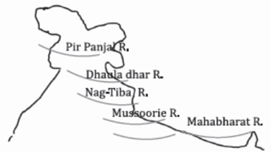
| Notable Ranges | Includes the Pir Panjal (South of Kashmir valley), Dhauladhar (Himachal Pradesh), Mussoorie and Nag Tibba (Uttarakhand), and Mahabharata (Nepal) ranges. |
| Human Interaction | Hosts various hill stations like Shimla, Mussoorie, and Nainital, and valleys like Kashmir, Kullu, and Kangra, making it more hospitable for human habitation. |
These divisions of the Himalayas showcase the diversity and grandeur of this mountain range, highlighting its geological complexity and the profound impact it has on the surrounding landscapes, climates, and cultures.
The Himalayan Range, with its complex geology and breathtaking landscapes, includes several notable sub-ranges that play a significant role in the geography, culture, and ecology of the region.
| Range | Location | Description |
| Pir Panjal Range | Jammu and Kashmir | Part of the western Himalayas.
Extends over 300 km from the Nilam River to the upper Beas River. Elevation varies from 1,400 m to 4,100 m. Contains volcanic rocks. Highest Peak: Mani Mahesh Kailash Peak. Features Karewas lacustrine deposits and is known for saffron cultivation. Notable passes include Banihal Pass and Pir Panjal Pass. |
| Dhaula-Dhar Range | Himachal Pradesh | A continuation of the Pir Panjal range.
Extends from Kangra and Mandi to near Badrinath, Uttarakhand. Elevation ranges from 3,500 m to 6,000 m. Composed mainly of granite, with areas of limestone and sandstone. Highest Peak: Hanuman Tibba. Features Lam Dal Lake and the Indrahar Pass. |
| The Mussoorie Range and The Nag-Tibba Range | Uttarakhand | Nag Tibba is the highest peak in Uttarakhand’s lesser Himalayas.
Known for its high-altitude meadows (Bugyals). Located on the foothills of the Garhwal Himalayas, northeast of Mussoorie. |
| Mahabharat Range | Nepal | Features the highest peak, Mount Kailash (6,714m), although Mount Kailash is traditionally located in Tibet, indicating possible confusion with local peaks.
Elevation ranges from 3,500 m to 6,000 m. Characterized by steep and jagged topography. |
These ranges not only define the physical landscape of the Himalayan region but also contribute significantly to the biodiversity, climatic conditions, and cultural heritage of the areas they span. They offer challenging terrains for trekkers and mountaineers, host diverse flora and fauna, and provide vital resources for the local populations.
Kashmir Valley
- The Kashmir Valley, a gem in the northern part of the Indian subcontinent, is nestled between the Pir Panjal Range and the Zanskar Range. It is renowned for its rich lacustrine deposits known as Karewas, which have shaped the valley’s agriculture and landscape.
- Geography: Lies between the Pir Panjal Range and Zaskar Range.
- Karewas: Lacustrine deposits crucial for agriculture.
- Agriculture: Notable for the cultivation of saffron (Zafran), apples, peaches, almonds, walnuts, and apricots.
- Geological Features: The valley’s basin is filled with alluvial, lake, and glacial deposits.
- Water Bodies: The Jhelum river traverses the valley, flowing through Wular Lake, India’s largest freshwater lake.
The Outer Himalayas – Shivalik Range
- The Outer Himalayas, or the Shivalik Range, represent the southernmost and youngest range of the Himalayan Mountain system, marking the natural boundary between the Himalayan foothills and the great plains.
- Location: Between the Lesser Himalayas and the great plains.
- Extent: Width ranges from 10-50 km; height varies between 900-1100 m.
- Geology: Composed mainly of sandstone and conglomerate rock formations.
- Features: Separated from the plains by the Himalayan Front Fault. Features Bhabar at the foothills, transitioning to nearly plain levels.
- Sub-ranges: Includes Dundwa Range, Margalla Hills, and Shivalik Fossil Park.
- Duns: Longitudinal valleys known as ‘Duns’ or ‘Duars’, e.g., Dehradun, Kotlidun, Patlidun, formed due to the collision of the Indian plate with the Eurasian plate.
Duns and Chos
- Duns: These are longitudinal valleys filled with coarse alluvium from Himalayan rivers, found between the Lesser Himalayas and Shivaliks. Famous duns include Dehradun, Kotli duns, and Patli duns.
- Chos: Characteristic of the eastern part of the Shivalik, these are highly dissected slopes by seasonal streams, especially noted in regions like Hoshiarpur district of Punjab. The southern slope of Shivalik in Punjab and Himachal Pradesh is nearly devoid of forest cover and is marked by these streams.
Shivalik Region
- The Shivalik Region, the southernmost range of the Himalayas, is known for its varied topography and geographical distribution across different states and countries.
| Name of Region | Location | Characteristics |
| Jammu Hills | Jammu Region | Part of the Shivalik range in Jammu, featuring lower hills and terrains conducive to agriculture and settlements. |
| Dafla, Miri, Abor, and Mishmi Hills | Arunachal Pradesh | These hills represent the eastern extension of the Shivalik range, featuring rich biodiversity and ethnic diversity. |
| Dhang range and Dundwa range | Uttarakhand | These ranges are part of the western Shivalik, known for their scenic beauty and pilgrimage sites. |
| Churia Ghat Hills | Nepal | Extending into Nepal, these hills are crucial for their forest resources and form a significant part of the Shivalik ecosystem. |
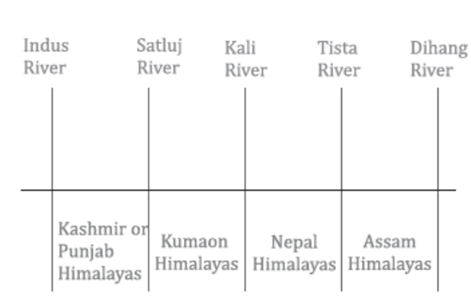
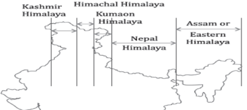
Longitudinal Division of the Himalayas: The Himalayas, extending from west to east, are divided into distinct regions based on geographical and geological characteristics:
Kashmir or Punjab Himalayas
| Feature | Details |
| Location | Between the Indus River and the Satluj River |
| Length | Approximately 560 km |
| Major Rivers | Indus River system |
| Classification | Divided into Kashmir Himalayas and Himachal Himalayas |
| Major Ranges | Karakoram, Ladakh, Pir Panjal, Zaskar, and Dhaola Dhar |
| Significant Aspects | Famous for Karewa formations and cultivation of saffron; home to important glaciers like Siachen. |
Kumaon Himalayas
| Feature | Details |
| Location | Between the Satluj River and the Kali River |
| Length | Approximately 320 km |
| Division | Western part known as Garhwal Himalayas and eastern as Kumaon Himalayas |
| Major Peaks | Nanda Devi, Kamet, Trisul, Badrinath, Kedarnath, Gangotri |
| Passes | Thang la, Mana Pass, Lipu lekh, Niti la |
Nepal Himalayas
| Feature | Details |
| Location | Between the river Kali and the river Tista |
| Peaks | Mt. Everest, Mt. Kanchenjunga, Mt. Makalu, Annapurana, Dhaulagiri |
| Lesser Himalayas | Known as Mahabharata Lekh |
| Valleys | Kathmandu and Pokhara are significant lacustrine valleys |
Assam Himalayas
| Feature | Details |
| Location | Between the Tista River and Dihang/Brahmaputra River |
| Characteristics | Steep southern slope, gentle northern slope; noted for tea plantations and Duar formations. |
| Pass | Jelep la lies at the tri-junction of India-China-Bhutan. |
Purvanchal Hills
| Feature | Details |
| Extension | Eastward extension of the Himalayas, running north-south along the India-Myanmar border |
| Composition | Comprises Patkai Bum, Naga, Manipur, Barail, Garo-Khasi-Jaintia, and Mizo Hills |
| Geological Aspect | Composed of sedimentary rocks, covered with dense forest |
| Further Extension | Extends southwards up to Andaman and Nicobar Islands through Arakan Yoma, and even to the Indonesian archipelago |
The diverse and complex geographical and geological characteristics of the Shivalik Region and the longitudinal divisions of the Himalayas, highlighting their significance in terms of cultural, ecological, and geological aspects.
The Himalayas, spanning across the northern border of India, are not only a geographical marvel but also a climatic barrier and a biodiverse region. This mountain range is divided into the Western and Eastern Himalayas, each with distinct geographical features, climatic conditions, biodiversity levels, and socio-cultural impacts.
Comparison Between Western and Eastern Himalayas
| Aspect | Western Himalayas | Eastern Himalayas |
| Extent | Extends up to the west of the river Kali. | Eastward of river Kali, from the east of the Singalila range of Sikkim to the eastern boundary of the Himalayas. |
| Topography | High ranges are distant from the plains, with elevation increasing in stages. | Mountains rise abruptly from the plains, making peaks closely connected to the plains. |
| Rainfall | Receives one-fourth of the rainfall compared to the Eastern Himalayas. | Experiences heavy rainfall, contributing to rich biodiversity. |
| Snowline | Lower snowline, around 2500m ASL. | Higher snowline, approximately 3500m ASL. |
| Precipitation | Primarily receives snowfall. | Receives both rainfall and snowfall, affecting river flow and agriculture. |
| Biodiversity | Comparatively less due to lower precipitation and harsher temperatures. | High biodiversity due to moist climate and dense forests. |
| Snowline Factors | The snowline varies due to latitude increase from Kanchenjunga (28° N) to Karakoram (36° N), with lower latitudes having warmer temperatures and a higher snowline. | The snowline is higher in elevation, partly due to the greater compressive forces in the east. |
| Slope and Precipitation | The southern slope is steeper and receives more precipitation compared to the northern slope. | Similar pattern as the Western Himalayas but with even greater precipitation on the southern slopes. |
Important Himalayan Glaciers
| Name of Glacier | Location |
| Siachen | Eastern Karakoram range in the Himalayas |
| Fedchenko | Karakoram (Note: The table mentions it, but Fedchenko Glacier is actually located in Tajikistan, not the Himalayas) |
| Biafo | Karakoram |
| Baltoro | Karakoram |
| Gangotri | Kumaon-Garhwal |
| Zemu | Kanchenjunga-Everest |
Important Peaks in the Himalayan Mountains
| Peak Name | Height (meters) | Mountain Range | Country |
| Mount Everest | 8,848 | Himalayas | Nepal |
| Mt. Godwin Austin (K2) | 8,611 | Karakoram | Pakistan |
| Kangchenjunga | 8,586 | Himalayas | India, Nepal |
Important Valleys in the Himalayas
| State/Region | Valleys |
| Jammu and Kashmir | Kashmir, Betab, Chenab, Nubra, Suru, Indus, Mushkosh, Markha |
| Himachal Pradesh | Kullu, Kangra, Chamba, Karsog, Spiti, Lahaul, Sangla |
| Uttarakhand | Dun (Dehradun), Bhagirathi, Mandakini, Valley of Flowers |
| West Bengal | Neora Valley |
| Sikkim | Chumbi, Yumthang |
| Assam | Barak, Brahmaputra |
| Arunachal Pradesh | Dibang |
| Nagaland | Dzukou |
| Manipur | Kabaw, Imphal |
| Nepal | Kathmandu |
Significance of the Himalayas
- Influence on Climate
- Monsoon Regulation: Acts as a barrier to monsoon winds, causing significant rainfall in the Ganga-Brahmaputra plains.
- Temperature Moderation: Prevents cold Siberian winds from entering India, maintaining moderate temperatures.
- Jet Stream Influence: Affects the Subtropical Jet Stream, influencing the Indian monsoon.
- Strategic Significance
- Natural Defense: Serves as a formidable natural barrier protecting the subcontinent.
- Economic Significance
- Hydroelectric Potential: Offers vast potential for hydroelectricity due to its fast-flowing rivers.
- Mineral Resources: Contains valuable minerals like anthracite coal, copper, lead, and tungsten.
- Agricultural Significance: Suitable for diverse crop cultivation, including tea, saffron, and various fruits.
- Tourism Significance
- Hill Stations: Home to renowned hill stations and tourist centers like Srinagar, Shimla, and Darjeeling.
- Religious Sites: Hosts significant Hindu and Buddhist shrines, including Kedarnath and Ladakh monasteries.
- Environmental Significance
- Biodiversity Hotspot: One of India’s four biodiversity hotspots, with diverse flora and fauna.
Causes of Frequent Landslides in the Himalayas
- Physiographic Structure: Being young and fragile, the Himalayas are prone to landslides.
- Tectonic Activity: Ongoing tectonic movements contribute to landslides due to isostatic imbalances.
- Rock Structure: Composed of unconsolidated sedimentary rocks, making them susceptible to erosion.
- Steep Slopes: The sharp and steep slopes of the Himalayas increase the risk of landslides.
- Hydrological Forces: Rapidly flowing rivers contribute to significant erosion and denudation.
- Anthropogenic Activities: Infrastructure development in the region exacerbates landslide risks.
The Himalayas play a critical role in shaping the climate, culture, and economy of the surrounding regions. Their strategic location and natural resources make them invaluable, while their ecological diversity and beauty draw people from around the world. However, the fragility of this majestic mountain range calls for careful management and conservation to mitigate natural disasters and preserve its integrity for future generations.
The Indus-Ganga-Brahmaputra Plain
The Indus-Ganga-Brahmaputra Plain, also recognized as the Great Northern Plain, is one of the world’s largest and most fertile aggradation plains, marked by extensive alluvial deposits. This plain is a pivotal geographic and agricultural zone of India, playing a significant role in the country’s economy, particularly in agriculture.
Characteristics of the Indus-Ganga-Brahmaputra Plain
- Geographical Extent: Stretches approximately 2,400 km from west to east, spanning from Punjab to Assam, with varying widths—about 500 km in Punjab and narrowing to 90 km in Assam.
- Physiographic Feature: It is considered the youngest physiographic feature of India, highlighting its dynamic geological history.
- Boundaries:
- North: Bordered by the Himalayas.
- South: Bounded by the Peninsular Plateau.
- East: Enclosed by the Purvanchal Hills.
- West: Flanked by the Sulaiman and Kirthar ranges.
- Elevation: The plain’s average elevation is around 200 meters above sea level, with the highest elevation near Ambala at about 291 meters. This high point serves as the watershed between the Indus and Ganga river systems.
- Topographical Feature: Known for its extreme horizontality, the plain is characterized by its flat, expansive terrain, facilitating the widespread agricultural practices seen today.
Formation of the Northern Plain
- The formation of the Northern Plain is intricately linked to the geological upliftment of the Himalayas. This process led to the creation of a significant geographical depression known as the Indo-Gangetic trough, which lies between the Himalayas and the Peninsular Plateau. Over time, rivers originating from the Himalayas, including the Indus, Ganga, and Brahmaputra, flowed through this trough, depositing sediments. These alluvial deposits gradually filled the depression, transforming it into the extensive, fertile plain we see today.
- Depositional Feature: The accumulation of alluvial sediments over millennia has led to the creation of a monotonous depositional plain, which lacks significant topographical variation.
- Agricultural Significance: The fertility of the soil, combined with the plain’s flat terrain, makes it one of the most agriculturally productive regions of the world. It supports the cultivation of a wide variety of crops, contributing significantly to the food security of India.
- The Indus-Ganga-Brahmaputra Plain is not just a geographical feature but a vital lifeline for the Indian subcontinent. Its formation, characterized by the deposition of alluvial soils by three of the region’s major rivers, has created a vast, fertile expanse that supports a significant portion of India’s population through agriculture. The plain’s extensive agricultural productivity, coupled with its strategic geographical location, underscores its importance to India’s economy, culture, and history.
Physiographic Division of the Northern Plain
- The Northern Plain of India, a vast expanse of fertile land formed by the interplay of the mighty rivers descending from the Himalayas, is characterized by its varied sedimentary environments. This division highlights the unique geographical features and agricultural viability of each section within the plain.
Divisions and Characteristics
| Division | Characteristics | Agricultural Significance | Geographical Features |
| Bhabar | 6-8 km wide stretch along the foothills of the Shivalik; consists of gravels and pebbles. | Not suitable for agriculture due to large gravels and high porosity. | Porous region causing river streams to disappear. |
| Terai | 15-30 km wide, marshy, and forested stretch; rivers reemerge here. | Rich in nitrogen and organic matter; suitable for sugarcane, rice, wheat, etc. | Thickly forested, providing habitat for diverse fauna. |
| Bhangar | Older alluvial deposits forming terraces higher than the floodplain. | Contains calcareous concretion (Kankar); less fertile than Khadar. | Above flood limits, not renewed yearly, includes the Barind plains. |
| Khadar | New alluvial deposits along the riverbanks, renewed yearly by floods. | Highly fertile; suitable for intensive agriculture. | Known as ‘Betlands’ in Punjab, supports rich wildlife. |
| Delta Plain | Comprises old mud, new mud, and marsh in the deltaic region. | Extension of Khadar, fertile lands ideal for cultivation. | Uplands known as Chars and marshy areas as Bils. |
Regional Division of the Northern Plains
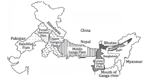
The Northern Plains are further classified based on geo-climatic conditions and regions into:
- Rajasthan Plain: Characterized by the Thar Desert and semi-arid regions, this plain has geological ties with the Peninsular plateau. The Luni river, an important seasonal river, marks this area.
- Punjab – Haryana Plain: Known as ‘the land of five waters’ due to the five rivers that traverse it, this area is rich in alluvial soil, making it highly fertile. The presence of doabs contributes to its agricultural productivity.
- Ganga Plain: Not detailed in the provided text, but known for its extensive coverage across several states, providing fertile land for numerous crops due to the sediments deposited by the Ganges and its tributaries.
- Brahmaputra Plain: While not detailed in the text, this plain is noted for its unique landscape shaped by the Brahmaputra River, featuring highly fertile lands, prone to floods but crucial for agriculture in the region.
The Ganga Plain
The Ganga Plain, an extensive tract of land formed by the alluvial deposits from the Ganga River and its tributaries, is one of the most fertile and densely populated regions of India. Stretching approximately 1400 km from west to east and with an average width of 300 km, it spans from the Yamuna catchment in the west to the Bangladesh border in the east. The contribution of peninsular rivers such as the Chambal, Betwa, Ken, Son, and others has been significant in its formation.
Classification of the Ganga Plain
- Upper Ganga Plain:
- Location: Includes the Ganga-Yamuna doab, Rohilkhand division, Awadh, and part of Agra division.
- Slope: Generally slopes towards the east and south-east.
- Agriculture: Known for the success of the Green Revolution, making it one of India’s most productive agricultural regions.
- Middle Ganga Plain:
- Location: Spans central and eastern Uttar Pradesh and extends into Bihar up to Muzaffarpur.
- Geology: Characterized by thick alluvial deposits with minimal Kankar (calcareous deposits) formation.
- River Dynamics: The low gradient of the region allows the river to frequently change its course; the River Kosi, known as the ‘Sorrow of Bihar’, is notorious for its meandering.
- Lower Ganga Plain:
- Location: Extends from Patna to the Bay of Bengal.
- Floods: Prone to frequent flooding, enriching the land with Khadar (new alluvial deposits).
- Economy: Dominated by rice cultivation and aquaculture due to the fertile soil.
Regional Division of Ganga Plain
- Rohilkhand Plains
- Avadh Plains
- Mithila Plains
- Magadh Plains
The Brahmaputra Plain
The easternmost part of the Indo-Gangetic Plains, the Brahmaputra Plain, stretches through the Assam Valley. It is flanked by the Lower Ganga Plain to the west and the Purvanchal Hills to the east.
- Formation: Developed by the sedimentary activities of the Brahmaputra River and its tributaries.
- Geography: Known for its low gradient, which leads to a highly braided river system and the formation of riverine islands like Majuli, the world’s largest riverine island.
- Agriculture: Major crops include jute and rice.
- Ganga-Brahmaputra Delta: This delta, the largest in the world, features the Sundarbans, a unique tidal forest ecosystem.
Significance of the Northern Plains
- Population: Houses about half of India’s population, covering one-fourth of the country’s land area.
- Agriculture: The fertile alluvial soil, coupled with a flat landscape, perennial rivers, and a favorable climate, supports extensive agricultural activities. Regions like Punjab, Haryana, and western Uttar Pradesh are known as the ‘Granaries of India’ due to their prolific grain production.
- Industrialisation and Urbanisation: An extensive network of railways and roadways facilitates significant industrial and urban development.
- Cultural Tourism: Home to many religious and historical sites along the banks of rivers such as the Yamuna and Ganga, including Haridwar, Varanasi, Gaya, Amritsar, etc., attracting millions of pilgrims and tourists annually.
The Northern Plains are thus a vital region for India, contributing significantly to its agricultural output, cultural heritage, and overall economic development.
Indian Peninsular Plateau
The Indian Peninsular Plateau, characterized by its roughly triangular shape, stands as one of the oldest and most stable landforms on the Indian subcontinent.
Geographic Boundaries and Features of the Peninsular Plateau
| Characteristic | Details |
| Shape and Stability | Roughly triangular, representing one of the oldest and most stable landmasses in India. |
| Composition | Composed predominantly of Archaean gneisses and schists. |
| Boundaries | Bordered by the Northern plains, Delhi ridge, Rajmahal Hills, Gir range, Western and Eastern Ghats, and the Shillong and Karbi-Anglong plateaus. |
| Area and Elevation | Covers about 16 lakh sq km with an average elevation of 600-900 m ASL. The general slope direction is from West to East. |
| River Flow | Peninsular rivers predominantly flow from west to east into the Bay of Bengal, with exceptions like the Narmada and Tapi flowing east to west. |
The Garo-Rajmahal Gap
| Feature | Description |
| Significance | Represents a physiographic gap due to alluvial deposits between the Garo and Rajmahal hills, creating a separation in the continuity of the Satpura range. |
| Geological Activity | Attributed to a fault created by the north-eastward movement of the Indian plate, which later got filled by riverine deposits. |
| Alternate Names | Also known as the Malda block or Malda Gap. |
Prominent Hill Ranges in the Peninsular Plateau
- Aravalli Range
- One of the world’s oldest mountain ranges, extending from Delhi to Ahmedabad.
- Features Guru Shikhar as its highest peak.
- Source of rivers like Banas, Luni, and Sabarmati.
- Vindhyan Range
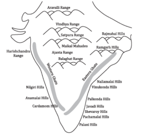
- Comprises block mountains like the Vindhyachal, Bhander, Kaimur, and Parasnath hills.
- Acts as a watershed divide between the Ganga system and the river systems of South India.
- Satpura Range
- Tectonic mountains formed by folding and uplift, running parallel to the Narmada and Tapti rivers.
- Includes Mahadeo hills, Maikala range, and Rajpipla hills, with Dhupgarh as the highest peak.
- Western Ghats
- Forms the western edge of the plateau, running parallel to the Arabian Sea across six states.
- Known for its abrupt rise from the western coastal plains, with a gentler slope on the eastern side.
Western Ghats
The Western Ghats, a UNESCO World Heritage Site, is one of the eight “hottest hotspots” of biological diversity in the world. Stretching approximately 1,600 km parallel to the western coast of the Indian Peninsula, it traverses through several states, featuring unique ecosystems, rich biodiversity, and significant geological formations. The Ghats can be divided into three main sections: the Northern, Middle, and Southern sections, each with distinctive characteristics.
Classification of the Western Ghats
| Section | Characteristics |
| Northern Section (Sahyadri) | Location: Maharashtra
Average Height: About 1200m ASL Main Rivers: Godavari, Bhima, Krishna Prominent Peaks: Kalasubai, Salher, Harishchandragarh Important Passes: Thal Ghat, Bhor Ghat |
| Middle Section | Location: Goa, Karnataka, terminating in the Nilgiris at the junction with the Eastern Ghats
Average Height: Around 1200m Prominent Peaks: Kudremukh, Pushpagiri Prominent Rivers: Tungabhadra, Cauvery Notable Features: Bababudan hills known for coffee plantations |
| Southern Section | Location: Comprises Annamalai hills and Cardamom hills
Notable Gaps: Palghat Gap, separating the Nilgiris from Annamalai hills Annamalai Hills Features: Anamudi Peak (highest in the Peninsula), origin of the Periyar river Cardamom Hills Features: Shenkottai Pass, Vaigai river origin Southernmost Point: Agasthyamalai hill in Kerala and Tamil Nadu |
Ecological and Geographical Significance
- Northern Section: This section is significant for its rugged terrain and serves as the source of major peninsular rivers, providing vital water resources and supporting diverse ecosystems.
- Middle Section: Characterized by its lush green landscapes, this section hosts some of the densest forests in the Ghats, supporting a wide range of plantations, including coffee and spices, contributing significantly to the region’s economy.
- Southern Section: Renowned for its high biodiversity, this section contains several endemic and endangered species of flora and fauna. The Palghat Gap plays a crucial role in influencing the regional climate, facilitating the monsoon winds’ entry into the peninsular interior.
Eastern Ghats
The Eastern Ghats, forming the eastern boundary of the Indian Peninsula, contrast significantly with the Western Ghats in terms of continuity, height, and geographical features.
Eastern Ghats: Features and Significance
- Geographical Position: The Eastern Ghats run parallel to the Bay of Bengal, marking the eastern edge of the Deccan Plateau.
- Extent: Stretching from the Mahanadi River in Odisha to the Vaigai River in Tamil Nadu, the Eastern Ghats cover a significant geographical area.
- Discontinuity and Height: Unlike the Western Ghats, the Eastern Ghats are discontinuous and generally lower in elevation. The highest peak in the Eastern Ghats is Jindhagada Peak, standing at 1,690 meters in the Araku Valley.
- Topographical Character: The northern part, between the Mahanadi and Godavari rivers, showcases true mountainous characteristics. However, the range becomes less discernible between the Godavari and Krishna rivers.
- Nallamala and Palkonda Ranges: The Nallamala Range, found in the Cuddapah and Kurnool districts of Andhra Pradesh, is a notable section of the Eastern Ghats. South of Nallamala lies the Palkonda Range.
- Southern Elevation: Towards the south, the elevation of the Eastern Ghats decreases, with the Javadi Hills and the Shevaroy Hills being notable exceptions, each reaching elevations around 1,000 meters.
- Confluence with Western Ghats: In the southern extremity, the Eastern Ghats merge with the Western Ghats.
- Key Peaks: Other significant peaks include Mahendragiri (1,501 m), Arma Konda (1,680 m), Gali Konda (1,643 m), and Sinkram Gutta (1,620 m).
Comparative Overview with Western Ghats
| Feature | Western Ghats | Eastern Ghats |
| Location | Western edge of the Deccan Plateau. | Eastern edge of the Deccan Plateau. |
| Continuity | Continuous range, crossed through passes. | Discontinuous and irregular, dissected by rivers. |
| Slope | Steep slope, height increases southward. | Gentler slope compared to Western Ghats. |
| Highest Peak | Anaimudi (2,695 m) | Jindhagada Peak (1,690 m) in the Eastern Ghats overall; Mahendragiri (1,501 m) as another notable peak. |
| Major Rivers | Narmada, Tapi, Sabarmati, Mahi, etc. | Mahanadi, Godavari, Krishna, Cauvery, etc. |
| Vegetation | Ranges from evergreen to deciduous forests. | Predominantly scrub vegetation due to overgrazing and deforestation. |
Plateaus of India
India’s landscape is dotted with numerous plateaus, each contributing to the country’s geographical diversity and richness.

Central Highlands
- Location: Basin of the Chambal River, through a rift valley.
- Features: Rolling plateau with rounded hills, primarily composed of sandstones.
- Significance: Known for the Ravines or Badlands of the Chambal River to the north.
Mewar and Marwar Plateau
- Location: Eastern Rajasthan, with Mewar east and Marwar west of the Aravalli.
- Elevation: Average of 250-500 meters above sea level.
- Features: Characterized by an eastward slope; drained by the Banas river.
Malwa Plateau
- Boundaries: Bounded by the Aravalli range, Madhya Bharat Plateau, and Bundelkhand.
- Drainage Systems: Towards the Arabian Sea (Narmada, Tapti, Mahi) and Bay of Bengal (Chambal, Betwa).
- Geology: Comprises Dharwar rocks, Vindhyan rocks, Gondwana rocks, and volcanic basaltic rocks; covered with black soil.
Bundelkhand Plateau
- Location: Between Yamuna to the north and Malwa plateau to the south.
- Geology: Made up of granite and gneiss rock; known for Bundelkhand gneiss.
- Features: Converted into an undulating plain by river erosion; unfit for cultivation.
Baghelkhand Plateau
- Geology: Composed of limestones, sandstones, and granite.
- Drainage: Bounded by the Son River in the north and the Mahanadi River system in the south.
- Elevation: Ranges from 150 to 1200 meters.
Chotanagpur Plateau
- Location: Covers parts of Jharkhand, northern Chhattisgarh, and Purulia district of West Bengal.
- Elevation: Average of 700 meters above sea level.
- Features: Composed of Gondwana rock system; major coal source; drained by numerous rivers forming a radial drainage pattern.
Meghalaya Plateau
- Extension: Eastward extension of the peninsular plateau beyond Rajmahal Hills.
- Features: Composed of Archaean quartzites, shale, schists with granite intrusion; separated from the Indian Peninsular plateau by Malda fault.
- Prominent Hills: Garo, Khasi, and Jainta hills.
Dandakaranya Plateau
- Location: Northeast of the Deccan plateau, covering parts of Chhattisgarh, Odisha, Telangana, Andhra Pradesh, and Maharashtra.
- Features: Thickly forested; drained by Mahanadi and Godavari rivers.
Deccan Plateau
- Boundaries: Bounded by the Satpura, Vindhyan ranges, and the Western and Eastern Ghats.
- Elevation: Average of 600 meters; slopes west to east.
- Subdivisions: Maharashtra plateau, Karnataka plateau, Telangana plateau.
- Subdivisions of Deccan Plateau
- Maharashtra Plateau: Northern part of Deccan, covered with basaltic rocks of lava origin; known for black soil.
- Karnataka Plateau (Mysore Plateau): South of Maharashtra plateau; divided into Malnad (dense forests) and Maidan (rolling plains).
- Telangana Plateau: Composed of Dharwar rocks, rich in minerals; divided into Ghats and Peneplains.
- Key Natural Resources
Black Soil:
a) Formation: Derived from the weathering of basaltic rocks of the Deccan Traps.
b) Composition: Rich in minerals such as iron, lime, aluminium, magnesium, and potassium.
c) Agricultural Use: Ideal for cultivating cotton, millets, tobacco, and citrus fruits due to its moisture-retentive properties.
2. Bauxite Reserves:
a) Location: Found in Jharkhand, Maharashtra, Madhya Pradesh, Chhattisgarh, Gujarat, Karnataka, Tamil Nadu, Goa, and Uttar Pradesh.
b) Use: Bauxite, the primary ore of aluminium, is crucial for the aluminum industry.
3. Iron Ore:
a) Significance: India is one of the largest producers of iron ore in Asia, with significant reserves located in Maharashtra and Goa.
b) Industrial Use: Essential for the steel industry.
4. Oil and Natural Gas:
a) Regions: Notable presence in parts of Telangana, Karnataka, and Maharashtra.
b) Energy Production: Vital for the energy sector, contributing to both domestic consumption and exports.
5. Geothermal Energy:
a) Potential: The Western Ghats offer geothermal potential, evidenced by numerous hot springs.
b) Renewable Energy: Represents a sustainable energy source with minimal environmental impact.
Chhattisgarh Plain
- Location: Lies between the Maikala range and the Odisha hills.
- Features: A saucer-shaped depression, primarily drained by the upper Mahanadi River.
- Elevation: General elevation ranges from 250 to 330 meters, with a west to east gradient.
Peninsular Plateau
- Significance of the Peninsular Plateau: The Peninsular Plateau is a region of immense economic and ecological importance, characterized by its mineral wealth, agricultural potential, forest resources, hydropower capabilities, and tourism attractions.
- Mineral Wealth: Home to 98% of India’s Gondwana coal deposits, and significant reserves of iron, copper, bauxite, and more. Notable regions include the Chhota Nagpur region (iron ore) and the Golconda region (gold).
- Agriculture: The north-western region’s fertile black lava soil is particularly suited for cotton cultivation, while hilly areas support tea, rubber, and coffee.
- Forest and Wildlife: The plateau’s diverse ecosystems range from evergreen to deciduous forests, supporting a wide array of flora and fauna.
- Hydropower Potential: Rivers originating from the Western Ghats offer significant hydroelectric potential and irrigation opportunities.
- Tourism: Renowned hill stations like Ooty, Pachmarhi, Mahabaleshwar, Khandala, and Matheran are located in this region, attracting tourists from across the globe.
The Himalayan Region vs. The Peninsular Plateau
| Aspect | The Himalayan Region | The Peninsular Plateau |
| Origin | Recent, formed by the collision of the Indian and Eurasian plates. | One of the oldest landmasses, part of Gondwanaland. |
| Geography | Characterized by lofty mountains and deep valleys. | Features rounded hills and broad, shallow valleys. |
| Geology | Comprised mainly of sedimentary rocks. | Consists of metamorphic and sedimentary rocks. |
| Tectonic Activity | Highly active, with the Himalayas still rising. | Relatively stable landmass. |
| Rivers | Hosts major rivers like the Indus, Ganga, Brahmaputra, and Yamuna. | Rivers include the Godavari, Krishna, Narmada, and Cauvery. |
| Hill Stations | Includes Shimla, Mussoorie, Darjeeling, Nainital, Kullu, etc. | Features Khandala, Ooty, Panchagni, Mahabaleshwar, etc. |
The Peninsular Plateau and the Himalayan Region, with their distinct geological formations and natural resources, play crucial roles in India’s geography, contributing to the country’s diversity in landscapes, ecosystems, and economic activities.
The Indian Desert
The Indian Desert, also known as the Thar Desert, forms a significant part of the north-western Indian subcontinent. It’s characterized by its arid conditions, unique ecosystem, and cultural richness. This desert not only marks the natural boundary between India and Pakistan but also plays a crucial role in the biodiversity and geology of the region.
Geographical Setting
- Location: Northwest of the Aravalli hills, spanning across Rajasthan and parts of Gujarat.
- Boundaries: Bordered by the Aravalli range, Punjab and Haryana, the Indus alluvial plain, and the Rann of Kutch.
- Area Coverage: Covers about 4.56% of India’s total geographical area, making it the 9th largest hot subtropical desert globally.
- Natural Boundary: Acts as a natural division between India and Pakistan, with around 15% lying in Pakistan.
Climatic Conditions
- Rainfall: Receives less than 150 mm of annual rainfall, leading to semi-arid and arid weather conditions.
- Ephemeral Rivers: The Luni River is the primary seasonal river, originating from the Pushkar valley of the Aravalli Range.
- Thali or Sandy Plains: Northern region of the Luni River, characterized by sandy terrains.
- Playas: Seasonal dry lakes that become brackish water sources, such as the Sambhar Lake.
Biodiversity
- Fauna (Species): Includes Blackbuck, Chinkara, Indian Wild Ass, Caracal, Red Fox, Peacock, Wolf, Sand Grouse, Leopard, and the Asiatic Wild Cat among others.
- Flora (Vegetation): Dominated by cactus, neem, khejri (Prosopis cineraria), acacia nilotica, and other desert-adapted plants.
Protected Areas in the Thar Desert
| Protected Area | Description |
| Desert National Park | One of the largest ecosystems in the Thar Desert, covering about 3162 km², known for its extensive flora and fauna. |
| Tal Chhapar Sanctuary | Spreads over 7 km² in Churu district, a haven for foxes, blackbuck, and partridge. |
| Sundha Mata Conservation Reserve | Encompasses 117.49 km² in Jalore District, focusing on conservation of the local ecosystem. |
| Lal Suhanra Biosphere Reserve (Pakistan) | A UNESCO declared biosphere reserve, showcasing the biodiversity of Pakistan’s portion of the Thar Desert. |
India’s coastal plains
India’s coastal plains, stretching along the 7516.6 km long coastline, including the coastlines of Indian islands, play a pivotal role in the country’s geography, economy, and culture. These plains are categorized into two distinct regions: the Eastern Coastal Plain and the Western Coastal Plain. Each of these regions possesses unique geographical features, ecosystems, and economic resources.

Comparison of Western and Eastern Coastal Plains
| Attribute | Western Coastal Plain | Eastern Coastal Plain |
| Location | Between the Western Ghats and the Arabian Sea | Between the Eastern Ghats and the Bay of Bengal |
| Extension | From the Gulf of Khambhat to Kanyakumari | From the Ganga Delta to Kanyakumari |
| Orientation | Parallel to the Western Ghats | Parallel to the Eastern Ghats |
| Type | Both submerged and emerged coastal plain | Emerged coastal plain |
| Width | Narrower and elongated | Broader than the western coast |
| Sub-Divisions | Kathiawar, Konkan, Kannada, and Malabar coasts | Utkal, Andhra, and Coromandel coasts |
| River Deltas | Rivers do not form significant deltas | Rivers form well-developed deltas |
| Natural Ports | Hosts significant natural ports like Kandla, JNPT, Marmagaon, Mangaluru, and Cochin | Fewer natural ports and harbors compared to the western coast |
Significance of India’s Coastlines
- Agriculture: Rice cultivation is predominant, with coconut trees lining the coastal areas.
- Economic Advantage: The coastlines facilitate approximately 95% of India’s trade by volume and 70% by value through major and minor ports.
- Mineral Resources: Coastal tracts, especially in Kerala, are rich in monazite sand, which is a source of nuclear fuel – thorium. Coastal sedimentary rocks are potential reserves for petroleum, shale gas, and natural gas.
- Tourism: Beaches along Maharashtra, Goa, and Kerala, and the Kerala backwaters, attract tourists globally, contributing significantly to the local and national economy.
- Blue Economy: Fishing is a major occupation, supporting livelihoods and contributing to the food security of the coastal population.
- Biodiversity: Coastal and marine ecosystems such as mangroves, estuaries, corals, and lagoons host rich biodiversity and serve as crucial sites for conservation and tourism.
The coastal plains of India are not just geographical entities but are integral to the nation’s cultural identity, economic development, and ecological balance. Their strategic importance for agriculture, trade, and biodiversity conservation underscores the need for sustainable management and preservation of these vital regions.
Indian Islands
India’s geographical diversity includes an extensive array of islands, ranging from the large archipelagos of Andaman and Nicobar in the Bay of Bengal and Lakshadweep in the Arabian Sea to minor islands scattered across coastal regions. These islands play a crucial role in India’s ecological system, culture, and defense.
Andaman and Nicobar Islands
- Location: At the juncture of the Bay of Bengal and the Andaman Sea.
- Composition: A group of 572 islands, with only 36 inhabited.
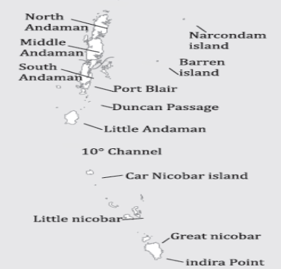
- Geology: Submerged volcanic mountains consisting of hard volcanic rocks.
- Separation: The 10 Degree Channel separates the Great Andaman group from the Nicobar group.
- Capital: Port Blair on South Andaman.
- Terrain: Comprises sandstone, shale, and limestone.
- Highest Peak: Saddle Peak (732 m) in North Andaman.

- Indigenous Tribes: Home to four ‘Negrito’ tribes – the Great Andamanese, Onge, Jarawa, and Sentinelese.
- Volcanic Activity: Contains Barren Island, India’s only active volcano.
Lakshadweep Islands
- Location: In the Arabian Sea, southwest of the Kerala coast.
- Composition: A group of 25 coral islands.
- Capital:
- Geographical Spread: Amindivi islands (northernmost) to Minicoy Island (southernmost).
- Vulnerability: Susceptible to rising sea levels due to their low elevation and coral nature.
- Island Groups: Divided into Amindivi islands, Laccadive islands, and Minicoy.
- Topography: Lacks hills, streams, valleys due to coral formation.
Notable Islands
- Majuli: World’s largest freshwater riverine island in the Brahmaputra River, also India’s first island district.
- Salsette: Hosts Mumbai, India’s most populous island.
- Sriharikota: Barrier island serving as ISRO’s satellite launching station.
- Aliabet: Site of India’s first offshore oil well, located off the coast of Gujarat in the Gulf of Khambat.
- New Moore Island (Purbasha): Located in the Sundarbans deltaic region, recently submerged due to rising sea levels.
- Pamban Island: Lies between India and Sri Lanka.
- Abdul Kalam Island: Formerly known as Wheeler Island, serves as a satellite launching station off the Odisha coast.
Renamed Islands
- Ross Island as Netaji Subhas Chandra Bose Dweep.
- Neil Island as Shaheed Dweep.
- Havelock Island as Swaraj Dweep.
Prominent Waterfalls in India
India, with its vast and varied topography, is home to numerous breathtaking waterfalls. Each waterfall, with its unique setting and features, adds to the natural beauty of its location.
Meghalaya
- Langshiang Fall: Third highest waterfall in India, located on the Kynshi River.
- Nohsingithiang Fall: Also known as the Seven Sisters’ Waterfall or Mawsmai Fall, situated in East Khasi Hills.
- Elephant Fall: Known locally as Ka Kshaid lai Pateng Khahsiew; named for a nearby elephant-shaped rock.
Jammu and Kashmir
- Aharbal Fall: Often referred to as the “Niagara Waterfall of Kashmir,” found on the Veshu River.
Himachal Pradesh
- Palani Fall: Among the highest surge waterfalls in India, positioned near Kullu.
Jharkhand
- Lodh Fall: Also known as Budha Ghagh; a 2-tiered waterfall within the Palamau Tiger Reserve.
Madhya Pradesh
- Dhuandhar Fall: A majestic waterfall in Madhya Pradesh.
- Apsara Fall: Known as Apsara Vihar or Fairy Pool Waterfall, located near Pachmarhi Hills.
- Kapildhara: Situated on the Narmada River, adding to the scenic beauty of the area.
Tamil Nadu
- Money Falls: A natural waterfall located in Coimbatore within the Annamalai hill range.
- Hogenakkai Fall: Found on the Cauvery River, showcasing nature’s splendor.
Karnataka
- Kunchikal Fall: The highest waterfall in India, positioned on the Varahi River.
- Shivasamudram Fall: A segmented waterfall on the Cauvery River, consisting of Gangana Chukki and Bhara Chukki falls.
- Jog Fall: The second-highest waterfall in India, situated on the Sharavathi River in the Western Ghats, on the border between Uttara Kannada and Sagara.
Goa
- Dudhsagar Fall: Located on the Mandovi River within the Bhagwan Mahaveer Sanctuary and Mollem National Park.
Chhattisgarh
- Teerathgarh Fall: Known as the “Queen of Satpura,” this block-type waterfall is a stunning sight.
Odisha
- Barehipani Fall: The second-highest waterfall in India, located in the Mayurbhanj district.
UPSC PREVIOUS YEAR QUESTIONS
1. Consider the following pairs: (2022)
| Reservoirs | States |
| 1. Ghataprabha | Telangana |
| 2. Gandhi Sagar | Madhya Pradesh |
| 3. Indira Sagar | Andhra Pradesh |
| 4. Maithon | Chhattisgarh |
How many pairs given above are not correctly matched?
(a) Only one pair
(b) Only two pairs
(c) Only three pairs
(d) All four pairs
2. Among the following States, which one has the most suitable climatic conditions for the cultivation of a large variety of orchids with minimum cost of production, and can develop an export oriented industry in this field? (2011)
(a) Andhra Pradesh
(b) Arunachal Pradesh
(c) Madhya Pradesh
(d) Uttar Pradesh
3. A state in India has the following characteristics: (2011)
1. Its northern part is arid and semi-arid.
2. Its central part produces cotton.
3. Cultivation of cash crops is predominant over food crops.
Which one of the following states has all of the above characteristics?
(a) Andhra Pradesh
(b) Gujarat
(c) Karnataka
(d) Tamil Nadu
4. When you travel in Himalayas, you will see the following: (2012)
1. Deep gorges
2. U-turn river courses
3. Parallel mountain ranges
4. Steep gradients causing land-sliding.
Which of the above can be said to be the evidence for Himalayas being young fold mountains?
(a) 1 and 2 only
(b) 1, 2 and 4 only
(c) 3 and 4 only
(d) 1, 2, 3 and 4
5. A particular State in India has the following characteristics: (2012)
1. It is located on the same latitude which passes through northern Rajasthan.
2. It has over 80% of its area under forest cover.
3. Over 12% of forest cover constitutes the Protected Area Network in this State.
Which one among the following States has all the above characteristics?
(a) Arunachal Pradesh
(b) Assam
(c) Himachal Pradesh
(d) Uttarakhand
6. With reference to the wetlands of India, consider the following statements: (2012)
1. The country’s total geographical area under the category of wetlands is recorded more in Gujarat as compared to other States.
2. In India, the total geographical area of coastal wetlands is larger than that of inland wetlands.
Which of the statements given above is/are correct?
(a) 1 only
(b) 2 only
(c) Both 1 and 2
(d) Neither 1 nor 2
7. Consider the following pairs:
| (2013) Tribe | States |
| 1. Limboo (Limbu) | Sikkim |
| 2. Karbi | Himachal Pradesh |
| 3. Dongaria Kondh | Odisha |
| 4. Bonda | Tamil Nadu |
Which of the above pairs are correctly matched?
(a) 1 and 3 only
(b) 2 and 4 only
(c) 1, 3 and 4 only
(d) 1, 2, 3 and 4
8. If you travel through the Himalayas, you are likely to see which of the following plants are naturally growing there? (2014)
1. Oak
2. Rhododendron
3. Sandalwood
Select the correct answer using the code given below.
(a) 1 and 2 only
(b) 3 only
(c) 1 and 3 only
(d) 1, 2 and 3
9. With reference to ‘Changpa’ community of India, consider the following statements: (2014)
They live mainly in the State of Uttarakhand
They rear the Pashmina goats that yield fine wool.
They are kept in the category of Scheduled Tribes.
Which of the statements given above is/are correct ?
(a) 1 only
(b) 2 and 3 only
(c) 3 only
(d) 1, 2 and 3
10. Which of the following have coral reefs? (2014)
Andaman and Nicobar Islands
Gulf of Kachchh
Gulf of Mannar
Sunderbans
Select the correct answer using the code given below.
(a) 1, 2 and 3 only
(b) 2 and 4 only
(c) 1 and 3 only
(d) 1, 2, 3 and 4
11. In India, in which one of the following types of forests is teak a dominant tree species? (2015)
(a) Tropical moist deciduous forest
(b) Tropical rainforest
(c) Tropical thorn scrub forest
(d) Temperate forest with Grasslands
12. In a particular region in India, the local people train the roots of living trees into robust bridges across the streams. As the time passes, these bridges become stronger. These unique ‘living root bridges’ are found in (2015)
(a) Meghalaya
(b) Himachal Pradesh
(c) Jharkhand
(d) Tamil Nadu
13. Consider the following States: (2015)
1. Arunachal Pradesh
2. Himachal Pradesh
3. Mizoram
In which of the above States do ‘Tropical Wet Evergreen Forests’ occur?
(a) 1 only
(b) 2 and 3 only
(c) 1 and 3 only
(d) 1, 2 and 3