DRAINAGE BASINS
Introduction
- Overview of Drainage Systems
Drainage systems represent the intricate networks through which water moves across various landscapes. These systems are fundamental in managing water collected from diverse sources such as snowfall, ice melt, rainfall, and floods. By channeling water through defined passages, drainage systems prevent flooding, manage water resources, and support ecosystems.
- Composition of a Drainage System
A drainage system consists of a series of channels, rivers, and streams that converge to direct water towards a larger body of water, such as an ocean or a lake. The system’s efficiency and directionality—whether it flows eastward or westward—are influenced by the area’s physical characteristics, including rock structure, slope gradient, water flow rate, and overall topography.
Factors Influencing Drainage Patterns
- Rock Structure: The composition and arrangement of rocks determine the system’s path, as water tends to flow along the path of least resistance.
- Slope: The angle of the land surface affects the speed and direction of water flow.
- Water Flow: The volume and speed of water moving through the system influence erosion and the system’s capacity.
- Topography: The landscape’s shape and features dictate the drainage pattern and potential water collection points.
Classification of Drainage Systems
- Large Rivers: Catchment areas of 20,000 square kilometers and above. These rivers are significant waterways capable of supporting extensive ecosystems and human settlements.
- Medium Rivers: Catchment areas ranging from 2,000 to 20,000 square kilometers. These rivers serve as important regional water sources and habitats.
- Small Rivers: Catchment areas of 2,000 square kilometers and below. Small rivers are often critical for local ecosystems and communities, providing water for agriculture, drinking, and recreation.
Types of drainage patterns based on the interaction between river flow and topography
- Discordant Drainage Patterns: Discordant drainage patterns emerge when rivers maintain their course regardless of the variations in topography and geology they encounter. These patterns suggest that the river’s path was established before the current landscape features were formed, or that the river has a significant ability to cut through the underlying terrain due to its power or the nature of the landscape’s geology. There are two main types within this category:
- Antecedent Drainage: Antecedent drainage occurs when a river maintains its original course and gradient even as the surrounding landscape is uplifted due to tectonic activities. Over time, this results in the river deepening its valley, often forming striking gorges as it continues to erode the landscape vertically. A classic example of antecedent drainage can be seen in the Himalayan rivers, such as the Sutlej and the Indus, which cut through the mountain ranges rather than altering their courses.
- Superinduced or Superimposed Drainage: In superinduced or superimposed drainage patterns, a river’s course is determined by the landscape’s initial topography and slope but remains unaffected by the types of surface rocks it encounters. This pattern indicates that the river predates the current surface and has cut down through newer geological layers, ignoring their characteristics. The flow and force of the river in these patterns are influenced by the hardness of rocks and the presence of faults. Examples include the Peninsular rivers of India, like the Damodar and the Chambal, which have carved their paths through the landscape irrespective of the surface rock types.
- Concordant Drainage Patterns: Concordant drainage patterns develop when the direction and behavior of a river are directly influenced by the landscape’s slope and topography. In these patterns, there is a harmonious relationship between the river’s path and the geological structure of the area. Concordant patterns are more common and typically result in rivers that follow the easiest path of descent. This category includes:
- Consequent Rivers: Consequent rivers flow directly downhill, following the slope of the land from their point of origin. These rivers essentially take the path of least resistance, often corresponding to the initial slope of the surface at the time of their formation. Rivers like the Godavari, Krishna, and Kaveri in India are examples of consequent rivers that have followed the natural incline of the terrain since their inception.
- Subsequent Rivers: Subsequent rivers develop as tributaries to consequent rivers, carving their paths through softer or more easily eroded materials revealed by the primary river’s flow. These rivers adjust their courses based on the erosion and deposition patterns established by the larger rivers, often leading to complex drainage systems. For instance, in India, rivers such as the Chambal, Sind, Ken, and Betwa have their courses determined by the erosion caused by the main rivers, flowing towards the Ganga and Yamuna from the Vindhya and Satpura ranges.
Types of drainage patterns based on the topography, geology, and climatic conditions
- Dendritic Pattern
- Description: This pattern resembles the branches of a tree, spreading out in various directions. It typically occurs in regions with uniform material, where river channels follow the path of least resistance.
- Examples: Godavari, Mahanadi rivers in India.

- Radial Pattern
- Description: Radiates outward from a central high point, like a volcano or a hill. Rivers flow away from the center in all directions, mimicking the way lava spreads from a volcano’s peak.
- Examples: Son and Narmada rivers, originating from the Amarkantak range.

- Centripetal Pattern
- Description: The opposite of the radial pattern, where streams flow towards a central point, such as a lake or depression. This pattern is characterized by inward-flowing watercourses.
- Examples: Loktak Lake in Manipur, streams in Ladakh.

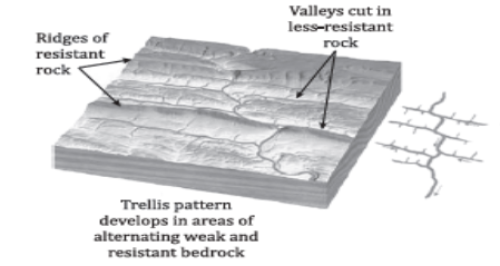
- Trellis Pattern
- Description: Occurs in regions with alternating bands of hard and soft rock. Main tributaries flow parallel to each other, while secondary tributaries join at right angles.
- Examples: Ganga and its tributaries, folded mountains of the Chhotanagpur plateau.
- Rectangular Pattern
- Description: Characterized by rivers that bend sharply due to a faulted and jointed rocky terrain, creating a pattern of right-angled turns.
- Examples: Tapi river.

- Parallel Pattern
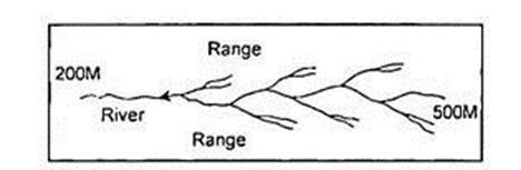
- Description: Found in regions with parallel slopes, where tributaries flow parallel to one another following the slope’s direction.
- Examples: Rivers originating from the Western Ghats, such as Godavari, Tungabhadra.
- Angular Pattern
- Description: Common in the Himalayan region, where tributaries join the main river at acute angles due to the rugged terrain.
- Examples: Not specified, but typical for rivers in steep, mountainous areas.

- Deranged Pattern
- Description: An uncoordinated pattern that occurs in areas previously covered by ice sheets, with no clear system, often found in glaciated landscapes.
- Examples: Glacier valleys of the Karakoram ranges.
- Barbed Pattern
- Description: Features tributaries that join the main river at an opposing direction, resembling barbs on a wire or fishhook.
- Examples: Arun river, a tributary of the Kosi river in Nepal.
- Pinnate Pattern
- Description: Resembles the structure of a feather, with tributaries joining the main river from steep mountainsides, similar to veins connecting to a nerve.
- Examples: Son and Narmada rivers.
- Braided Pattern
- Description: Formed in rivers with high sediment loads, characterized by multiple channels that divide and rejoin, creating an intertwined appearance.
- Examples: Brahmaputra river.

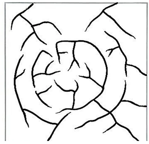
- Annular Pattern
- Description: Rare in India, this pattern features streams that create a circular flow, eroding through alternating hard and soft rock layers.
- Examples: Regions in Pithoragarh (Uttarakhand), Nilgiri hills (Tamil Nadu and Kerala).
Each drainage pattern provides insights into the geological history, topography, and climatic conditions of the region. Understanding these patterns is crucial for effective water management, environmental planning, and infrastructure development.
Basic Terminologies Related to Drainage
Understanding the terminologies associated with drainage systems is crucial for comprehending the dynamics of river systems and their impact on landscapes, ecosystems, and human settlements.
Catchment Area
- Definition: A catchment area refers to any geographical area where water from rain, snowmelt, or nearby rivers is collected by the natural landscape.
- Significance: Catchment areas are fundamental in water management, as they determine the potential water availability for ecosystems, agriculture, and human use. The size and characteristics of a catchment area can significantly affect the quantity and quality of water flowing into a river or reservoir.
Drainage Basin
- Definition: A drainage basin is an area of land where precipitation collects and drains off into a common outlet, such as into a river, bay, or other body of water.
- Characteristics: It includes both the streams and rivers that convey the water as well as the land surfaces from which water drains into those channels. Drainage basins are separated from each other by topographical barriers such as hills or mountains, known as watershed divides.
- Importance: Drainage basins are critical for understanding water flow and management, including flood predictions and conservation efforts.
Watershed
- Definition: A watershed is the land area that channels rainfall and snowmelt to creeks, streams, and rivers, and eventually to outflow points such as reservoirs, bays, and the ocean.
- Key Difference: While often used interchangeably with “drainage basin,” the term “watershed” emphasizes the dividing lines between adjacent drainage basins. In practice, watersheds refer to smaller drainage areas, whereas large river basins comprise several watersheds.
- Example Clarification: The Ganga and Indus are considered river basins, large-scale catchments, whereas smaller rivers like the Yamuna and Chambal are examples of watersheds within these larger basins.
Distributary
- Definition: A distributary is a branch of a river that does not return to the main stream after leaving it but instead flows away from it, leading to a decrease in the main river’s volume and size.
- Common Locations: Distributaries are commonly found in delta regions where the river splits into several smaller channels.
- Role in Landscape Formation: They play a crucial role in the formation of alluvial fans and cones by depositing sediments carried from the main river, thus shaping the landscape.
Tributary
- Definition: A tributary is a river or stream flowing into a larger river or lake.
- Function: Tributaries contribute to the main river’s flow, increasing its volume and size. They are essential for the river system’s dynamics, affecting water quality, sediment transport, and ecosystem diversity.
Mouth
- Definition: The mouth of a river is the point where it flows into another water body, such as an ocean, sea, lake, or another river.
- Ecological Significance: The mouth of a river is a dynamic environment where significant exchanges of nutrients, sediments, and organisms occur between the river and the receiving water body.
Deltas
- Definition: A delta is a landform created by the deposition of sediments carried by a river as it enters slower-moving or standing water, like an ocean or a lake.
- Formation: Deltas form from the accumulation of sediment at the mouth of a river, creating a network of distributaries.
- Ecological and Economic Importance: Deltas are fertile areas that support diverse ecosystems and are often densely populated and agriculturally productive regions.
Estuaries
- Definition: An estuary is a partially enclosed coastal body of brackish water with one or more rivers or streams flowing into it, and with a free connection to the open sea.
- Characteristics: Estuaries are characterized by the mixing of fresh water from rivers and saline water from the sea. They are dynamic environments that can change with the tide, season, and river flow.
- Ecological Value: Estuaries are productive ecosystems that provide critical habitats for a variety of marine and terrestrial species. They serve as nurseries for many marine species and are crucial for the lifecycle of many fish and shellfish upon which humans depend.
Each of these terms represents a critical component of the hydrological and ecological processes that shape our environment. Understanding these concepts is essential for effective water resource management, environmental conservation, and planning sustainable development strategie
Drainage System of India Based on Orientation
| Orientation | Description | Examples | Drainage Area Coverage |
| Arabian Sea Drainage | West flowing rivers into the Arabian Sea. | Indus, Narmada, Tapi | 23% |
| Bay of Bengal Drainage | East flowing rivers into the Bay of Bengal. | Ganga, Brahmaputra, Mahanadi, Godavari | 77% |
| Inland Drainage | Streams flowing in arid regions draining into inland lakes and swamps, known as Endorheic basins. | Luni River (Rann of Kutch), Sambhar Lake | Not specified |
Drainage System of India Based on Origin
- Himalayan Rivers
- Formation: Post the formation of Greater and Middle Himalayas, though rivers like Indus, Brahmaputra, and Sutlej are older.
- Characteristics: Flow throughout the building phase of the Himalayas, creating deep gorges indicating their age.
- Examples: Ganga, Brahmaputra, Indus.
- Peninsular Rivers
- Formation: Much older than Himalayan rivers.
- Characteristics: Non-perennial with maximum discharge during the rainy season, low velocity and carrying capacity due to low gradient, mature stage with broad and shallow valleys.
- Examples: Narmada, Tapi, Godavari, Krishna, Kaveri.
Himalayan Rivers vs Peninsular Rivers Comparison
| Feature | Himalayan Rivers | Peninsular Rivers |
| Origin | Lofty Himalayan ranges | Hills of Peninsular Plateau |
| Basin Size | Large basins | Small basins |
| Landform Development | Deep V-shaped valleys (gorges) | Shallow U-shaped valleys |
| Water Flow | Perennial (from snowmelt and monsoons) | Seasonal (from rainfall) |
| River Courses | Meanders, often shifts beds in plains | Straight, limited meandering |
| Delta Formation | Form big deltas | Smaller deltas, some form estuaries |
This table format provides a clear and organized way to understand the diverse characteristics and geographical distinctions of India’s river systems, highlighting their origins, drainage patterns, and physical geography.
Himalayan Drainage System
The Himalayan Drainage System is a complex and dynamic network of rivers that originates from the Himalayas, a mountain range that was formed relatively recently due to the collision between the Indo-Australian and Eurasian tectonic plates. These young fold mountains, primarily composed of sedimentary rocks, are the source of some of the major river systems in Asia, including the Indus, Ganga, and Brahmaputra.
Evolution of the Himalayan Rivers: The evolution of Himalayan rivers is a subject of significant interest among geologists. It is believed that these rivers originated from an ancient river known as the Shiwalik or Indo-Brahma river, which extended across the Himalayas from Assam in the northeast to Punjab in the north and Sindh in the west, eventually discharging into the Gulf of Sind millions of years ago. Over time, due to tectonic activities such as the Pleistocene upheaval, the rivers underwent a major division, leading to the formation of the three major river systems: the Indus, Ganga, and Brahmaputra. The upliftment of the Potwar Plateau, also known as the Delhi Ridge, played a crucial role in dividing the waters between the Indus and Ganga drainage systems. Similarly, the Malda gap, located between the Rajmahal hills and the Meghalaya plateau, directed the flow of the Ganga and Brahmaputra rivers towards the Bay of Bengal.
Characteristics of the Himalayan Drainage System
- Perennial, Antecedent Rivers with Dendritic Patterns: Rivers in the Himalayan drainage system are perennial, fed by both melting glaciers and precipitation, ensuring a continuous flow throughout the year. These rivers, including the Ganga and Brahmaputra, often display dendritic patterns, indicative of their youthful nature and the soft, sedimentary rocks through which they flow. The geological youthfulness of the region means that these rivers navigate through large gorges, form V-shaped valleys, and create features such as ox-bow lakes and large deltas.
- Impact of Exogenic and Endogenic Forces: The Himalayas are subject to both exogenic (external) and endogenic (internal) forces that contribute to the region’s dynamic geology. These forces result in the development of faults, folds, and thrust plains, influencing the direction and behavior of the rivers. The young, weak, and flexible geological structure of the Himalayas contrasts with the more stable peninsular blocks, making the region particularly susceptible to soil erosion, braided channels, and the formation of flood plains.
The Major River Systems
The Indus River System: The Indus River, also known as Sindhu, originates from a glacier near Bokhar Chu in the Tibet region, flowing through Ladakh, Gilgit, and Baltistan before entering Pakistan and discharging into the Arabian Sea near Karachi. The river is home to the endangered blind Indus River Dolphin, a unique species found only in this river. Its major tributaries include the Shyok, Gilgit, Hunza, Nubra, Shigar, Kabul, Kurram, Gomal, Tochi on the right bank, and the Zaskar, Sutlej, Beas, Chenab, Ravi, Jhelum on the left bank.
- Tributaries of the Indus
- Jhelum: Originating from a spring at Verinag, it flows northwards through Srinagar and Wular Lake, changing its course southwards before joining the Chenab in Pakistan.
- Chenab: The largest tributary of the Indus, formed by the confluence of the Chandra and Bhaga rivers, flows through Pakistan to join the Sutlej.
- Ravi: Originates from the Dhauladhar range, flowing through the Chamba valley and Punjab plains before entering Pakistan.
- Beas: Arising near Rohtang Pass, it flows through the Kullu valley and Punjab plains to meet the Sutlej at Harike.
- Satluj: Originating outside India in Tibet, it enters India through the Shipki La pass, contributing significantly to the Bhakra Nangal project before joining the Indus.
- Doab: The Land Between Two Rivers
The term “Doab” is of Persian origin, referring to the land lying between two rivers. The Sindh Sagar Doab, located between the Indus and Jhelum rivers, is the largest of the Punjab doabs. Despite its size, it is considered the poorest in terms of agricultural land use, highlighting the challenges of managing water resources in this complex and dynamic system.
Ganga River System
The Ganga River System is one of the most significant and complex river systems in the world, deeply interwoven with the geography, culture, and spirituality of India.
Extent: Spanning 2525 km, it traverses through Uttarakhand, UP, Bihar, Jharkhand, and West Bengal before merging into the Bay of Bengal.
Delta Formation: In conjunction with the Brahmaputra, the Ganga forms the world’s largest delta.
Origin and Main Course
- Gangotri Glacier: The Ganga River, known in its early stretches as the Bhagirathi, originates from the Gangotri Glacier in Uttarakhand. It becomes the Ganga after the confluence with the Alaknanda at Devprayag.
- Tehri Dam: Located on the Bhagirathi, this dam is the highest in India and among the highest in the world, serving multiple purposes including hydroelectric power generation and irrigation.
- Alaknanda River: Begins from the Satopanth Glacier, with major tributaries Dhauli and Vishnu Ganga merging at Vishnu Prayag. Other significant tributaries include Pindar (joining at Karnaprayag) and Mandakini (meeting at Rudra Prayag).
Significant Tributaries and Confluences (Prayags)
- Prayags: The term refers to the confluence of rivers, with five sacred Prayags located in Uttarakhand:
- Vishnuprayag: Where Alaknanda meets Dhauliganga.
- Nandaprayag: Confluence of Alaknanda and Nandakini.
- Karnaprayag: Meeting point of Alaknanda and Pindar.
- Rudraprayag: Alaknanda and Mandakini merge here.
- Devprayag: The confluence of Alaknanda and Bhagirathi, marking the formal beginning of the Ganga.
Main Tributaries
- Left Bank: Ramganga, Gomti, Gandak, Kosi, Ghaghara, Mahananda.
- Right Bank: Yamuna, Damodar, Son.
Yamuna River
- Source and Course: Originating from the Yamunotri Glacier, it flows parallel to the Ganga before merging at Prayagraj (Allahabad).
- Tributaries:
- Right Bank: Chambal, Sind, Betwa, Ken.
- Left Bank: Rind, Hindon, Sengar, Varuna.
Chambal River
- Origin and Course: Arises from the Vindhya Range, flowing through MP, Rajasthan, and UP, known for its unique ravine landscapes.
- Tributaries: Banas, Kalisindh, Parbati.
- Conservation: Hosts the National Chambal Sanctuary, protecting a diverse range of flora and fauna.
Betwa River
- Source and Flow: Begins in the Vindhya Range, flowing through MP and UP, merging with the Yamuna near Hamirpur.
- Tributaries: Halali and Dhasan are significant contributors.

Ken River
- Origin and Course: Starts in MP, joining the Yamuna in UP’s Banda district. It is notable for passing through the Panna Tiger Reserve.
Son River
- Origin and Course: The Son River, a significant south bank tributary of the Ganga, originates from the Amarkantak Plateau in Madhya Pradesh. It carves its path through Uttar Pradesh and Jharkhand, flowing through the Kaimur Range before finally merging into the Ganga at Arrah, near Patna. The river is known for its beautiful waterfalls and the Son Valley, which is an extension of the Narmada Valley to the southwest.
- Main Tributaries
- Rihand River: Rises from the Matiranga Hills in Chhattisgarh, flowing into Uttar Pradesh where it joins the Son River, contributing significantly to its volume.
- Koel River: Another vital tributary enhancing the Son River’s flow.
- Hydrology and Uses: The Son River’s flow is seasonal, which limits the construction of dams along its course. However, its extensive valley supports diverse ecosystems and agricultural activities.
Damodar River
- Origin and Course: Originating from the Palamu Hills in the Chhotanagpur Plateau, the Damodar River flows through a rift valley, altering its course near Burdwan to join the Hugli River in Kolkata. This river is particularly noted for its historical tendency to cause devastating floods, earning it the moniker “Sorrow of Bengal.”
- Tributaries and Control Measures: Main tributaries include Barakar, Konar, Bokaro, and Jamunia. To mitigate the flooding and utilize its resources, dams have been constructed on these tributaries, controlling the river’s flow and supporting hydroelectric power generation. The region around the Damodar Valley is often referred to as “The Ruhr of India” due to its significant industrial and power generation activities.
- Environmental Concerns: The Damodar River faces heavy contamination from industrial waste, eutrophication, and coal deposition, posing significant environmental and health risks.
Gandak River

- The Gandak, originating from the Nepal Himalayas, forms by the confluence of the Kaligandak and Trishul Ganga rivers. It enters the Ganga plains near Champaran Gandak River, Bihar, and joins the Ganga at Sonpur near Patna. The river’s course supports diverse ecosystems and agricultural activities in the region.
Ghaghar River
- Originating from the Mapchachungo Glacier, the Ghaghar and its tributaries (Tila, Seti, Beri, and Sarda or Kali Ganga) traverse various terrains before merging with the Ganga at Chhapra, Bihar. The river’s flow is crucial for the region’s agriculture and ecology.
Kosi River
- The Kosi, an antecedent river originating north of Mount Everest in Tibet, has historically caused devastating floods in Bihar, earning it the title “sorrow of Bihar.” Efforts to tame the river include the construction of embankments, barrages, and dams, aiming to control its destructive floods.
Ramganga River
- Originating from the Garhwal Hills near Garsain, the Ramganga flows through Jim Corbett National Park before joining the Ganga near Kannauj, Uttar Pradesh. The river is integral to the ecology of Corbett National Park, home to the Bengal tiger and the site of the launch of Project Tiger in 1973.
Sarda (Sarayu) River
- The Sarda or Sarayu River begins from the Milam Glacier in the Nepal Himalayas, known as the Goriganga. It demarcates the Indo-Nepal border and is referred to as the Kali River in certain sections before joining the Ghaghar.
Mahananda River
- Rising from the Darjeeling Hills, the Mahananda is the last significant left bank tributary of the Ganga, joining the river in West Bengal. It plays a crucial role in the region’s hydrology and supports diverse habitats and agricultural practices.
The National Interlinking River Project (NIRP)
The National Interlinking River Project (NIRP) represents a comprehensive initiative aimed at addressing India’s water scarcity issues through the ambitious plan of interlinking its rivers. This project, which traces its conceptual roots back to British colonial rule, has been re-envisioned by the National Water Development Agency under the Ministry of Jal Shakti to explore feasible opportunities for river interlinking.
Overview of NIRP
- Initiation: Originated during British rule for navigation, now pursued for water transfer.
- Management: National Water Development Agency, under the Ministry of Jal Shakti.
- Objective: To connect Himalayan and Peninsular rivers through canals, reservoirs, and dams to redistribute water to water-deficient regions.
Key Components
- Construction Over Himalayan Rivers: Building reservoirs on the Ganga and Brahmaputra to cater to the water demands of both nearby and distant regions.
- Peninsular Developments: Erecting dams and canals over Peninsular rivers to divert water to drought-prone areas.
Mechanism
- Method: Transfer of water via channels, dams, reservoirs, or upliftment from one river to another to mitigate water scarcity, drought, and the impacts of seasonal river flows.
Benefits
- Hydropower Generation: Facilitates electricity production through green technology, reducing reliance on coal.
- Agricultural Support: Addresses water crises during dry spells, enhancing farmer resilience.
- Transportation: Offers an alternative mode of transport, reducing road congestion and pollution, and improving inland navigation in South India.
- Irrigation: Augments water supply for irrigation in regions with low rainfall.
- Flood Management: Converts floodwaters into irrigation sources, utilizing inter-basin water transfer for flood control.
Concerns
- Interstate Disputes: Issues like the Cauvery and Godavari disputes highlight conflicts over water sharing among states.
- International Conflicts: Disputes with neighboring countries over river resources (e.g., Teesta with Bangladesh, Kali with Nepal).
- Environmental Impact: Potential damage to ecosystems, including loss of flora and fauna.
- Economic Costs: High financial outlay required for project implementation and maintenance.
- Social Impact: Displacement of communities, leading to challenges in rehabilitation and resettlement.
Brahmaputra River System
The Brahmaputra River System, spanning several countries in South Asia, is a marvel of nature’s architecture and a critical resource for the regions it traverses. Its journey from the glaciers of the Himalayas to the Bay of Bengal is not just a geographic phenomenon but also a lifeline for millions of people.
Origin and Course
- Source: The Brahmaputra originates from the Chemayungdung glacier of the Kailash range near Manasarovar Lake in Tibet, where it is known as the Yarlung Tsangpo. Tamchok Khambab is considered its principal origin point.
- Name Significance: In Tibet, it is revered as “Tsangpo” (the purifier), while its name “Brahmaputra” in India means ‘Son of Brahma,’ highlighting its cultural and spiritual significance.
- Entry into India: After flowing eastward in Tibet, the river takes a remarkable U-turn at Namcha Barwa and enters India near the town of Sadiya in Arunachal Pradesh, where it is known as Siang or Dihang.
- Course through India: The Brahmaputra flows through several Indian states including Arunachal Pradesh, Assam, West Bengal, Meghalaya, Nagaland, and Sikkim, covering a distance of 916 km within India.
Hydrological and Ecological Significance
- Floods: The river is notorious for its annual floods, especially in Assam and Arunachal Pradesh, due to heavy rainfall and the large volume of sediments carried by its tributaries.
- Biodiversity: It skirts the Kaziranga National Park, providing a unique ecosystem that supports a diverse range of species.
- National Waterways: The Brahmaputra is part of National Waterway 2, linking it to the Ganga (National Waterway 1), enhancing connectivity and trade.
Tributaries
- Barak River: Part of the Surma-Meghna River System, originating in the Manipur hills.
- Lohit River: Known as Zayu in Tibet, joins the Siang to form the Brahmaputra.
- Subansiri River: The largest tributary, flowing through Assam and Arunachal Pradesh.
- Dhansiri River: Originates in Nagaland, known for flowing through Intanki National Park.
- Manas River: A transboundary river between Bhutan and India, vital for conservation areas.
- Kameng River: Flows between two protected areas in Arunachal Pradesh.
- Dibang River: Arises near the Indo-China border, defining the Mishmi Hills’ northern boundary.
- Tista River: Known for its dramatic course through Darjeeling and its role in agriculture.
International Relations and Disputes
- The river enters Bangladesh as the Jamuna, where it joins the Ganga and later merges with the Padma before flowing into the Bay of Bengal. This international journey highlights its significance in regional water diplomacy and disputes, notably with Bangladesh over the sharing of Tista waters.
Cultural and Economic Importance
- The Brahmaputra River System is not just a geographical entity but a cultural, economic, and ecological lifeline. It supports agriculture, hydroelectricity production, and biodiversity conservation, playing a central role in the livelihoods and cultures of the regions it flows through.
The Brahmaputra River System is a complex, dynamic system that sustains a rich tapestry of ecological biodiversity, supports vast agricultural lands, and underpins the economies of several South Asian countries. Its management and preservation are crucial for the sustainability of the region’s natural resources and the well-being of its people.
Glacier Melting
The melting of glaciers, particularly in the Himalayan region, poses significant challenges to the drainage systems and water resources of South Asian countries, including Pakistan, India, Nepal, Bhutan, and Bangladesh. Known as the “Third Pole” due to its extensive ice fields, the Himalayas are a critical source of freshwater for billions of people.
Impact of Glacier Melting
- Glacial Lake Outburst Floods (GLOFs)
- Description: The rapid melting of glaciers leads to the formation and expansion of glacial lakes, which can suddenly release large volumes of water, causing catastrophic floods.
- Example: The 2021 Uttarakhand flood.
- Altered Water Flow
- Description: Increased glacier melt results in excessive water flow in rivers during certain periods, leading to flooding in some regions and droughts in others.
- Impact: This imbalance affects agriculture, drinking water supplies, and biodiversity.
- Impact on Monsoon Patterns
- Description: The melting of glaciers can disrupt the Southwest Monsoon, crucial for rain distribution across the Northern and Southeast Himalayas.
- Consequences: Longer summer periods, increased heatwaves, and altered precipitation patterns, leading to storms and other weather-related hazards.
- Increased River Flow and Flooding
- Description: Accelerated glacier melt swells river volumes, heightening the risk of floods, landslides, and infrastructure collapse, such as bridges.
- Examples: Floods in Assam and Arunachal Pradesh; landslides in Himachal Pradesh.
- Economic Impact: The repercussions on agriculture and tourism, key economic sectors in the Himalayan region, can be profound, with reduced agricultural yield and damaged infrastructure deterring tourism.
- Water Scarcity Causes: Despite the increase in water from glacier melt, many regions still face water scarcity due to a combination of factors:
- Seasonal Rainfall and Flooding: Rainfall concentrated in a short period leads to challenges in water storage and management, often causing floods.
- Unpredictable Monsoon Patterns: Changes in monsoon timing and intensity make rainfall prediction difficult, impacting water availability and increasing reliance on groundwater.
- Non-uniform Rainfall Distribution: Rainfall varies greatly across different regions, influenced by topography, timing, and air masses, leading to regional disparities in water availability.
- Groundwater Recharge Challenges: Urbanization and the concretization of surfaces hinder the natural recharge of groundwater, exacerbated by over-extraction for agriculture and domestic use.
- Agricultural Water Consumption: Intensive agriculture, particularly in regions like Punjab and Haryana, demands high water usage, stressing groundwater resources and leading to overexploitation.
The Peninsular Drainage System
The Peninsular Drainage System of India is a fascinating and complex network of rivers that have shaped the subcontinent’s landscape and human civilization for millennia. This system, older than the Himalayan drainage system, presents a unique set of characteristics, physical features, and river patterns, deeply influenced by the geological history of the Indian Peninsula.
Geological Formation and Characteristics
- Origin: The Peninsular Drainage System is the result of ancient geological processes, including volcanic eruptions and the subsequent solidification of lava. Over time, these processes led to the formation of plateaus, black soil regions, rift valleys, and the upliftment of the western side of the peninsula.
- Gondwanaland Connection: This drainage system covers the oldest landmass on the Indian subcontinent, which was once part of the supercontinent Gondwanaland. This ancient origin contributes to the unique physical and geological features of the region.
Physical Features
- Valleys and Hills: The landscape is marked by undulating valleys and hills, formed by the ancient erosional and volcanic activity.
- Waterfalls and Forests: Numerous waterfalls and deep forests add to the biodiversity and ecological richness of the peninsula.
- Geological Composition: The region predominantly consists of igneous and metamorphic rocks, reflecting its volcanic origin.
Features of Peninsular Rivers
- Seasonality: These rivers are seasonal, with their flow largely depending on the monsoon rains.
- Smaller Basins and Fixed Courses: Compared to the Himalayan rivers, peninsular rivers have smaller basins and more fixed courses, with a notable absence of large meanders.
- Origin: Most rivers in this system originate from the Peninsular Plateau and the central highlands of India.
- Drainage Patterns: The rivers display various drainage patterns, including trellis, radial, and rectangular, shaped by the topography and geology of the region.
The Mahanadi: Peninsular east-flowing rivers
- Length and Course: Stretching over 851 km, the Mahanadi is the third-largest river in peninsular India, originating from the Bastar hills in Chhattisgarh. It traverses through Madhya Pradesh, Odisha, and minor parts of Jharkhand and Maharashtra before emptying into the Bay of Bengal.
- Tributaries: The river has several major tributaries, including the Seonath, Hasdeo, Mand, Ib, and Tel, contributing to its flow and the fertility of its basin.
- Agricultural and Hydrological Significance: The Mahanadi valley is known for its fertile soil, making it a vital agricultural region. The Hirakud Dam, one of the world’s longest man-made dams, is constructed on this river at Sambalpur, Odisha, aiding in irrigation and flood control.
- Silt Deposition: The Mahanadi is notable for its silt deposition, enriching the agricultural lands along its course.
- Cultural and Ecological Importance: As the largest river in Odisha, it encompasses the Chilka Lake in its basin, and the sacred city of Puri is located at its mouth. Various projects, including the Hirakud Dam and the Mahanadi Delta Project, have been developed on the river, highlighting its importance to the region’s ecology, economy, and culture.
Godavari River
- Length: 1465 km
- Origin: Trimbakeshwar, Nasik district, Maharashtra
- Nickname: “Dakshin Ganga”
- States Covered: Maharashtra, Madhya Pradesh, Andhra Pradesh, Telangana, Chhattisgarh, Odisha, Puducherry
- Major Tributaries: Penganga, Indravati, Pranhita, Manjara, Pravara, Wainganga, Wardha, Pench, Kanhan, Bindusara, Sabari
- Cultural Significance: Host to the Kumbh Mela
- Disputes: Involving Andhra Pradesh, Madhya Pradesh, Chhattisgarh, Odisha, Karnataka
- River Interlinking Projects:
- Sriram Sagar Project near Nizamabad, Telangana
- Polavaram Project for hydroelectricity and irrigation
- Godavari-Kaveri linking for irrigation and water transfer to Krishna river basin
- Inchampalli Project, a joint initiative with Maharashtra, Madhya Pradesh, Telangana
Krishna River
- Length: 1401 km
- Origin: Near Mahabaleshwar, Sahyadri hills, Western Ghats
- States Covered: Maharashtra, Karnataka, Andhra Pradesh, Telangana
- Major Tributaries: Koyna, Bhima, Musi, Muneru, Tungabhadra
- Key Cities: Sangli (Maharashtra), Vijayawada (Andhra Pradesh)
- Agricultural Use: The basin supports agriculture but is limited by seasonal flow
- Important Projects: Koyna, Tungabhadra, Nagarjuna Sagar, SriSailam, Almatti Dam, Prakasham Barrage
- Tributaries:
- Right Bank: Venna, Koyna, Panchganga, Dudhganga, Ghataprabha, Malaprabha, Tungabhadra
- Left Bank: Bhima, Dindi, Peddavagu, Halia, Musi, Paleru, Munneru
Kaveri River
- Length: 800 km
- Origin: Brahmagiri hills, Kodagu district, Karnataka
- Nickname: “Ganga of the South”
- Characteristics: Perennial river, benefits from both southwest and retreating monsoon
- States Covered: Kerala, Karnataka, Tamil Nadu
- Geographical Boundaries: Western Ghats (west), Nilgiris (south), Eastern Ghats (east)
- Wildlife Sanctuaries: Nagarahole, Bandipur, Mudumalai, Sathyamangalam, Wayanad
- Delta Region: Tamil Nadu and Puducherry, known for its fertility
- Major Tributaries: Kabini, Bhavani, Amravati
- Hydroelectricity: Shivasamudram falls generate power for Mysore, Bengaluru

Each of these rivers plays a critical role in the agricultural, cultural, and ecological landscape of the Indian subcontinent. They provide essential resources for agriculture, energy generation, and water supply, while also presenting challenges such as water disputes and the need for sustainable management to ensure their long-term viability and prosperity for the regions they serve.
| River | Origin | Course and Features | Total Length | States Passed | Drainage/Confluence |
| Subarnarekha | Ranchi Plateau, Jharkhand | Forms the boundary between West Bengal and Odisha in its lower course.
Joins the Bay of Bengal forming an estuary between the Ganga and Mahanadi deltas. |
395 km | Jharkhand, West Bengal, Odisha | Bay of Bengal |
| Brahmani | Confluence of the Koel and Shankh rivers near Rourkela | Bounded by Chota Nagpur plateau to the North, Mahanadi basin to the West and South, and the Bay of Bengal to the East.
Flows through Jharkhand, Chhattisgarh, and Odisha, draining into the Bay of Bengal. |
800 km | Jharkhand, Chhattisgarh, Odisha | Bay of Bengal |
| Nagavali River | Kalahandi District, Eastern Ghats | Known also as Langulya.
Flows between Rushikulya and Godavari basins in Southern Odisha and Northern Andhra Pradesh. |
Not specified | Odisha, Andhra Pradesh | Between Rushikulya and Godavari |
| Vamsadhara River | Kalahandi District, Odisha, Eastern Ghats | An important east-flowing river between Rushikulya and Godavari.
Originates in Odisha, flows along its boundary with Andhra Pradesh and joins the Bay of Bengal at Kalingapatnam, Andhra Pradesh. |
254 km | Odisha, Andhra Pradesh | Bay of Bengal at Kalingapatnam |
West Flowing Rivers in India
West flowing rivers in India are unique in their geographical and hydrological characteristics, making significant contributions to the ecology, economy, and cultural heritage of the regions they traverse. Unlike most Peninsular rivers that flow eastward to the Bay of Bengal, these rivers chart a course towards the Arabian Sea, creating diverse landscapes including rift valleys, estuaries, and deltas.
Narmada River
- Origin and Course
- Origin: The Narmada river originates from the Maikala range in the Amarkantak plateau, flowing westward for 1,312 km.
- Geographical Significance: It serves as a lifeline for Madhya Pradesh and Gujarat, flowing in a rift valley bordered by the Satpura and Vindhya ranges.
- Hydrological Features: The river is perennial, with its basin extending across Madhya Pradesh, Gujarat, Maharashtra, and Chhattisgarh..
- Key Highlights
- Dhuandhar Waterfall: Near Jabalpur, the river cascades down, forming the picturesque Dhuandhar Falls.
- Sardar Sarovar Project: The river hosts the Sardar Sarovar Dam, a cornerstone of regional development.
- Hydropower Projects: Notable projects include Indira Sagar, Sardar Sarovar, Omkareshwar, Bargi, and Maheshwar.
- Unique Aspect
- Rift Valley: The Narmada flows through a linear rift valley created by tensional diastrophic forces, a phenomenon linked to the geological evolution of the Indian subcontinent.
Tapi River
- Origin and Course
- Origin: Emerging in the Betul district of Madhya Pradesh, the Tapi river mirrors the Narmada in its westward flow but is significantly shorter at 724 km.
- Path: It traverses through Maharashtra and Gujarat, emptying into the Arabian Sea via the Gulf of Khambhat.
- Significance
- National Waterway 100: The Tapi river is part of India’s national waterway network, enhancing its logistical and economic value.
Luni River
- Origin and Characteristics
- Origin: The Luni river begins in the Aravalli hills, near Pushkar, Rajasthan, forming from the confluence of the Saraswati and the Sabarmati rivers.
- Ephemeral Nature: The river’s flow is seasonal, turning saline post Balotra due to the high salt content in the soil.
- Tributaries and Dams
- Tributaries: Jojri, Lilri, Guhiya, Bandi, Sikri, Khari, and Sikri Bandi.
- Major Dams: Dantiwada and Sipu dams regulate its flow and support regional water needs.
Sabarmati River
- Origin and Course
- Origin: It springs from the Aravalli hills near Tepur village in Udaipur district, Rajasthan.
- Flow: The river flows westward, contributing to the hydrological and ecological diversity of Gujarat.
- Infrastructure
- Dams: The river’s flow is managed by several dams, including Guhai, Harnav, Hathmati, Maza, and Wakal, which support agriculture and urban water supplies.
Mahi River
- Origin and Course
- Origin: Rising from the Vindhyan slopes in Dhar district, Madhya Pradesh, the Mahi river spans 580 km to the Gulf of Khambhat.
- Crossing the Tropic of Cancer: Uniquely, the river crosses the Tropic of Cancer twice in its journey.
- Hydro Projects
- Hydropower Stations: The Mahi Bajaj Sagar and Kadana dams are pivotal for power generation and irrigation in the region.
Geological Hardness and Sediment Transport
The distinctive geographic and geomorphologic characteristics of the peninsular rivers of India largely determine why these rivers, as they flow into the Arabian Sea, form estuaries instead of deltas. This phenomenon can be attributed to a combination of geological, hydrological, and topographical factors unique to the peninsular region.
Hard Rock Terrain
- Peninsular rivers often traverse through hard rock formations, which significantly reduces the amount of silt and sediment they can erode and transport. Since delta formation is heavily dependent on the deposition of sediments at the river’s mouth, the hard rock terrain impedes this process, leading instead to the formation of estuaries.
Ancient Drainage Systems
- Older Than Himalayas: The peninsular drainage system is ancient, predating the Himalayas. Over geological epochs, these rivers have developed mature, graded profiles, flowing through fault valleys that limit their ability to gather and carry sediments. This age and stability contribute to their characteristic features, differing significantly from the younger, sediment-rich Himalayan rivers.
Short Course and Sediment Deposition
- Limited Distance to Sea: Many peninsular rivers have relatively short courses to the Arabian Sea, providing limited opportunities for sediment accumulation and deposition along their paths. This short journey curtails the formation of deltas, which typically require extensive flat areas for sediment to settle and accumulate.
Tributary Contributions
- Small Tributaries: Rivers such as the Narmada, Tapi, and Luni have smaller tributaries that contribute minimal silt and sediment. The lack of substantial tributary input further diminishes the potential for delta formation.
Coastal Dynamics
- Submerged Coastlines: The western coast of India, adjacent to the Arabian Sea, features submerged coastlines, a result of historical sea-level rise. This geological characteristic means that rivers entering the sea in this region are more prone to forming estuaries than deltas, as their courses are directly influenced by the coastal topography and sea levels.
River Gradients
- High Gradients: The steep gradients of many westward-flowing peninsular rivers facilitate the rapid transport of sediments to the sea, rather than allowing these materials to deposit at the river mouths. This rapid transport mechanism supports the formation of estuaries rather than deltas.
River Course Stability
- Fixed Courses and Lack of Meandering: Unlike the rivers in the Himalayan drainage system, which meander and frequently change their courses, peninsular rivers follow more fixed, stable paths. This stability, coupled with their flow through rift valleys and fault lines, means they are less likely to form the sprawling, sediment-rich deltas found in more dynamic river systems.
Geological Features
- Rift Valleys and Faults: Rivers like the Narmada and Tapi flow through geological rift valleys or troughs, which are formed due to the bending and fracturing of the peninsula’s plate. These unique geological features further contribute to the distinct behaviors of these rivers, including their tendency to form estuaries as they enter the Arabian Sea.
The absence of deltas in peninsular rivers draining into the Arabian Sea is a multifaceted phenomenon, rooted in the peninsular region’s geological antiquity, hard rock terrain, coastal dynamics, and the unique hydrological behaviors of these rivers. These factors collectively favor the formation of estuaries over deltas, highlighting the intricate interplay between geology, river dynamics, and coastal processes in shaping the landscape.
Geographical Reasons for Eastward Flow of Rivers
The flow of rivers from west to east in India, draining into the Bay of Bengal—with notable exceptions like the Narmada and Tapi rivers—is primarily due to the geological and geographical features of the Indian subcontinent.
Peninsular Plateau’s Tilt
- Description: The Peninsular Plateau experienced a slight tilt towards the east during the formation of the Western Ghats, which appears as if the western landmass was uplifted.
- Impact: This tilt guides the majority of the rivers to flow towards the east, draining into the Bay of Bengal.
Erosion and Topography
- Erosion: The eastern side of the Indian coastline has experienced significant erosion, which contributes to the eastward flow of rivers.
- Terrain Influence: The natural depression of plateaus and the high-to-low altitude gradient facilitate the flow of rivers from the mountains through the plains.
- Gravitational Pull: Gravity acts as a critical force, pulling water from higher elevations down towards the sea, influencing the southward and eastward flow.
- Deccan Plateau Slope: The land of the Deccan plateau slopes from west to east, further encouraging rivers to follow this path.
UPSC PREVIOUS YEAR QUESTIONS
1. Gandikota canyon of South India was created by which one of the following rivers? (2022)
(a) Cauvery
(b) Manjira
(c) Pennar
(d) Tungabhadra
2. The Brahmaputra, Irrawaddy and Mekong rivers originate in Tibet and flow through narrow and parallel mountain ranges in their upper reaches. Of these rivers, Brahmaputra makes a “U” turn in its course to flow into India. This “U” turn is due to (2011)
(a) Uplift of folded Himalayan series
(b) Syntaxial bending of geologically young Himalayas
(c) Geo-Tectonic disturbance in the tertiary folded mountain chains
(d) Both (a) and (b)
3. The Narmada River flows to the west, while most other large peninsular rivers flow to the east. Why? (2013)
1. It occupies a linear rift valley.
2. It flows between the Vindhyas and the Satpuras.
3. The land slopes to the west from Central India.
Select the correct answer using the codes given below.
(a) 1 only
(b) 2 and 3
(c) 1 and 3
(d) None
4. Consider the following pairs:
| (2013) National Park | River flowing through the Park |
| 1. Corbett National Park | Ganga |
| 2. Kaziranga National Park | Manas |
| 3. Silent Valley National Park | Kaveri |
Which of the above pairs is/are correctly matched?
(a) 1 and 2
(b) 3 only
(c) 1 and 3
(d) None
5. Consider the following rivers: (2015)
1. Vamsadhara 2. Indravati
2. Pranahita 4. Pennar
Which of the above are tributaries of Godavari?
(a) 1, 2 and 3
(b) 2, 3 and 4
(c) 1, 2 and 4
(d) 2 and 3 only
6. With reference to river Teesta, consider the following statements: (2017)
1. The source of river Teesta is the same as that of Brahmaputra but it flows through Sikkim.
2. River Rangeet originates in Sikkim and it is a tributary of river Teesta.
3. River Teesta flows into Bay of Bengal on the border of India and Bangladesh.
Which of the statements given above is/are correct?
(a) 1 and 3 only
(b) 2 only
(c) 2 and 3 only
(d) 1, 2 and 3
7. With reference to the Indus River system, of the following four rivers, three of them pour into one of them which joins the Indus directly. Among the following, which one is such a river that joins the Indus directly? (2021)
(a) Chenab
(b) Jhelum
(c) Ravi
(d) Sutlej
8. Consider the following rivers: (2021)
1. Brahmani
2. Nagavali
3. Subarnarekha
4. Vamsadhara
Which of the above rise from the Eastern Ghats?
(a) 1 and 2
(b) 2 and 4
(c) 3 and 4
(d) 1 and 3
9. Consider the following rivers: (2014)
1. Barak
2. Lohit
3. Subansiri
10. Which of the above flows/flow through Arunachal Pradesh?
(a) 1 only
(b) 2 and 3 only
(c) 1 and 3 only
(d) 1, 2 and 3
10. Which of the following is/are tributary/ tributaries of Brahmaputra? (2016)
Dibang
Kameng
Lohit
Select the correct answer using the code given below.
(a) 1 only
(b) 2 and 3 only
(c) 1 and 3 only
(d) 1, 2 and 3
11. Consider the following pairs:
| (2020) River | Flow into |
| 1. Mekong | Andaman Sea |
| 2. Thames | Irish Sea |
| 3. Volga | Caspian Sea |
| 4. Zambezi | Indian Ocean |
Which of the pairs given above is/are correctly matched?
(a) 1 and 2 only
(b) 3 only
(c) 3 and 4 only
(d) 1, 2 and 4 only