India’s Coastline Grows by 3,500 Kilometers
India’s Coastline Length Increases by 3,500 Km
Why in the News?
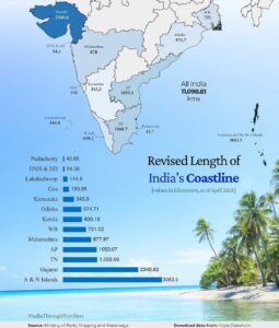
India’s coastline length has increased by nearly 3,582 km (48%) due to more accurate satellite measurements and inclusion of offshore islands, impacting territorial understanding, coastal regulations, and development planning. This significant change in the Indian coastline measurement has far-reaching implications for various aspects of coastal management and maritime activities.
Reasons for Increased Coastline Length:
- Earlier coastline length was 7,516 km based on 1970s data using maps at a scale of 1:4,500,000.
- New measurement uses high-resolution maps at 1:250,000 scale, capturing smaller bends and curves more precisely. This detailed mapping of India’s coastline provides a more accurate representation of the country’s coastal geography.
- Modern GIS technology replaced manual methods, enabling detailed and accurate mapping. The use of electronic navigation charts has significantly improved the precision of coastline measurements.
- The inclusion of many previously omitted offshore islands also contributed to the increase in the coastline of India.
- The phenomenon where coastline length depends on measurement scale is called the coastline paradox. This concept explains why more detailed measurements of India’s coastline result in a longer total length.
Increase in Number of Islands
- Earlier, 1,382 offshore islands were recorded in 2016 by the Office of the Surveyor General of India.
- Different agencies (state governments, Coast Guard, Indian Navy) reported 1,334 islands, causing discrepancies.
- A reconciliation exercise standardized definitions, finalizing the number at 1,389 islands including 91 inshore islands.
- River islands, especially in states like Assam and West Bengal, are excluded from this count.
Implications of Changes
- The increased coastline affects Coastal Regulation Zone (CRZ) coverage and environmental protection policies. This has significant implications for coastal zone management strategies.
- It influences coastal erosion control, climate resilience planning, and disaster management. The revised coastline length impacts the assessment of India’s Exclusive Economic Zone (EEZ).
- The revision has impacts on tourism, infrastructure development, and security measures along the coast. It also affects blue economy planning initiatives.
- The government now mandates a coastline measurement update every 10 years to account for natural and human-induced changes. This regular updating process will involve the Survey of India and the National Hydrographic Organisation.
- The new coastline measurements will play a crucial role in shaping India’s maritime security framework and overall coastal development strategies.
Conclusion
The significant increase in India’s coastline length, as determined by the latest survey using advanced technology and more inclusive mapping techniques, has wide-ranging implications. From environmental protection to economic planning and security considerations, this new data will inform policy-making and development strategies along India’s extensive coastline. Regular updates to these measurements will ensure that India’s coastal management remains responsive to both natural changes and human activities, supporting sustainable development and effective governance of its coastal regions.