EVOLUTION OF LANDFORMS AND THEIR DEVELOPMENT
Introduction
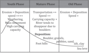
A landform, comprising a small to medium-sized portion of the Earth’s surface, is fundamental to understanding landscapes. Landforms collectively contribute to the diverse terrain we observe, each undergoing a distinct evolutionary process. The evolution of landforms encompasses a series of transformations from one state to another, representing the dynamic nature of the Earth’s surface. These transformations are often categorized into stages—youth, maturity, and old age—each characterized by distinct features and processes.
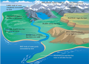
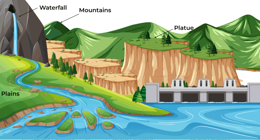
Plateau
A plateau, also referred to as a tableland, constitutes a significant geographical landform characterized by its elevated flat terrain, typically rising abruptly from its surroundings. Covering approximately one-third of the Earth’s land area, plateaus are among the most prominent landforms globally, exhibiting both ancient and relatively recent formations. For instance, the Deccan Plateau in India stands as one of the oldest plateaus, showcasing the enduring nature of these landforms.
Formation and Characteristics
1.Age Variation: Plateaus exhibit varying degrees of age, with some dating back millions of years while others are relatively young. The age of a plateau influences its geological features and the processes shaping it.
2.Valley Formation: The interaction between plateaus and rivers often results in the formation of valleys. Rivers carve through the elevated plateau surfaces, creating intricate valley systems. A prime example is the Columbia River cutting through the Columbia Plateau, showcasing the dynamic interplay between water and landforms.
3.Mineral Resources: Plateaus are often endowed with abundant mineral resources, making them crucial hubs for economic activities such as mining. The Chhota Nagpur Plateau in India stands as a testament to the wealth of mineral deposits found in these regions.
Causes of Plateau Formation
- Thermal Expansion: Upwelling of hot material from the underlying asthenosphere leads to the upliftment of the overlying surface, resulting in the formation of plateaus. Examples include the Ethiopian Plateau in Africa and the Yellowstone Plateau in the United States.
- Crustal Shortening: Plateau formation can also occur through the thrusting of one crustal plate over another or the folding of rock layers. This process often gives rise to mountain ranges along the margins of plateaus, as seen in the Tibetan Plateau.
- Volcanism: Extensive basaltic lava flows contribute to the formation of plateaus through volcanic activity. Notable examples include the Deccan Traps in India, the Canadian Shield, and the Columbia Plateau in the United States.
Types of plateaus:
| Types of Plateaus | Description | Examples |
| Tectonic Plateau | Formed due to the upward movement of the Earth’s crust resulting from the slow collision of tectonic plates. | Tibetan Plateau |
| Volcanic Plateau | Created by the spread of basaltic lava over large distances, often near continental margins or volcanic hotspots. | Deccan Traps (India), Columbia Plateau (USA) |
| Intermontane Plateau | Plateau enclosed by surrounding hills and mountains. | Tibetan Plateau (surrounded by the Himalayas and Kunlun Range), Mongolian Plateau |
| Dissected Plateau | Evolved through the process of denudation, characterized by extensive erosion and dissected terrain. | Colorado Plateau (USA) |
| Continental Plateau | Situated away from mountains, often bordered by plains or seas. | Antarctic Plateau (East Antarctic) |
| Oceanic Plateau | Surrounded by seas or oceans. | Caribbean Plateau |
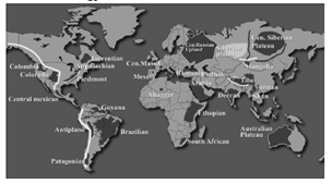
| Piedmont Plateau | Surrounded by mountains on one side and oceans/seas on the other. | Patagonia Plateau (South America) |
| Dome-Shaped Plateau | Middle portion of the landmass raised against its surroundings. | Chota Nagpur Plateau (India) |
Each type of plateau has distinct characteristics and examples to illustrate its formation and geographical features.
Plains
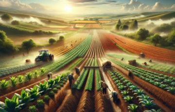
Plains are extensive areas of lowland characterized by gentle slopes and minimal local relief. They are one of the fundamental landforms found on all continents except Antarctica. The significance of plains extends beyond their geological features; they are also crucial for human habitation and activities, often serving as centers of agriculture, urban development, and transportation networks.
Formation of Plains:
Plains originate through various geological processes and can be further developed and modified over time. The primary processes contributing to the formation of plains include:
1. Diastrophic Movements: Plains are often shaped by diastrophic movements, which are large-scale vertical movements in the Earth’s crust. These movements may result in the emergence of submerged coastal lands or the formation of structurally depressed areas.
2. Fluvial Erosion and Deposition: The action of rivers and streams plays a significant role in shaping plains. Fluvial erosion gradually wears down elevated landforms, while the deposition of sediments creates vast alluvial plains, such as the Ganga-Brahmaputra alluvial plain in South Asia.
3. Glaciation: Glacial processes, including the movement and deposition of ice, contribute to the formation of plains known as drift plains or glacial plains. These plains often exhibit distinctive features shaped by the advance and retreat of glaciers.
Types of Plains:
Plains can be classified into several types based on their formation processes and characteristics:
1. Structural Plain: Formed by horizontally bedded rocks, structural plains are structurally depressed areas relatively undisturbed by tectonic activity. They often exhibit a relatively flat topography due to the uniformity of underlying geological structures.
2. Erosional Plain (Peneplain): Elevated landforms are gradually worn down to sea level by the action of erosional agents such as rivers and glaciers. Erosional plains, also known as peneplains, typically feature smooth, gently sloping surfaces.
3. Depositional Plain: These plains are formed through the deposition of eroded materials brought by geomorphic agents. Depositional plains encompass various subtypes, including:
-
- Alluvial Plains: Formed by river deposits, these plains are characterized by fertile soils and are often highly suitable for agriculture. Examples include the vast plains formed by rivers like the Nile, Ganges, and Mississippi.
- Lacustrine Plains: Also known as lake plains, these are formed by the deposition of sediments in lakes. The Kashmir Valley in India is an example of a lacustrine plain, characterized by its scenic beauty and fertile soils.
- Drift Plains: Also referred to as glacial plains, these plains are formed by the deposition of glacial till and other materials left behind by retreating glaciers. The Great Plains of North America are an example of drift plains shaped by the Pleistocene glaciers.
- Loess Plains: Depositional plains formed by the action of winds carrying and depositing fine-grained sediment called loess. These plains often feature fertile soils ideal for agriculture and are found in regions like the North China Plain.
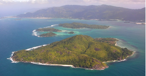
Islands
An island is a geographical feature, typically a piece of land, that is surrounded by water on all sides. Islands come in various forms, each with its unique characteristics and formation processes.
Definition: A piece of land surrounded by water on all sides is termed as an island.
Archipelago: A chain of geologically related islands is known as an archipelago, which can be formed through various geological processes over time.
Types of Islands:
1. Continental Islands:
- These islands are formed on the continental shelf, which is the submerged edge of a continent extending into the ocean.
- Example: Newfoundland, Canada, is a prominent continental island.
2. Volcanic Islands:
- Formed when an underground volcano erupts, ejecting volcanic material that accumulates and solidifies above the sea surface.
- Examples include the Japanese islands, Philippines islands, and many others scattered across the Pacific Ring of Fire.
3. Coral Islands:
- Formed by the accumulation and growth of coral remains over time.
- Coral islands are relatively smaller in size but are greater in number compared to volcanic or continental islands.
- They often boast rich biodiversity due to the diverse marine life around coral reefs.
- Example: The Lakshadweep islands in India are renowned coral islands.
4. Alluvial Islands:
-
- These islands are formed at the mouth of a river where sediment deposition occurs, leading to the emergence of landmasses.
- Alluvial islands are a result of the continual process of sediment transportation and deposition by rivers.
- Example: New Moore Island, formed at the mouth of the Ganga River, is a notable alluvial island.
Formation Processes:
- Continental Shelf Submergence: Continental islands are a result of the submergence of portions of the continental shelf due to various geological activities such as tectonic movements.
- Volcanic Activity: Volcanic islands are formed through volcanic eruptions, where magma rises from the Earth’s mantle and solidifies upon reaching the ocean surface.
- Coral Reef Growth: Coral islands develop over thousands of years as coral polyps secrete calcium carbonate skeletons, gradually building up structures that rise above sea level.
- River Deposition: Alluvial islands form as rivers carry sediment downstream and deposit it at their mouths, gradually building up landmasses over time.
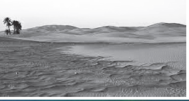
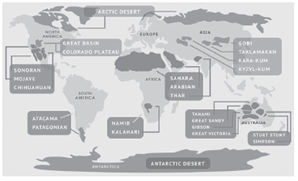
Deserts:
Deserts are defined as areas of land that receive minimal precipitation, typically no more than 25 centimeters in a year. These regions are characterized by their arid and dry conditions, making them inhospitable for most forms of life.
Types of Deserts:
1. Hot Deserts:
- Located on the western margins of continents, typically in tropical regions along cold ocean currents.
- Experience high annual and diurnal temperature ranges due to their position in subtropical high-pressure zones.
- Examples include the Sahara Desert and the Thar Desert.
2. Coastal Deserts:
- Found on the western margins of continents within latitudes ranging between 15° to 30°.
- Less hot compared to hot deserts due to the moderating influence of nearby water bodies, such as cold ocean currents.
- Example: Atacama Desert.
3. Mid-Latitude Deserts:
- Situated in the interior of continents at higher latitudes where moisture-bearing winds cannot reach.
- Aridity primarily attributed to continentality.
- Also referred to as cold deserts.
- Examples include the Gobi Desert and the Taklamakan Desert.
4. Ice and Snow Deserts:
-
- Found in polar regions.
- Examples include Antarctica and Greenland.
Landforms in Deserts:
Deserts exhibit diverse landforms resulting from erosional and depositional processes primarily driven by wind action. Some notable landforms include:
- Sand Dunes: Formed by wind deposition of sand particles, sand dunes come in various shapes and sizes, including crescent-shaped barchan dunes, linear longitudinal dunes, and star-shaped star dunes.
- Ripple Marks: Small-scale ridges and troughs formed on the surface of loose sediment, such as sand, due to the movement of wind or water.
These landforms not only contribute to the unique aesthetics of desert landscapes but also play crucial roles in ecological systems, providing habitats for specialized flora and fauna adapted to harsh desert environments.
Deserts, despite their harsh conditions, hold significant ecological, geological, and cultural importance. Understanding their formation processes and diverse ecosystems is crucial for conservation efforts and sustainable land management practices.
Fluvial Landforms
- Fluvial landforms are a result of the dynamic interplay between erosion and deposition processes driven by running water. These landforms are crucial components of Earth’s surface morphology and play significant roles in shaping landscapes, influencing ecosystems, and affecting human activities. Understanding the formation, processes, and characteristics of fluvial landforms is essential for various fields including geology, geography, and environmental science.
Formation of Fluvial Landforms:
- Fluvial landforms are primarily formed through the degradational action of running water, which involves erosion and subsequent aggregational work of deposition. The process begins with the erosional force of flowing water, which dislodges and transports sediment particles from the land surface, subsequently leading to the creation of various landforms through deposition.
Processes Involved: Fluvial processes encompass three main physical phases, each characterized by distinct actions of running water:
1. Erosion: This initial phase involves the detachment and removal of soil, sediment, and rock particles from the land surface by the force of flowing water. Erosion occurs through different mechanisms such as hydraulic action (pressure exerted by water), abrasion (mechanical wearing away), corrosion (chemical dissolution), and attrition (particle-to-particle collision).
2. Transportation: Once eroded, sediment particles are transported downstream by the moving water. Transportation mechanisms include traction (rolling or dragging of larger particles), saltation (bouncing of smaller particles), suspension (carrying fine particles in the water column), and solution (dissolving soluble materials). The mode of transportation varies depending on factors like water velocity, sediment size, and channel characteristics.
3. Deposition: As the velocity of water decreases or when sediment-carrying capacity diminishes, deposition occurs, leading to the accumulation of sediment particles. Depositional landforms form in locations where sediment settles out of the transporting medium, such as rivers, floodplains, deltas, and alluvial fans. Factors influencing deposition include sediment load, channel slope, water velocity, and vegetation cover.
Characteristics of Fluvial Landforms: Fluvial landforms exhibit diverse characteristics shaped by the interaction between erosional and depositional processes:
1. Morphology: Fluvial landforms display distinctive shapes and features determined by the nature of erosion and deposition. Common morphological features include channels, valleys, meanders, riverbanks, bars, and floodplains.
2. Size and Scale: Fluvial landforms vary in size and scale, ranging from small-scale features like ripples and sandbars to large-scale formations such as river valleys and alluvial plains. The size of landforms is influenced by factors like water discharge, sediment supply, and geological substrate.
3. Dynamic Nature: Fluvial landforms are dynamic and constantly evolving due to ongoing processes of erosion, transportation, and deposition. Changes in hydrological conditions, sediment load, and external factors like climate and tectonics contribute to their dynamic nature.
4. Ecological Importance: Fluvial landforms provide essential habitats for diverse plant and animal species, supporting rich ecosystems. Riparian zones along rivers and streams are particularly biodiverse, serving as breeding grounds, migration routes, and sources of nutrients.
5. Socio-economic Significance: Fluvial landforms have significant socio-economic importance, influencing human activities such as agriculture, transportation, water supply, and recreation. River valleys and floodplains are often densely populated areas due to their fertile soils and access to water resources.
Erosional Landforms
Introduction
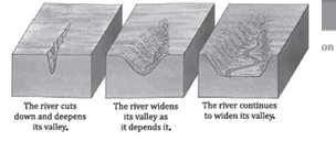
Erosional landforms are prominent features found in the upper course of rivers, particularly during their youth stage, where the erosive forces are most pronounced. These landforms result from the dynamic interaction between flowing water and the underlying geology, shaping the landscape through processes such as deepening and widening of the river channel.
River Valley
The river valley is a primary erosional landform, representing an elongated depression carved by the relentless action of the river over time. Its morphology undergoes significant changes as the river progresses through different developmental stages.
Youth Stage: Gorge and Canyon Formation
- In the early stages, characterized by the youth stage of the river, the erosive energy is primarily focused on vertical downcutting. This results in the formation of a deep V-shaped valley known as a gorge. The steep, narrow profile of the gorge is a testament to the intense vertical erosion.
- As the erosive forces persist, the gorge may transform into a wider feature known as a canyon. Canyons typically exhibit a broader top compared to their bottom, reflecting the ongoing erosional processes that gradually widen the valley.
Mature Stage: U-shaped Valley Development
- With the progression of the river to its mature stage, lateral erosion assumes greater significance. Lateral erosion, coupled with the deposition of sediment, leads to the widening of the valley and the gradual flattening of its floor. This evolution results in the characteristic U-shaped profile of mature river valleys.
- The transformation of the valley occurs through successive stages, starting from the formation of rills, shallow channels created by the erosion of flowing water. Over time, these rills enlarge into gullies and eventually evolve into fully formed valleys.
 Waterfall
Waterfalls are dramatic erosional features that occur where a river encounters alternating layers of soft and hard rock. The erosive action of the river erodes the softer rock more rapidly, leading to the creation of a sudden drop in elevation, known as a waterfall. Over time, waterfalls can retreat upstream as the underlying rock layers continue to erode differentially.
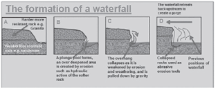
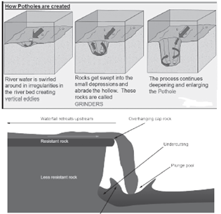
Potholes
Potholes are circular depressions found in the rocky riverbeds, typically formed by the swirling action of water carrying rocks, pebbles, or boulders. This swirling motion results in lateral erosion, creating kettle-shaped depressions resembling the action of grinding tools.
Plunge Pool
Plunge pools are large depressions located at the base of waterfalls. They form through the sustained erosive action of boulders, rocks, and pebbles carried by the flowing water. The impact of these materials on the riverbed excavates a deep depression, contributing to the formation of the plunge pool.
 Rapids
Rapids are characterized by turbulent, swift-flowing sections of the river, resulting from the alternating erosion of soft and hard rock beds. The resistance of hard rocks to erosion creates irregularities in the riverbed, leading to the formation of undulated landforms known as rapids.
River Terrace
River terraces are erosional landforms formed by the vertical erosion of a river into its own depositional floodplain. These terraces mark the surface of the old valley floodplain and can be classified as paired or unpaired terraces based on their elevation relative to the river channel.
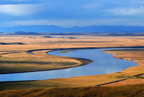
Meanders
Meanders are sinuous or winding sections of a river that develop on gentle slopes due to low kinetic energy. They exhibit distinctive characteristics, including incised meanders in deep, hard rocky areas, and their associated features such as cliffs and slip-off slopes, shaped by the continuous erosional and depositional processes along the river’s course. Meanders often migrate over time, contributing to the dynamic evolution of the river landscape.
Incised Meanders: Exploring Geomorphic Features in Rocky Landscapes
Incised meanders are distinctive formations occurring in deep and resilient rocky terrain, where the river’s erosive forces manifest prominently. These meanders, characterized by both lateral and vertical erosion, can be categorized into two main types: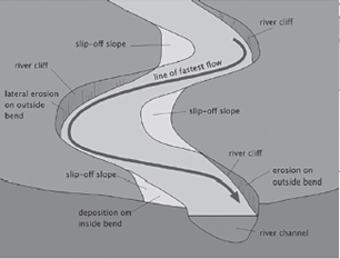
1. Entrenched Meander:
- Symmetrical in shape, entrenched meanders evolve rapidly due to vertical erosion surpassing lateral erosion. This accelerated erosion carves out a pronounced concave slope, known as the cliff-slope side, along the outer bend of the meander loop.
2. Ingrown Meander:
- Asymmetrical in morphology, ingrown meanders develop under conditions where the river’s flow rate is less rapid. This allows for a balanced interplay of lateral and vertical erosion. Consequently, the inner side of the meander loop exhibits a gentle convex slope, termed the slip-off side, formed due to deposition.
These distinctive characteristics provide valuable insights into the dynamic processes shaping river valleys in rugged landscapes, highlighting the complex interactions between erosional and depositional forces.
Depositional Landforms
Depositional landforms are geological features that result from the accumulation or deposition of sediment by natural agents such as rivers. These landforms are formed as a river’s velocity decreases, causing it to deposit the sediment it carries. Two significant examples of depositional landforms are alluvial fans/cones and deltas.
1. Alluvial Fans and Cones: When a river emerges from a mountain valley onto a gentler gradient, its velocity decreases. This reduction in velocity leads to the deposition of sediment carried by the river. Alluvial fans and cones are depositional landforms that form at the base of mountain ranges where rivers transition from steep gradients to flatter terrain. The sediment is deposited in a conical or fan-shaped pattern, creating a characteristic landform. An example of this can be observed in the Bhabar region along the foothills of the Himalayas.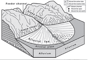
2. Deltas: Deltas are depositional landforms formed at the mouths of rivers where they meet a body of water, typically the sea or a lake. Unlike alluvial fans, where sediment is deposited at the base of a mountain range, deltas form at the terminus of a river’s journey. The formation of deltas is primarily attributed to the reduction in the river’s velocity as it nears sea level, coupled with the influence of saltwater on suspended sediments. As the river’s velocity decreases upon reaching the ocean or a lake, it can no longer carry its sediment load, leading to deposition. The deposited sediments accumulate over time, forming a deltaic landform.
Conditions for the Formation of Deltas:
- Rivers must carry a significant amount of sediment or erosional material to form a delta.
- Deltas typically form in areas where ocean currents are not strong enough to disperse or wash away the deposited sediments. This allows the sediment to accumulate and form the characteristic deltaic shape.
Deltas are complex landforms and can vary in shape and size depending on factors such as the volume of sediment transported by the river, the characteristics of the receiving body of water, and the geological processes at play. The sediments deposited in deltas are often stratified based on size, with coarser materials settling closer to the river mouth and finer materials carried further out into the sea. Understanding the formation and characteristics of deltas is essential for studying coastal geomorphology and land-water interactions.
Types of Deltas:
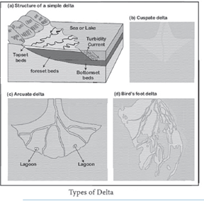 Deltas are diverse landforms that vary in shape and structure based on geological, hydrological, and environmental factors. The classification of deltas helps in understanding their formation processes and the dynamics of sediment deposition. Here are five main types of deltas:
1. Arcuate Delta: Arcuate deltas have a fan-shaped appearance, with a gently curving convex margin facing the sea. They typically form when a river deposits its sediment load at its mouth, spreading out in a fan-like shape. The Ganga-Brahmaputra delta in the Indian subcontinent is a classic example of an arcuate delta.
2. Cuspate Delta: Cuspate deltas have a distinctive arrow-like shape, formed when sediment is deposited onto a straight shoreline with strong waves. The waves push the sediments outward, creating pointed extensions of land into the body of water. The delta formed by the Tiber River in Italy illustrates this type of delta formation.
3. Bird’s Foot Delta: Bird’s foot deltas resemble the spread toes of a bird’s foot, characterized by numerous distributary channels extending outward from the main river channel. They consist mainly of fine particles and are formed when the river’s flow is stronger than the waves, allowing sediment to be deposited and distributed into smaller channels. The Mississippi River delta in the United States is a prominent example of a bird’s foot delta.
4. Lacustrine Delta: Lacustrine deltas form when a river flows into a lake, rather than directly into an ocean or sea. The reduced flow velocity and absence of tidal influences in lakes result in unique deltaic formations. An example is the Lough Leanne River Delta in Ireland, where sediments carried by the river are deposited at the lake’s edge, forming a delta.
5. Abandoned Delta: Abandoned deltas occur when a river shifts its course, leaving behind an already-formed delta that is no longer actively receiving sediment deposition. These deltas may undergo erosion and changes in morphology over time due to factors such as water flow redirection or changes in sediment supply. The Yellow River delta in China provides an example of an abandoned delta, as the river has historically changed its course multiple times, leaving behind abandoned deltaic features.
Understanding the various types of deltas provides insights into the complex interactions between rivers, sediment transport processes, and the dynamics of coastal and lacustrine environments. Each type of delta reflects the unique geological and environmental conditions under which it forms, contributing to the rich diversity of landforms found in deltaic regions worldwide.
Floodplains and Levees:
Floodplain:
- Definition: An expansive area adjacent to a river prone to periodic inundation during floods.
- Characteristics:
- Flat topography.
- Fertile soils due to deposition of sediment carried by floodwaters.
Importance:
- Highly conducive to agriculture.
- Crucial habitats for diverse plant and animal species.
- Regulate water flow and nutrient cycling in river ecosystems.
Levees:
- Definition: Natural embankments or raised mounds along river banks formed by sediment deposition.
- Formation:
- Sediment deposited during floods builds up along river edges.
- Gradually forms raised barriers against floodwaters.
Function:
- Act as natural barriers, confining river flow within its channel.
- Help mitigate extent of flooding on adjacent floodplain.
- Potential Concerns:
- Can increase flood risk downstream by confining river flow.
Point Bars: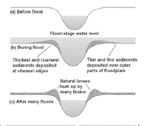
- Definition: Depositional features formed along inner bank of meander bends in rivers.
- Formation:
- Sediment deposition along inner bank as river erodes outer bank.
- Characteristics:
- Gentle slope.
- Support vegetation due to proximity to river channel.
- Role:
- Contribute to lateral migration of meander bends across floodplain.
Oxbow Lakes:
- Definition: Crescent-shaped bodies of water formed from abandoned meander loops.
- Formation:
- Gradual erosion and deposition of sediment along meander bend.
- Eventually, meander loop is cut off from main channel.
- Characteristics:
- Stagnant water.
- Support diverse aquatic ecosystems.
- Ecological Significance:
- Provide habitats for aquatic plants, fish, and waterfowl.
Braided Channels: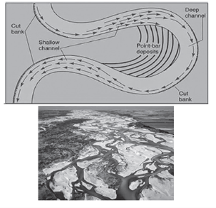
- Definition: Complex river channels with multiple interconnected smaller channels separated by bars of sediment.
- Formation:
- Occur in rivers with high sediment loads and variable flow conditions.
- Sediment deposition creates network of channels and islands.
- Characteristics:
- Dynamic morphology due to shifting sediment deposition and flow patterns.
- Examples:
- Common in glacier-fed rivers.
- Subject to frequent changes in morphology.
Marine landforms
Marine landforms are distinctive geographical features formed by the dynamic actions of oceanic processes, including waves, tides, and currents. These processes sculpt the coastline and the sea floor, creating a variety of landforms that can be observed both along the shoreline and offshore. The formation of these features is a testament to the power of the ocean’s natural forces over geological time scales.
Erosional Landforms
Chasms
- Definition: Chasms are narrow, deep indentations in the coastline, carved by the relentless force of headward erosion caused by waves.
- Formation Process: The process begins with the waves focusing their energy on a specific part of the coastline, gradually wearing away the rock through physical and chemical erosion, eventually creating a deep cut or indentation.
- Examples: Not typically named but can be observed in rugged coastlines.
Sea Cliffs
- Definition: Sea cliffs are steep or vertical faces on the shoreline, formed by the direct erosion of waves.
- Formation Process: They result from the undercutting action of waves at the base of a coastline, which leads to the collapse of the upper sections due to gravity, forming steep cliffs.
- Examples: The White Cliffs of Dover, England.
Wave-cut Platforms
- Definition: A wave-cut platform is a flat, bench-like surface left behind as a cliff retreats due to erosion by waves.
- Formation Process: The waves erode the base of a cliff, causing parts of it to collapse, and over time, this process flattens the area at the base, creating a platform.
- Examples: The Great Ocean Road region in Victoria, Australia.
Sea Caves
- Definition: Sea caves are hollows formed in the base of cliffs by the constant pounding of waves.
- Formation Process: Waves focus their energy on weak points in the cliff face, eroding the rock and forming an opening that eventually widens and deepens into a cave.
- Examples: The sea caves at Flamborough Head, England.
Sea Arches
- Definition: Sea arches are formed when two sea caves from opposite sides of a headland meet, creating an archway.
- Formation Process: Continuous erosion enlarges sea caves until they break through to the other side, forming a natural arch.
- Shape Variations: They can be arcuate (arch-shaped) or rectangular, with the opening sometimes extending below the water level.
- Examples: London Bridge in the Port Campbell National Park, Australia (before its collapse).
Stacks
- Definition: Stacks are isolated, vertical columns of rock left standing after the collapse of a sea arch.
- Formation Process: The roof of a sea arch collapses due to further erosion and the inability to support its own weight, leaving behind a columnar structure.
- Examples: The Old Man of Hoy, Orkney Islands, Scotland.
Blowholes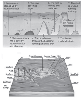
- Definition: Blowholes are formed when sea caves grow vertically upwards, creating a shaft that opens at the surface.
- Formation Process: When waves enter a sea cave with sufficient force, they compress air within the cave. This air pressure can force water upwards, erupting through the shaft and creating a spectacular spout on the surface.
- Examples: The Hummanaya Blowhole, Sri Lanka.
These landforms illustrate the ongoing battle between the land and the sea, where the relentless force of the ocean shapes the earth’s surface in spectacular ways. Each landform not only adds to the natural beauty of coastal regions but also serves as a living record of geological processes at work.
Depositional Landforms
Depositional landforms are created by the accumulation of sediments carried by waves, currents, and other geological processes. These landforms are essential to the coastal environment, providing habitats for various species and protecting inland areas from storms and erosion.
Beach
- Definition: A beach is a gently sloping shoreline feature composed of sand, pebbles, gravels, or other debris deposited by the actions of waves and currents.
- Formation Process: Waves and currents transport sediments towards the shore, where they are deposited as the water loses energy.
- Significance: Beaches act as barriers against erosion, absorbing energy from waves and storms.
Bars & Barriers
- Definition: Bars are submerged ridges of sand or sediment formed by the action of waves and currents parallel to the shoreline. When these structures emerge above the water level, they are known as barrier bars or simply barriers.
- Formation Process: Currents slow down as they approach the shore, causing sediments to accumulate and form bars. Over time, these can grow to become barriers.
- Significance: They protect the shoreline from erosion and can form lagoons between the barrier and the mainland.
Lagoon
- Definition: A lagoon is a shallow body of water separated from the sea by a barrier, such as a sandbar or a barrier island.
- Formation Process: Lagoons are formed when barriers like sandbars prevent the water behind them from returning to the sea, creating a separated water body.
- Significance: Lagoons are rich in biodiversity, serving as nurseries for many marine species.
Spits and Hooks
- Definition: A spit is an elongated ridge of sand or sediment that extends from the mainland into the sea, attached at one end to the shore. When the end of a spit is curved landwards, it forms a hook.
- Formation Process: Spits are formed by the longshore drift of sediment along the coast. The curve of a hook is often due to changes in wind direction or where the current meets a river outflow.
- Significance: Spits and hooks can protect the coastline from waves and form natural harbors.
Tombolo
- Definition: A tombolo is a deposition landform that connects an island to the mainland or to another island by a narrow piece of land, such as a spit or bar.
- Formation Process: Tombolos are formed when the sediment deposited by wave action builds up between an island and the coastline.
- Significance: They can create unique ecosystems and provide access to islands.
Glacial Landforms
Glacial landforms result from the movement and melting of glaciers, which are large masses of ice that flow like very slow rivers. Glaciers shape the landscape through processes of erosion and deposition:
Abrasion
- Definition: Abrasion occurs when rocks and stones frozen into the base or sides of a glacier grind against the bedrock as the glacier moves.
- Effect: This process smoothens and polishes the surface beneath the glacier, creating striations (scratches) and grooves in the bedrock.
- Significance: Abrasion can significantly alter the landscape, creating smooth, polished surfaces and contributing to the formation of glacial valleys.
Plucking
- Definition: Plucking is the process by which a glacier picks up rocks as it moves over the bedrock. Water at the base of the glacier freezes into cracks in the rock, and as the glacier moves, it pulls chunks of rock away.
- Effect: Plucking leaves behind a jagged and rugged landscape, with large boulders and rocks being transported away from their original locations.
- Significance: Plucking contributes to the deepening and widening of valleys and the shaping of mountainous terrains.
These glacial and depositional processes play crucial roles in shaping the Earth’s surface, creating diverse and dynamic landscapes that vary greatly from one region to another. Each landform holds vital ecological significance and contributes to the global environmental system in unique ways.
Erosional Landforms Created by Glaciers
Glaciers, immense rivers of ice, possess the power to sculpt vast portions of the Earth’s landscape. Through their slow but relentless movement, glaciers erode the underlying rock, creating distinct landforms that reveal the history and scale of glacial activity.
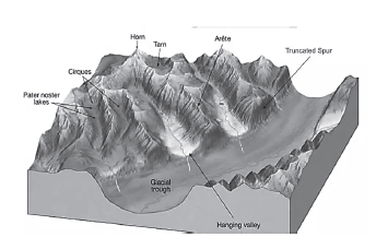
Cirque (Corrie)
- Definition: A cirque, also known as a corrie, is a bowl-shaped, steep-walled basin carved into the mountainside by the rotational movement of glacier ice.
- Formation Process: Cirques form as glaciers erode the land through plucking and abrasion, deepening natural depressions on the mountainside into hollowed-out basins.
- Resulting Feature: When the glacier melts, these basins may fill with water, forming tarn lakes.
- Significance: Cirques are often the starting points of glacier formation and provide clear evidence of past glacial activity.
Horn
- Definition: A horn is a sharp, pyramid-shaped peak that forms when several cirque glaciers erode a mountain from multiple sides.
- Formation Process: The headward erosion of cirques around a mountain summit meets, sharpening the peak into a horn.
- Examples: A famous example is Mount Everest, although it is formed by tectonic rather than purely glacial processes. The Matterhorn in the Swiss Alps is a classic example of a horn shaped by glacial erosion.
- Significance: Horns are dramatic landscape features that indicate the extent of glacial carving in mountainous regions.
Arête
- Definition: An arête is a narrow, knife-edge ridge formed between two parallel glacial valleys or cirques.
- Formation Process: As glaciers erode the valleys or cirques on either side of a ridge, the remaining rock is sharpened into a steep-sided, jagged edge.
- Significance: Arêtes are emblematic of high alpine glacial action, illustrating the powerful erosive forces at play.
Glacial Trough (U-Shaped Valley)
- Definition: A glacial trough, or U-shaped valley, is characterized by its wide, flat floor and steep sides.
- Formation Process: This landform is created by the erosive action of a glacier as it moves down a valley, widening and deepening the existing river valley into a U-shape.
- Significance: U-shaped valleys are distinctive features of glaciated mountainous regions, contrasting with the V-shaped valleys formed by river erosion.
Hanging Valley
- Definition: A hanging valley is a smaller valley that terminates high above the floor of a main valley, often forming waterfalls.
- Formation Process: They are created when tributary glaciers, which are less powerful than the main glacier, carve valleys that are not as deeply eroded.
- Significance: Hanging valleys provide picturesque landscapes and are often sites for spectacular waterfalls.
Fjord
- Definition: A fjord is a deep, narrow sea inlet bordered by steep cliffs or slopes, created by the submergence of a glacial trough.
- Formation Process: Fjords are formed when glacial troughs extend below sea level and are subsequently filled with seawater as the glacier retreats.
- Locations: Fjords are iconic features of Norway, Greenland, New Zealand, and other regions with past or present glacial activity.
- Significance: Fjords are among the most dramatic and beautiful coastal features, combining the power of glacial erosion with sea level changes.
These glacial erosional landforms highlight the dynamic processes of glacier movement and melting, which have shaped and continue to shape landscapes around the world. The presence of these features not only provides evidence of past glacial activity but also contributes to the biodiversity and geological diversity of the regions in which they are found.
Depositional Landforms Created by Glaciers
Glaciers are not only powerful agents of erosion but also play a significant role in depositing materials across landscapes. As glaciers advance and retreat, they transport and deposit an array of sediments, ranging from fine silt to large boulders. These deposits form various glacial depositional landforms, each with unique characteristics and formation processes.:
Glacial Till
- Definition: Glacial till refers to the unsorted mixture of coarse and fine debris that a glacier drops as it melts.
- Characteristics: The composition of till is highly variable, including everything from clay and silt to sand, gravel, and boulders, reflecting the diverse materials a glacier can pick up as it moves.
Moraines
- Definition: Moraines are accumulations of glacial till that form long ridges, and they are classified based on their location relative to the glacier:
- Terminal Moraines: Found at the furthest point of glacial advance, marking the maximum extent of the glacier.
- Lateral Moraines: Formed along the sides of a glacier, parallel to its flow.
- Ground Moraines: Deposited as a layer or blanket of till left behind over the valley floor when a glacier retreats.
- Medial Moraines: Formed when two glaciers with lateral moraines join, creating a ridge of till running down the center of the resulting glacier.
Outwash Plain
- Definition: An outwash plain, or sandur, is a broad, flat area of stratified (layered) deposits made of sand, gravel, and other sediments, left by meltwater flowing away from the glacier.
- Formation Process: As glaciers melt, the meltwater carries sediments away from the glacier and deposits them in layers, creating an outwash plain.
- Features: Hummocks, or low mounds, can form on outwash plains, adding to the varied topography.
Esker
- Definition: Eskers are long, winding ridges of sand and gravel that formed within the ice-walled tunnels of a glacier, through which meltwater flowed.
- Formation Process: After the glacier melts, the deposits within these tunnels are left as long, snaking ridges that trace the path of the subglacial river.
- Significance: Eskers can serve as natural aqueducts and are indicators of the subglacial water flow direction.
Drumlins
- Definition: Drumlins are streamlined, elongated hills of glacial till that are shaped like inverted spoons, with one end steeper than the other.
- Stoss End: The blunt, steeper end facing the direction from which the glacier came.
- Tail: The tapered, gentler end pointing in the direction the glacier was moving.
- Formation Process: Formed beneath glaciers, drumlins are shaped as the ice moves over the till, compressing and molding it into these smooth, streamlined forms.
- Significance: Drumlins indicate the direction of glacial movement and are part of what is sometimes called a “basket of eggs” topography due to their shape and distribution.
Kames
- Definition: Kames are irregularly shaped hills or mounds composed of sand, gravel, and till deposited by meltwater from a retreating glacier.
- Formation Process: They form when sediment is deposited by meltwater into depressions or on the flat surfaces of retreating glaciers, and are left behind as the ice melts.
- Significance: Kames add to the complex topography of glacial landscapes and can indicate the presence of meltwater channels or ponds on the glacier surface.
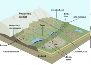 These depositional landforms provide valuable insights into past glacial movements and the dynamic processes associated with glaciation and deglaciation. Their study helps geologists understand the extent of ice cover, climatic conditions, and the evolution of landscapes influenced by glaciers.
Arid landforms
Arid landforms are shaped by the unique climatic conditions of arid regions, which are characterized by low rainfall and strong wind action. These conditions lead to the formation of distinctive erosional features, which can be categorized based on the primary erosive agent: water or wind.
Erosional Landforms in Arid Regions
Water Eroded Landforms
- Rill: A rill is a small, shallow channel cut into soil by the flowing water. Rills are among the first signs of water erosion on a landscape, forming as water runoff begins to concentrate in narrow pathways, eroding the soil as it flows.
- Gully: When rills become more extensive, they widen and deepen, evolving into gullies. Gullies are larger channels that can be several meters deep and wide, indicating more severe water erosion.
- Ravine: A ravine represents an advanced stage of gully erosion. It is characterized by steep sides and is significantly deeper than a gully, often forming in areas where water flow is highly concentrated over time, further deepening and widening the gully.
- Badlands Topography: This type of topography is characterized by a maze of gullies and ravines, creating a rugged and almost barren landscape. Badlands form in regions where soft sedimentary rocks and clay-rich soils have been extensively eroded by water, creating a series of steep slopes, sharp peaks, and valleys.
- Bolsons: A bolson is a type of intermountain basin found in arid and semi-arid regions. It is a closed depression surrounded by mountains, with no outlet for water, leading to temporary lake formations within the basin.
- Playas: Also known as alkali flats or salt flats, playas are flat-bottomed depressions that can be found in interior desert basins. They form when water from rain or snowmelt accumulates in bolsons, evaporates, and leaves behind layers of salt, silt, and clay.
Wind Eroded Landforms
1. Deflation Basins: Also known as blowouts, these are depressions or hollows formed by the wind’s removal of loose, fine-grained particles from the ground. They are common in desert areas where vegetation is sparse, and the soil is dry and unprotected.
2. Mushroom Rocks: These are unique rock formations shaped by wind erosion, featuring a slender stalk and a broad, cap-like top. The differential erosion occurs because the lower part of the rock is more exposed to abrasive sand particles carried by the wind, while the upper part is somewhat protected.
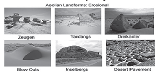
3. Inselberg: An inselberg, or monadnock, is an isolated hill or small mountain that rises abruptly from a gently sloping or virtually level surrounding plain. Inselbergs are residual features, typically formed by the differential erosion of the surrounding softer materials.
4. Demoiselles: These are tall, slender rock pillars formed through differential erosion, where harder rock layers overlie softer ones. The softer rock erodes away more quickly, leaving the harder rock standing in relief.
5. Yardangs: These are streamlined, wind-eroded ridges that are oriented in the direction of the prevailing winds. Yardangs are sculpted in bedrock or in tightly compacted sediments by the abrasive action of windblown sand.
6. Zeugen: Zeugen are formed in regions with significant temperature fluctuations, which lead to the expansion and contraction of rock. This process, combined with the presence of moisture, causes the rock to disintegrate along its joints. Zeugen typically have a softer rock base with a harder caprock that resists erosion better.
These landforms are a testament to the power of erosional processes in shaping the earth’s surface, particularly in environments where water is scarce and wind plays a dominant role in landscape evolution.
Depositional landforms in arid environments are primarily shaped by the deposition of sediments by wind and, to a lesser extent, water. These landforms are critical in understanding the dynamics of desert landscapes and the processes of sediment transport and deposition.
Depositional Landforms
Ripple Marks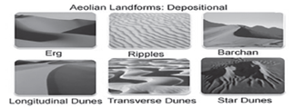
- Description: Ripple marks are small waves of sand or sediment formed on the surface of sand or mud. They are indicative of the movement of water or wind over the sediment surface, creating alternating ridges and troughs.
- Formation: These features form at the interface between fluid (water or air) and sediment, where the flow of the fluid generates regular patterns of sediment deposition and erosion.
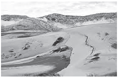
Sand Dunes
Sand dunes are mounds or ridges of sand accumulated by the wind. They vary in shape and size, depending on wind direction and speed, sediment supply, and vegetation cover. They are categorized into several types:
1. Barchan Dunes
- Shape: Crescent-shaped with the tips or “horns” pointing downwind.
- Features: They have a gentle slope on the windward side and a steep slope on the leeward side.
- Occurrence: Common in areas with limited sand supply and a unidirectional wind pattern.
2. Transverse Dunes
- Shape: Large, linear ridges of sand that lie perpendicular to the wind direction.
- Features: These dunes form continuous lines and are typical in areas with abundant sand.
3. Longitudinal Dunes
- Shape: Long ridges of sand that align parallel to the prevailing wind direction.
- Features: They form in regions where wind directions are consistent over time.
4. Parabolic Dunes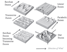
- Shape: U-shaped with the open end facing upwind, opposite of barchan dunes.
- Features: The arms of the dune extend upwind, anchored by vegetation.
- Occurrence: Often found along coastlines or in semi-arid areas where vegetation can stabilize the dune’s arms.
5. Seif Dunes
- Shape: Long, narrow ridges of sand with a sinuous form, having a sharp crest and typically one dominant slip face.
- Features: They can develop from barchan dunes when the wind direction shifts regularly.
6. Star Dunes
- Shape: Large, pyramidal sand mountains with slopes facing in various directions.
- Features: Form in areas with multi-directional wind regimes, allowing the dune to grow upwards rather than laterally.
7. Reversing Dunes
- Shape: Dunes that exhibit features of two or more dune types, changing shape as the wind direction changes.
- Features: They form in environments where wind directions vary seasonally.
8. Whaleback Dunes
- Shape: Large, elongated dunes that resemble the back of a whale.
- Features: Formed from the coalescence of longitudinal dunes or as longitudinal dunes grow in size and merge.
- Occurrence: Also known as “draas” when they are exceptionally large, these are typically found in regions with a significant supply of sand.
Loess
- Description: Loess is a fine-grained, silt-sized sediment that is formed by the accumulation of wind-blown dust.
- Formation: It is deposited over vast areas and can form thick, fertile soils. Loess deposits are typically uniform, loosely cemented, and highly porous, making them highly susceptible to erosion if the surface is disturbed.
- Occurrence: Found in many parts of the world, loess deposits are significant in China, the Midwestern United States, and Central Europe, where they form some of the most productive agricultural lands.
These depositional features are essential components of arid landscapes. They not only shape the physical environment but also influence local climates, vegetation patterns, and human activities. Understanding these landforms is crucial for managing and conserving desert habitats and for mitigating the impacts of desertification and climate change.
Karst landforms
Karst landforms represent a unique and fascinating type of landscape sculpted largely through the chemical dissolution of soluble rocks by groundwater and, to a lesser extent, surface water. These landforms are predominantly found in areas where limestone is a significant component of the bedrock, though they can also occur in regions with other soluble rocks such as dolomite and gypsum. The formation and evolution of karst landscapes are a testament to the power of natural processes over geological timescales, resulting in a variety of distinctive and often spectacular topographical features.
Conditions for Development
The development of karst landforms is contingent upon several key conditions
- Presence of Soluble Rocks: The most critical factor is the existence of highly soluble rocks, primarily limestone, dolomite, and gypsum, either at the surface or just beneath it. These rocks dissolve in the presence of slightly acidic water, which is often the result of rainwater mixing with carbon dioxide in the atmosphere or soil, forming a weak carbonic acid solution.
- Rock Structure: The rocks should be dense, highly jointed, and thinly bedded. These physical characteristics facilitate the penetration of water, enhancing the dissolution process.
- Availability of Water: The presence of groundwater or surface water streams is essential. Water acts as the primary agent of erosion and deposition, driving the chemical processes that shape karst landscapes.
Erosional Landforms
Karst landscapes are marked by several erosional features, including:
- Caverns: These are large underground cave systems formed by the dissolution of limestone by carbonation, a process where carbonic acid in water dissolves the limestone.
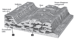
- Sinkholes (or Dolines): Sinkholes are depressions or holes in the ground formed when an area of limestone bedrock is dissolved and collapses. They vary in size and can be quite large and deep.
- Uvala: An uvala is a larger depression formed by the coalescence of several sinkholes. The merging of these features creates a compound sinkhole with a more complex shape.
- Karst Window: This feature occurs when the roof of a subterranean river collapses, exposing the river to the surface. It often appears as a broad open area amidst the karst landscape.
- Polje (or Blind Valley): A polje is a large flat-bottomed valley formed by the coalescence of several uvalas. These valleys are distinctive in that surface streams may disappear into them, losing themselves to the underground.
- Hums: These are residual hills or curved limestone relics that remain after extensive erosion of the surrounding area.
Depositional Landforms
The deposition of minerals from water also leads to the formation of unique features in karst landscapes:
- Stalactite & Stalagmite: These features form from the precipitation of calcium carbonate from dripping water in caves. Stalactites hang from the ceiling, while stalagmites rise from the floor. They grow slowly over centuries and can eventually join to form a column.
- Column: A column or pillar is created when a stalactite growing downward from the ceiling meets a stalagmite growing upward from the floor.
These karst features contribute to a landscape that is both geologically significant and visually stunning. Karst regions offer critical insights into the processes of chemical weathering and erosion, groundwater flow dynamics, and the interaction between biological and geological systems. They also pose unique challenges for human habitation and land use, including water supply issues and the risk of sudden sinkhole formation.
UPSC PREVIOUS YEAR QUESTIONS
1. Which one of the following pairs is correctly matched? (2013) Geographical Region Feature
(a) Abyssinian Plateau – Arabia
(b) Atlas Mountains North-Western Africa
(c) Guiana Highlands South-Western Africa
(d) Okavango Basin – Patagonia
2. Which one of the following is the characteristic climate of the Tropical Savannah Region? (2012)
(a) Rainfall throughout the year
(b) Rainfall in winter only
(c) An extremely short dry season
(d) A definite dry and wet season
3. Normally, the temperature decreases with the increase in height from the Earth’s surface, because (2012)
1. The atmosphere can be heated upwards only from the Earth’s surface
2. There is more moisture in the upper atmosphere.
3. The air is less dense in the upper atmosphere.
Select the correct answer using the codes given below:
(a) 1 only (b) 2 and 3 only
(c) 1 and 3 only (d) 1, 2 and 3