URBANIZATION
Introduction
- Urbanization represents a fundamental transformation in the way human societies are organized and how they interact with the natural environment. This process is characterized by a significant shift in population distribution, moving from predominantly rural settings to urban centers.
The Essence of Urbanization
- At its core, urbanization is about the progressive increase in the proportion of people living in urban areas compared to rural ones. This demographic shift is accompanied by a change in lifestyle, economic activities, and the physical landscape. Urban areas, traditionally known for their dense population and built environment, become the focal points of economic, social, and cultural activities.
Transformation of Land Use
- One of the most visible impacts of urbanization is the transformation of land use. Land previously dedicated to agriculture and natural ecosystems is converted to accommodate residential, commercial, industrial, and transportation needs. This change is not confined to the urban core but also extends to peri-urban and suburban areas, which serve as transitional zones between rural and urban landscapes. These areas often witness rapid development, blurring the boundaries between urban and rural settings.
Urban Areas and Their Expanding Boundaries
- Urbanization is not limited to the growth of cities in terms of population. It also involves the expansion of urban areas into the surrounding countryside. This expansion creates a mosaic of heavily populated urban centers, peri-urban areas with mixed land use, and suburbs primarily characterized by residential development. The process reflects a complex interaction between demographic growth, economic development, and spatial planning, leading to diverse urban forms and patterns.
Measuring Urbanization: The Urbanization Rate
- The urbanization rate serves as a crucial metric for understanding this phenomenon. It is defined as the average annual rate of change of the urban population’s percentage. This rate reflects how quickly or slowly a country or region is urbanizing, providing insights into the pace of urban growth and its management challenges.
Global Response: Sustainable Urban Development
- Recognizing the profound impact of urbanization on societies and the environment, the United Nations Department of Economic and Social Affairs has identified Sustainable Development Goal 11 (SDG 11). This goal is dedicated to making cities and human settlements inclusive, safe, resilient, and sustainable. SDG 11 underscores the importance of addressing the challenges of urbanization through sustainable urban planning and management practices. It calls for efforts to ensure that cities provide opportunities for all, with access to basic services, energy, housing, transportation, and more, while also minimizing their environmental impact.
Urbanization
Urbanization is a complex and multifaceted phenomenon that has become one of the defining features of contemporary society. It encompasses demographic shifts, economic transformations, and social changes. This analysis provides a detailed look into the definition of urban areas, the process of urbanization, and its implications for society.
Defining Urban Areas
- Urban areas are identifiable through specific characteristics that distinguish them from rural settings. These characteristics are not only related to the physical and administrative setup of a region but also to its demographic and economic aspects.
Administrative Criteria
- Municipal Governance: Urban areas are often governed by a municipality, corporation, cantonment board, or notified town area committee. These administrative bodies are responsible for providing essential services and infrastructure.
Demographic and Economic Criteria
- Population Size: An area is considered urban if it has a population of at least 5,000 persons.
- Population Density: A density of at least 400 people per square kilometre is another criterion for urban classification, indicating a compact settlement pattern.
- Employment: An area where at least 75% of the male main working population is engaged in non-agricultural activities is classified as urban. This reflects the economic transition from agrarian-based activities to industrial, commercial, or service-oriented jobs.
The Process of Urbanization
- Urbanization is closely tied to the broader processes of economic and industrial development.
Industrialization and Urbanization
- The relationship between industrialization and urbanization is symbiotic. Industrialization acts as a magnet, drawing people from rural areas to cities in search of employment and better living conditions. This migration is spurred by the promise of industrial jobs, which are typically more lucrative and stable than agricultural work.
Concentration of Resources and Activities
- Urban areas become hubs for industrial, commercial, financial, and administrative facilities. Advances in transportation and communication technologies further facilitate this concentration, making cities attractive places for both work and leisure. Cultural and recreational activities also flourish in urban settings, adding to their appeal.
Economic Growth and Urban Expansion
- Urbanization is both a component and driver of economic growth. As the economy expands, there is an increase in per capita income, fueling demand for non-agricultural goods and services. This economic dynamism encourages further urban growth and development.
Urbanization in India: A Multidimensional Phenomenon
- In India, urbanization is recognized as a socio-cultural, economic, and geographical phenomenon. It reflects not only the physical expansion of urban areas but also significant changes in the societal structure, cultural practices, and economic activities of the population.
The 74th Constitutional Amendment Act, 1992
The 74th Constitutional Amendment Act, implemented in 1992, represents a landmark in the evolution of urban governance in India. It introduced Part IXA to the Constitution, focusing on the organization, empowerment, and functioning of municipalities across the country. This amendment aimed to provide a constitutional foundation to promote decentralized and democratic governance in urban areas, ensuring greater participation of the citizens in the administrative processes.
Key Features of the 74th Amendment
- Constitution and Composition of Municipalities: The Amendment categorizes urban local bodies into three types, based on their size and the nature of urbanization:
- Nagar Panchayat: For areas transitioning from rural to urban.
- Municipal Council: For smaller urban areas.
- Municipal Corporation: For larger urban areas.
- Constitution of Wards Committees: It mandates the formation of Wards Committees in municipalities with a population exceeding 3 lakhs. These committees are instrumental in ensuring a closer and more direct form of governance, allowing for localized decision-making and administration.
- Reservation of Seats: The Amendment provides for the reservation of seats for Scheduled Castes (SCs) and Scheduled Tribes (STs), ensuring their adequate representation in municipal bodies. It also mandates a reservation of not less than one-third of the total seats for women, promoting gender equality in urban governance.
- Finance Commission: The Finance Commission, as established under Article 243-I of the Constitution, has been tasked with reviewing the financial position not only of the Panchayati Raj Institutions but also of the municipalities. It makes recommendations regarding the distribution of financial resources to them, ensuring a fair allocation of funds.
- Committee for District Planning: The Amendment emphasizes the importance of integrated development planning at the district level. It envisages the District Planning Committee as playing a pivotal role in consolidating plans prepared by Panchayats and Municipalities, aiming for harmonized development across the district.
- Elections, Duration, Finances, and Powers of Municipalities: It lays down the structure for periodic elections to the municipalities, ensuring their democratic functioning. The municipalities are to have a fixed term of five years. In case of dissolution, elections must be conducted within six months. The Amendment outlines the financial powers of the municipalities, granting them the authority to levy taxes, fees, and charges as per the provisions of state legislation. It also delineates the functional domain of municipalities, including urban planning, regulation of land use, road and bridge maintenance, water supply, public health, sanitation, and solid waste management.
- Impact and Significance The 74th Amendment has fundamentally changed the landscape of urban governance in India by providing a constitutional mandate for the decentralization of power to urban local bodies. This has not only enhanced the accountability and responsiveness of municipal administrations but also opened up avenues for more inclusive and participatory governance. The Amendment acknowledges the critical role of urban local bodies in addressing the unique challenges of urbanization and seeks to empower them to become effective instruments of socio-economic development and environmental sustainability.
- Despite its significant potential, the implementation of the 74th Amendment has faced challenges, including variations in the devolution of powers across states, financial constraints, and capacity issues of urban local bodies. Addressing these challenges is essential for realizing the full potential of the Amendment in transforming urban governance and making cities more livable, inclusive, and sustainable.
- Types of Urban Settlements: Diversity and Complexity Urban settlements are dynamic entities that reflect the complexity of human civilization. These settlements vary widely in size, function, and the range of services they offer. Understanding the different types of urban settlements is crucial for grasping the nuances of urban development and planning.
- Town: A town is a type of urban settlement that offers a glimpse into the transition from rural to urban living. Unlike villages, towns typically have a more developed infrastructure and offer a wider range of functions, including manufacturing, retail and wholesale trade, and professional services. The distinction between towns and villages is not solely based on population size but also on the presence of specific urban functions. Examples of towns include Adoor in Kerala and Bhimtaal in Uttarakhand.
- City: Cities represent a significant step up from towns in terms of size, economic activities, and importance. A city is essentially a leading town that has surpassed its local or regional counterparts. Cities are characterized by substantial economic activities, the presence of major financial institutions, regional administrative offices, and transportation hubs. They are the physical embodiment of complex associative life, as noted by Lewis Mumford. Cities like Mumbai, Kolkata, and Bangalore are prime examples. A city reaches the status of a “million city” once its population exceeds one million.
- Conurbation: The term “conurbation” was introduced by Patrick Geddes in 1915 to describe a large urban area formed by the merging of several towns or cities. Conurbations are typically characterized by continuous urban expansion and the blending of previously independent settlements. Examples include Greater London, Manchester, Chicago, and Tokyo, with Mumbai and Delhi NCR being notable examples in India.
- Megalopolis: A megalopolis, a term popularized by Jean Gottman in 1957, refers to a “super-metropolitan” region that is a union of conurbations. This type of urban settlement is vast, stretching over large geographical areas and often encompassing multiple cities and towns. The urban area stretching from Boston to Washington in the United States is a well-known example of a megalopolis. In India, Kolkata is considered a megalopolis due to its extensive urban sprawl.
- Million City: The phenomenon of “million cities” has seen rapid growth, with more cities reaching a population of one million than ever before. London was the first city to achieve this milestone in 1800, followed by Paris, New York, and others. By 1950, there were over 80 million cities worldwide. In India, cities like Mumbai and Delhi are prominent examples of million cities.
- Rurban Areas: “Rurban” areas represent a blend of rural and urban characteristics, forming clusters of villages that show potential for growth and have economic drivers. These areas benefit from favorable geographic and competitive conditions and are identified based on population thresholds that vary by geographic region. Villages around Pune serve as examples of rurban areas, highlighting the potential for development in these hybrid spaces.
- Urban Village: The concept of an urban village captures the essence of rural-urban conflicts and transitions. While administratively merged with urban wards upon notification, urban villages retain distinctly different characteristics from the rest of the ward. These areas underscore the challenges and complexities of urban expansion and integration. Mundka village in north Delhi is an example of an urban village.
Classification of Urban Areas in India
The classification of urban areas in India, as per the Census of India 2011, is based on certain features which lead to the categorization of an area as either a Statutory Town (ST) or a Census Town (CT).
| Category | Definition | Criteria | Local Governance | Examples | Number (2011 Census) |
| Statutory Town (ST) | Places recognized under law by the State/UT Government. | Have a municipality, corporation, cantonment board, or notified town area committee. | Governed by local bodies like municipal corporations, municipalities, municipal committees, etc. | Vadodara (Municipal Corporation), Shimla (Municipal Corporation) | 4,041 towns |
| Census Town (CT) | Places that possess urban features but do not have a statutory town status. | Minimum population of 5,000.
At least 75% of male labor force engaged in non-agricultural activities. Population density of at least 400 persons per sq. km. |
Do not have a statutory local government structure specific to urban areas but are recognized as urban based on demographic and economic criteria. | Not specified | Not directly mentioned, but implied to be part of the urban classification. |
Key Differences Between Statutory and Census Towns:
- Legal Status and Governance: Statutory Towns are officially recognized and governed by urban local bodies established by law, whereas Census Towns are identified based on census criteria without specific urban governance structures.
- Criteria for Classification: The classification into Statutory or Census Towns depends on legal status, population size, the proportion of the workforce engaged in non-agricultural activities, and population density.
- Evolution of Urban Areas: The increase in the number of Statutory Towns from 3,799 in 2001 to 4,041 in 2011 reflects the evolving urban landscape in India, with more areas acquiring urban characteristics and governance structures.
Urban Agglomeration and Urban Governance Structures
- Urban Agglomeration (UA) and various urban governance structures like Out Growths (OG), Notified Area Committees, Cantonment Boards, and Satellite Towns are crucial elements in understanding the organization and management of urban spaces. These concepts play a significant role in the planning and development of urban areas, addressing the needs of growing populations and ensuring the provision of essential services and infrastructure.
Urban Agglomeration (UA)
- Urban Agglomeration refers to a continuous urban spread consisting of a town and its nearby Out Growths (OGs), or two or more geographically adjacent towns, with or without their outgrowths. This concept captures the essence of urban expansion beyond traditional city limits, reflecting the complex nature of urban growth.
- Statutory Town Inclusion: A statutory town must be part of an Urban Agglomeration.
- Population Threshold: According to the 2001 Census, the total population of the agglomeration’s components cannot be less than 20,000.
- Classification: The Census of India 2011 further classifies Urban Agglomerations as Class – I to Class – VI, based on their population size.
- Prevalence: As of the 2011 Census, there were 475 UAs/Towns identified across India.
Out Growths (OG)
- Out Growths are viable units such as villages or parts of villages contiguous to a statutory town, possessing urban features in terms of infrastructure and amenities. These include pucca roads, electricity, taps, drainage systems, educational institutions, post offices, medical facilities, and banks. Examples include railway colonies, university colonies, and port areas that may develop near a city or statutory towns outside their statutory limits but within the revenue limit of contiguous villages.
Notified Area Committee
- A Notified Area Committee is an urban organization responsible for administering a notified area, particularly in rapidly developing industrial towns or undeveloped towns not yet meeting municipality formation requirements. It is established through a gazette notification.
Cantonment Board
- A Cantonment Board oversees municipal operations for civilians within the cantonment area, established and run by the central government under the Ministry of Defense’s administrative control. The Cantonments Act of 2006 aims for greater democratization, strengthened financial base, and inclusion of provisions for developmental activities. There are 62 cantonment boards across the nation as of now.
Satellite Town
- A Satellite Town, or Satellite City, is a smaller metropolitan area located close to but mostly independent of larger metropolitan areas. These towns may be self-sufficient, located outside their larger metropolitan areas. Examples around Delhi include Noida, Gurgaon, and Ghaziabad, serving as pivotal areas for relieving urban congestion and spreading urban development more evenly.
Classification of Cities into Tiers in India
The classification of cities into tiers is a common approach used to understand the urban landscape of India, reflecting varying levels of urbanization, economic development, infrastructure, and real estate markets. This classification, as recognized by the Reserve Bank of India (RBI), categorizes cities based on population size and other developmental parameters.
Tier-I Cities
- Population: 1 lakh (100,000) or more as per the 2001 census.
- Characteristics: These cities are the economic and cultural hubs of India, featuring well-established businesses, thriving real estate markets, and comprehensive civic and social amenities. They have the highest property prices in the country.
- Examples: Delhi, Mumbai, Chennai.
- Economic Impact: Tier-I cities are pivotal in driving the nation’s economy, attracting both domestic and international investments.
Tier-II Cities
- Population: 50,000 to 99,999.
- Characteristics: Characterized by rapidly expanding infrastructure and real estate markets, these cities are in the process of development but have not yet reached the saturation levels of Tier-I cities. They offer more affordable living and investment opportunities.
- Examples: Bhopal, Nagpur, Patna.
- Economic Impact: With steady growth, Tier-II cities are emerging as significant players in the national economy, balancing between urbanization pressures and opportunities for new businesses.
Tier-III Cities
- Population: 20,000 to 49,999.
- Characteristics: These cities have underdeveloped or emerging commercial and residential real estate markets. They are in need of greater infrastructure and investment to support future growth.
- Examples: Nashik, Baroda, Ludhiana.
- Economic Impact: Represent potential growth areas with increasing interest from investors looking to tap into new markets.
Tier-IV Cities
- Population: 10,000 to 19,999.
- Characteristics: Comprising smaller cities or large villages, these areas require significant infrastructural development. They have minimal engagement in real estate and commercial activities.
- Examples: Gangtok, Banswara.
- Economic Impact: Although currently limited in economic contribution, Tier-IV cities could become important with targeted investment in infrastructure and local economies.
- Growth Potential and Emerging Trends
- E-commerce Expansion: The growth of e-commerce has been a significant factor in the rising economic potential of Tier-II and Tier-III cities. Increased online sales, driven by wider internet penetration, are opening up new markets for retail and FMCG brands.
- Consumer Market Development: The rising middle class, shifting consumption patterns, and technological advancements contribute to the growing appeal of Tier-II and Tier-III cities as emerging engines of economic growth. These cities offer a unique blend of expanding digital gadget demand and evolving fashion aspirations, despite the limited access to major brands.
- Challenges and Opportunities: The expansion into lower-tier cities is not without its challenges, including the need to adapt to local languages, traditions, and customs. However, these cities represent a significant opportunity for brands to tap into growing markets with tailored products and services.
Urbanization in India: Trends, Challenges, and Prospects
Urbanization in India has been a significant phenomenon since the country’s independence, reflecting broader economic, social, and demographic shifts. This process has been instrumental in shaping the country’s urban landscape, impacting economic development, and posing unique challenges and opportunities for sustainable growth.
Historical and Current Trends
- Acceleration Post-Independence: The adoption of a mixed economy post-independence catalyzed urbanization in India, marking the beginning of significant urban development and the expansion of the private sector.
- Census Data Insights
1. 1901: Urban population was 11.4%.
2. 2001: Increased to 28.53%.
3. 2011: Rose to 31.1%.
4. 2021: Reached approximately 35%, as per The World Bank.
- Future Projections: The United Nations-Habitat’s World Cities Report 2022 forecasts that by 2035, 43.2% of India’s population will reside in urban areas, positioning India behind China in terms of urban population size.
- Growth in Million Cities: The number of cities with populations exceeding one million is expected to rise from 42 to 68 by 2030, indicating a significant urban expansion.
- Global Liveability Index 2022: The European Intelligence Unit (EUI) assessed 173 cities globally, including Indian cities, based on stability, healthcare, culture and environment, education, and infrastructure. In this index, Delhi ranked the highest among Indian cities at 140, showcasing the diverse challenges and achievements in urban livability.
State-Wise Urbanization
- Major Urban Populations: Over 75% of India’s urban population is concentrated in ten states, including Maharashtra, Uttar Pradesh, Tamil Nadu, and others, highlighting the regional disparities in urban growth.
- Highest Urbanization Rates
- Goa: Leads with a 62.2% urbanization rate.
- Tamil Nadu: Tops among major states with 48.4% urban population.
- Mizoram: Leads in the North-East with a 51.5% urban population.
- Lower Urbanization States: States like Bihar, Odisha, Assam, and Uttar Pradesh have urbanization rates below the national average, indicating varying levels of urban development across the country.
- Union Territories: The National Capital Territory (NCT) of Delhi and the Union Territory of Chandigarh have urban populations of 97.5% and 97.25% respectively, reflecting high levels of urban concentration.
- Implications and Future Directions The trajectory of urbanization in India suggests a complex interplay of economic growth, demographic changes, and spatial development. While urbanization offers opportunities for economic development and social transformation, it also brings challenges such as infrastructure development, environmental sustainability, and social equity. The disparities in urbanization rates across states and regions highlight the need for targeted policies and interventions to address the unique needs of rapidly urbanizing areas.
Global Urbanization Scenario
- Urbanization Levels: The most urbanized regions include Northern America, Latin America and the Caribbean, Europe, and Oceania, with Asia’s urbanization at approximately 52% and Africa at 44%.
- Future Projections: Africa and Asia are expected to experience the highest rates of urbanization, with urban populations in Africa expected to triple and in Asia to increase by 1.7 times in the coming decades.
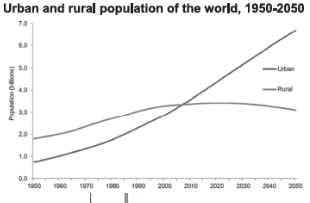
- Rural Population: India and China have the largest rural populations, highlighting the significant urbanization potential and challenges in these countries.
Problems of Urbanization
- Economic Challenges:
- Urban migration creates a saturated labor market, leading to unemployment and underemployment.
- Urban local bodies often lack the finances required for infrastructure development.
- Socio-Cultural Issues:
- Inadequate social infrastructure fails to meet the needs of the growing urban population.
- Overcrowding and lack of hygiene exacerbate health problems and contribute to higher crime rates.
- Environmental Concerns:
- Inadequate water supply and pollution from industrial and domestic sources severely impact urban environments.
- Air pollution, particularly in cities like Delhi, poses significant health risks.
- Inefficient Transportation:
- The rapid increase in automobile usage overwhelms urban transportation systems.
- Lack of integrated public transportation services hinders efficient commuting.
- Slums and Squatter Settlements: A significant portion of urban populations lives in substandard housing conditions, contributing to social and health issues.
- Lack of Disaster Preparedness:
- Urban areas are vulnerable to natural and man-made disasters due to high population densities and unplanned construction.
- The concentration of industries in certain cities exacerbates these challenges, highlighting the need for disaster-oriented urban planning.
Urbanization Issues and Measures in India
Over-Urbanization
Over-urbanization describes the rapid expansion of urban areas, often at the expense of rural and traditional community characteristics. This phenomenon is characterized by:
- Expansion of urban activities and occupations.
- Greater influx of secondary functions like industry.
- Increased sophistication and mechanization of life.
- Influx of urban characteristics into nearby rural areas.
Cities like Delhi and Mumbai are prime examples, where the rapid growth leads to problems like congestion, pollution, and strain on infrastructure.
Sub-Urbanization
Sub-urbanization is closely related to over-urbanization and typically occurs when city populations become overly dense. This leads to:
- The urbanization of rural areas closes to urban centers.
- Significant increase in urban (non-agricultural) uses of land.
- Inclusion of surrounding areas within municipal limits.
- Intensive communication between town and surrounding areas.
A typical example is the expansion of Delhi’s suburbs.
De-Urbanization or Counter-Urbanization
Counter-urbanization involves people moving from urban to rural areas, often as a response to urban problems like congestion and pollution. This process is characterized by:
- Movement from urban to rural areas for employment opportunities and simpler lifestyles.
- A response to inner-city deprivation.
Measures Taken by India to Address Urbanization Problems
The Indian government has implemented various strategies to manage the challenges of urbanization, aiming to harness the demographic dividend and promote sustainable development.
- Developing Rural Infrastructure and Economy: Initiatives like the National Rural Livelihood Mission (NRLM) and the National Rurban Mission aim to make rural economies viable and reduce migration to urban areas.
- Efficient Public Transport and Traffic Management: Projects related to metro, rapid bus systems, and monorails are designed to bolster public transport networks and reduce urban congestion.
- Affordable Housing and Slum Development: Programs like the Pradhan Mantri Awas Yojana aim to provide affordable housing for urban poor and slum dwellers.
- Urban Poverty and Unemployment: Initiatives like the Deendayal Upadhyaya Antyodaya Yojana focus on reducing urban poverty by providing self-employment opportunities and skill training.
- Urban Pollution: Measures include moving polluting factories out of city limits, using low-emission fuels, increasing green belts, and implementing the National Air Quality Index.
- Sewage and Waste Disposal: New regulations and innovative methods for sewage treatment and solid waste management aim to improve urban sanitation.
- Energy Consumption and Generation: Initiatives like GRIHA Ratings and UJALA promote efficient energy use and sustainable electricity generation through rooftop solar panels.
- Transit Oriented Development (TOD): The renovation of New Delhi Railway Station using the TOD concept aims to integrate land use with transportation planning to reduce the need for long-distance travel within cities.
- Development of Counter Magnet Cities: To relieve pressure on metropolitan areas and promote balanced regional development, the concept of Counter Magnet Cities has been introduced.
15th Finance Commission’s Recommendations on Urbanization
The 15th Finance Commission of India has made significant recommendations regarding urbanization, reflecting the growing importance of urban areas in the country’s development. These recommendations aim to address the challenges of rapid urbanization and to ensure sustainable and inclusive growth of urban local bodies (ULBs).
Recommendations
- Increased Grants for Urban Local Authorities: The Commission recommends increasing the proportion of urban local authorities receiving grants from the Finance Commission to 40% over the medium term. This is in recognition of the growing urbanization and the need for enhanced financial support to manage its consequences.
- Differentiated Treatment for Mega Cities: Acknowledging the unique challenges and opportunities presented by the agglomeration effect in mega cities, the Commission suggests differentiated treatment for cities with populations exceeding fifty million. This approach aims to address the rapid growth and complex urban challenges these cities face.
- Focus on Environmental and Sanitation Issues: Special attention is recommended for addressing critical issues such as poor ambient air quality, groundwater depletion, and inadequate sanitation facilities. These are common problems in urban areas that significantly impact public health and the environment.
- Performance-based and Health Grants: The Commission proposes performance-based grants for the development of new cities and health grants to local governments. This incentivizes the adoption of best practices in urban planning and management, and ensures focus on health infrastructure.
- Basic Grants for Smaller Cities: Cities and towns with a population of less than a million are proposed to receive basic grants, emphasizing the need to support smaller urban centers in their development efforts.
- All-time High Allocations: A record allocation of Rs 1,21,055 crore for ULBs for 2021-26 is recommended, along with additional allocations for health emergencies, incubation of towns, and shared service centers. This substantial financial support underscores the importance of urban local bodies in India’s overall development strategy.
- Million-Plus Cities Challenge Fund: A specific allocation of Rs 38,196 crore is designated for Urban Agglomerations and towns to stimulate economic growth and address urban challenges through the Million-Plus Cities Challenge Fund. Grants under this fund are performance-linked, ensuring accountability and encouraging efficiency.
Way Forward
- Sustainable and Eco-friendly Urban Development: The government is urged to boost initiatives that promote smart, secure, environmentally friendly, and affordable cities. Legal backing for these initiatives is also recommended to ensure their effectiveness and sustainability.
- Inclusive Access: Ensuring equal access to all services without discrimination is crucial. This includes developing inclusive infrastructure that accommodates people with disabilities, promoting social equity in urban areas.
- Encouraging Private Investment for Employment: The Commission advocates for private investments in sustainable environmental resource use and job creation. This approach aims to mitigate the adverse effects of urbanization while preserving natural ecosystems.
- Health and Population Management: Population control measures are emphasized as essential for preventing disease spread and ensuring universal access to medical facilities. Managing population growth is linked to creating healthier urban societies.
- Poverty Alleviation: A bottom-up strategy is suggested to understand and address the challenges faced by the urban poor. This approach focuses on tailoring interventions to the specific needs of disadvantaged urban populations.
Concept of Sustainable Urbanization
Sustainable urbanization focuses on the long-term viability of cities by promoting practices that reduce consumption, waste, and negative impacts on both people and the environment. It aims at enhancing the well-being of urban dwellers and preserving the natural and built environment. A sustainable city provides for its citizens’ basic needs — including infrastructure for civic amenities, healthcare, housing, education, transportation, employment — while paying close attention to environmental sustainability, equity, and future generations.
Characteristics of a Sustainable City (According to the United Nations World Economic and Social Survey 2013)
- Resource Efficiency: Cities should meet their residents’ needs without exerting unsustainable pressures on regional or global natural resources and systems.
- Risk Management: They should not transfer risks across space or time.
- Integrated Development: Sustainable cities integrate socio-economic development with environmental management and urban governance.
- Inclusivity and Resilience: They aim to be inclusive, safe, resilient, and sustainable, aligning with the UN Sustainable Development Goal 11.
What is Sustainable Urban Planning?
- Sustainable urban planning is a comprehensive approach that guides the development and design of urban areas. It seeks to increase sustainability, efficiency, and equity through planning across all levels of governance. It involves various disciplines like architecture, engineering, environmental science, and more, creating innovative methods to mitigate the impact of land use on natural resources.
Need for Sustainable Urbanization in India
- With India’s urban population expected to exceed 50% by 2050, sustainable urbanization is crucial. The rapid urbanization, unsustainable city growth, migration, and uneven economic development pose significant challenges, including vulnerability to climate change, urban flooding, and resource depletion. Sustainable urban development is imperative to address these challenges effectively.
Promoting Sustainable Cities: Strategies and Actions
- Inclusive Planning: Urban planning should address diverse needs, supporting mixed traffic, housing, and walkable areas.
- Water Harvesting Infrastructure: To mitigate climate change impacts and urban flooding risks, cities should invest in local water harvesting and enhance urban green spaces.
- Rethinking Western City Concepts: The intensive resource and energy use of Western urban models need reevaluation. Emphasizing passive architectural principles can help achieve thermal comfort more sustainably.
- Developing Smart Villages: Parallel to creating sustainable cities, developing smart villages with access to healthcare, education, and employment is essential. Leveraging technology in design, delivery, and monitoring services can significantly enhance the quality of life in rural and peri-urban areas.
- Improving Public Services for Migrants: The government should ensure that the low-income migratory population has access to basic healthcare and efficient employment markets.
- Implementing Welfare Programs: Programs like MGNREGA that discourage urban migration can be a model for preventing excessive urban population growth. Expanding social safety nets in response to climate change and other challenges is also vital.
Comprehensive Overview of Town Planning
- Town planning is an interdisciplinary approach that integrates social, economic, environmental, and constructional efforts to foster a livable, healthy environment for urban inhabitants. It encompasses a broad range of activities, including policy formulation, regulation, and the implementation of strategies aimed at the inclusive and sustainable development of urban areas. This field is crucial for managing the complexities of urban growth and ensuring that cities are places where people can live, work, and move around comfortably and efficiently.
The Necessity of Town Planning
- Urban Population Growth: The urgency for effective town planning is underscored by the rapid increase in urban populations. According to the 2011 Census, about 31% of Indians lived in urban areas. This figure rose to 34% by 2019 and is expected to continue growing. The burgeoning urban population necessitates forward-looking plans to accommodate this growth sustainably.
- Response to Industrialization: The origins of modern town planning are closely tied to mitigating the negative impacts of the Industrial Revolution on urban dwellers. Industrialization brought about significant social and physical challenges, including overcrowded living conditions, pollution, and inadequate infrastructure. Town planning emerged as a critical field to address these issues, aiming to improve the quality of urban life.
Core Aspects of Town Planning
- Policy Formulation: Town planning involves the development of policies that guide the physical development of urban areas. These policies are designed to ensure that development is balanced, sustainable, and meets the needs of the urban population. They cover various aspects, including land use, housing, transportation, and public spaces.
- Regulation: A key component of town planning is the establishment of regulations that govern urban development. These regulations set standards for building, zoning, and land use that help to organize the urban environment effectively. They ensure that development is consistent with the overall vision for the city and protects the interests of all residents.
- Implementation Strategies: Implementing town planning policies and regulations requires comprehensive strategies that translate vision into reality. This includes the allocation of resources, coordination among various stakeholders, and the execution of development projects. Implementation strategies must be flexible and adaptable to changing urban dynamics.
- Inclusive and Sustainable Development: The ultimate goal of town planning is to achieve inclusive and sustainable urban development. This means creating urban spaces that are accessible to all residents, regardless of socio-economic status, and that preserve environmental resources for future generations. It involves integrating principles of sustainability into all aspects of urban development, from transportation systems to energy use and green spaces.
Planned Cities in India
Planned cities are developed based on pre-determined layouts, emphasizing sustainability, efficient public services, and quality of life. Unlike cities that evolve organically, planned cities are designed with specific objectives, such as improving livability, managing resources effectively, and ensuring equitable access to amenities.
| City | State | Planned By | Notable Features | Benefits |
| Chandigarh | Haryana | Le Corbusier (Swiss-French architect and urban planner) | First planned city post-India’s independence.
– Known for its urban planning and architecture. Divided into 56 sectors, each measuring 800m x 800m. Renowned as India’s wealthiest city. Emphasizes modern amenities and community living. |
High quality of life with natural open spaces.
Efficient public transportation leading to reduced traffic congestion Fair distribution of services and amenities. Clean air and water quality. Protects lower income families from marginalization. |
| Gandhinagar | Gujarat | H.K. Mewara and assistant Prakash M Apte | Capital of Gujarat, located on the western bank of the Sabarmati River.
Known as the “greenest” city in the world due to its numerous parks and gardens. Planned with specific zones for residential, commercial, educational purposes, and the IT industry. Features service lanes on most roads to avoid traffic congestion. |
Emphasis on green living and environmental diversity.
Effective resource management. Proper distribution of public facilities, including hospitals and schools. Avoids traffic congestion through well-planned road infrastructure. |
Benefits of Planned Cities
- Quality of Life: The deliberate design ensures ample natural spaces, promoting a healthier lifestyle.
- Equity in Service Distribution: Services like water, electricity, and waste management are evenly distributed, ensuring all residents have access to essential utilities.
- Traffic and Transport Efficiency: Strategic planning of public transport systems reduces traffic congestion and pollution.
- Environmental Sustainability: Emphasis on green spaces and efficient resource management contributes to cleaner air and water.
- Inclusive Urban Policy: Planning can prevent the marginalization of lower-income groups, ensuring they have access to employment opportunities and amenities.
Concept of Primate City
- The concept of the primate city is a crucial framework in urban geography and city planning, offering insights into the socio-economic development and urbanization patterns of a country. This concept, proposed by Mark Jefferson, serves as a benchmark for evaluating a nation’s level of development through the characteristics of its urbanization.
- Definition and Characteristics
- Empirical Inductive Model: The primate city concept is derived from empirical observations and studies conducted across 51 countries, making it an inductive model based on real-world data and experiences.
- Disproportionate Development: A primate city is distinguished by its disproportionate size and development relative to other cities within the same country. It emerges as the largest and most dominant urban settlement, overshadowing others in terms of population, economic activity, political power, and industrial growth.
- Centripetal Economic Opportunities: The development of a primate city is driven by centripetally based economic opportunities, which attract resources, investments, and population from surrounding areas and even nationwide.
- Population Benchmark: For a city to be considered a primate city, its population must be at least twice that of the next largest city in the country. This criterion underscores the significant gap between the primate city and other cities in terms of size and influence.
- Exceptions and Variations
- India: With megacities like Mumbai, Delhi, Kolkata, and Chennai, India demonstrates a more distributed urban hierarchy rather than a single dominant primate city. Factors such as the country’s vast size, colonial heritage, and regional disparities contribute to this phenomenon.
- Australia and Canada: Countries like Australia and Canada also have multiple major cities (e.g., Sydney and Melbourne in Australia; Toronto and Montreal in Canada) that coexist without a clear primate city dominating the urban landscape.
- Significance of Primate Cities
- Economic Magnets: Primate cities act as major economic centers, drawing resources and human capital from their hinterlands and beyond, exemplifying cities like London and New York.
- Reflection of National Aspirations: These cities often embody the socio-economic aspirations of their population, serving as hubs of opportunity, innovation, and national identity.
- Urban Planning and Policy Implications: Understanding the dynamics of primate cities is essential for urban planners and policymakers. It helps in crafting strategies for balanced regional development, infrastructure investment, and mitigation of urban sprawl.
Rural-Urban Continuum and Urban Sprawl
Rural-Urban Continuum
- Concept Overview
- The Rural-Urban Continuum highlights the gradation between purely rural communities and fully urbanized societies. It challenges the binary view of rural vs. urban, suggesting instead a spectrum where lifestyles and community structures blend aspects of both.
- Theory and Distinctions
- Proponents of the continuum theory argue that the differences between rural and urban areas exist in degrees, with various settlements embodying characteristics of both to varying extents. This perspective recognizes the fluidity of urbanization, acknowledging that communities evolve in diverse ways.
Urban Sprawl
- Definition and Characteristics: Urban Sprawl refers to the unchecked expansion of urban areas, characterized by low-density residential development, reliance on private automobiles, and single-use zoning. This phenomenon is marked by the spread of urban infrastructure into peripheral areas, often at the expense of natural and agricultural lands.
- Indian Context: India has witnessed significant urban sprawl, driven by population growth and migration. Cities like Chennai have seen their urban areas expand dramatically, leading to the encroachment on forests, mangroves, and agricultural lands. This expansion raises concerns about sustainability and environmental degradation.
Types of Urban Sprawl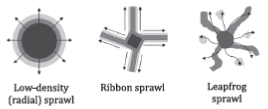
- Continuous Sprawl: The outward spread of low-density suburban land use, common in cities with growing populations.
- Ribbon Sprawl: Development concentrated along transportation corridors, leaving undeveloped green spaces in between.
- Leapfrog Sprawl: Scattered urbanization with patches of developed land interspersed with green spaces, influenced by topographical constraints and development policies.
Causes of Urban Sprawl
- Push Factors
- Lack of Urban Planning: Inadequate planning leads to chaotic development and environmental issues.
- Absence of Regulatory Frameworks: The lack of strict urban planning laws facilitates random and uncontrolled expansion.
- Population Growth: Increasing population pressures cities to expand outward.
- Environmental Pollution: Pollution in urban centers drives people to seek residence in peripheral areas.
- Pull Factors
- Affordable Land: Lower land prices in suburban areas attract residents away from city centers.
- Improved Infrastructure: Investments in infrastructure outside urban centers make these areas more appealing.
- Higher Standard of Living: Rising incomes enable people to afford homes in low-density areas.
- Lower Taxes: Suburban areas often have lower property taxes compared to urban centers.
Challenges and Advantages of Urban Sprawl
- Challenges
- Environmental Impact: Urban sprawl contributes to habitat disruption, pollution, and loss of green spaces.
- Unsustainable Living: Increased reliance on automobiles worsens air quality and depletes fossil fuels.
- Infrastructure Strain: Expansion puts pressure on infrastructure, leading to traffic congestion and accidents.
- Advantages
- Economic Growth: Sprawl can spur economic activity and job creation in suburban areas.
- Policy-making Assistance: Identifying growth areas can aid in targeted development initiatives.
- Housing Opportunities: Sprawl provides potential for affordable housing, though this requires complementary transport solutions.
- Measures for Sprawl Reduction
- Growth Limits: Implementing urban growth boundaries and zoning restrictions can control sprawl.
- Incentivizing Urban Density: Encouraging development in urban centers through tax incentives and development rights.
- Infrastructure Policies: Directing public investment to designated areas can guide urban expansion responsibly.
- Land Acquisition: Protecting ecologically sensitive areas through purchases and conservation easements.
- Educational Programs: Raising awareness about the impacts of sprawl and promoting sustainable development practices.
Urban Heat Islands
Urban Heat Islands (UHIs) represent a significant environmental challenge, particularly in densely populated cities. These phenomena lead to higher temperatures in urban areas compared to their rural surroundings, primarily due to human activities and architectural designs.
Causes of Urban Heat Islands
- Lack of Evapotranspiration: Urban areas, with their sparse greenery, exhibit reduced evapotranspiration, contributing to higher temperatures.
- Urban Architecture: The Urban Canyon Effect, caused by narrow streets and tall buildings, obstructs airflow, reducing natural cooling.
- Air Conditioning: The extensive use of air conditioning in buildings with dark surfaces necessitates more energy, contributing to local heat and pollution.
- Construction Activities: The proliferation of asphalt and concrete for infrastructure absorbs and retains heat, elevating urban temperatures.
- Dark Surfaces: Urban areas often feature buildings with dark surfaces that absorb more heat, further exacerbating UHI effects.
- Lack of Greenery: The absence of trees and vegetation limits shade, carbon dioxide absorption, and natural cooling processes.
- Increased Vehicle Use: The reliance on private vehicles and fossil fuels for transportation adds to urban warmth.
Impact of Urban Heat Islands
- Energy Consumption: UHIs increase the demand for energy, particularly for cooling, leading to higher pollution levels and health-related issues.
- Water Quality: The influx of warm water from urban areas into streams stresses aquatic life adapted to cooler environments.
- Air Quality: Higher temperatures in cities contribute to elevated pollution levels, affecting air quality.
- Heatwaves: The intensity and frequency of heatwaves are amplified in urban areas, impacting human and animal health.
- Biological Changes: UHIs favor species that thrive in warmer conditions, altering local biodiversity.
Solutions to Mitigate Urban Heat Islands
- Increase Green Cover: Expanding urban greenery through planting trees and vegetation can significantly reduce heat.
- Passive Cooling Technology: Implementing passive cooling designs in buildings can enhance natural ventilation and reduce reliance on air conditioning.
- Replace Dark Surfaces: Replacing dark roofs and pavements with lighter-colored materials can reflect more sunlight, reducing heat absorption.
- Green Building Standards: Adopting green building practices can make structures more sustainable and environmentally friendly.
- Mitigating the effects of Urban Heat Islands requires a multifaceted approach involving urban planning, architectural design, and community engagement. By incorporating more green spaces, utilizing passive cooling technologies, and embracing sustainable construction practices, cities can significantly reduce the impact of UHIs. These efforts not only improve the urban environment but also enhance the quality of life for its inhabitants, ensuring a sustainable and livable future for urban areas.
UPSC PREVIOUS YEAR QUESTIONS
1. How is efficient and affordable urban mass transport key to the rapid economic development of India? (2019)
2. “The ideal solution of depleting ground water resources in India is water harvesting system.” How can it be made effective in urban areas? 2018
3. The growth of cities as I.T. hubs has opened up new avenues employment but has also created new problems. Substantiate this statement with examples. Urbanization (2017)
4. With a brief background of quality of urban life in India, introduce the objectives and strategy of the ‘Smart City Programme’. (2016)
5. Discussion the various social problems which originated out of the speedy process of urbanization in India. (2013)