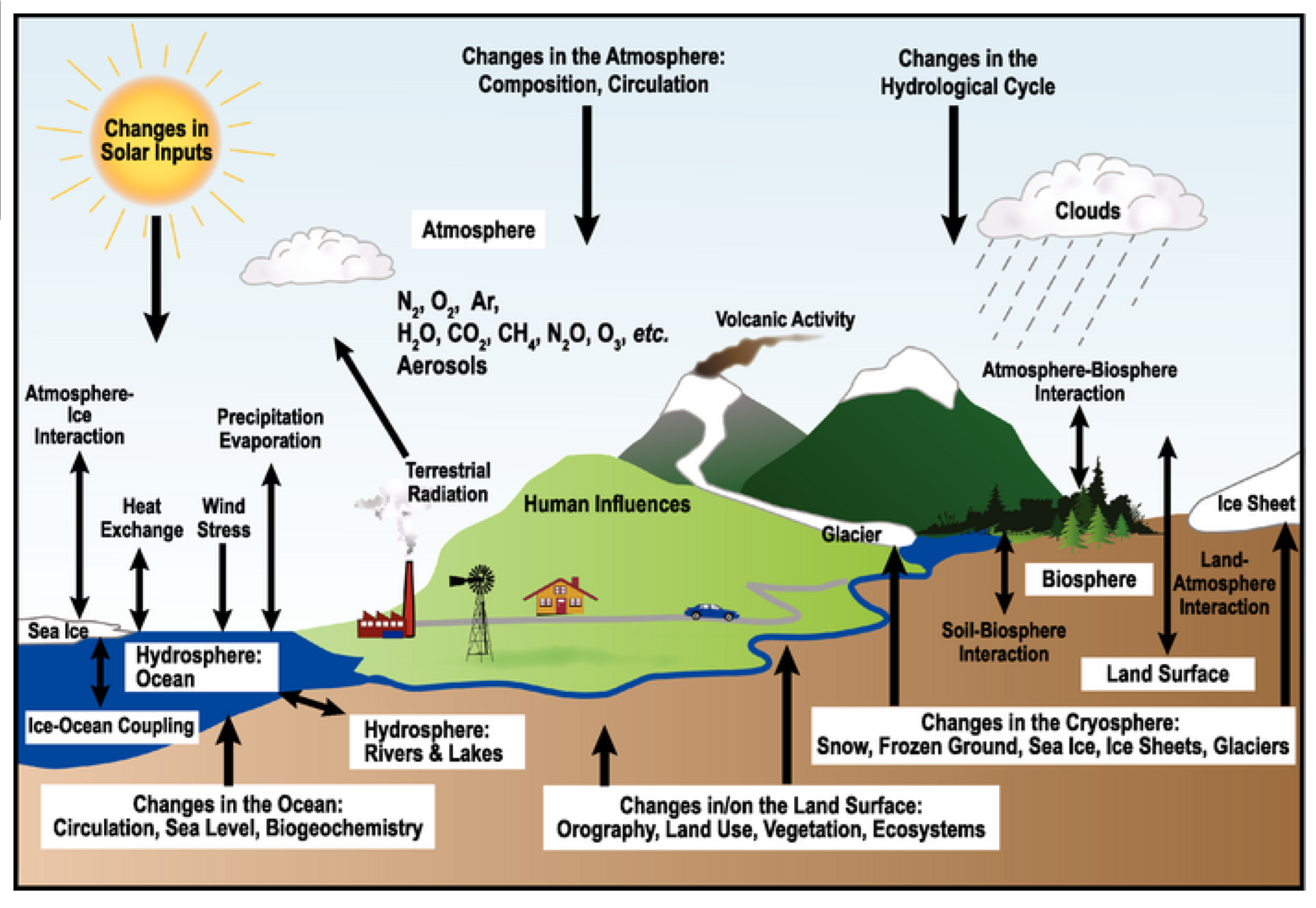
CLIMATOLOGY
Atmosphere and Its Composition
The atmosphere is an intricate and dynamic layer of gases that envelops the Earth, playing a crucial role in sustaining life and influencing global climate patterns. Understanding its composition, structure, and the forces that shape it is fundamental to meteorology, environmental science, and climatology.
Definition and Composition
The atmosphere is a mixture of gases, water vapor, and particles that surrounds the Earth. It extends from the Earth’s surface to the edge of space, gradually thinning until it fades into the vacuum. The primary gases in the atmosphere by volume are nitrogen, oxygen, argon, carbon dioxide, neon, helium, krypton, and hydrogen, among others. Water vapor and dust particles are also significant constituents, varying in concentration depending on location and weather conditions.
Structure and Shape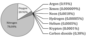
The atmosphere is not a uniform layer but is structured into several concentric layers, each with distinct characteristics in terms of temperature, chemical composition, and physical properties. These layers, from closest to farthest from the Earth’s surface, include the troposphere, stratosphere, mesosphere, thermosphere, and exosphere. The shape of the atmosphere is spheroidal, influenced by the Earth’s rotation, which causes it to bulge at the Equator and flatten at the poles. This oblate spheroid shape results from the balance between gravitational forces pulling gases toward the Earth’s center and centrifugal forces pushing them outward due to the planet’s rotation.
Atmospheric Composition Table
The table below summarizes the major gases in the Earth’s atmosphere, their percent by volume, and their concentrations in parts per million (PPM):
| Constituent | Percent by Volume | Concentrations in PPM |
| Nitrogen (N2) | 78.084% | 780,840 |
| Oxygen (O2) | 20.946% | 209,460 |
| Argon (Ar) | 0.934% | 9,340 |
| Carbon Dioxide (CO2) | 0.036% | 360 |
| Neon (Ne) | 0.00182% | 18.2 |
| Helium (He) | 0.000524% | 5.241 |
| Krypton (Kr) | 0.000114% | 1.14 |
| Hydrogen (H2) | 0.00005% | 0.5 |
Gravity’s Role
Gravity is pivotal in maintaining the atmosphere’s structure and composition. It pulls gas molecules toward the Earth’s surface, preventing them from drifting into space. The force of gravity not only holds the atmosphere in place but also influences the distribution and density of gases at different altitudes. Heavier gases, like oxygen and nitrogen, are more concentrated near the surface, while lighter gases, such as helium and hydrogen, are found at higher altitudes.
Major Components of Air
| Type | Components |
| Permanent Gas | Nitrogen |
| Oxygen | |
| Argon | |
| Neon | |
| Helium | |
| Hydrogen | |
| Xenon | |
| Variable Gas | Water Vapour |
| Carbon Dioxide (CO2) | |
| Methane (CH4) | |
| Nitrous Oxide (N2O) | |
| Ozone (O3) | |
| Particles | |
| Chlorofluorocarbons (CFCs) |
Permanent Gases
Oxygen (O2)
- Description: Oxygen is a critical element for respiration and combustion processes. It is a vital component of many organic molecules, including carbohydrates, proteins, and fats, which are essential for the life of organisms.
- Applications:
- Biological: Essential for the aerobic respiration of all aerobic organisms.
- Recreational: Used by scuba divers and mountaineers to aid breathing in environments where oxygen levels are insufficient.
- Industrial: Utilized in the smelting of iron ore into steel due to its role in combustion.
- Medical and Recreational: Oxygen bars offer concentrated oxygen for its mild euphoric effects.
Nitrogen (N2)
- Description: Nitrogen is the most abundant component of air, making up about 78% by volume. It is integral to the nitrogen cycle, a critical process for life on Earth, involving nitrogen fixation to become usable by living organisms.
- Applications:
- Agricultural: Artificial nitrogen is a key component of fertilizers, enhancing plant growth.
- Industrial: Produced industrially by the fractional distillation of liquid air, used in various applications.
- Medical: Employed in certain drugs and antibiotics.
- Safety Note: While non-toxic, nitrogen can displace oxygen in enclosed spaces, potentially causing asphyxia.
These tables and descriptions aim to provide a clearer and more detailed understanding of the major components of air and the specific roles and applications of permanent gases like oxygen and nitrogen.
Variable Gases
| Gas | Description |
| Carbon Dioxide | · Trace gas with a concentration of about 0.04%
· Produced through respiration and decomposition of organic materials · Other production methods include natural sources like geysers, volcanoes, and hot springs, and by the combustion of petroleum and natural gases · Applications include use for quenching fire, as an important ingredient for the production of fertilizers (Urea), and as a refrigerant during transportation as well as storage of frozen foods · Increases in CO2 emissions from human activities like deforestation, burning of fossil fuels, and industrialization |
| Argon | · The third most abundant element in the atmosphere (0.93%)
· Colorless, tasteless, and odorless gas · Produced industrially by fractional distillation of liquid air · Used to provide an unreactive atmosphere, e.g., in graphite furnaces to prevent combustion · Medical use includes being used as a blue laser to cure eye defects and destroy tumors |
| Water Vapor | · Concentration varies from about 0.01% to 4.24% in the atmosphere, depending on temperature
· Received through evaporation from water bodies, vegetation, and soil cover · Key factor for vapor, decreasing from the equator to poles with temperature · Over 90% of atmospheric vapor found up to 5 km altitude · Contributes to the Greenhouse effect by absorbing and emitting radiation · Used in hot air balloons as a lifting gas due to its lower density than air |
| Dust Particles | · Consist of fine solid particles from volcanic eruptions, pollution, or soil, including pollens, human and animal hair, and soot in small amounts
· Can clog automobile filters, reduce visibility, cause respiratory diseases, and have allergic effects · Methods to reduce include using air filtering appliances, dust-resisting materials, and vacuum cleaners |
| Ozone | · Found between 10 and 50 km above the earth’s surface
· Filters and absorbs UV radiation, preventing these rays from reaching the earth’s surface · Occurs in the stratosphere, in limited amounts |
Current Updates on Ozone Layer
The ozone layer, a critical component of the Earth’s atmosphere, plays a vital role in absorbing the majority of the sun’s harmful ultraviolet (UV) radiation. This layer is found in the lower portion of the stratosphere from about 10 to 30 kilometers above Earth, acting as a shield that protects life on the planet from excessive UV radiation. The health of the ozone layer has been a global concern for decades, especially after the discovery of the Antarctic ozone hole in the 1980s. Since then, international efforts like the Montreal Protocol have aimed to reduce the emission of ozone-depleting substances (ODS).
World Ozone Day: 16 September
World Ozone Day, celebrated on September 16, marks the date of the signing of the Montreal Protocol on Substances that Deplete the Ozone Layer in 1987. This day is dedicated to raising awareness about the depletion of the ozone layer and promoting actions to protect it. The protocol has been successful in phasing out the production and consumption of ODS, leading to significant recovery signs in the ozone layer.
Tropical Ozone Hole: A New Concern
Recently, researchers have detected a new ozone hole over the tropics, an area extending between latitudes of 30 degrees south to 30 degrees north. This discovery is alarming for several reasons:
- Size and Impact: The tropical ozone hole is reported to be almost seven times larger than the well-known hole over Antarctica. This significant size means it covers a vast area, making up almost 50% of Earth’s surface. Given the tropics’ extensive coverage, the potential for global impact is high, affecting millions of people and diverse ecosystems.
- Health and Environmental Risks: The depletion of ozone in this region poses serious health risks, including an increased incidence of skin cancer, cataracts, and other UV-related health issues. The high UV exposure can also negatively affect agricultural productivity and disrupt marine ecosystems, including phytoplankton populations at the base of the ocean food chain.
- Global Concern: The existence of a tropical ozone hole is a matter of global concern. The tropics are home to a significant portion of the world’s population, and the potential health risks, coupled with environmental impacts, underscore the urgency of addressing this issue. It emphasizes the need for continued vigilance in monitoring ozone depletion and the importance of adhering to and potentially strengthening international agreements like the Montreal Protocol.
Implications and Actions
The discovery of the tropical ozone hole highlights the need for ongoing research and monitoring of the Earth’s ozone layer. Scientists are working to understand the causes of this depletion, which could include both natural variability and human-made factors. It also reinforces the importance of international cooperation in managing and mitigating the effects of ozone depletion.
- Mitigation Efforts: Strengthening global efforts to reduce ODS emissions is crucial. Although the Montreal Protocol has significantly reduced the production of many harmful chemicals, vigilance is necessary to ensure compliance and to address any emerging threats to the ozone layer.
- Research and Monitoring: Enhanced research efforts are needed to fully understand the dynamics of the tropical ozone hole. This includes studying the atmospheric processes affecting ozone levels and assessing the impact of climate change on the ozone layer.
- Public Awareness and Health Measures: Increasing public awareness about the risks associated with increased UV exposure is vital. This includes promoting protective measures such as wearing sunscreen, sunglasses, and protective clothing, as well as implementing public health initiatives to monitor and mitigate the impacts of UV exposure.
Contribution of Polar Stratospheric Clouds for Ozone Depletion
Polar Stratospheric Clouds (PSCs), also known as nacreous clouds, play a significant role in the depletion of the ozone layer, particularly over the polar regions. These clouds form in the stratosphere at altitudes of about 15 to 25 kilometers, under extremely cold temperatures below -78°C (-108°F). PSCs contribute to ozone depletion through complex chemical processes, which can be outlined in two primary ways:
1. Conversion of Benign Chlorine Compounds into Reactive Forms
PSCs provide a surface for chemical reactions that convert chlorine-containing compounds, which are benign in their reservoir forms (such as chlorine nitrate (ClONO2) and hydrochloric acid (HCl)), into reactive chlorine gases (such as Cl2 or HOCl). When sunlight returns to the polar regions after the polar night, these chlorine gases are photolyzed, releasing chlorine atoms (Cl) and chlorine monoxide radicals (ClO), which are highly effective in catalyzing the destruction of ozone (O3).
2. Removal of Nitrogen Compounds
Nitrogen compounds in the stratosphere, such as nitric acid (HNO3), play a moderating role in the ozone depletion process by forming stable compounds with chlorine, thus reducing the amount of reactive chlorine available for ozone destruction. PSCs facilitate the removal of these nitrogen compounds by incorporating them into the cloud particles. When these particles fall out of the stratosphere (a process known as denitrification), the balance shifts towards a more aggressive depletion of ozone due to an increase in the availability of reactive chlorine species.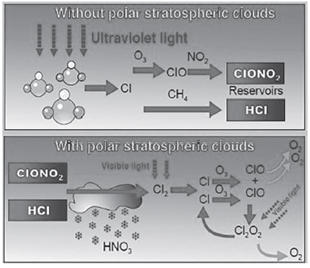 Impact of Colder Arctic Temperatures
In recent years, the atmosphere above the Arctic Ocean has experienced colder than normal temperatures, leading to the more frequent formation of PSCs and their persistence into the spring season. This extended presence of PSCs contributes to a longer period of ozone depletion each year. The colder temperatures and prolonged duration of PSCs mean that the conditions conducive to ozone depletion are present for a longer time, exacerbating the reduction in ozone levels above the Arctic.
Mechanism for Ozone Depletion Enhanced by PSCs
The mechanism by which PSCs enhance ozone depletion involves several steps:
- Formation of PSCs: These clouds form under extremely cold stratospheric conditions and consist of water, nitric acid, and/or sulfuric acid. Their composition can vary, leading to different types of PSCs, each playing a role in ozone depletion chemistry.
- Activation of Chlorine Compounds: On the surface of PSCs, chlorine reservoir compounds are converted into more reactive forms that can easily participate in ozone-depleting reactions.
- Catalytic Ozone Destruction: Reactive chlorine and bromine species catalyze a chain reaction that leads to the rapid destruction of ozone. For chlorine, the basic reactions can be simplified as follows:
- Cl + O3 → ClO + O2
- ClO + O → Cl + O2 These reactions result in the net destruction of ozone (O3) and atomic oxygen (O), converting them into molecular oxygen (O2) without consuming the chlorine atom, allowing it to destroy more ozone molecules in a catalytic cycle.
The presence of PSCs and the resulting chemistry are critical factors in the seasonal ozone hole phenomena observed over the Antarctic and, increasingly, over the Arctic. International efforts to reduce the emission of ozone-depleting substances have been successful in slowing the rate of ozone layer depletion. However, the natural processes involving PSCs in the polar stratospheres highlight the complexity of atmospheric chemistry and the challenges in managing and predicting the recovery of the ozone layer.
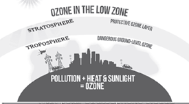
The discussion surrounding the ozone layer, its depletion, and the distinction between “good” and “bad” ozone, is crucial for understanding environmental science and global ecological health.
Ozone Hole
The term “ozone hole” refers to a significant reduction in the concentration of ozone in the stratosphere, particularly above the polar regions of Antarctica and, to a lesser extent, the Arctic. This phenomenon is primarily caused by the release of ozone-depleting substances (ODS) into the atmosphere, which include:
- Chlorofluorocarbons (CFCs)
- Halons
- Carbon Tetrachloride (CCl4)
- Carbon Tetrafluoride (CF4)
- Hydrochlorofluorocarbons (HCFCs)
- Methyl Bromide
- Methyl Chloroform
These compounds, once released into the atmosphere, can persist for years to decades. They eventually reach the stratosphere, where they are broken down by ultraviolet (UV) light, releasing chlorine and bromine atoms. These atoms then catalyze reactions that destroy ozone molecules.
It’s essential to understand that the ozone is not evenly distributed in a single layer across the stratosphere but is instead more concentrated in certain regions, forming what is commonly referred to as “the ozone layer.” This layer varies in density and thickness across different parts of the globe and at different times of the year.
Good and Bad Ozone
The differentiation between “good” and “bad” ozone is based on its location in the Earth’s atmosphere and the effects it has on living organisms and the environment:
- Good Ozone: Found in the stratosphere, this ozone forms a layer approximately 10 to 30 kilometers above the Earth’s surface and plays a critical role in absorbing the majority of the sun’s harmful ultraviolet radiation. Without this protective layer, life on Earth would be exposed to significantly higher levels of UV radiation, leading to increased rates of skin cancer, cataracts, and other health issues, as well as damaging sensitive ecosystems.
- Bad Ozone: At ground level in the troposphere, ozone is not emitted directly but is formed through chemical reactions between oxides of nitrogen (NOx) and volatile organic compounds (VOC) in the presence of sunlight. This type of ozone is a major component of smog and poses serious health risks, including respiratory problems, heart diseases, and can exacerbate conditions like asthma. It also has detrimental effects on crops and other vegetation.
Addressing Ozone Depletion
The global response to the threat of ozone depletion has been largely coordinated through the Montreal Protocol on Substances that Deplete the Ozone Layer, an international treaty signed in 1987. The protocol has been successful in phasing out the production and consumption of many ODS, leading to gradual healing of the ozone layer. However, the persistence of existing ODS in the atmosphere and the emergence of new threats require ongoing vigilance and international cooperation.
Structure of An Atmosphere
To expand in depth on the structure of the Earth’s atmosphere, we can detail it in a structured format using a table to encapsulate the different layers based on chemical composition, density, pressure, and temperature variations. The atmosphere is a complex system that is critical for Earth’s climate and life. It is divided into several layers, each with unique characteristics and functions. The division is primarily based on temperature gradients, leading to the classification into the troposphere, stratosphere, mesosphere, thermosphere, and exosphere. These layers collectively form two major zones based on chemical composition: the Homosphere and the Heterosphere.
Structure of the Earth’s Atmosphere
| Layer | Zone | Altitude Range | Characteristics |
| Troposphere | Homosphere | 0 to 12 km | · Lowest layer of the atmosphere
· Contains 75% of the atmosphere’s mass · Weather phenomena occur here · Temperature decreases with altitude |
| Stratosphere | Homosphere | 12 to 50 km | · Contains the ozone layer which absorbs and scatters ultraviolet solar radiation
· Temperature increases with altitude due to ozone absorption of UV radiation |
| Mesosphere | Homosphere | 50 to 80 km | · Meteors burn up in this layer
· Temperature decreases with altitude · Coldest layer of the atmosphere |
| Thermosphere | Heterosphere | 80 to 600 km (approx.) | · Temperature increases with altitude
· Northern and Southern Lights occur here · The air is thin, and gas molecules are far apart |
| Exosphere | Heterosphere | 600 km to 10,000 km | · Upper limit of the atmosphere
· Air is extremely thin · Where the atmosphere merges into space<br>- Satellites orbit in this layer |
- Homosphere: This zone extends up to about 80 km above the Earth’s surface. It is characterized by a relatively uniform composition of gases, primarily nitrogen (N2) and oxygen (O2), along with argon, carbon dioxide (CO2), and trace gases. The homosphere is further divided into three layers: the troposphere, stratosphere, and mesosphere. In this zone, the air composition is homogeneous due to the turbulent mixing of the gases.
- Heterosphere: Above the homosphere, starting at around 80 km, the heterosphere extends to the outer limits of the atmosphere, around 10,000 km. In this zone, the atmosphere’s composition varies with altitude. Gases are sorted by molecular weight under the influence of the Earth’s gravity, with lighter gases like hydrogen and helium found at higher altitudes, and heavier gases such as nitrogen and oxygen found at lower altitudes. The heterosphere is divided into the thermosphere and the exosphere.
- Troposphere: The most dynamic layer where weather occurs. It contains the majority of the Earth’s atmospheric mass. The temperature decreases with altitude, leading to the formation of weather phenomena.
- Stratosphere: Characterized by a temperature inversion, where temperature increases with altitude due to the absorption of ultraviolet radiation by the ozone layer. This layer is relatively stable and contains the ozone layer which protects the Earth from harmful solar radiation.
- Mesosphere: The middle layer of the atmosphere, where temperatures decrease with altitude. It is the layer in which most meteoroids burn up upon entry.
- Thermosphere: In this layer, temperature increases significantly with altitude. The thermosphere is also where the auroras occur, due to the interaction of the Earth’s magnetic field with charged particles from the Sun.
- Exosphere: Considered the outermost layer of the Earth’s atmosphere, the exosphere gradually fades into space. It is composed of extremely low densities of hydrogen, helium, and several heavier molecules including nitrogen, oxygen, and carbon dioxide closer to the lower boundary.
Each layer plays a critical role in Earth’s environment, affecting everything from weather patterns to radio communications. Understanding these layers is crucial for meteorology, environmental science, and space exploration.
Based on Change in Temperature
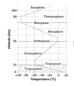
Troposphere: The Dynamic Lower Layer of Earth’s Atmosphere
The troposphere stands as the foundational layer of Earth’s atmosphere, closest to the surface, and plays a pivotal role in the climate and weather systems we experience daily. Its characteristics and dynamics are essential for understanding weather patterns, climate change, and the overall behavior of Earth’s atmosphere.
Height and Structure
- Vertical Extent: The troposphere varies in thickness around the globe—approximately 18km at the equator, 13km at mid-latitudes, and 8km at the poles, with an average height of 13km. This variation is primarily due to the thermal expansion of air near the equator caused by intense solar heating.
- Mass Concentration: About 75-80% of the atmosphere’s mass is contained within the troposphere, highlighting its density compared to the layers above.
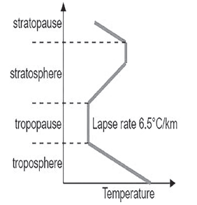
Temperature Gradient and Lapse Rate
- Lapse Rate: Temperature decreases with altitude at a rate of approximately 5°C per kilometer (or 1°C per 165 meters), culminating in minimum temperatures of around -45°C at the poles and -80°C at the equator near the tropopause. This predictable decrease in temperature with altitude is known as the lapse rate.
- Temperature Variations: The significant difference in temperature decrease between the equator and the poles is attributable to the troposphere’s varying thickness. At the equator, where the troposphere is thickest, air is heated more intensely and transported to higher altitudes, resulting in a greater temperature drop by the time it reaches the tropopause.
Meteorological Significance
- Weather Phenomena: The troposphere is the stage for nearly all weather-related activities—rainfall, storms, fog, hail, and more. Its dynamic nature, characterized by temperature inversion, turbulence, and eddies, makes it meteorologically vibrant and significant.
- Convective Activity: Dubbed the convective region, the troposphere houses all vertical air movement (convection), which ceases at the tropopause. It is in this layer that the formation and movement of weather systems like cyclones and anticyclones take place.
- Moisture and Particulates: All water vapor and the majority of atmospheric particulates reside within the troposphere, contributing to cloud formation, precipitation, and various optical phenomena.
Tropopause: The Boundary Layer
- Defining the Upper Limit: The tropopause acts as the ceiling of the troposphere and the boundary with the stratosphere above. Here, the temperature stabilizes and ceases to decrease with altitude, marking a significant atmospheric transition.
- Temperature Stability: At this boundary, temperatures level out at approximately -80°C over the equator and -45°C over the poles. This zone of constant temperature delineates the tropopause from the stratosphere, where temperature trends begin to reverse.
Stratosphere: The Stable Upper Layer of Earth’s Atmosphere
The stratosphere is a critical layer of Earth’s atmosphere, located directly above the troposphere and extending up to approximately 50 kilometers (km) above the Earth’s surface. Its distinct characteristics and the presence of the ozone layer play vital roles in protecting life on Earth and in the dynamics of atmospheric circulation.
Characteristics and Structure
- Altitude and Extent: The stratosphere spreads uniformly around the globe, starting from the tropopause (the boundary between the troposphere and stratosphere) and stretching up to 50km in altitude.
- Temperature Gradient: Unlike the troposphere, where temperature generally decreases with altitude, the stratosphere exhibits a temperature inversion. After a zone where temperatures remain relatively constant, they begin to increase with altitude, reaching up to 0°C at the stratosphere’s upper boundary. This temperature rise is attributed to the absorption of ultraviolet (UV) radiation by the ozone layer, which converts UV energy into thermal energy.
- Ozone Layer: The stratosphere houses the ozone layer, situated approximately 15 to 35km above the Earth’s surface. The ozone molecules (O3) absorb significant amounts of harmful UV radiation from the sun, playing a crucial role in protecting life on Earth by preventing most of this radiation from reaching the ground.
Meteorological and Aviation Significance
- Weather Phenomena: The stratosphere is notably free from the weather phenomena that are common in the troposphere, such as clouds and storms. This lack of weather activity, combined with the stability of the air, makes the stratosphere ideal for aviation, particularly for commercial jet flights. Aircraft often cruise in the lower stratosphere, especially on long-haul flights, to take advantage of the smoother air and less atmospheric resistance.
- Cloud Formation: While the stratosphere is generally clear of clouds, it can occasionally host thin, wispy cirrus clouds at its lower levels, near the boundary with the troposphere. However, such occurrences are relatively rare compared to the cloud-rich troposphere.
Mesosphere: The Middle Layer of Earth’s Atmosphere
The mesosphere is a key atmospheric layer, sitting above the stratosphere and below the thermosphere, extending from approximately 50 to 80 kilometers (km) above Earth’s surface. It is characterized by decreasing temperatures with altitude and plays a significant role in atmospheric phenomena.
Characteristics and Temperature
- Temperature Decline: As altitude increases within the mesosphere, the temperature decreases, reaching average lows around -90°C at its upper boundary. This makes the mesosphere the coldest layer of Earth’s atmosphere.
- Ion Presence: Near the top of the mesosphere, there exists a layer of ions or charged particles. This ion layer, extending into the thermosphere, is crucial for reflecting radio waves back to Earth, aiding in global telecommunication systems.
Thermosphere: The Upper Atmosphere
Located above the mesosphere, the thermosphere extends from about 80 to 400 km above Earth. This layer is known for its rapid temperature increases with altitude and contains the ionosphere, a region vital for radio communication.
Temperature and Composition
- Temperature Increase: In contrast to the mesosphere, the thermosphere experiences a sharp rise in temperature with increasing altitude. The temperature can get significantly higher, although the exact temperature can vary widely.
- Ionosphere Integration: The ionosphere, part of the thermosphere, is essential for the reflection of radio waves, enabling long-distance radio communication by bouncing signals back to Earth’s surface.
Notable Phenomena
- Low Pressure and Density: Despite high temperatures, the thermosphere’s extremely low pressure and density mean that heat is not felt in the same way as it is on Earth’s surface. This is why astronauts and satellites in this layer do not experience the extreme temperatures directly.
- Auroras: The mesmerizing auroras, or northern and southern lights, occur in the lower parts of the thermosphere. These natural light displays are caused by the interaction of solar wind with Earth’s magnetic field and atmosphere, visible near the polar regions.
Ionosphere: The Electrically Charged Layer
The ionosphere is a crucial layer of Earth’s atmosphere, characterized by its significant electrical conductivity. It spans from the upper mesosphere into the thermosphere, covering altitudes from approximately 80 kilometers (km) to 400 km above the Earth’s surface. This layer plays a pivotal role in atmospheric science and telecommunications.
Characteristics and Functions
- Electrical Charge: The ionosphere contains a high concentration of ions and free electrons, ionized primarily by solar and cosmic radiation, including gamma rays, X-rays, and ultraviolet rays. This ionization process is critical for the layer’s electrical properties.
- Solar and Cosmic Influence: The ionization in the ionosphere is significantly influenced by solar activity, leading to variations in its density and composition. These changes can affect radio wave propagation, impacting telecommunications and navigation systems.
- Thermal Dynamics: As in the thermosphere, the temperature in the ionosphere increases with altitude due to the absorption of solar radiation, contributing to the overall temperature gradient of the upper atmosphere.
Significance for Space Vehicles and Meteorites
- Frictional Heating: The ionosphere is the region where incoming space vehicles and meteorites begin to experience significant heating due to friction with the ionized particles. This heating effect is a critical consideration for the design and operation of spacecraft entering Earth’s atmosphere.
Exosphere: The Boundary of Outer Space
The exosphere represents the outermost layer of Earth’s atmosphere, extending from the top of the ionosphere at about 400 km altitude into space. It is characterized by extremely low densities and serves as the transition zone between Earth’s atmosphere and outer space.
Characteristics and Phenomena
- Rarefied Air: In the exosphere, air molecules are so sparse that they can travel hundreds of kilometers without colliding with one another. This low density means that traditional concepts of temperature and pressure are not applicable in the same way as in lower atmospheric layers.
- Escaping Gases: Light gases, such as helium and hydrogen, are prevalent in the exosphere and can escape into space due to the layer’s proximity to the vacuum of outer space and the kinetic energy of the gas molecules.
- Temperature Variations: The temperature in the exosphere gradually increases with altitude, influenced directly by exposure to the sun’s radiation. However, due to the low density of air, this increase in temperature does not correspond to a noticeable increase in heat for objects or individuals in this layer.
Insolation: An In-depth Exploration
Insolation, an abbreviation for INcoming SOLar radiATION, refers to the solar energy received by the Earth’s surface. This concept is pivotal in understanding Earth’s climate system, weather patterns, and the energy foundation for almost all life forms.
1. Nature of Insolation
- Definition: Insolation is the amount of solar radiation that reaches the Earth’s surface. It comes in the form of electromagnetic waves, primarily in the visible, ultraviolet, and infrared parts of the spectrum.
- Characteristics: The energy from the sun travels through space as short-wave radiation due to its high temperature, which enables these waves to traverse the vast expanse between the Sun and the Earth.
2. Quantification of Insolation
- Measurement Unit: The amount of insolation received by the Earth is measured in Langley (Ly). One Langley equals one gram calorie of solar energy per square centimeter of surface area. It’s a measure that helps scientists quantify and discuss the energy Earth receives over time and across different locations.
- Scale of Energy Received: Despite the Sun emitting a massive amount of energy, only about two-billionths of this total energy reaches the Earth’s surface. This minuscule fraction underscores the vast distance between the Earth and the Sun and the relative smallness of our planet.
3. Journey Through Space
- Transmission: Before insolation reaches the Earth’s surface, it must travel through the vacuum of space. This journey involves no loss of energy in the vacuum, but as it enters the Earth’s atmosphere, the fate of this solar radiation is determined by several processes.
- Atmospheric Interaction: Upon reaching the Earth’s outer atmosphere, insolation can be:
- Absorbed: Certain gases in the atmosphere, like water vapor and carbon dioxide, absorb some of the solar radiation, warming the air.
- Reflected: Clouds, atmospheric particles, and the Earth’s surface can reflect a portion of insolation back into space.
- Direct and Diffuse Radiation: The radiation that manages to reach the Earth’s surface does so either directly or as diffuse radiation. Direct radiation comes straight from the Sun, while diffuse radiation has been scattered by molecules and particles in the atmosphere.
4. Significance of Insolation
- Primary Energy Source: Insolation is the primary source of energy for Earth’s climate and weather systems. It drives the water cycle, influences weather patterns, and affects climate zones.
- Biological Importance: Solar energy is fundamental to photosynthesis, the process by which plants produce food and oxygen. Thus, insolation supports virtually all life on Earth by providing the energy necessary for growth, development, and ecological balance.
5. Variability and Distribution
- Factors Influencing Insolation: The amount of solar radiation received at any point on the Earth’s surface varies due to:
-
- Latitude: Insolation is more intense in equatorial regions than at higher latitudes, due to the angle at which sunlight strikes the Earth.
- Time of Year: The Earth’s tilt and orbit around the Sun affect the distribution of solar radiation, leading to seasonal variations in day length and insolation.
- Atmospheric Conditions: Cloud cover, atmospheric particles, and pollutants can reduce the amount of solar radiation reaching the ground.
Factors Affecting Solar Radiation
1. Distance from the Sun
- Basic Principle: Solar radiation reaching Earth is inversely proportional to the square of the distance from the Sun. This relationship is captured by the Inverse Square Law, which dictates that a doubling of the distance between the Earth and the Sun would result in a quarter of the solar energy being received.
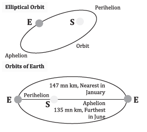
- Seasonal Variations: The Earth’s elliptical orbit means that the distance from the Sun changes throughout the year, affecting the intensity of insolation. During the perihelion, the Earth is closest to the Sun, and insolation is at its maximum; conversely, during the aphelion, the Earth is furthest, and insolation decreases.
- Implications: This variation contributes to seasonal changes, particularly evident in the contrast between summer and winter insolation levels.
2. Duration of Daily Sunlight Period
- Mechanism: The axial tilt of the Earth (approximately 23.5 degrees) results in varying lengths of day and night across different seasons. The tilt causes the Sun to be above the horizon for different lengths of time, depending on the latitude and the time of year.
- Latitude Effect: Polar regions experience extreme variations, from 24 hours of daylight in summer to complete darkness in winter, directly influencing the amount of solar radiation received.
- Seasonal Impact: The longer daylight hours in summer increase the duration of solar exposure, boosting insolation, while shorter days in winter reduce it.
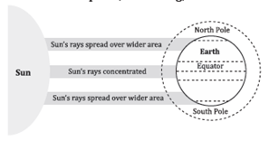
3. Angle of Incidence
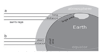
- Concept: The angle of incidence refers to the angle at which the Sun’s rays strike the Earth’s surface. This angle affects the concentration and intensity of solar radiation.
- Direct Incidence: Near the equator, the Sun’s rays can be nearly perpendicular to the surface, especially at the equinoxes. This direct incidence leads to high insolation intensity because solar energy is concentrated on a smaller surface area.
- Oblique Incidence: At higher latitudes, the Sun’s rays strike the Earth at more oblique angles, spreading the same amount of energy over a larger area, thereby reducing the intensity of insolation.
- Atmospheric Path: The obliquity of the rays also means they travel through more of the Earth’s atmosphere before reaching the surface, increasing the potential for scattering and absorption and further diminishing the solar energy available at the surface.
4. Local Environmental Factors
- Though not explicitly mentioned in the initial query, local environmental factors also significantly influence the amount of solar radiation received at a specific location:
- Topography: Mountainous regions can receive more solar radiation due to their elevation and the reduced atmosphere above, while valleys may receive less due to shadowing.
- Albedo: The reflectivity of a surface affects its ability to absorb or reflect solar radiation. Snow-covered areas reflect more solar energy, while darker surfaces, like forests or oceans, absorb more, affecting the local climate.
- Atmospheric Composition: The presence of clouds, dust, and pollutants can reflect, scatter, or absorb solar radiation, altering the amount that reaches the Earth’s surface.
Influence on the Path of Rays
Angle of Incidence and Atmospheric Path
- Angle of Incidence: Solar rays entering the Earth’s atmosphere at shallow angles, or small angles of incidence, must traverse a longer path through the atmosphere compared to rays that enter more directly (at steeper angles). This is particularly relevant during sunrise and sunset or at higher latitudes year-round.
- Atmospheric Absorption and Scattering: As solar rays pass through the atmosphere, they encounter gases, clouds, and particles that can absorb or scatter the radiation. The longer the path through the atmosphere, the greater the potential for these interactions, leading to a reduction in the intensity of solar radiation reaching the surface.
Transparency of the Atmosphere Towards Heat Radiation
Cloud Cover and Thickness
- Impact of Clouds: Thick cloud cover acts as a barrier to incoming solar radiation, reflecting a significant portion back into space and absorbing some. However, clouds can also trap heat, affecting local temperatures. The net effect on insolation depends on the type, altitude, and thickness of the cloud cover.
Dust Particles
- Aerosols and Dust: Particles in the atmosphere, including dust and industrial aerosols, can reflect sunlight back into space (albedo effect) or absorb solar energy. This reduces the amount of direct solar radiation reaching the Earth’s surface but can also contribute to warming of the atmosphere.
Water Vapor
- Absorption of Radiation: Water vapor in the atmosphere absorbs certain wavelengths of solar radiation, particularly in the infrared spectrum. This can reduce the direct insolation reaching the Earth’s surface but also plays a significant role in the greenhouse effect, trapping heat in the atmosphere.
Output of Solar Radiation
Variations in Solar Output
- Solar Constant: The amount of solar radiation received at the top of Earth’s atmosphere is approximately 1,366 watts per square meter, known as the solar constant. However, this value can vary slightly due to changes in solar activity and the Earth-Sun distance over the year.
- Solar Activity Cycles: The Sun goes through cycles of activity, typically every 11 years, which can affect the amount of solar energy emitted. These cycles can influence climate patterns and the amount of insolation received on Earth.
Aphelion and Perihelion
Elliptical Orbits
- Orbital Variations: Earth’s orbit around the Sun is not a perfect circle but an ellipse. This means the distance between the Earth and the Sun changes throughout the year, affecting the amount of solar radiation received.
- Aphelion and Perihelion Effects: At aphelion, the Earth is at its furthest point from the Sun, receiving slightly less solar energy. At perihelion, it is closest, receiving more solar energy. These variations are minor but contribute to seasonal changes in insolation, compounded by the tilt of the Earth’s axis.
| Perihelion | Aphelion |
| The point at which planets or comets are nearer to the Sun is called Perihelion. | The point at which planets or comets are furthest to the Sun is called Aphelion |
| For the Earth: It is a point where the Earth is closest to the Sun (91.4 million miles, or 147 million kilometres) | For the Earth: It is a point where the Earth is farthest to the Sun (94.5 million miles, or 152 million kilometres) |
| It occurs in January (between 2 to 6 January) | It occurs in July (around 4 July) |
| Next Perihelion will occur on January 4, 2024. | Next Aphelion will occur on July 4, 2023. |
Solar Variation
Solar variation refers to the changes in the amount of radiation received from the sun by the Earth, which can have various causes and effects. This concept is pivotal in understanding both the Earth’s climate system and the daily weather patterns.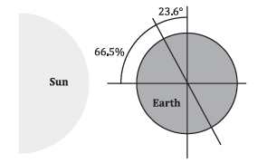 1. Variation in Solar Radiation
- Annual Variations Due to Earth’s Orbit: The Earth’s orbit around the sun is not a perfect circle but an ellipse. This means the distance between the Earth and the sun varies throughout the year, leading to slight variations in the amount of solar radiation (or insolation) received at the top of the Earth’s atmosphere. These variations are primarily marked by two positions:
- Aphelion: The point in the Earth’s orbit where it is farthest from the sun, typically occurring around July 4th. During aphelion, the Earth receives slightly less solar radiation.
- Perihelion: The point where the Earth is closest to the sun, usually around January 3rd. At perihelion, the Earth receives more solar radiation.
- Impact of Earth-Sun Distance on Insolation: Although the distance between the Earth and the sun varies, causing changes in insolation, this effect is relatively minor and does not significantly impact daily weather patterns on Earth. The variation in distance causes about a 3.4% change in Earth’s receipt of solar energy throughout the year. However, due to the Earth’s atmosphere and oceanic currents distributing heat around the planet, the impact on weather and climate is buffered.
2. Influencing Factors
- Distribution of Land and Sea: The Earth’s surface is unevenly distributed between land and water, which affects how solar radiation is absorbed and re-radiated back into the atmosphere. Water bodies have a higher heat capacity than land, meaning they can absorb more heat without a significant change in temperature. This difference influences weather patterns and can moderate the effects of solar variation.
- Atmospheric Circulation: The atmosphere plays a crucial role in distributing heat around the planet. Atmospheric circulation, including the movement of air masses and the formation of wind patterns, helps to disperse and redistribute the sun’s energy. This process further mitigates the direct impact of variations in solar radiation on weather and climate.
3. Variation Throughout Timescales
- Daily Variation: The amount and intensity of solar radiation vary throughout the day, with maximum insolation occurring at noon when the sun is highest in the sky.
- Seasonal Variation: Seasons are a result of the Earth’s tilt on its axis relative to its orbital plane around the sun. This tilt causes varying angles of solar radiation to strike different parts of the Earth at different times of the year, leading to seasonal changes in weather and climate.
- Annual Variation: Aside from the slight variation caused by the Earth’s elliptical orbit, solar output can also change due to the sun’s own cycles, such as the 11-year solar cycle, which can affect the amount of solar radiation reaching the Earth.
Factors that Causes these Variations in Insolation
1. Rotation of Earth on its Axis
- Axis Tilt: Earth’s axis is tilted at an angle of approximately 23.5° relative to the perpendicular to the plane of its orbit around the Sun. This tilt causes varying solar energy distribution across different latitudes throughout the year.
Impact on Insolation:
- Latitude Variation: The tilt of Earth’s axis results in different latitudes receiving varying amounts of sunlight during the year. This variation is most pronounced during the solstices when the tilt of Earth directly influences the duration of daylight.
- Day Length Variation: The length of day and night at any given latitude changes over the year, with significant variations noted at higher latitudes.
Daylight Duration on Solstices:
To illustrate, let’s consider the duration of daylight at various latitudes on the December and June solstices.
| Latitude | Dec 22 Daylight Duration | June 21 Daylight Duration |
| 0° | 12 hours, 00 minutes | 12 hours, 00 minutes |
| 20° | 10 hours, 48 minutes | 13 hours, 12 minutes |
| 40° | 9 hours, 08 minutes | 14 hours, 52 minutes |
| 60° | 5 hours, 33 minutes | 18 hours, 27 minutes |
| 90° | 0 hours, 00 minutes | 24 hours, 00 minutes* |
*Note: At the poles (90° latitude), there’s continuous daylight or darkness for about six months each, depending on the time of year.
2. Angle of Inclination of the Sun’s Rays
- Latitude Influence: The latitude of a place determines the angle at which the sun’s rays hit the Earth’s surface. At higher latitudes, the sun’s rays are more slanted when compared to the vertical rays that strike near the equator.
Impact on Insolation:
- Coverage and Intensity: Slanted rays cover a larger area but with less intensity compared to the concentrated, vertical rays at the equator. This dispersion results in lower energy received per unit area.
- Atmospheric Interaction: Slanted rays travel through more of Earth’s atmosphere, which increases absorption, scattering, and diffusion of solar energy before it reaches the surface. This further reduces the intensity of sunlight and, consequently, the amount of insolation received.
 Length of the Day
- Seasonal Variation: The Earth’s tilt and its orbit around the Sun lead to changes in the length of the day throughout the year. During summer in either hemisphere, days are longer, providing more time for the Earth to receive sunlight. Conversely, winter brings shorter days and less insolation.
- Impact on Insolation: There is a direct correlation between the length of the day and the amount of insolation received. Longer days in the summer months lead to an increase in insolation, contributing to warmer temperatures.
Transparency of the Atmosphere
- Influencing Factors: The atmosphere’s clarity is affected by aerosols (like smoke and soot), dust, water vapor, and cloud cover. These elements can absorb, reflect, or transmit solar radiation, altering the amount of insolation that reaches the Earth’s surface.
- Examples of Atmospheric Impact:
- Thick Clouds: Serve as barriers to solar radiation, significantly reducing the insolation that reaches the surface.
- Water Vapor: Absorbs solar radiation, thereby reducing the energy available at the Earth’s surface.
Configuration of Land
- Geographical Variation in Insolation: The amount of insolation received varies across different regions of the Earth, with tropical areas receiving about 320 watts per square meter and polar regions only about 70 watts per square meter.
- Influence of Geography:
- Subtropical Deserts: Receive maximum insolation due to clear skies and minimal cloudiness, enhancing solar radiation’s penetration to the surface.
- Land vs. Ocean: At the same latitude, land areas receive more insolation than oceans. This discrepancy is partly due to the higher reflectivity (albedo) of water bodies and the heat capacity of water, which absorbs and distributes heat more evenly than land.
Additional Insights
- Aspect of Land: The orientation or aspect of land can also affect insolation. Slopes facing the Sun (e.g., south-facing slopes in the Northern Hemisphere) receive more sunlight than those facing away.
- Altitude: Higher altitudes may receive more insolation due to thinner atmosphere, despite being cooler overall.
| Process | Description |
| Absorption | Solar insolation is absorbed by the components of the atmosphere such as dust particles, cloud cover, water vapour, etc. |
| Reflection | Components of the atmosphere such as dust particles, water droplets, gaseous material do not let solar radiation pass toward the earth’s surface, consequently, it’s turned back to space through dust particles. Therefore, insolation is decreased. |
| Diffusion | In this, insolation is reflected at multiple angles after striking with a surface. |
Heat Balance
The concept of the Heat Balance or Heat Budget of the Earth is a fundamental principle in understanding how the Earth’s climate system works. It revolves around the balance between the amount of solar energy received by the Earth from the Sun and the energy that the Earth radiates back into space. This balance ensures that the Earth’s temperature remains relatively stable over time, allowing life to thrive.
Understanding Heat Budget
The Earth’s heat budget is governed by the principle of energy conservation, which states that energy cannot be created or destroyed, only transformed from one form to another. In the context of the Earth’s climate system, this means that, over time, the amount of energy received from the Sun must equal the amount of energy radiated back into space for the Earth’s temperature to remain constant.
Components of the Heat Budget
- Incoming Solar Radiation (Insolation): The Earth receives energy from the Sun in the form of shortwave solar radiation. This energy is essential for heating the Earth’s surface and atmosphere, driving weather patterns, and supporting life.
- Absorption by the Earth’s Surface: A significant portion of the incoming solar radiation is absorbed by the Earth’s surface, warming the land, oceans, and atmosphere. The amount of absorbed energy varies with the surface’s albedo, or reflective capacity, where surfaces like snow and ice reflect more solar radiation than darker surfaces like forests or oceans.
- Reflection and Scattering: A portion of the incoming solar radiation is reflected back into space by the Earth’s atmosphere, clouds, and surface. The Earth’s albedo plays a crucial role in determining how much solar radiation is reflected without being absorbed.
- Outgoing Longwave Radiation: The Earth’s surface, after absorbing solar energy, emits it back into the atmosphere as longwave radiation, or infrared radiation. This process is critical for the Earth’s heat balance, as it allows the planet to radiate heat back into space.
- Greenhouse Effect: Greenhouse gases in the Earth’s atmosphere, such as carbon dioxide, methane, and water vapor, absorb some of the outgoing longwave radiation and re-radiate it back towards the Earth’s surface, warming the planet. This natural greenhouse effect is crucial for maintaining the Earth’s temperature at a level conducive to life.
The Balance
For the Earth to maintain a stable climate, the amount of energy received from the Sun must be equal to the amount of energy the Earth radiates back into space. This balance can be disrupted by natural phenomena, such as volcanic eruptions or variations in solar output, and human activities, especially the emission of greenhouse gases, which enhance the greenhouse effect and can lead to global warming.
The Role of the Atmosphere and Oceans
The atmosphere and oceans play critical roles in distributing heat around the planet. Atmospheric and oceanic circulations, such as winds, currents, and the water cycle, redistribute heat from the equator towards the poles, helping to moderate the Earth’s climate and making diverse habitats possible.
Heating and Cooling of the Atmosphere
The heating and cooling of Earth’s atmosphere are critical processes that determine the planet’s climate, weather patterns, and the overall energy balance. These processes are complex and influenced by a variety of factors including the Sun, the Earth’s surface (land and ocean), latitude, and the angle of incidence of the Sun’s rays. Understanding the mechanisms behind these processes is essential for climatology, the study of climate, atmospheric science, and environmental science.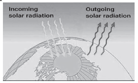 1. Radiation
Radiation is the primary way solar energy reaches Earth’s surface and the means by which Earth loses energy to outer space. This process involves the transfer of energy in the form of electromagnetic waves.
- Incoming Solar Radiation (Insolation): Earth receives sunlight in the form of shortwave radiation, which heats its surface. This is a direct heating process where the energy from the Sun is absorbed by the Earth’s surface, causing it to warm up.
- Terrestrial Radiation: Once the Earth’s surface is heated, it re-radiates energy back into the atmosphere in the form of longwave radiation. This indirect heating process warms the atmosphere from below. Greenhouse gases like carbon dioxide and water vapor absorb this longwave radiation, which helps to keep the atmosphere warm. This is a crucial aspect of the greenhouse effect, which is vital for maintaining Earth’s habitable climate.
2. Conduction
Conduction is the process of heat transfer through direct contact. In the context of the atmosphere:
- Heat Transfer to the Atmosphere: The Earth’s surface, after being warmed by insolation, transfers heat to the air in direct contact with it. This heat then gradually transfers to the air layers above, warming the lower atmosphere.
- Significance: Although conduction is less efficient compared to other methods of heat transfer in the atmosphere, it plays a crucial role in heating the lowermost layers of the atmosphere, especially near the Earth’s surface.
3. Convection
Convection refers to the vertical movement of heat within the troposphere, the lowest layer of Earth’s atmosphere.
- Vertical Heat Transfer: When the Earth’s surface heats the air above it, the warm air expands, becomes less dense, and rises in the form of convective currents. As it rises, it cools and eventually sinks back down, creating a cycle that helps distribute heat within the troposphere.
- Characteristics: Convection is limited to the troposphere and is slower compared to radiation. It requires a medium (in this case, air) for the transfer of heat and is a key process in the formation of various weather phenomena.
4. Advection
Advection involves the horizontal movement of heat across the Earth’s surface through the movement of air.
- Horizontal Heat Transfer: This process is significant for explaining the day-to-night variations in temperature, especially in mid-latitude regions where it plays a more prominent role than vertical heat transfer (convection).
- Impact on Local Weather: In tropical regions, advection is responsible for local winds and weather patterns. For example, the ‘loo’ in Northern India during summer is a result of advection, where hot, dry winds contribute to the region’s high temperatures.
Heat Budget of the Planet Earth
The heat budget of Planet Earth is a fundamental concept in understanding the Earth’s climate system and its ability to maintain a relatively stable average temperature over time. This balance is critical for sustaining life as it ensures that the planet does not progressively warm up or cool down significantly. The heat budget is described by the balance between incoming solar energy (insolation) and outgoing terrestrial radiation. Here’s a detailed breakdown of the heat budget:
Incoming Solar Energy (Insolation)
- Total Insolation Received at the Top of the Atmosphere: 100% of the solar energy that reaches Earth is measured at the top of the atmosphere before any interactions with the Earth’s surface or atmosphere.
Reflected Energy
- Total Reflected Back to Space: 35% of the total insolation is reflected back into space. This reflection occurs due to several factors:
- Clouds and Atmosphere: 27% of the incoming solar energy is reflected back by clouds and atmospheric particles.
- Snow and Ice-covered Areas: 2% is reflected by snow and ice due to their high albedo (reflectivity).
- Miscellaneous: 6% includes reflection from other surfaces and particles in the atmosphere.
Absorbed Energy
- Total Absorbed Energy: 65% of the incoming solar energy is absorbed by the Earth system (surface and atmosphere).
- Earth’s Surface: 51% of the total insolation is absorbed directly by the Earth’s surface, heating land, oceans, and contributing to the Earth’s overall temperature.
- Within the Atmosphere: 14% is absorbed by the atmosphere itself through gases, dust, and clouds.
Outgoing Terrestrial Radiation
- Radiated to Space Directly: 17% of the absorbed energy is emitted back into space directly from the Earth’s surface as terrestrial radiation.
- Absorbed by the Atmosphere: 34% of the terrestrial radiation is absorbed by the atmosphere, which is then involved in various processes:
- Direct Absorption: 6% is absorbed directly by atmospheric gases.
- Convection and Turbulence: 9% is transferred through convection and atmospheric turbulence.
- Latent Heat of Condensation: 19% is involved in the latent heat processes related to water vapor condensation.
Re-emitted Energy by Atmosphere
- Total Absorbed by the Atmosphere: 48% of the energy (from both insolation and terrestrial radiation) is absorbed by the atmosphere and later re-emitted.
- From Insolation: 14% of the direct solar energy absorption.
- From Terrestrial Radiation: 34% from the Earth’s surface radiation absorbed and then re-emitted by the atmosphere.
Balance Achieved
The balance is achieved when the total of 65% of the energy received from the sun is matched by the 65% of the energy returned back to space (17% directly and 48% through atmospheric absorption and re-emission). This balance ensures that the Earth neither warms up nor cools down significantly over time, maintaining a stable climate conducive for life.
| Category | Description | Percentage (%) |
| Insolation Received at the Top of the Atmosphere | Total solar energy received | 100% |
| Reflected Back to Space | Total energy reflected back into space | 35% |
| From Clouds and Atmosphere | Reflected by clouds and atmospheric particles | 27% |
| From Snow and Ice-covered Areas | Reflected by snow and ice surfaces | 2% |
| Miscellaneous Reflections | Reflected by other surfaces and particles | 6% |
| Absorbed Energy | Total energy absorbed by Earth and atmosphere | 65% |
| By Earth’s Surface | Absorbed directly by the Earth’s surface | 51% |
| Within the Atmosphere | Absorbed by atmospheric gases, dust, clouds | 14% |
| Terrestrial Radiation (Absorbed Energy – 51%) | Energy emitted back into space as heat | |
| Radiated to Space Directly | Directly emitted back into space | 17% |
| Absorbed by the Atmosphere | Energy absorbed by the atmosphere | 34% |
| Direct Absorption | Absorbed directly by atmospheric gases | 6% |
| Convection and Turbulence | Through air movements and turbulence | 9% |
| Latent Heat of Condensation | Through water vapor condensation | 19% |
| Atmospheric Absorption | Total energy absorbed by the atmosphere | 48% |
| From Insolation | Direct solar energy absorption | 14% |
| From Terrestrial Radiation | From Earth’s surface radiation | 34% |
| Total Radiation Returning to Space | Sum of energy emitted back into space | 65% |
Terminology Related to Heat Budget
The concept of a heat budget is crucial in understanding the Earth’s climate system and the mechanisms by which the planet maintains its average temperature. This balance involves various processes related to the absorption, reflection, scattering, and emission of solar radiation.
Insolation
Insolation stands for INcoming SOLar radiATION and refers to the sunlight that reaches the Earth. This solar radiation is critical for the Earth’s heat budget as it provides the primary source of energy that heats the planet. Insolation is subject to several processes upon entering the Earth’s atmosphere:
- Reflection: This process occurs when solar radiation hits a surface and bounces back into space without being absorbed or converted into heat. Reflective surfaces, such as ice, snow, and some clouds, have high albedo, meaning they reflect a significant portion of incoming solar radiation. Reflection plays a vital role in regulating the Earth’s temperature by preventing all the solar energy from being absorbed.
- Absorption: When solar radiation is absorbed, it is converted into heat energy. The Earth’s surface and atmosphere absorb a portion of the incoming solar radiation. This absorption is critical for warming the Earth and sustaining life. Different surfaces and materials have varying capacities for absorption; for example, dark surfaces like the ocean absorb more solar radiation than lighter surfaces.
- Scattering: Scattering occurs when solar radiation encounters small particles within the Earth’s atmosphere, such as air molecules, water droplets, or dust, causing the radiation to spread out in different directions. This process is responsible for the diffuse distribution of light in the atmosphere, leading to phenomena such as the blue color of the sky.
 Terrestrial Radiation
- Terrestrial radiation refers to the longwave radiation emitted by the Earth back into the atmosphere. This radiation is a result of the Earth absorbing solar radiation and then radiating the energy back into space as heat. The processes associated with terrestrial radiation in maintaining the Earth’s heat balance include:
- Latent Heat Transfer: This transfer occurs during the phase change of a substance, such as water evaporating into vapor or ice melting into water. Latent heat is either absorbed or released during these phase changes, which significantly influences the heat budget. For example, when water evaporates, it absorbs heat from its surroundings, effectively cooling the surface.
- Sensible Heat Transfer: Sensible heat refers to the transfer of energy that results in a temperature change of a substance without changing its phase. This type of heat transfer occurs when warmer air near the Earth’s surface rises and transfers heat to the cooler atmosphere above, or when the wind transfers heat from one area to another.
These processes are integral to the Earth’s heat budget, ensuring a balance between the energy received from the Sun and the energy emitted back into space. This delicate balance maintains the Earth’s average temperature, making it habitable for life. Understanding these processes is key to studying climate change, as alterations in the Earth’s heat budget can lead to significant shifts in climate patterns.
Twilight: The Transition Between Day and Night
Twilight is a natural phenomenon characterized by the diffused light present in the sky when the Sun is just below the horizon, either in the early morning before sunrise or in the evening after sunset. This period is not just a marker of day transitioning to night or vice versa; it is a complex interplay of atmospheric conditions, solar angles, and scattering processes that illuminate the Earth’s lower atmosphere and surface, providing a unique, soft light.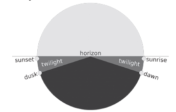
Understanding Twilight
Twilight occurs due to the scattering of sunlight by the Earth’s atmosphere. When the Sun is below the horizon, sunlight interacts with atmospheric molecules, water vapor, and dust particles. This interaction disperses the light, causing the upper atmosphere to glow and indirectly lighting the surface of the Earth. Factors like pollution, volcanic eruptions, and forest fires can enhance this effect by increasing the amount of particles in the atmosphere, leading to more pronounced twilight periods.
The term “twilight” not only refers to the phenomenon itself but also to the time periods during which this soft illumination is observable. These periods serve as a bridge between the darkness of night and the brightness of day, offering unique lighting conditions that have been valued across cultures and times for various activities.
The Phases of Twilight
Twilight is traditionally divided into three distinct phases, each marked by the Sun’s position below the horizon:
- Civil Twilight: Begins in the morning or ends in the evening when the Sun is 6 degrees below the horizon. It provides enough light for most outdoor activities without the need for artificial lighting.
- Nautical Twilight: Occurs when the Sun is between 6 and 12 degrees below the horizon. During this phase, the horizon is still visible at sea, aiding in navigation.
- Astronomical Twilight: When the Sun is between 12 and 18 degrees below the horizon. This phase is significant for astronomers, as the sky is dark enough for all astronomical observations to take place, except for the faintest objects.
Dawn and Dusk: The Bookends of Twilight
- Dawn: Marks the onset of morning twilight. It begins with astronomical twilight, progresses through nautical twilight, and ends with civil twilight, culminating in sunrise.
- Dusk: Signifies the beginning of evening twilight, starting with civil twilight, moving through nautical twilight, and ending with astronomical twilight, eventually leading to nightfall.
The Influence of Latitude
The duration and intensity of twilight phases are greatly influenced by the observer’s latitude. At the equator, where the Sun’s rays are almost perpendicular to the Earth, twilight phases are brief, typically lasting between 30 to 45 minutes. However, at higher latitudes, closer to the poles, the Sun’s angle of descent or ascent is shallower, resulting in prolonged periods of twilight. Near the poles, twilight can extend for weeks, leading to phenomena such as the “midnight sun” in summer and prolonged darkness in winter.
Atmospheric Phenomena During Twilight
Twilight is not just a time of day; it’s a canvas for atmospheric phenomena. The varying intensities of light and the angle of the Sun below the horizon contribute to a range of colors and effects in the sky. From the deep blues of astronomical twilight to the vibrant oranges and pinks of civil twilight, these moments are celebrated for their beauty and have inspired countless works of art and literature.
The dynamic nature of twilight, influenced by factors such as latitude, atmospheric conditions, and seasonal changes, makes it a subject of continuous fascination. This period of soft light offers not just practical benefits, such as extended working hours without the need for artificial lighting, but also moments of profound beauty that connect us to the rhythms of the Earth itself.
| Time | Position of Sun | Light Levels |
| Daylight | Above Horizon | — |
| Civil Twilight | Sunset to -6 degrees below horizon | Sky is bright, particularly in a western direction. A few of the brightest stars can be seen in the east. We can see clearly outdoors without artificial light. |
| Nautical Twilight | -6 degrees to -12 degrees below horizon | Sky is much darker. Artificial light is needed to see the outdoors clearly. All the brighter stars can be seen. |
| Astronomical Twilight | -12 degrees to -18 degrees below horizon | Sky is very dark, but brighter in a westerly direction. Hundreds of stars can be seen. |
| Darkness | More than -18 degrees below horizon | If away from light pollution, the sky appears black. Thousands of stars can be seen and the Milky Way is visible. |
Albedo: An In-Depth Exploration
Albedo is a critical concept in both climatology and astronomy, representing the measure of a surface’s ability to reflect sunlight. This reflective characteristic plays a significant role in determining the Earth’s climate as well as the physical properties of other celestial bodies.
Definition and Importance
- Albedo refers to the fraction of solar energy (shortwave radiation) reflected from the Earth back into space. It is a dimensionless measure, typically expressed as a percentage. Albedo influences the Earth’s energy balance and, consequently, its climate. Surfaces with high albedo, such as ice sheets and snow-covered areas, reflect a substantial portion of incoming solar radiation, while surfaces with low albedo, like forests and oceans, absorb more solar radiation, leading to warming.
Types of Albedo
Understanding albedo requires distinguishing between its two primary types:
- Terrestrial Albedo: This pertains to the Earth’s surface, encompassing various landscapes such as deserts, oceans, forests, and urban areas. The average terrestrial albedo of the Earth is approximately 0.31, meaning about 31% of incoming solar radiation is reflected back into space. This value varies significantly across different surfaces and is influenced by factors such as the angle of incoming solar radiation, surface texture, and the presence of vegetation or snow.
- Astronomical Albedo: This type measures the reflectivity of celestial bodies other than Earth, including planets, moons, asteroids, and comets. Astronomical albedo offers insights into the composition, surface properties, and atmospheric characteristics of these bodies. For instance, a high albedo could indicate a surface covered in ice or snow, while a low albedo might suggest a darker, rockier composition.
Factors Affecting Albedo
Several factors can influence the albedo of a surface or body, including:
- Surface Color: Light-colored surfaces have higher albedos than dark-colored surfaces.
- Texture: Rough surfaces can increase albedo by scattering light in different directions, enhancing reflectivity.
- State of Matter: Snow and ice, being solid forms of water, have higher albedos compared to liquid water.
- Angle of Incidence: The angle at which sunlight strikes a surface can affect its albedo; low angles can increase reflectivity due to a longer path through the atmosphere.
Implications for Climate Change
Albedo plays a critical role in the Earth’s climate system. Changes in albedo can result from natural processes, such as volcanic eruptions and seasonal snow cover variations, or human activities, including deforestation and urbanization. An understanding of albedo dynamics is essential for modeling climate change, as alterations in the Earth’s surface albedo can lead to significant climatic shifts. For example, melting ice caps reduce the Earth’s overall albedo, potentially accelerating global warming through a feedback loop where warming leads to more ice melt, further reducing albedo and causing additional warming.
Variation in the Net Heat Budget at the Earth’s Surface: Latitudinal Heat balance
Understanding the variation in the net heat budget at Earth’s surface, especially in terms of latitudinal heat balance, requires a deep dive into how solar radiation is distributed across the planet. This distribution affects climate, weather patterns, and the overall energy balance of the Earth.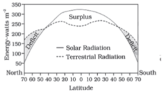 Solar Radiation and Earth’s Surface
- Solar Radiation: The Sun emits energy in the form of solar radiation, which reaches the Earth and is either absorbed or reflected. The amount of solar radiation received varies across different parts of the Earth’s surface, primarily due to the curvature of the Earth and its axial tilt.
- Absorption and Reflection: The Earth’s surface absorbs about 70% of the incoming solar radiation, with oceans, forests, and landmasses absorbing radiation at different rates. The remaining 30% is reflected back into space by clouds, ice, and other reflective surfaces.
Latitudinal Variation in Radiation Balance
1. Surplus and Deficit Zones:
- Surplus Zone: Between latitudes of 40°N and 40°S, the Earth experiences a surplus of net radiation balance. This is because these regions, especially the tropics, receive more direct sunlight throughout the year compared to higher latitudes.
- Deficit Zone: Regions near the poles, beyond 40°N and 40°S, are in a radiation deficit. These areas receive less solar radiation due to the low angle of sunlight and the high reflectivity of ice and snow (albedo effect).
2. Implications of the Radiation Balance:
-
- Tropics: The surplus in the tropics could lead to excessive heating if not for the redistribution of heat towards higher latitudes.
- Poles: Conversely, the polar regions would remain permanently frozen due to their radiation deficit if not for the influx of heat from lower latitudes.
Heat Redistribution Mechanisms
1. Atmospheric Circulation:
- Warm air rises in the tropics and moves towards the poles at high altitudes. As it cools, it descends and flows back towards the equator at lower altitudes. This circulation (e.g., Hadley, Ferrel, and Polar cells) helps distribute heat.
2. Oceanic Circulation:
-
- Ocean currents also play a crucial role in heat distribution. Warm currents such as the Gulf Stream transport heat from the equator towards the poles, while cold currents bring cooler water from the polar regions towards the equator.
Temperature
Temperature and heat are fundamental concepts in physics that describe different aspects of energy and its effects on matter. Although closely related, they represent distinct physical quantities that play crucial roles in the study of thermodynamics and kinetic theory.
Heat
- Definition: Heat is a form of energy that is transferred between substances or systems due to a temperature difference. It is often described as the total energy of molecular motion in a substance.
- Molecular Movement: The concept of heat is directly related to the kinetic energy of the particles (such as atoms or molecules) comprising a substance. The faster these particles move, the higher the amount of kinetic energy and, consequently, heat the substance contains.
- Transfer Mechanism: Heat can be transferred in three main ways: conduction (through direct contact), convection (through fluid movement), and radiation (through electromagnetic waves).
- Units: The standard unit of heat in the International System of Units (SI) is the joule (J). However, heat is also commonly measured in calories (cal) and British Thermal Units (BTU).
Temperature
- Definition: Temperature is a measure of the average kinetic energy of the particles in a substance. Unlike heat, temperature does not depend on the size or type of substance but rather on the average energy level of its particles.
- Coldness and Hotness: Temperature essentially measures how “hot” or “cold” an object is. It provides a scale to compare the energy levels of particles in different substances or systems.
- Thermodynamic Perspective: From a thermodynamic standpoint, temperature is a property that determines the direction of heat transfer between two systems. Heat flows spontaneously from a system with a higher temperature to one with a lower temperature until thermal equilibrium is reached.
- Units: The Celsius (°C), Fahrenheit (°F), and Kelvin (K) scales are the most commonly used temperature scales. The Kelvin scale is the SI base unit for temperature and is used in scientific contexts, where it starts at absolute zero, the theoretical point where particles have minimal kinetic energy.
 Factors Influencing Air Temperature
Several key factors influence the temperature of air at any given location, each playing a crucial role in the local climate and weather patterns.
1. Latitude
- Latitude is a primary determinant of a place’s temperature, as it affects the amount of solar radiation (insolation) a location receives. The Earth’s curvature causes varying angles of sunlight exposure, leading to significant temperature differences between regions at different latitudes. Equatorial regions receive direct sunlight year-round, resulting in higher temperatures, while polar regions, with more oblique sunlight, are cooler.
2. Altitude
-
- The altitude of a location has an inverse relationship with its temperature. This phenomenon is due to the manner in which the Earth’s atmosphere is heated: primarily through terrestrial radiation, which warms the air from the ground up. As a result:
- Temperature Decrease with Height: Temperature generally decreases with increasing elevation, a principle observed as one ascends from sea level to higher altitudes.
- Normal Lapse Rate: The rate at which temperature decreases with altitude is quantified as the normal lapse rate, approximately 6.5°C per 1,000 meters in the troposphere.
- The altitude of a location has an inverse relationship with its temperature. This phenomenon is due to the manner in which the Earth’s atmosphere is heated: primarily through terrestrial radiation, which warms the air from the ground up. As a result:
3. Distance from the Sea
- The proximity of a location to large bodies of water significantly impacts its temperature, primarily due to the water’s thermal properties:
-
-
-
-
- Moderating Effect: Water has a high specific heat capacity, meaning it heats and cools more slowly than land. This “moderating effect” leads to more stable temperatures in coastal regions compared to inland areas.
- Coastal areas tend to have milder temperatures than inland locations at similar latitudes. For instance, Jaisalmer, far from the sea, experiences more extreme temperatures than Mumbai, which is on the coast.
-
-
-
4. Prevailing Winds
-
- The characteristics of prevailing winds can alter local temperatures, depending on their origin:
- Warm Winds: Winds originating from warmer regions, such as the trade winds and westerlies in certain contexts, can raise temperatures by transporting heat.
- Cold Winds: Conversely, cold winds, like the polar easterlies, originate from cooler regions and can lower temperatures by bringing in cold air.
- The characteristics of prevailing winds can alter local temperatures, depending on their origin:
5. Mountain Barriers
-
- Mountain barriers play a significant role in influencing local climates by obstructing wind and air masses. This obstruction can lead to distinct weather patterns on either side of a mountain range.
- Example: The Himalayas block polar easterlies and blizzards, affecting temperature distribution such that the northern slopes are cooler, while the southern slopes are warmer. Similarly, the Alps act as a barrier in Europe, creating distinct climatic conditions on their flanks.
- Mountain barriers play a significant role in influencing local climates by obstructing wind and air masses. This obstruction can lead to distinct weather patterns on either side of a mountain range.
6. Cloudiness
-
- The presence or absence of clouds can significantly affect the temperature at the Earth’s surface by altering the amount of solar and terrestrial radiation that reaches or leaves the surface.
- Daytime Cloudiness: By blocking solar radiation, clouds can reduce daytime temperatures.
- Nighttime Cloudiness: Conversely, clouds at night act as an insulating layer, trapping heat and preventing excessive cooling.
- Clear Skies: Lead to greater temperature extremes, with higher temperatures during the day due to unobstructed sunlight and cooler temperatures at night as heat escapes into space.
- The presence or absence of clouds can significantly affect the temperature at the Earth’s surface by altering the amount of solar and terrestrial radiation that reaches or leaves the surface.
7. Nature of the Surface
-
- The temperature can also vary depending on the physical and chemical characteristics of the Earth’s surface.
- Albedo Effect: Surfaces with high reflectivity, like snow, reflect a significant portion of incoming solar radiation, leading to cooler temperatures. Conversely, darker surfaces, such as forests, absorb more heat, contributing to higher temperatures.
- The temperature can also vary depending on the physical and chemical characteristics of the Earth’s surface.
8. Moderating Effect of the Ocean
- Oceans moderate temperatures of nearby landmasses due to their thermal properties. Water heats and cools more slowly than land, leading to milder temperatures in coastal regions compared to inland areas.
9. Effect of Excess Landmass in the Northern Hemisphere
- The disproportionate distribution of land and sea affects temperature patterns, with the Northern Hemisphere experiencing more pronounced temperature variability due to its greater landmass.
10. Effect of Mountains on Temperature Distribution
- Beyond acting as barriers to air movement, mountains influence the horizontal distribution of temperature by blocking oceanic influences from penetrating inland, as seen with the Rockies and the Andes.
11. Continentality Effect
- Locations far from the ocean typically experience more significant temperature fluctuations, both daily and annually, due to the lack of the moderating influence of the ocean. This effect is most pronounced in the interiors of continents.
12. Air Masses and Ocean Currents
-
- Air Masses: The temperature of a region can be affected by the type of air mass overhead. Warm air masses bring higher temperatures, while cold air masses can lead to lower temperatures.
- Ocean Currents: Similarly, ocean currents play a critical role in regulating temperatures along coastlines. Warm currents, like the Gulf Stream, elevate temperatures in adjacent land areas, while cold currents, such as the Labrador Current, can lower temperatures and increase snowfall.
Global Temperature Distribution
To provide a comprehensive understanding of the global temperature distribution, we can break down the information into two main patterns: Horizontal Temperature Distribution and Vertical Temperature Distribution.
| Aspect | Horizontal Temperature Distribution | Vertical Temperature Distribution |
| Definition | Refers to the variation of temperature across the latitudes on the Earth’s surface. | Refers to the change in temperature relative to elevation or altitude, especially observed in the atmosphere. |
| Representation | Illustrated using ‘Isotherms’ on maps, which are lines connecting points of equal temperature. | Not typically shown with a specific map symbol but understood through temperature profiles of the atmosphere. |
| Primary Influence | Latitude, owing to the angle of the Sun’s rays hitting the Earth’s surface, which varies with latitude. | Elevation or altitude, with temperature generally decreasing as one moves higher above sea level. |
| Temperature Change | Temperature decreases from the equator towards the poles. | Temperature decreases with an increase in elevation, known as the normal lapse rate, which is approximately 6 °C per km in the Troposphere. |
| Factors Affecting | Factors include the distribution of land and water, ocean currents, and prevailing winds. | Besides elevation, factors like season, latitude, and other local factors (such as humidity and atmospheric conditions) can influence the temperature. |
| Variability | Varied by geographical features and seasonal changes but follows a general pattern of warmer temperatures near the equator. | The normal lapse rate is subject to variation due to height, season, latitude, and other local factors, making it not constant. |
| Significance | Helps in understanding climate zones, weather patterns, and the distribution of ecosystems across the globe. | Important for understanding weather phenomena, climate variation at different heights, and impacts on aviation and mountainous ecosystems. |
| Practical Applications | Used in climate modeling, predicting weather patterns, agriculture planning, and understanding biodiversity distribution. | Applied in aviation (for flight planning), mountaineering (to prepare for temperature changes with altitude), and studying the impact of elevation on climate and weather patterns in different regions of the world. |
This table encapsulates the fundamental differences and characteristics of horizontal and vertical temperature distributions, offering insights into how temperature varies across the Earth’s surface and with elevation, alongside the factors influencing these patterns and their implications.
Seasonal Temperature Distribution –January and July
| Feature | Northern Hemisphere | Southern Hemisphere |
| Effect of Landmass and Ocean Current | More pronounced due to larger land surface area. | Less pronounced effect of landmass due to smaller land area; ocean effects are more significant. |
| Ocean’s Influence | Less significant compared to the Southern Hemisphere due to larger land area. | More pronounced due to larger ocean surface area, leading to a more moderated climate. |
| Isotherms Behavior | Isotherms are less parallel to latitudes due to varied geography, resulting in abrupt temperature variations. | Isotherms are more or less parallel to the latitudes, leading to more gradual temperature variation across different latitudes. |
These variations are influenced by the differential heating of the Earth’s surface, the distribution of land and oceans, and prevailing ocean currents.
| Aspect | January | July |
| Isotherm Deviation | Isotherms deviate poleward over the ocean and equatorward over the continent. | Isotherms generally run parallel to latitude, with less deviation compared to January. |
| Poleward Shift on Oceans | Demonstrates that oceans/land are warmer, carrying high temperatures poleward. This effect is pronounced in the North Atlantic Ocean, influenced by the Gulf Stream and North Atlantic Drift. | The poleward shift is less pronounced due to the overall warmer global temperatures and reduced contrast between land and ocean temperatures. |
| Equatorward Bend on Continents | Indicates overcooling of continents, allowing polar cold winds to penetrate southwards, as seen in the Siberian plain. | Such bending is less noticeable. The land, especially in the subtropical continental regions of Asia, experiences temperatures over 30°C. |
| Temperature Records | – | Equatorial oceans record warmer temperatures, more than 27°C. |
| Seasonal Contrast | The deviation of isotherms is more pronounced, reflecting the stark temperature contrasts between land and ocean. | It is summer in the Northern Hemisphere and winter in the Southern Hemisphere, leading to opposite isothermal behavior compared to January. |
Temperature Anomaly
Temperature anomaly is a critical concept in climatology and meteorology, providing a nuanced understanding of local and global temperature variations. It’s essential for tracking climate change, understanding weather patterns, and making environmental policy decisions.
Definition of Temperature Anomaly
A temperature anomaly refers to the deviation of the mean temperature at a specific location from the mean temperature expected based on its latitude. This concept is vital for identifying how temperature patterns differ from the norm due to various geographical and meteorological factors.
Types of Temperature Anomalies
- Negative Anomaly: Occurs when the local temperature is lower than the average temperature expected for its latitude. This might indicate unusual cooling influences in the area, such as increased albedo or cold ocean currents.
- Positive Anomaly: Occurs when the local temperature is higher than the average temperature for its latitude, suggesting unusual warming influences, such as urban heat islands, warm ocean currents, or decreased albedo.
Causes of Temperature Anomalies
Temperature anomalies arise due to a combination of factors, including:
- Land and Water Contrasts: Land heats up and cools down faster than water, leading to significant temperature variations between coastal and inland areas.
- Prevailing Winds: Wind patterns can transport warm or cold air masses, affecting local temperatures.
- Ocean Currents: Currents can significantly influence local climates by transporting warm or cold water across the globe.
Importance and Use of Temperature Anomaly
Temperature anomalies are preferred over absolute temperature measurements for several reasons:
- Accuracy and Precision: Obtaining accurate absolute temperature estimates is challenging due to the uneven distribution of measurement stations and the need for significant interpolation in areas with sparse data. Anomalies, calculated from local reference values, reduce these uncertainties.
- Climate Change Indicators: Anomalies effectively indicate changes in temperature over time, reflecting broader climate trends. They help scientists understand how the climate is changing on a global scale, which is not as apparent when looking at absolute temperatures.
Application in Climate Science
Temperature anomalies are a cornerstone in the study of climate change. They provide a clear indication of how much the Earth’s climate deviates from what is considered “normal,” allowing scientists to track warming trends, investigate the effects of climate phenomena like El Niño and La Niña, and predict future climate patterns.
Heat Zones on The Earth
The Earth’s surface is divided into three primary heat zones, each characterized by distinct climatic conditions. These zones are determined by the Earth’s tilt and its orbit around the Sun, which affect the intensity and distribution of solar radiation.
1. Torrid Zone
Geographical Boundaries
- Location: Between the Tropic of Cancer (23.5°N latitude) and the Tropic of Capricorn (23.5°S latitude).
- Characteristics: This zone receives the highest amount of sunlight throughout the year because the sun’s rays fall most directly on this area.
Climatic Features
- Temperature: Generally high throughout the year, with minimal seasonal variation.
- Sunlight: Abundant sunlight leads to high evaporation rates, contributing to humid conditions in many regions within this zone.
- Precipitation: Varies widely, from the heavy rainfall of tropical rainforests to the arid conditions of subtropical deserts.
2. Temperate Zone
Geographical Boundaries
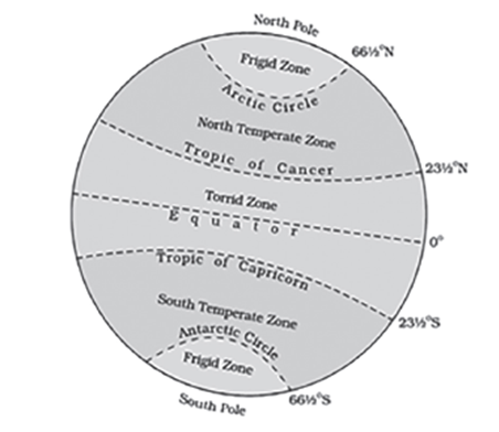
- Northern Hemisphere: Between the Tropic of Cancer and the Arctic Circle (66.5°N latitude).
- Southern Hemisphere: Between the Tropic of Capricorn and the Antarctic Circle (66.5°S latitude).
Climatic Features
- Temperature: Experiences moderate climate with distinct seasons due to the oblique angle of the sun’s rays.
- Sunlight: Receives less direct sunlight compared to the Torrid Zone, leading to cooler temperatures.
- Seasons: Marked seasonal changes, with warm summers and cool winters. The extent of these seasons can vary based on proximity to the poles or the equator.
Seasonal Temperature Distribution –
January and July
Northern Hemisphere
- Landmass and Ocean Currents: The Northern Hemisphere has a significant effect from landmass and ocean currents due to its larger land surface area compared to the Southern Hemisphere. This results in more pronounced seasonal temperature variations.
- Isotherms Behavior: Isotherms (lines of equal temperature) tend to deviate poleward over the oceans and equatorward over continents in January, indicating land cooling and ocean warming effects.
Southern Hemisphere
- Ocean Influence: The ocean’s effect is more pronounced here, leading to a more gradual temperature variation. The Southern Hemisphere’s extensive ocean coverage moderates temperature fluctuations.
Isotherms Deviation
- January: Isotherms deviate poleward over oceans (indicating warmer conditions) and equatorward over continents (indicating cooler conditions), especially pronounced in the North Atlantic due to warm currents like the Gulf Stream.
- July: Isotherms generally run parallel to latitudes, with warmer temperatures recorded over equatorial oceans and subtropical continental regions.
3. Frigid Zone
Geographical Boundaries
- Northern Hemisphere: Between the Arctic Circle and the North Pole.
- Southern Hemisphere: Between the Antarctic Circle and the South Pole.
Climatic Features
- Temperature: Characterized by very cold temperatures throughout the year due to the slanting sunbeams that reach these areas.
- Sunlight: During the summer months, these zones can experience continuous daylight for up to 24 hours a day, a phenomenon known as the Midnight Sun.
- Seasons: Very short summers lasting about 2 to 3 months, with long, harsh winters.
Atmospheric pressure
Atmospheric pressure is a fundamental concept in meteorology and environmental science, describing the force exerted by air molecules on a surface. This force is due to the weight of air molecules above a given point on Earth’s surface. Understanding atmospheric pressure is crucial for predicting weather patterns, studying climate change, and explaining various natural phenomena.
Definition and Measurement
- Atmospheric Pressure: It is the force per unit area exerted against a surface by the weight of air molecules above that surface. Essentially, it is the weight of the air.
- Units of Measurement: Atmospheric pressure is commonly measured in millibars (mb), with the average atmospheric pressure at sea level being 1013.2 mb. Other units include pascals (Pa), torr, and inches of mercury (inHg).
Distribution of Atmospheric Pressure
- Variability: Atmospheric pressure is not uniform across the Earth’s surface. It varies from one location to another and changes over time.
- Factors Influencing Pressure: The amount of atmospheric pressure at a given point depends on the number of air molecules above that point and their weight, which can be influenced by temperature, altitude, and the presence of water vapor.
Relationship Between Altitude and Pressure
- Altitude: As altitude increases, atmospheric pressure decreases. This inverse relationship is due to the decreasing density of air molecules at higher altitudes.
- Temperature: Temperature and atmospheric pressure are inversely related. When the air temperature increases, air expands, leading to a decrease in the number of molecules over a unit area, and thus, a reduction in pressure.
Mechanisms and Implications
- Air Movement: Variations in atmospheric pressure at different places and altitudes cause air to move horizontally from high-pressure areas to low-pressure areas, creating wind.
- Weather Patterns: Understanding atmospheric pressure variations is essential for predicting weather patterns, including storm systems, wind patterns, and precipitation.
Measurement Instruments
- Barometer: A device used to measure atmospheric pressure. There are two main types of barometers:
- Mercury Barometer: Consists of a glass tube filled with mercury in which the height of the mercury column changes as the atmospheric pressure changes.
- Aneroid Barometer: Uses a small, flexible metal box called an aneroid cell. Changes in atmospheric pressure cause the box to expand or contract, which is measured by the device.
Vertical Distribution of Atmospheric Pressure
Overview
Atmospheric pressure is the force per unit area exerted against a surface by the weight of the air above that surface in the atmosphere of Earth. This pressure decreases with increasing altitude due to the decreasing mass of air above any point. Understanding the vertical distribution of atmospheric pressure is crucial for various fields, including meteorology, aviation, and environmental science.
Relationship Between Altitude and Atmospheric Pressure
- At Sea Level: Atmospheric pressure is highest at sea level. This is because the entire mass of the atmosphere above this point contributes to the pressure exerted on the surface. Standard atmospheric pressure at sea level is defined as 1013.25 millibars (mb) or 760 millimeters of mercury (mmHg).
- Decrease with Altitude: As altitude increases, atmospheric pressure decreases. This is because the higher up you go, the less air there is above you to exert pressure. The decrease is most rapid nearest the Earth’s surface, where the air is denser and more compressed.
- Upper Atmosphere: In the upper atmosphere, the air is much thinner and less dense. Here, the decrease in pressure with altitude continues but at a slower rate compared to near the Earth’s surface.
Implications for Humans
- Breathing Difficulties: At higher altitudes, the reduced atmospheric pressure causes the air to be thinner, meaning there is less oxygen available for breathing. This can lead to discomfort, breathing difficulties, and altitude sickness for people who travel from lower to higher altitudes without adequate acclimatization.
Horizontal Distribution of the Atmospheric Pressure
Overview
The horizontal distribution of atmospheric pressure across the Earth’s surface varies primarily due to the uneven heating of the atmosphere by the sun. These variations in pressure are fundamental in determining wind patterns and weather conditions.
Factors Influencing Horizontal Pressure Distribution
- Heating and Cooling of Air: When air is heated by the sun, it expands, becomes lighter, and rises, creating areas of low pressure (low-pressure systems). Conversely, when air cools, it becomes denser and heavier, sinking towards the Earth’s surface, creating areas of high pressure (high-pressure systems).
- Formation of Pressure Systems:
- Low-Pressure Systems: Formed in areas where air is rising. These systems are often associated with cloudy and rainy weather because the rising air cools and condenses into clouds and precipitation.
- High-Pressure Systems: Formed in areas where air is sinking. These systems are typically associated with clear and sunny weather because the sinking air warms and inhibits cloud formation.
Effects on Weather
- Weather Patterns: The movement of high and low-pressure systems across the Earth’s surface drives the general circulation of the atmosphere, influencing weather patterns. For example, areas of low pressure draw in air from surrounding areas, potentially leading to wind and precipitation.
- Temperature Variations: The horizontal distribution of atmospheric pressure also affects temperature patterns. For instance, high-pressure systems can lead to warmer, drier conditions, while low-pressure systems may bring cooler, wetter weather.
Understanding the vertical and horizontal distribution of atmospheric pressure is essential for predicting weather patterns, designing buildings and aircraft to withstand various pressures, and preparing for the physiological effects of high altitudes on the human body.
Variation of Pressure
| Aspect | Horizontal Variation of Pressure | Vertical Variation of Pressure |
| Definition | Refers to the differences in atmospheric pressure across the Earth’s surface. | Refers to the changes in atmospheric pressure with altitude, from the Earth’s surface upwards. |
| Primary Causes | Differential heating of the Earth’s surface due to insolation.
Differences in air volume heating and cooling. |
Decrease in air density with altitude.
Thinning of the atmosphere as altitude increases. |
| Impact on Weather | Influences wind direction and speed. Affects weather patterns and climatic conditions. | Affects climatic conditions at different altitudes. Influences mountain weather and the distribution of biomes based on elevation. |
| Other Influencing Factors | Frictional force: Affects the wind’s speed and direction near the surface.
Coriolis force: Influences the wind direction due to Earth’s rotation. |
Temperature: Warmer air can hold more moisture, affecting pressure.
Local topography: Mountains and valleys can alter wind patterns and pressure. Proximity to the sea: Affects local climate and pressure variations. |
| Measurement and Analysis | Utilizes isobars (lines joining places of equal pressure) for mapping and analysis at constant levels. | Noted for its average decrease of about 1 mb (millibar) per 10 meters increase in height, although this can vary based on other factors. |
| Interesting Observations | Despite significant horizontal pressure differences, the primary wind flows are from high-pressure to low-pressure areas, modified by Earth’s rotation and surface friction. | Despite the strong vertical pressure gradient, vertical wind movement (updrafts) is relatively weak due to gravitational forces balancing the pressure differences. |
| Practical Implications | Essential for predicting weather patterns and designing structures to withstand local wind conditions. | Important for aviation: Pilots need to adjust to changing pressure for altitude control. Influences the design of buildings and structures in mountainous areas. |
General circulation of the atmosphere
The general circulation of the atmosphere is a fundamental concept in meteorology and climatology, illustrating the large-scale movement of air around the Earth. This movement is driven by the uneven heating of the Earth’s surface, which creates zones of high and low pressure, leading to the flow of air from areas of high pressure to areas of low pressure. The patterns formed by these flows are crucial for understanding weather patterns, climate zones, and the distribution of precipitation across the globe.
Atmospheric Pressure Variations
Atmospheric pressure variations are primarily caused by the differential heating and cooling of the Earth’s surface. When air is heated, it expands and becomes less dense, leading to lower pressure. Conversely, when air is cooled, it contracts and becomes denser, resulting in higher pressure. These variations in pressure are fundamental to the movement of air and the formation of wind patterns. The movement of air from high-pressure areas to low-pressure areas is a key driver in setting the atmosphere in motion, creating the winds and weather patterns we experience.
General Circulation of the Atmosphere
The term “general circulation” refers to the large-scale movement of air that helps distribute thermal energy (heat) from the equator towards the poles. This circulation involves complex interactions between the Earth’s rotation, the distribution of continents and oceans, and atmospheric pressure gradients. The patterns formed by these movements, such as the trade winds, westerlies, and polar easterlies, are stable features of the Earth’s atmosphere.
Planetary Winds
Planetary winds are a critical component of the general circulation. These winds flow consistently throughout the year along latitudinal lines, driven by latitudinal differences in air pressure. Examples of planetary winds include:
- Trade Winds: Found in the tropics, these winds blow from the subtropical high-pressure belts towards the equatorial low-pressure zone. They are easterly winds, meaning they move from the east to the west.
- Westerlies: Dominant in the mid-latitudes, these winds move from the subtropical high-pressure zones towards the polar regions. They flow from the west to the east, hence their name.
- Polar Easterlies: These are cold, dry winds blowing from the high-pressure areas of the polar highs towards the low-pressure areas in the polar fronts.
Categories of Atmospheric Circulation
Atmospheric circulation can be categorized into three main types based on scale and impact:
- Primary Circulation: This includes the general, worldwide patterns of wind and atmospheric movement. An example is the westerly winds, which dominate the mid-latitude regions such as North America and Europe. These global wind patterns are relatively stable and persistent over time.
- Secondary Circulation: These are regional circulation patterns that can vary seasonally. A well-known example is the monsoons, especially significant in South and Southeast Asia. Monsoons are characterized by a seasonal reversal of wind direction, bringing wet and dry seasons to the regions they affect.
- Tertiary Circulation: This category includes local winds influenced by the specific geography of an area, such as mountains, valleys, or coastlines. Examples include anabatic (uphill) and katabatic (downhill) winds, which are driven by local temperature differences. These winds have a significant impact on local weather conditions but are limited in geographic scope.
Understanding the general circulation of the atmosphere is crucial for predicting weather, understanding climate patterns, and even for planning activities that depend on specific wind patterns, such as aviation and sailing. This complex system reflects the dynamic and interconnected nature of Earth’s climate system, highlighting the importance of atmospheric sciences in our daily lives and the global ecosystem.
Emergence of Pressure Belts
The emergence of pressure belts around the Earth is a complex phenomenon influenced by various factors that affect atmospheric pressure. These factors interplay to create areas of high and low pressure, which are crucial for understanding global weather patterns and climate.
1. Temperature
Temperature plays a pivotal role in the behavior of atmospheric pressure. It is inversely proportional to pressure, meaning as temperature increases, pressure decreases and vice versa. This relationship is due to the properties of air molecules:
- Increase in Temperature: When the temperature rises, air molecules gain energy and move more vigorously, causing air to expand and become less dense. As a result, the air rises, leading to a decrease in pressure at the surface. This process is a key driver in the formation of low-pressure areas, particularly in regions near the Equator where sunlight is more direct and intense throughout the year.
- Decrease in Temperature: Conversely, a drop in temperature causes air molecules to lose energy, making the air denser and heavier. This denser air sinks, leading to an increase in pressure at the surface. High-pressure areas are often found in regions with lower temperatures, such as the polar regions.
2. Altitude
Atmospheric pressure is also affected by altitude due to the density of air molecules:
- Increase in Altitude: As altitude increases, the air becomes thinner because air molecules are more spread out. This leads to a decrease in atmospheric pressure. Mountainous regions and high-altitude areas experience lower pressure compared to sea level.
- Decrease in Altitude: At lower altitudes, the air is denser because air molecules are compressed closer together, resulting in higher atmospheric pressure. This is why pressure is higher at sea level and decreases with elevation.
3. Water Vapor
The presence of water vapor in the air significantly influences atmospheric pressure:
- Lighter than Air: Water vapor has a molecular weight of 18g/mol, which is lighter than the average molecular weight of dry air (29g/mol). Therefore, moist air (air containing water vapor) is lighter and less dense than dry air.
- Impact on Pressure: Since moist air is lighter, it rises, leading to a reduction in atmospheric pressure in areas with high humidity. This is why tropical regions, where evaporation rates are high, often have lower pressure compared to arid regions.
4. Gravitational Pull
The Earth’s gravity affects atmospheric pressure by holding the atmosphere close to the surface:
- Variation with Distance: The strength of gravitational pull decreases with distance from the Earth’s core. This means that atmospheric pressure is highest at the surface and decreases with altitude, as gravity’s ability to ‘pull’ air molecules towards the Earth weakens.
5. Earth’s Rotation
The rotation of the Earth influences atmospheric pressure through the Coriolis effect:
- Movement of Air: Earth’s rotation causes moving air to be deflected to the right in the Northern Hemisphere and to the left in the Southern Hemisphere. This deflection affects wind patterns and the distribution of high and low-pressure areas.
- Polar and Equatorial Differences: The rotation of the Earth also contributes to the difference in atmospheric pressure between the poles and the equator. Centrifugal force caused by Earth’s rotation is stronger at the Equator than at the poles, contributing to the accumulation of air mass and higher pressure at higher latitudes.
These factors collectively influence the formation and distribution of global pressure belts, which are essential for driving the Earth’s weather systems and climate patterns. Understanding these relationships helps meteorologists predict weather and climate changes, and provides insight into the dynamics of the Earth’s atmosphere.
Factors Affecting the Velocity and Direction of Wind
The velocity and direction of wind are influenced by a complex interplay of forces, each contributing to the overall behavior of wind patterns across the globe. Understanding these forces is crucial for meteorology, navigation, and environmental science.
1. Coriolis Force
- Nature of the Force: The Coriolis force is an apparent force resulting from the Earth’s rotation. It does not act directly on objects but affects their trajectory over the Earth’s surface.
- Effect on Wind Direction: This force causes moving air (wind) to be deflected to the right in the Northern Hemisphere and to the left in the Southern Hemisphere. This deflection influences the direction of wind flow, creating curved paths instead of straight lines.
- Relation to Latitude: The Coriolis force varies with latitude; it is maximum at the poles (90° latitude) and is zero at the Equator (0° latitude). This variation affects the degree of wind deflection, with more pronounced effects at higher latitudes.
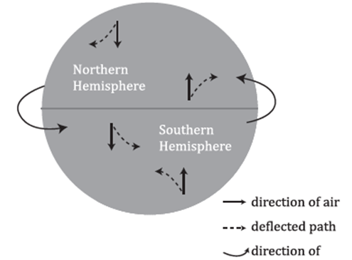
2. Pressure Gradient Force
- Definition: The pressure gradient force arises from differences in atmospheric pressure across different areas. It acts from high-pressure areas to low-pressure areas, driving wind movement.
- Influence on Wind Velocity: The strength of the pressure gradient force is determined by the pressure difference and the distance over which the pressure changes (gradient). Steep gradients, where isobars (lines of equal pressure) are close together, result in stronger forces and hence faster winds.
3. Frictional Force
- Impact at the Surface: Frictional force acts against the movement of wind, slowing it down. It is most significant near the Earth’s surface where obstacles like buildings, trees, and topography increase friction.
- Altitude Variation: The influence of friction decreases with altitude, becoming negligible above 1-3 km. At higher elevations, wind speeds increase as the frictional drag diminishes.
- Surface Differences: Frictional force varies with the nature of the Earth’s surface. It is lower over smooth surfaces like water and higher over rough, uneven land.
4. Centripetal Force
- Role in Circular Motion: Centripetal force is necessary for any object in circular motion, including air moving around a pressure system. It acts perpendicular to the direction of wind flow, pulling it inward towards the center of rotation.
- Effect on Wind Paths: This inward force allows wind to follow curved paths around high and low-pressure areas, rather than moving in straight lines. In meteorology, this contributes to the formation of cyclones and anticyclones, where wind circulates around a central point.
Combined Influence on Wind Patterns
The interplay between these forces determines the wind’s speed and direction. For instance, the pressure gradient force initiates wind movement from high to low-pressure areas, while the Coriolis force bends this movement due to the Earth’s rotation. Frictional force slows the wind, especially near the surface, and centripetal force guides winds in a curved path around pressure centers.
These dynamics are fundamental to understanding weather patterns, climate systems, and the general circulation of the Earth’s atmosphere. They explain phenomena such as trade winds, jet streams, and monsoons, which are critical to global climate and weather forecasting.
Pressure and Wind
Understanding Wind Generation
Wind is a dynamic atmospheric phenomenon resulting from the interplay of various forces. The primary factors influencing the direction and velocity of wind include:
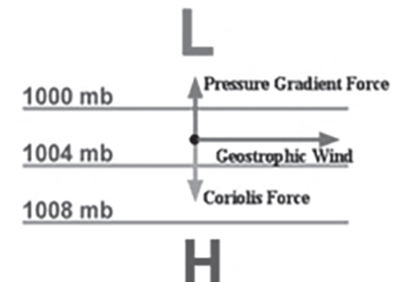
- Pressure Gradient Force: This is the force arising from the difference in atmospheric pressure across space. Air naturally moves from areas of high pressure to areas of low pressure, and the magnitude of this force depends on the pressure difference; the greater the difference, the stronger the force.
- Coriolis Force: A result of the Earth’s rotation, the Coriolis force deflects the path of moving air. In the Northern Hemisphere, this deflection is to the right, while in the Southern Hemisphere, it’s to the left. This force is crucial in shaping the wind’s direction but does not affect its speed.
Characteristics of Upper Atmosphere Wind
In the upper atmosphere, approximately 2 to 3 kilometers above the Earth’s surface, wind behavior is notably distinct due to the absence of surface friction. Here, the wind is primarily governed by:
- Pressure Gradient: Dictates the initial motion of air from high to low-pressure areas.
- Coriolis Force: Alters the wind’s direction to maintain a balance with the pressure gradient force.
This interaction leads to the formation of Geostrophic Wind, which flows parallel to isobars (lines of equal pressure) when isobars are straight, and the forces of pressure gradient and Coriolis are in equilibrium. Geostrophic wind is significant in the free atmosphere where friction is negligible.
Wind Circulation Patterns
Cyclonic and Anticyclonic Circulation
The behavior of wind around low and high-pressure systems varies significantly between the Northern and Southern Hemispheres due to the Coriolis effect.

- Cyclonic Circulation (Low Pressure): Characterized by the convergence of air towards the center of a low-pressure system. As air converges, it is forced upwards, leading to cloud formation and potentially precipitation. The rotation of the wind is counterclockwise in the Northern Hemisphere and clockwise in the Southern Hemisphere due to the Coriolis force.
- Anticyclonic Circulation (High Pressure): In contrast, high-pressure systems are marked by the divergence of air at the surface. Air subsides from above, leading to clearer skies as cloud formation is inhibited. The rotation direction is clockwise in the Northern Hemisphere and counterclockwise in the Southern Hemisphere.
Factors Affecting Wind Circulation
- Location in the Hemisphere: The hemisphere (Northern or Southern) determines the direction of the Coriolis force and, subsequently, the wind’s rotation around pressure systems.
- Presence of Friction: Near the Earth’s surface, friction reduces wind speed and alters its direction. This deviation from the geostrophic balance introduces a cross-isobaric component, leading to air spiraling out of high-pressure systems and into low-pressure systems.
Pattern of Planetary Winds Depends Upon
The pattern of planetary winds is a complex system influenced by various factors, including latitudinal variation in atmospheric heating, the emergence of pressure belts, the migration of these pressure belts with the sun’s apparent path, the distribution of continents and oceans, the Earth’s rotation, and centripetal force. Each of these factors plays a crucial role in determining the speed, direction, and nature of the winds that circulate around our planet. Let’s explore each factor in more detail to understand how they contribute to the global wind patterns:
Latitudinal Variation of Atmospheric Heating
- Concept: The Earth’s surface does not heat evenly because of its curvature and the tilt of its axis. This differential heating creates areas of high and low atmospheric pressure, significantly impacting wind speed and direction.
- Example: The equatorial region receives more direct sunlight throughout the year, leading to significant heating of the air. This warm air expands and rises, creating a zone of low pressure known as the equatorial low. Conversely, the poles receive less direct sunlight, resulting in colder, denser air that sinks, forming high-pressure zones.
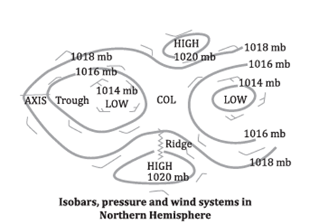
Emergence of Pressure Belts
- Concept: The Earth’s atmosphere is organized into distinct pressure belts that circle the planet. These belts include the equatorial low-pressure belt, the subtropical high-pressure belts, the subpolar low-pressure belts, and the polar high-pressure belts.
- Impact: The interaction between these pressure belts generates major planetary wind systems, such as the Trade Winds, Westerlies, and Polar Easterlies. These winds are crucial for global climate patterns and weather systems.
Migration of Pressure Belts Following the Apparent Path of the Sun
- Concept: As the Earth orbits the sun, the tilt of its axis causes the sun’s direct rays to shift between the Tropic of Cancer and the Tropic of Capricorn. This movement causes the pressure belts and the intertropical convergence zone (ITCZ) to shift latitudinally with the seasons.
- Effect: This shifting of pressure belts causes seasonal changes in wind patterns, affecting weather conditions globally, such as the monsoons in South Asia.
Distribution of Continents and Oceans
- Concept: The distribution of land and sea affects the temperature and pressure differences on the Earth’s surface, influencing wind patterns.
- Observation: The Southern Hemisphere, with its vast oceans, experiences more stable and pronounced wind patterns compared to the Northern Hemisphere, where large landmasses lead to greater temperature and pressure variations.
Rotation of the Earth
- Concept: The Earth’s rotation on its axis generates the Coriolis force, which acts perpendicular to the direction of wind flow and deflects winds to the right in the Northern Hemisphere and to the left in the Southern Hemisphere.
- Outcome: This deflection creates the characteristic curved paths of winds and ocean currents, leading to the formation of the Trade Winds, Westerlies, and Polar Easterlies.
Centripetal Force
- Concept: In the context of planetary winds, centripetal force refers to the inward force that is necessary to keep an object moving in a circular path. It affects wind patterns around high and low-pressure systems.
- Application: In high-pressure systems, winds move outward and are deflected by the Coriolis force, creating anticyclonic flow. In low-pressure systems, winds move inward and are deflected, creating cyclonic flow. This force is crucial in the formation and movement of weather systems around the globe.
Understanding these factors in unison helps us appreciate the complexity and dynamism of Earth’s climate system. The interplay between atmospheric heating, pressure belts, Earth’s rotation, and other factors creates a constantly changing pattern of winds that transport heat, moisture, and pollutants around the globe, shaping our weather and climate patterns.
Distribution of Pressure Belts
The distribution of pressure belts across the Earth’s surface plays a critical role in determining global climate patterns, including wind circulation, precipitation, and temperature variations. These pressure belts are essentially regions where air pressure is consistently higher or lower than surrounding areas.
Equatorial Low Pressure Belt
Location and Extent
- The Equatorial Low Pressure Belt, also known as the Doldrums or the Inter Tropical Convergence Zone (ITCZ), stretches approximately from 0° to 10° latitude both North and South of the Equator. This geographical positioning places it directly under the most consistent solar heating throughout the year.
Formation and Characteristics
- Thermal Development: This belt is thermally induced, meaning it forms due to the intense solar heating near the Equator. The sun’s rays strike the Earth’s surface here more directly compared to other latitudes, leading to significant warming of the land and sea.
- Air Movement: As the surface air heats up, it becomes lighter and rises, creating an area of lower pressure at the surface. This ascending air can lead to cloud formation and precipitation as it cools at higher altitudes.
- Convergence of Winds: Winds from the subtropical high-pressure belts of both the Northern and Southern Hemispheres flow towards this low-pressure area. This convergence is a key characteristic of the ITCZ, making it a zone of frequent storms and rainfall.
- Vertical Currents and Doldrums: The significant heating and rising air lead to a predominance of vertical air currents. Horizontal air movement (wind) is minimal or absent in this region, earning it the name “Doldrums” due to the calm winds sailors historically encountered here.
- Role in Global Climate: The ITCZ is a crucial component of the Earth’s climate system. It is a primary zone of precipitation in the tropics and influences weather patterns far beyond its geographical extent. The position of the ITCZ varies seasonally, shifting north or south of the Equator depending on the tilt of the Earth and the consequent distribution of solar energy.
Impact on Weather and Climate
- The Equatorial Low Pressure Belt is associated with some of the wettest climates on Earth due to the constant influx of warm, moist air that leads to cloud formation and precipitation. The movement of the ITCZ with the seasons can bring about significant changes in weather patterns, including the onset of monsoons in regions like South Asia.
The Equatorial Low Pressure Belt is a fundamental component of the Earth’s atmospheric circulation system. Its existence is a direct result of the unequal heating of the Earth’s surface, which drives the movement of air and influences climate and weather patterns globally. Understanding these pressure belts helps in predicting weather phenomena, planning agricultural activities, and preparing for weather-related disasters in regions affected by the shifts and movements of these belts.
Sub-tropical High-Pressure Belt
Formation and Location
- Geographic Extent: This belt extends from approximately 25°N to 35°S, flanking both the north and south of the Equator. It forms a significant part of the Earth’s atmospheric circulation system.
- Mechanism: The Earth’s rotation and the resultant Coriolis effect cause the air that rises at the equator (due to heating and convection) to deflect towards the poles. However, this air does not reach the poles; instead, it begins to descend around 30°N and 30°S latitudes.
- Descending Air: As the warm air rises at the equator and moves poleward, it cools and sinks at these latitudes, creating areas of high pressure on the surface. This process is influenced by the Earth’s rotation, which imparts a horizontal component to the air movement.
Implications and Wind Patterns
- High-Pressure Formation: The descending air compresses the air below, increasing the air pressure near the surface at approximately 30°N and 30°S. This high-pressure system is characterized by calm and stable weather conditions.
- Hadley Cell: The cycle of rising and sinking air, combined with surface winds blowing towards the equator, forms what is known as the Hadley Cell. This cell is a key component of global atmospheric circulation, influencing climate and weather patterns across the tropics and subtropics.
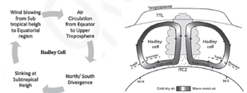
Azores High
Characteristics and Formation
- Location and Seasonality: The Azores High is a subtropical high-pressure system that is predominantly present over the eastern subtropical North Atlantic and affects western Europe, especially during the winter season.
- Anticyclonic Winds: This high-pressure system is associated with anticyclonic winds that circulate clockwise in the Northern Hemisphere due to the Coriolis effect. The system is formed by dry air aloft that descends in the subtropics, coinciding with the downward branch of the Hadley Circulation.
Effects and Environmental Impact
- Climate Impact: The presence of the Azores High influences weather patterns across the North Atlantic, including the Mediterranean climate of the Iberian Peninsula. It contributes to dry conditions and plays a role in the observed annual die-off of vegetation and decreasing precipitation levels.
- Water Precipitation: Research indicates an annual decrease in precipitation by 5-10 millimeters per year per decade in the Iberian Peninsula during the latter half of the 20th century. Predictions suggest a further reduction in precipitation by 15-20% by the end of the 21st century, affecting water resources and agriculture.
- Agricultural Effects: The changing precipitation patterns due to the Azores High have significant implications for agriculture in the Iberian region, potentially leading to water scarcity and affecting crop yields.
- Expansion Factors: The expansion of the Azores High has been linked to increased greenhouse gas concentrations and industrial development. This expansion can alter weather patterns further, exacerbating climate-related challenges in affected regions.
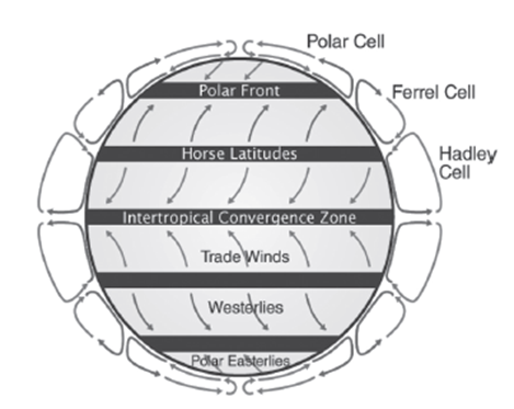
Understanding these atmospheric phenomena is crucial for predicting weather patterns, planning agricultural activities, and mitigating the impacts of climate change. The Sub-tropical High Pressure Belt and the Azores High are integral to the Earth’s climate system, influencing weather and climate on a global scale.
Horse Latitudes: An In-Depth Exploration
The Horse Latitudes are specific geographic regions around the globe, located approximately 30 degrees north and south of the Equator. These areas are pivotal in understanding global weather patterns, particularly due to their unique atmospheric conditions.
Characteristics
- Calm Winds: One of the most defining features of the Horse Latitudes is the presence of calm winds. This calmness is attributed to the high-pressure systems that dominate these latitudes, leading to stable and stagnant air masses.
- Low Precipitation: These regions receive little to no precipitation. The high-pressure system contributes to clear skies and limited cloud formation, which, in turn, reduces the chances of rainfall.
- Diverging Winds: Winds in the Horse Latitudes tend to diverge, flowing either towards the poles or the equator. This divergence creates two significant wind patterns:
- Prevailing Westerlies: Winds that flow towards the poles, characteristic of the Horse Latitudes, are known as the Prevailing Westerlies. They are crucial for weather patterns in the mid-latitudes.
- Trade Winds: Winds that flow back towards the equator are referred to as Trade Winds. These winds are essential for maritime navigation and have played a significant role in historical sea voyages.
High-Pressure System
The atmospheric conditions in the Horse Latitudes are dominated by an area of high pressure. This high-pressure system is responsible for the calm winds, sunny skies, and the scarcity of precipitation. The system acts as a blockade, preventing the movement of weather fronts and storm systems, which leads to the stable and dry conditions observed in these regions.
Etymology
The term “Horse Latitudes” has a historical context tied to the age of sail. As ships voyaged to the New World, they often became stalled in these high-pressure zones, where the absence of wind made it difficult to continue their journey. Many of these ships carried horses as part of their cargo. Faced with the dilemma of limited drinking water and no wind for propulsion, sailors were sometimes forced to throw their horse cargo overboard to conserve water, leading to the origin of the term “Horse Latitudes.”
Environmental and Climatic Implications
- Climate Impact: The Horse Latitudes play a significant role in shaping the climate of the surrounding regions. The dry and stable conditions influence the desert climates and semi-arid regions found at these latitudes.
- Ocean Circulation: The wind patterns associated with the Horse Latitudes also affect ocean currents, contributing to the circulation of warm and cold water across the globe.
The Horse Latitudes are more than just a navigational challenge of the past; they are integral to understanding global weather and climate patterns. Their unique atmospheric conditions influence not only the climate of adjacent regions but also global oceanic circulation patterns. The historical context of the term adds a layer of human interaction with these natural phenomena, showcasing the challenges and adaptations of early maritime explorers.
Sub-polar Low-Pressure Belt

Geographic Extent
- Location: This belt extends along the 60° latitudes, ranging between 55° and 65° in both the Northern and Southern Hemispheres. It encircles the Earth and is found just below the Arctic Circle in the north and above the Antarctic Circle in the south.
Formation
- Dynamic Induction: Unlike pressure belts closer to the equator, which are primarily influenced by thermal factors (heating and cooling of air), the Sub-polar Low Pressure Belt is dynamically induced. This means it forms through the movement and interaction of air masses.
- Convergence of Winds: The belt is characterized by the convergence of winds from two distinct sources: the warmer, subtropical air moving poleward and the colder, polar air moving toward the equator. This convergence zone is where the contrasting air masses meet and mix.
Atmospheric Processes
- Air Movement: The meeting of these air masses forces air upwards, creating an area of low pressure. As the air rises, it cools and expands, leading to the formation of clouds and precipitation, which are common features of this belt.
- Deflection and Descension: The Coriolis effect, a result of Earth’s rotation, deflects the rising air toward the poles and towards the subtropical high-pressure areas. In these high-pressure areas, the air descends, warming as it does so, and creates drier conditions. This movement of air from the sub-polar lows to the subtropical highs and back forms what is known as Ferrell’s Cell, a key component of the mid-latitude climate system.
Polar High Pressure Belt
Characteristics
- Persistent High Pressure: Near the poles, high pressure prevails throughout the year. This is largely due to the extremely low temperatures, which cool the air, increasing its density and causing it to sink, thus creating a high-pressure zone.
Factors Influencing Pressure
- Temperature: The cold temperatures are the primary reason for the high-pressure conditions, as cold air is denser than warm air.
- Air Movement: The air that rises in the Sub-polar Low Pressure Belt and moves toward the poles contributes to this high-pressure condition as it descends in the polar regions.
Geographic Variations
- Antarctic vs. Arctic: The high pressure is more pronounced over the landmass of Antarctica than over the Arctic Ocean. This difference is due to the greater extent of land in the Antarctic, which cools more efficiently than the ocean, enhancing the high-pressure conditions.
Polar Cell
- Circulation: The uplifted air at the sub-polar low that moves towards the poles and descends there, eventually returning to the sub-polar low, constitutes the Polar Cell. This cell is a critical component of the polar climate system, influencing weather patterns and climate conditions in these regions.
Shifting of Pressure Belts
The phenomenon of shifting pressure belts is a critical aspect of Earth’s climate system, influenced significantly by the planet’s axial tilt of approximately 23.5 degrees relative to the plane of its orbit around the Sun. This inclination plays a fundamental role in the seasonal variation of sunlight distribution across Earth’s surface, thereby affecting the heating of continents, oceans, and atmospheric pressure conditions.

Earth’s Axial Tilt and Seasonal Variations
- Axial Tilt: Earth is tilted on its axis by about 23.5 degrees. This tilt, combined with Earth’s orbit around the Sun, leads to variations in solar radiation received at different latitudes throughout the year. These variations drive seasonal changes in weather and climate.
- Heating Variability: Due to the axial tilt, the amount of solar energy reaching different parts of Earth changes over the year. The Northern and Southern Hemispheres experience opposite seasons; when it is summer in one hemisphere, it is winter in the other.
Shifting of Pressure Belts
- Original Position and Shift: Pressure belts, including the Equatorial low, the Subtropical highs, the Subpolar lows, and the Polar highs, would have remained static if not for Earth’s tilt. However, due to this tilt, these belts shift approximately 5 degrees northward or southward from their original positions in response to the overhead position of the Sun at the Tropics of Cancer and Capricorn during solstices.
- June 21 (Summer Solstice): The Sun is directly overhead at the Tropic of Cancer, leading to a northward shift of the pressure belts in the Northern Hemisphere.
- December 22 (Winter Solstice): The Sun is directly overhead at the Tropic of Capricorn, causing a southward shift of the pressure belts in the Southern Hemisphere.
- Equinoxes: On March 21 and September 23, when the Sun shines vertically over the Equator, the pressure belts tend to align closely with their mean positions, reflecting a more balanced distribution of solar heating across the hemispheres.
Climatic Implications
- Mediterranean Climate: The shifting of pressure belts, particularly between 30° and 40° latitudes, results in the Mediterranean climate, characterized by wet winters and dry summers. This is due to the movement of the Subtropical high-pressure belt, which influences the prevailing wind patterns.
- Winter: The Subtropical high-pressure belt shifts, allowing the Westerlies to bring moisture and cause rainfall.
- Summer: As the high-pressure belt moves, the region falls under the influence of dry Trade Winds, reducing the likelihood of rainfall.
Seasonal Changes in Climate
The shifting of pressure belts not only affects specific climate types like the Mediterranean but also has broader implications for seasonal weather patterns globally. These shifts influence the distribution of precipitation, the intensity and location of storms, and the general weather conditions experienced in various parts of the world throughout the year.
Understanding the dynamics of pressure belt shifts is crucial for meteorology, climate science, and for anyone involved in agriculture, water resource management, and environmental planning. This knowledge helps in predicting seasonal weather patterns, preparing for climate-related phenomena, and mitigating adverse effects on human activities and natural ecosystems.
Types of Wind
Understanding the classification and characteristics of winds is fundamental in meteorology and climatology, as winds play a crucial role in Earth’s weather patterns and climate systems. This explanation expands upon the provided details, offering a structured and in-depth look at the various types of winds, from surface to high-altitude phenomena.
1. Permanent Winds (Global/Planetary Winds)
Permanent winds, also known as global or planetary winds, are wind systems that persist throughout the year, moving from one latitude to another due to consistent atmospheric pressure differences. These winds include:
- Trade Winds: Found between the tropics and the subtropics (approximately 30°N and 30°S), trade winds blow from the high-pressure areas in the horse latitudes towards the equator. They are northeast in the Northern Hemisphere and southeast in the Southern Hemisphere, converging at the Intertropical Convergence Zone (ITCZ), a region also known as the doldrums.
- Westerlies: Located between 30° and 60° latitudes in both hemispheres, these winds flow from the subtropical high-pressure belts towards the polar low-pressure belts. They are responsible for much of the weather movements in the temperate latitudes.
- Polar Easterlies: These are cold, dry winds blowing from the polar high-pressure belts towards the low-pressure belts at around 60° latitude. They originate from the polar regions and flow east to west.
- Doldrums: A zone of low pressure and calm conditions found at the equator where the trade winds of the Northern and Southern Hemispheres meet. The lack of significant winds here historically troubled sailing ships.
- Horse Latitudes: Sub-tropical regions around 30°N and 30°S with high atmospheric pressure, characterized by calm winds and stable weather. Historically, ships reliant on wind power experienced difficulties in these areas.
2. Secondary Winds (Seasonal/Periodic/Regional Winds)
Secondary winds change direction or intensity with the seasons or are influenced by specific regional conditions. Examples include:
- Monsoons: Large-scale wind systems that reverse direction between summer and winter, significantly influencing the climate of large regions, especially in South Asia. Summer monsoons bring heavy rainfall, while winter monsoons are typically dry.
- Cyclones: Large-scale air mass circulation systems, with the air spiraling inward. In the Northern Hemisphere, they rotate counterclockwise, and in the Southern Hemisphere, clockwise. They can bring severe weather, including storms and heavy rainfall.
3. Tertiary Winds (Local Winds)
Tertiary or local winds are smaller-scale winds affected by local geography and temperature differences. Examples include:
- Sea Breeze and Land Breeze: Caused by temperature differences between land and sea. Sea breezes occur during the day as land heats up faster than water, causing air to flow from the sea to the land. Land breezes occur at night, in the opposite direction, as land cools down faster than the sea.
- Mountain and Valley Winds: At night, air cools faster at higher elevations, causing valley breezes. During the day, mountain slopes heat up, causing mountain breezes.
- Cold and Warm Winds: These winds are named for their temperature relative to the area they move into. Examples include the Mistral, a cold northerly wind from the Alps to the Mediterranean, and the Chinook, a warm, dry wind on the eastern side of the Rocky Mountains.
4. High Altitude Winds: Jet Streams
Jet streams are narrow bands of strong winds in the upper levels of the atmosphere. They flow from west to east and are typically found near the tropopause. Jet streams influence weather patterns and are crucial for aviation routes for efficiency and fuel saving.
| Feature | Trade Winds | Westerlies | Polar Easterlies |
| Location | In the tropics between the subtropical high-pressure belt and the equatorial low-pressure belt (30°N and 30°S). | From Subtropical High-Pressure Belts to Sub-Polar Low-Pressure Belts between 30° and 60°N/S of the Equator in the temperate latitudes. | From the polar high-pressure belt towards the Sub-Polar Low-Pressure Belt between 60°N to 90°N & 60°S to 90°S. |
| Direction | In the Northern Hemisphere, deflected to the right, known as North Trade Winds. In the Southern Hemisphere, deflected to the south, known as Southeast Trade Winds. | Deflect to their right in the Northern Hemisphere to become the South Westerlies, and to their left in the Southern Hemisphere to become the North Westerlies. | In the Northern Hemisphere, blow from the northeast (Northeast Polar Winds). In the Southern Hemisphere, blow from the southeast (Southeast Polar Winds), deflected westward by the Coriolis Effect. |
| Characteristics | Warm, moist, bring heavy rainfall to the eastern sides of tropical islands, constant speed, regular, associated with depressions and cyclones. | Strong, dominated by movements of cyclones and anticyclones, carry warm equatorial waters and winds to the western coasts of temperate lands. | Cold, originating from ice-capped regions but get heated over the oceans. |
| Coriolis Effect | Causes deflection to the right in the Northern Hemisphere and to the south in the Southern Hemisphere. | Causes deflection to the right in the Northern Hemisphere (South Westerlies) and to the left in the Southern Hemisphere (North Westerlies). | Causes deflection to the west in both hemispheres, termed as Polar Easterlies. |
| Rainfall Influence | Heavy rainfall on the eastern sides of tropical islands due to moisture they carry. | Responsible for carrying warm equatorial waters and winds to the western coasts of temperate lands, affecting rainfall distribution. | Limited direct influence on rainfall due to cold nature but can affect weather patterns when interacting with warmer air masses. |
| Other Names | Also known as permanent or constant winds, substituted by monsoon winds in the Indian and Pacific oceans in certain seasons. |
Seasonal winds
Seasonal winds are a fascinating aspect of Earth’s atmospheric dynamics, reflecting the intricate balance between temperature, pressure, and the Earth’s rotation. These winds are vital for understanding weather patterns, climate variability, and even the socio-economic aspects of certain regions, particularly in agriculture and water resources management.
Understanding Seasonal Winds
Definition and Characteristics
- Seasonal Winds are those winds that exhibit significant changes in direction, intensity, and duration over specific regions due to the seasonal variations in atmospheric pressure and temperature. They are part of the broader wind system but are distinctly influenced by seasonal shifts, which are themselves a result of the unequal heating of the Earth’s surface.
- Regional Influence: These winds are especially pronounced in certain regions where geographical features and latitudinal positioning amplify the effects of seasonal changes, leading to predictable and sometimes dramatic shifts in weather.
- Example: The most cited example of seasonal winds are the monsoon winds, which have a profound impact on the Indian subcontinent, Southeast Asia, and parts of Africa, bringing much-needed rainfall to support agriculture but sometimes causing devastating floods.
Mechanism
- Temperature and Pressure Variations: The primary driver behind seasonal winds is the differential heating and cooling of the Earth’s landmasses and oceans. This differential creates areas of high and low pressure that shift with the seasons, influencing wind patterns.
- Coriolis Effect: The rotation of the Earth affects wind direction, causing them to turn right in the Northern Hemisphere and left in the Southern Hemisphere, which plays a significant role in the movement of seasonal winds.
Types of Seasonal Winds
1. Monsoon Winds
- Origin: Derived from the Arabic word “Mausim,” meaning “season,” monsoons epitomize the concept of seasonal winds with their dramatic reversal of direction in response to seasonal changes in temperature and pressure.
- Characteristics: Marked by a shift from sea to land in the summer as the land heats up, creating low-pressure areas that draw moist air from the ocean, and a reversal from land back to the sea in winter as the land cools, creating high-pressure areas.
- Impact: Monsoons are crucial for the rain-fed agriculture prevalent in many parts of Asia and Africa, though their intensity and timing can vary, affecting crop yields positively or negatively.
2. Trade Winds
- Definition: These are steady, persistent winds that flow from east to west just north and south of the Equator. They are part of the global circulation system and are most consistent over the oceans.
- Formation: Trade winds are formed due to the Earth’s rotation and the presence of the subtropical high-pressure belt, blowing towards the equatorial low-pressure area.
- Significance: Historically, trade winds were crucial for sailing ships on transoceanic voyages, aiding in navigation and exploration.
3. Prevailing Westerlies
- Description: These winds blow from the west to the east in the mid-latitudes between 30° and 60° latitude. They arise from the high-pressure areas in the subtropics towards the low-pressure areas in the polar regions.
- Features: The prevailing westerlies are responsible for the weather patterns and climatic conditions in the temperate zones, including many of the world’s wine-producing regions.
- Influence: They are known for their role in facilitating the movement of weather systems across continents, particularly in the Northern Hemisphere.
Local Winds
Local winds are fascinating meteorological phenomena resulting from the uneven heating and cooling of the Earth’s surface, primarily affected by variations in land and water properties. These winds are not only essential for understanding local weather patterns but also for their implications on climate, ecology, and human activities.
Sea Breeze

Definition and Formation:
- A sea breeze is a local wind pattern that occurs during the day, flowing from the sea towards the land.
- Its formation is attributed to the differential heating rates of land and sea. During the day, land surfaces heat up more quickly and to a higher degree than water bodies, due to the lower specific heat capacity of land compared to water. This results in the air above land becoming warmer, lighter, and rising, creating a low-pressure area.
- Consequently, the cooler, denser, and more humid air over the sea moves towards the land to fill the low-pressure void, forming a sea breeze.
Implications:
- Sea breezes have a moderating effect on coastal temperatures, bringing cooler and more humid air inland, which can be particularly refreshing on hot days.
- They can also influence local weather conditions, such as promoting cloud formation and precipitation when warm, moist sea air rises over land.
Land Breeze
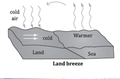
Definition and Formation:
- A land breeze is the nocturnal counterpart to the sea breeze, flowing from the land to the sea during the night.
- At night, the reversal of temperature gradients occurs as land surfaces cool down more rapidly than water bodies. This cooling makes the air above the land cooler, denser, and creates a high-pressure area.
- Air from the relatively warmer sea, where the air is lighter and has risen, causes a pressure difference that drives the cooler, denser air from the land towards the sea, generating a land breeze.
Implications:
- Land breezes contribute to the cooling of coastal areas at night and can affect marine conditions by pushing surface water away from the coast, sometimes leading to upwelling of deeper, nutrient-rich water.
Valley Breeze

Definition and Formation:
- A valley breeze is a daytime wind that moves from the valley floor up towards the mountains.
- This phenomenon occurs when solar radiation warms the valley floors and slopes, heating the air in contact with these surfaces. The heated air, being less dense, ascends the mountain slopes, creating a valley breeze.
- It is an example of an anabatic wind, which refers to winds that flow uphill driven by thermal convection.
Implications:
- Valley breezes can aid in dispersing pollutants from valley regions and contribute to a more pleasant climate by reducing temperatures during hot days.
Mountain Breeze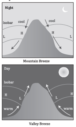
Definition and Formation:
- A mountain breeze occurs after sunset, flowing from the mountains down into the valleys.
- At night, the air in contact with the mountain slopes cools rapidly through radiation, becoming denser and heavier. This cool air then flows downhill into the valley, a process known as katabatic wind.
- If mountain slopes are snow-covered, these breezes can occur both at night and during the day, carrying cold, dense air into warmer valleys.
Implications:
- Mountain breezes are essential for temperature regulation in valley regions during the night and can significantly impact local climate patterns, including frost formation in agricultural areas.
These local wind patterns illustrate the dynamic interaction between the Earth’s surface and the atmosphere, significantly influencing weather, climate, and human activities in specific regions. Understanding these winds is crucial for meteorology, climatology, and environmental planning.
Difference between Seasonal and Local Winds
| Feature | Seasonal Winds | Local Winds |
| Cause | Caused by global atmospheric circulation patterns due to the Earth’s tilt, rotation, and the differential heating of Earth’s surface and atmosphere over the year. | Produced by the differential heating of the Earth’s surface in a more localized area, such as the different heating rates of land and water. |
| Constancy and Direction | Tend to be more constant with respect to direction, as they are influenced by large-scale atmospheric circulation patterns that change seasonally. | More variable and can change direction quickly due to local geographical features and daily variations in temperature. |
| Examples | Monsoon winds, which are a major seasonal wind system that brings significant rainfall to parts of Asia and Africa during certain times of the year. | Sea breezes and land breezes, which occur due to the differential heating and cooling rates of land and water, typically on a daily cycle. |
| Impact on Weather | Have a significant impact on the weather and climate patterns of large regions. For example, the northeast trade winds blowing across the Atlantic Ocean help to create the Gulf Stream, which in turn has a significant impact on the climate of Europe. | Impact local weather patterns, often in a beneficial way, such as cooling hot summer days. For example, sea breezes that blow from the sea to the land during hot days can help to reduce temperatures in coastal areas. |
| Role in Climate and Weather | Play a crucial role in shaping the climate of large areas, often contributing to seasonal weather patterns like wet and dry seasons. | Affect local weather conditions on a more immediate and smaller scale, such as providing relief from heat in coastal areas or contributing to local precipitation patterns through phenomena like mountain and valley breezes. |
POLAR VORTEX
The polar vortex is a significant meteorological phenomenon that impacts weather patterns across the globe, particularly in the polar regions and extending into the mid-latitudes. It’s characterized by a vast area of low pressure and cold air that surrounds the Earth’s poles. This section expands on the details provided, offering a deeper understanding of the polar vortex, its behavior, and its implications.
What is the Polar Vortex?

- Definition and Structure: The polar vortex consists of swirling cold air masses held in place by a low-pressure system. It is present around both the North and South Poles. The structure of the polar vortex is such that it forms a large cyclonic pattern, which circulates counterclockwise in the Northern Hemisphere and clockwise in the Southern Hemisphere, adhering to the Coriolis effect.
- Seasonal Variation: The strength and size of the polar vortex vary with the seasons. It strengthens in the winter due to the increased temperature contrast between the equator and the poles, leading to a more robust circulation of cold air. Conversely, in the summer, the temperature contrast diminishes, leading to a weakening of the vortex.
Dynamics and Behavior
- Winter Expansion: During the winter months in the Northern Hemisphere, the polar vortex expands, pushing the jet stream and cold air southward. This expansion can lead to significant outbreaks of cold air in lower latitudes, including the United States, where it may cause extreme cold conditions.
- Jet Stream Interaction: A healthy and strong polar vortex maintains a relatively circular path of the jet stream, which is crucial in demarcating colder air to the north from warmer air to the south. The jet stream’s role is pivotal in weather patterns, influencing precipitation and temperature distributions.
- Vortex Weakening: A weakened polar vortex can lead to distortions in its structure, sometimes causing portions of it to break off. This can disrupt the usual path of the jet stream, leading to a meandering pattern that allows cold air to plunge into mid-latitudes, bringing unusually cold weather to regions like the United States.
Consequences and Implications
- Stratospheric Warming Events: Sudden stratospheric warming events can induce significant weakening or even reversal of the polar vortex. These events can cause the jet stream to buckle, allowing cold polar air to escape southward and bring severe winter weather to mid-latitude regions.
- Climate Change Impact: The global temperature increase has led to more pronounced warming in the Arctic, a phenomenon known as Arctic amplification. This warming can influence the behavior of the polar vortex, potentially leading to more frequent and intense disruptions. The changing dynamics of the polar vortex are a subject of ongoing research, with implications for understanding future weather patterns and climate change impacts.
The polar vortex plays a crucial role in determining winter weather conditions in the Northern Hemisphere. Its interaction with the jet stream and response to seasonal changes and broader climatic shifts highlight the complexity of Earth’s climate system. Understanding the polar vortex is vital for meteorologists and climate scientists as they work to predict weather patterns and assess the potential impacts of climate change on extreme weather events.
Important Local Winds Across the Globe
Local winds are significant atmospheric phenomena shaped by the specific geographic, topographic, and atmospheric conditions of their regions. They can influence weather patterns, temperature, and humidity levels, impacting local climates, ecosystems, and human activities.
Bora
- Origin: Eastern Europe
- Direction: North-easterly towards northeastern Italy
- Characteristics: A cold, dry wind that can reach high speeds, causing significant cooling in the affected regions. The Bora is known for its sudden onset and can be particularly strong during winter.
Chinook
- Origin: Rocky Mountains
- Direction: Warm, dry westerly winds
- Characteristics: Known as “snow eaters,” Chinooks can cause rapid temperature increases, melting snow and warming the air significantly over short periods. They are a welcome break from the cold in winter months.
Föhn (Foehn)
- Origin: Northern side of the Alps, Switzerland
- Direction: Warm, dry southerly winds
- Characteristics: Föhn winds are known for their ability to rapidly increase temperatures and decrease humidity, leading to clear skies. They can cause “Föhnkrankheit,” a condition with symptoms such as headaches and irritability attributed to the rapid weather changes.
Harmattan
- Origin: Central Africa
- Direction: Dry, northerly wind
- Characteristics: The Harmattan carries dust from the Sahara Desert over West Africa, reducing visibility and sometimes affecting air quality and health. It is associated with cool conditions in the morning but can lead to high temperatures during the day.
Karaburan
- Origin: Central Asia
- Name Meaning: ‘Black storm’
- Characteristics: A spring and summer katabatic wind, Karaburan is known for carrying dust and sand, leading to severe dust storms that can significantly reduce visibility and impact the environment and human health.
Khamsin
- Origin: North Africa
- Direction: South-easterly towards the eastern Mediterranean
- Characteristics: A hot, dry wind carrying sand and dust, the Khamsin can cause sudden temperature increases and decrease air quality, affecting health and visibility.
Loo
- Region: Plains of India and Pakistan
- Characteristics: A hot and dry summer wind that can lead to extreme temperatures, often causing heatwaves that significantly impact human health and agriculture.
Mistral
- Origin: Central France and the Alps
- Direction: Cold, northerly wind towards the Mediterranean
- Characteristics: The Mistral clears the sky and cools the region, significantly influencing the climate and living conditions in the affected areas.
Nor’easter
- Region: Eastern United States, especially New England
- Characteristics: Strong winds from the northeast, often associated with severe winter storms bringing heavy snow, rain, and coastal flooding.
Nor’wester
- Region: New Zealand’s South Island
- Characteristics: This wind brings rain to the West Coast and warm, dry conditions to the East Coast, often accompanied by a distinctive arched cloud formation. It results from moist prevailing winds being uplifted over the Southern Alps.
Pampero
- Region: Argentina (Pampas)
- Characteristics: A very strong, cold, and occasionally violent wind, the Pampero is known for its sudden onset, cooling the region and sometimes bringing storms.
Simoom
- Region: Sahara, Israel, Jordan, Syria, Arabian Desert
- Characteristics: A strong, hot, desert wind, the Simoom carries dust and sand, significantly reducing air quality and visibility, and can be extremely hazardous to health.
Sirocco
- Direction: Southerly from North Africa to southern Europe
- Characteristics: A hot, humid wind carrying dust and sand from the Sahara, the Sirocco can cause temperature increases and affect air quality and mood.
Zonda Wind
- Region: Eastern slope of the Andes in Argentina
- Characteristics: A warm, dry wind that can cause significant temperature increases, the Zonda is associated with dry conditions and often precedes cold fronts, leading to rapid weather changes.

These winds have profound impacts on their respective regions, influencing weather patterns, ecological systems, and human activities. Understanding these winds is crucial for weather prediction, disaster preparedness, and mitigating their effects on agriculture, health, and daily life.
Jet streams
Jet streams are fascinating and significant atmospheric phenomena that play a crucial role in shaping weather patterns across the globe. They are essentially narrow bands of strong wind in the upper levels of the atmosphere. These winds are westerly, meaning they move from west to east, and are found at altitudes ranging from 6 to 14 kilometers (approximately 20,000 to 45,000 feet). Jet streams can reach speeds of up to 450 kilometers per hour (about 280 miles per hour) and are known for their wavy, meandering paths across both the Northern and Southern Hemispheres. Their behavior and movement are influenced by the distribution of temperature and pressure across the Earth.
Characteristics and Importance of Jet Streams
- High-Altitude Winds: Jet streams operate at high altitudes in the Earth’s troposphere, sometimes extending into the stratosphere. They form near boundaries of air masses with significant temperature differences, such as between polar and tropical air masses.
- Circumpolar Wind System: Given their global span, encircling the poles, jet streams are often referred to as the circumpolar wind system. This global reach allows them to connect and influence weather patterns across continents.
- Impact on Weather Patterns: Despite their high-altitude flow, jet streams have a profound impact on surface weather conditions. They steer cyclones and anticyclones, influence temperature distribution, and can lead to the formation of severe weather events.
Influence on Weather and Climate
1. Creation of Polar Vortex: The polar westerly jet streams transport cold polar air towards temperate regions. This movement can lead to severe cold waves in regions like North America and Eurasia during the winter months.
2. Monsoon Dynamics: The behavior of jet streams significantly affects monsoon patterns in South Asia. For instance:
- Sudden Burst of the Southwest Monsoon: The withdrawal of the polar westerly jet stream from the Indian subcontinent towards the north part of the Pamir range can lead to a sudden onset of the southwest monsoon, bringing significant rainfall to the region.
- Timing of the Monsoon: The rate at which the polar westerly jet stream withdraws can influence the timing of the monsoon’s onset. A slower withdrawal can delay the monsoon, while a faster retreat can lead to an earlier start.
- Monsoon Rainfall Intensity: The arrival of the tropical easterly jet stream over the Indian subcontinent can enhance the intensity of the southwest monsoon, leading to increased rainfall.
3. Western Disturbances and Rainfall: The polar westerly jet stream also plays a role in bringing moisture-laden clouds to India during the winter. These clouds, originating from cyclones formed over the Mediterranean Sea, can cause significant rainfall over northwestern India, crucial for winter crops like wheat.
4. Development of Super Cyclones: Under certain conditions, the energy and speed of the jet stream can be transferred to developing tropical cyclones. This transfer can intensify these systems, potentially leading to the formation of super cyclones with devastating impacts.
Classification of Jet Streams
| Classification | Description |
| Polar Front Jet Stream | Nature: Thermally induced, flowing west to east in a sinusoidal pattern.
Location: Between 40–60° latitude in both hemispheres. Altitude: Strongest at 200-300mb level. Characteristics: Non-continuous band, active all year, speeds of 160-200 km/hr. Impact: Significant influence on surface weather patterns. |
| Tropical Westerly Jet Streams | Nature: Flows throughout the year, conserving angular momentum.
Location: At the poleward limit of the Hadley cell, around 30° N and S latitude. Characteristics: More fixed pattern than the polar jet stream, maximum speeds up to 300 km/hr. Impact: Less effect on surface weather compared to polar front jets. |
| Tropical Easterly Jet | Nature: Seasonal, flowing east to west, thermally induced.
Location: Only in the Northern Hemisphere, active during the summer season. Characteristics: Influences monsoon patterns. Impact: Significant in modifying summer weather patterns, especially in influencing monsoon rains. |
| Geostrophic Winds | Nature: Winds flowing parallel to isobars, resulting from the balance between pressure gradient force and Coriolis force.
Location: Upper atmosphere. Characteristics: No friction at this altitude, winds adjust until Coriolis force equals pressure gradient force, leading to uniform velocity parallel to isobars. Impact: Fundamental in understanding wind patterns at high altitudes, though not a jet stream, it’s crucial for atmospheric dynamics. |
AIR MASS
Air masses play a fundamental role in determining the weather patterns across the globe. They are large bodies of air that have uniform properties of temperature and moisture content across vast horizontal expanses at a given altitude. The formation, characteristics, and impact of air masses on weather conditions are intricate and depend on various factors, including the nature of the surface over which they form and the prevailing atmospheric conditions.
Formation of Air Masses
The formation of air masses is contingent upon several basic conditions:

- Large and Relatively Stagnant Surface: Air masses form over large areas where the air is relatively stagnant and not influenced by divergent winds. This allows the air to acquire the temperature and moisture characteristics of the surface below.
- Homogeneous Surface Conditions: The underlying surface, whether land or water, must have homogeneous conditions in terms of temperature and humidity. This uniformity helps in creating an air mass with consistent properties.
Characteristics of Air Masses
Air masses are distinguished by several key characteristics:
- Uniformity in Horizontal Direction: Within an air mass, temperature and moisture content are relatively uniform when measured across horizontal planes. However, these properties can change with altitude, indicating a vertical variation.
- Influence of Origin Surface: The properties of an air mass primarily reflect the characteristics of the surface over which it originated. For example, air masses forming over oceans are generally moist, while those forming over deserts are dry.
- Impact on Weather: As air masses move, they bring their specific weather conditions to the areas they pass over. For instance, a moist air mass can lead to precipitation, while a dry air mass might result in clear skies.
- Extensive Reach: Air masses cover thousands of square kilometers and can extend from the Earth’s surface up to the stratosphere, illustrating their vast influence on the planet’s weather systems.
- Classification: Air masses are classified based on their temperature, humidity characteristics, and geographical origin. For example, a dry and warm air mass originating from a tropical region over a continent is termed a continental Tropical (cT) air mass.
- Front Formation: When two air masses with different temperatures and humidity levels approach each other, a front forms. This boundary between two air masses is often associated with significant changes in weather, including precipitation and shifts in temperature.
Types of Air Masses
Air masses are categorized into several types based on their source region’s nature (continental or maritime) and latitude (polar, tropical, arctic, etc.). Each type has distinct characteristics and impacts on the weather:
- Continental Polar (cP): Cold and dry, originating from high latitudes over land.
- Maritime Polar (mP): Cold and moist, forming over cold ocean waters.
- Continental Tropical (cT): Warm and dry, forming over hot desert areas.
- Maritime Tropical (mT): Warm and moist, originating from warm ocean waters.
The interaction between different air masses and their movement across the Earth’s surface are central to the dynamics of weather patterns, influencing everything from daily weather conditions to the development of storms and other meteorological phenomena.
Source Region
The concept of a source region is central to understanding how air masses acquire their distinct characteristics, which in turn influence weather patterns globally. Source regions are essentially geographical areas where air masses form and from which they derive their specific properties of temperature and moisture. These regions can vary widely, encompassing oceanic expanses, snow-covered landscapes, and vast deserts, among others. The nature of these source regions plays a pivotal role in determining the properties of the resulting air mass.
Dynamics of Air Mass Formation
The time it takes for an air mass to reach equilibrium with its source region’s surface conditions is a critical aspect of its formation. This equilibration period can range from a few days to approximately two weeks. The duration is influenced by the initial temperature difference between the air mass and the surface below, as well as the inherent properties of the source region itself.
- Colder Air Mass Formation: When the air mass is initially colder than the surface below, it warms up from the ground up. This warming induces convective currents that facilitate the vertical mixing of heat and moisture. Consequently, the air mass modifies relatively quickly, often within a shorter timeframe, because convective processes are efficient at redistributing energy and moisture throughout the air mass.
- Warmer Air Mass Formation: Conversely, if the air mass starts off warmer than the surface beneath it, cooling occurs from the bottom up. This cooling tends to stabilize the air, suppressing convective currents and thus slowing down the modification process. Cooling in this context is achieved through conduction and radiation, which are inherently slower than convective processes. As a result, it can take up to two weeks for such an air mass to develop its characteristic properties. Additionally, the physical thickness of a warm air mass is typically less than that of a cold air mass, further influencing the dynamics of air mass modification.
Importance of Source Regions
The significance of source regions lies in their ability to imprint specific thermal and hygrometric properties onto the air masses that form over them. These properties are not only a reflection of the source region’s surface characteristics but also determine the weather patterns that the air mass will influence as it moves away from its origin. For instance:
- Ocean Areas: Serve as source regions for maritime air masses, which are typically moist and can be either warm or cold depending on the latitude. These air masses play a key role in bringing precipitation to adjacent land areas.
- Snow-Covered Land: Forms the basis for cold, dry air masses, particularly in high-latitude regions. These air masses can lead to clear skies and lower temperatures as they move.
- Wide Deserts: Are the breeding grounds for hot, dry continental air masses that can cause heatwaves and dry conditions when they move into other regions.
Understanding the interaction between air masses and their source regions is crucial for predicting weather patterns and phenomena, ranging from daily weather changes to the development of complex weather systems.
Classification of Air mass
The classification of air masses is a fundamental aspect of meteorology, providing insight into the weather patterns and climatic conditions across different regions of the Earth. Air masses are classified based on their source region and the nature of the surface in that region. This classification helps meteorologists predict the potential weather changes that an air mass might bring as it moves from its source region to other areas.
Major Source Regions for Air Masses
There are five major source regions, each contributing distinct characteristics to the air masses that originate from them:
- Warm Tropical and Subtropical Oceans: These source regions are characterized by warm temperatures and high moisture content due to the vast expanses of ocean water. The air masses formed here, under the influence of anticyclonic conditions prevalent throughout the year, are known as maritime tropical (mT) air masses. They are significant contributors to precipitation in adjacent land areas when they move.
- Subtropical Hot Deserts: Located in the subtropical zones, these deserts are the source regions for continental tropical (cT) air masses. These air masses are dry and hot, affecting the regions they move over with clear skies and high temperatures.
- Relatively Cold High Latitude Oceans: These oceans, despite being in cold high latitudes, are not frozen and thus serve as source regions for maritime polar (mP) air masses. These air masses are cold but relatively moist, bringing cool, damp weather to lands they encounter.
- Cold Ice-Covered Continents in High Latitudes: The polar regions, characterized by snow and ice, are the birthplaces of continental polar (cP) air masses. These areas, often under cyclonic influence, produce cold, dry air masses that can drastically lower temperatures in affected regions.
- Permanently Snow-Covered Continents in the Arctic and Antarctica: The most extreme cold air masses, known as continental arctic (cA) air masses, originate from these regions. They are characterized by extremely cold and dry conditions, influencing severe weather patterns where they travel.
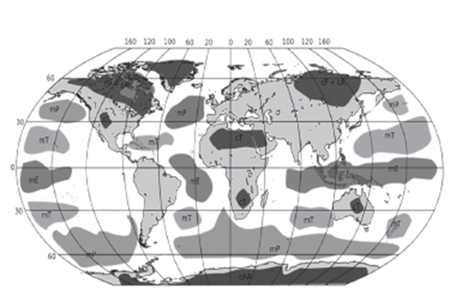
Types of Air Masses Recognized
The classification based on the source regions leads to the recognition of five primary types of air masses, each with unique characteristics that impact the weather differently:
- Maritime Tropical (mT): Warm and moist, originating over warm ocean waters, bringing humidity and potentially heavy precipitation to affected regions.
- Continental Tropical (cT): Hot and dry, formed over subtropical deserts, often associated with heatwaves and dry conditions.
- Maritime Polar (mP): Cold and moist, originating over the cold oceans of high latitudes, responsible for cool, wet weather.
- Continental Polar (cP): Cold and dry, formed over the ice-covered continents in high latitudes, bringing cold snaps and clear skies.
- Continental Arctic (cA): Extremely cold and dry, originating from the polar regions, associated with the harshest winter conditions.
This classification system allows meteorologists to predict and understand the vast array of weather phenomena that occur on Earth, from the intense heat of desert regions to the bitter cold of polar areas.
| Characteristics of the Major Air Masses | ||||
| Air Mass Type | Temperature (°C) | Stability | Source Regions | Humidity (g/kg) |
| Maritime tropical (mT) | 22 – 30 | Conditionally stable | Tropical and subtropical oceans, tropical rain forests e.g., Amazon and Congo Basins, parts of Southeast Asia | High (15-20) |
| Continental tropical (cT) | 30-42 | Conditionally stable during the day | Subtropical deserts e.g.Sahara and Australia (poorly developed in winter) | Moderately high (5-10) |
| Maritime polar (mP) | Winter: 0-10 Summer: 2-14 | Conditionally stable | Ocean, poleward from latitude 45° to 50° | Moderate (3-10) |
| Continental arctic (cA) | Winter: 55-35 | Very stable; generally, inversion occurs from surface to 2 km | Antarctica, Arctic Basin, Greenland, interior portions of Eurasia and North America | Low (0.05 – 0.22) |
| Continental polar (cP) | Winter: 30 -20
Summer: 5-15 |
Winter: Very stable; surface inversion Summer: Stable or conditionally stable | Interior of continents, between about latitudes 45° and 55° e.g., Northern part of North America, Eurasia | Extremely low in winter (0.06 – 0.2) and Moderate in Summer |
Modification of Air Mass
The concept of air mass modification is pivotal in the study of meteorology, as it provides insights into the dynamics of weather patterns and climatic changes. An air mass, a large body of air with uniform temperature and humidity characteristics, undergoes various modifications as it moves away from its source region. This transformation is essential for understanding how different weather phenomena occur.
Prerequisites for Air Mass Formation
- Stagnant Air: For an air mass to develop and acquire its distinctive properties, it initially requires a period of stagnation. This stagnation allows the air mass to equilibrate with the surface conditions of its source region, adopting specific temperature and moisture characteristics.
Factors Influencing Air Mass Migration
Several factors contribute to the movement of air masses from their source regions:
- Atmospheric Circulation: The general flow of the atmosphere acts to displace air masses, carrying them into new geographical areas beyond their origins.
- Nonuniform Heating: Variations in solar radiation across the Earth’s surface create differential heating, which, in turn, influences air movement. Areas that receive more heat experience lower pressure, drawing air masses toward them.
- Topographical Variations: The physical landscape, including mountains, valleys, and bodies of water, can redirect the flow of air masses, influencing their movement and eventual modification.
Mechanisms of Air Mass Modification
As air masses migrate, they undergo changes due to interactions with the underlying surface and the atmosphere. The extent and nature of these modifications depend on several factors:
- Original Characteristics: The temperature and humidity profile of the air mass at its source region sets the baseline for subsequent modifications.
- Trajectory: The path an air mass takes, including the types of land or water bodies it traverses, significantly affects its transformation.
- Surface Conditions: The characteristics of the surface over which the air mass moves—such as temperature, humidity, and texture—play a critical role in its modification.
- Duration of Modification: The time period over which an air mass remains over a particular area affects the degree to which it is modified.
Types of Modifications
Modifications to an air mass primarily occur through two interconnected processes:
- Interchange of Heat and Moisture: This involves the transfer of heat and moisture between the air mass and the surface below. This exchange can warm or cool the air mass, increase or decrease its humidity, and alter its stability.
- Vertical Movements: Large-scale ascents or descents within the air mass can induce changes. Ascending air may cool and condense, forming clouds and precipitation, while descending air can warm and clear clouds, often leading to more stable conditions.
Thermodynamic and Dynamic Modifications
- Thermodynamic Modifications: These occur due to the direct transfer of heat between the air mass and the surface, influenced by the nature of the surface (e.g., land or water) and the duration over which the air mass remains over it.
- Dynamic Modifications: Result from physical forces acting on the air mass, including friction with the Earth’s surface, and interactions with other air masses leading to ascending and descending motions. These motions can alter the air mass’s temperature, humidity, and stability, further influencing weather patterns.
The modification of air masses is a critical concept in meteorology, essential for understanding weather patterns and climate dynamics. These modifications can significantly alter the characteristics of an air mass, including its temperature, humidity, and stability. There are two principal types of modifications recognized in meteorology: thermodynamic and dynamic (or mechanical) modifications. These modifications generally do not occur in isolation but rather in combination, affecting the weather phenomena observed on the ground.
1. Thermodynamic Modifications
Thermodynamic modifications occur through the transfer of heat between the air mass and the surface over which it moves. This type of modification can change the temperature and moisture content of the air mass, influencing weather conditions such as temperature extremes, humidity levels, and the formation of fog or frost. The extent of thermodynamic modification depends on several factors:
- Nature of the Underlying Surface: Different surfaces (water, ice, forest, desert, etc.) have varying capacities to absorb and release heat, affecting the air mass differently. For example, water bodies tend to moderate temperatures, while concrete and sand can cause significant heating.
- Trajectory or Path: The path taken by the air mass from its source region influences the type and extent of modifications it undergoes. Air masses traveling over long distances over water tend to become more humid, while those moving over land may become drier and warmer or cooler, depending on the underlying conditions.
- Duration of Travel: The length of time an air mass spends over a particular surface affects how much it is modified. Longer durations allow for greater heat and moisture exchange between the air mass and the surface.
2. Dynamic or Mechanical Modifications
Dynamic modifications result from the physical movement and interaction of air masses with atmospheric phenomena such as cyclones, anticyclones, and surface friction. These modifications can alter the vertical and horizontal stratification of the air, affecting weather patterns through changes in stability, moisture, and wind patterns.
- Anticyclone: Associated with horizontal divergence and subsidence in the atmosphere, anticyclones lead to increased atmospheric stability. This stability inhibits cloud formation and precipitation, resulting in clear skies and potentially dry conditions.
- Cyclone: Characterized by horizontal convergence and ascending air, cyclones increase atmospheric instability. This instability enhances the potential for cloud formation, condensation, and precipitation, often leading to stormy weather.
- Surface Friction: As an air mass moves over the Earth’s surface, friction between the air and the ground modifies the lower layers of the air mass. This friction can lead to mixing of air at different heights, altering the temperature and moisture content. The mixing can warm or cool the air mass, indicated by the terms K (Kalt or cold) and W (warm), respectively.
Combined Effects
In practice, thermodynamic and dynamic modifications often occur simultaneously and interactively, leading to complex weather phenomena. For instance, a cold air mass moving over a warm ocean surface can experience thermodynamic warming and increased moisture (thermodynamic modification), while also being influenced by cyclonic activity leading to precipitation (dynamic modification).
Understanding these modifications is essential for predicting weather patterns, including the development of storms, heatwaves, cold spells, and precipitation events. Meteorologists use this knowledge to forecast weather, helping societies prepare for and mitigate the impacts of adverse weather conditions.
| Air Mass is Heated from Below | Air Mass is Cooled from Below |
| When an air mass moves over a surface that is warmer than its own, the lower layers of the air mass are heated. This results in an increased lapse rate and associated instability. | When an air mass moves over a surface that is colder than the lower layer of the air mass, the surface air is chilled, leading to a temperature inversion. |
| This condition facilitates the ascent of heated lower air, with the possibility of condensation, cloud formation, and precipitation. | This situation increases the stability of the air, which opposes the ascent of air, enhancing stability. |
| There is a differential rate of heating, with the maximum change occurring at the bottom (lower layer). Such an air mass is designated by the letter ‘K’ (cold or Kalt), indicating that the air mass is cooler than the surface over which it moves. | The air mass is designated by the letter ‘W’ (warm), indicating that the air mass is warmer than the surface over which it moves. |
| For example, if a polar air mass moves towards the tropical zone, it is cooler than the surface over which it moves, and the letter ‘K’ is attached to the concerned air mass. Thus, cP and mP become cPK and mPK respectively, indicating that continental polar (cP) and maritime polar (mP) air masses are heading towards warmer tropical areas. | For example, if a tropical air mass travels towards the polar region, it is warmer than the surface over which it moves, and the letter ‘W’ is attached to the concerned air mass. Thus, cT and mT become cTW and mTW respectively, indicating that continental tropical (cT) and maritime tropical (mT) air masses are heading towards colder polar areas. |
Fronts
Fronts are a fundamental aspect of meteorology, especially relevant in understanding weather patterns in midlatitude (temperate) regions, typically between 30° and 65° north and south of the equator. These boundaries between air masses with distinct characteristics such as temperature, humidity, and density play a crucial role in the weather systems of these regions.
Formation of Fronts
Frontogenesis
Frontogenesis refers to the process of front formation, a phenomenon often described metaphorically as a “war” between two contrasting air masses. This process is a key driver of temperate or extratropical cyclones, which are common in mid-latitude regions. The clash between cold and warm air masses leads to the development of a frontal zone, marking the boundary between these differing air masses.
Influence of the Coriolis Effect
The Coriolis effect significantly influences frontogenesis, causing the convergence of air masses to occur in an anticlockwise direction in the Northern Hemisphere and in a clockwise direction in the Southern Hemisphere. This effect, resulting from the Earth’s rotation, is pivotal in determining the movement and interaction of air masses across the globe.
Frontolysis
Conversely, frontolysis refers to the dissipation of a front, which occurs when one of the air masses prevails over the other, leading to the end of the frontal conditions.
Frontal Zone
The frontal zone is the transition area between the warm and cool air masses. Despite being a zone of transition, the boundary can sometimes be very sharp and narrow, indicating a clear demarcation between the contrasting air masses.
Characteristics of Fronts
Temperature Contrast and Frontal Thickness
There is an inverse relationship between the temperature contrast of two air masses and the thickness of the frontal zone. Air masses with a higher temperature difference do not merge easily, resulting in a thinner frontal zone. This characteristic is crucial in determining the structure and behavior of fronts.
Weather Instability
Frontal activity is often associated with weather instability, leading to cloud formation and precipitation. This instability arises from the ascent of warm air, which cools adiabatically as it rises, leading to condensation and precipitation. The nature and intensity of the weather phenomena associated with fronts depend on factors such as the slope of ascent and the amount of water vapor present in the ascending air.
Impact on Temperature and Pressure
A sudden change in temperature across the front can also lead to changes in atmospheric pressure. This interplay between temperature, pressure, and air movement is central to the dynamics of fronts and their impact on weather patterns.
Classification of Fronts Based
The classification of fronts based on their formation mechanism and associated weather phenomena is crucial for understanding the diverse impacts they have on the environment and human activities. Fronts can be classified into several types, with stationary fronts being a primary category. Here’s an in-depth look at stationary fronts and their characteristics:
Stationary Fronts
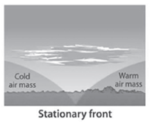
A stationary front forms when two air masses of different temperatures meet but neither is strong enough to displace the other. As a result, the front remains relatively stationary, with the boundary between the warm and cold air masses not moving significantly. This stagnation leads to prolonged weather patterns over the areas affected by the stationary front.
Characteristics
- Air Mass Movement: In the vicinity of a stationary front, the warm and cold air masses flow parallel to each other and the frontal boundary. This parallel flow prevents the advancement of either air mass, leading to the front’s stationary nature.
- Symbol Representation: On weather maps, stationary fronts are typically depicted with alternating warm and cold front symbols (semi-circles and triangles) pointing in opposite directions. This symbolization reflects the stalemate between the opposing air masses.
- Weather Patterns: The interaction between the warm and cold air masses at a stationary front can lead to the development of cumulonimbus clouds. These clouds are capable of producing significant weather events, including:
- Heavy Rainfall: The prolonged presence of a stationary front can lead to extended periods of rainfall over the same area. This can result in significant accumulations of precipitation, potentially causing flooding and related impacts.
- Cloud Formation: The lifting of warm, moist air over the cooler air mass at the front can lead to extensive cloud formation. This process can result in various types of precipitation, depending on the temperatures and humidity levels involved.
Weather Associated with Stationary Fronts
The weather associated with stationary fronts can vary but often includes prolonged periods of precipitation. The lack of movement of the front means that weather conditions can persist for several days, leading to the following impacts:
- Extended Rainfall: Areas affected by stationary fronts may experience days of continuous rain. This can lead to waterlogging, flooding, and disruptions to daily life and agriculture.
- Cloudiness: The extensive cloud cover associated with stationary fronts can lead to cooler temperatures and reduced sunlight, affecting outdoor activities and mood.
- Potential for Severe Weather: While not always the case, the conditions around stationary fronts can sometimes lead to severe weather events, including thunderstorms and heavy rainfall, particularly if the front becomes more active or interacts with other weather systems.
Cold fronts
Cold fronts are a significant meteorological phenomenon characterized by the movement of a cold air mass into a region occupied by a warmer air mass. This interaction between cold and warm air masses has profound effects on the weather, often leading to rapid and sometimes severe weather changes.
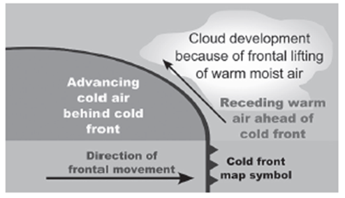
Formation of Cold Fronts
- Cold Air Advancement: A cold front forms when a cold air mass moves rapidly towards a warm air mass. The cold air, being denser and heavier, slides underneath the warm air, pushing the warm air upward.
- Characteristics: Cold fronts tend to move faster than warm fronts, approximately at speeds of about 65 kilometers per hour. This rapid movement contributes to the abrupt weather changes observed with cold fronts.
- Frontolysis: The process of frontolysis for a cold front begins once the warm air mass is entirely uplifted by the advancing cold air mass. This lifting can lead to the formation of various types of clouds and precipitation as the warm air cools and condenses.
Weather Associated with Cold Fronts
- Rapid Changes: The passage of a cold front typically leads to sharp and quick changes in weather. Temperatures can drop dramatically, sometimes more than 15 degrees Celsius within the first hour after the front passes.
- Precipitation and Cloudiness: Weather along a cold front is marked by a narrow band of cloudiness and precipitation. The initial interaction may result in the appearance of high-altitude cirrus clouds, followed by denser alto-cumulus clouds.
- Severe Weather Events: Cold fronts are often associated with severe weather conditions, including rapid showers, thunderstorms, and in some regions, such as parts of the United States, tornadoes. These severe storms are more common during the summer season in the warm sector ahead of the cold front.
Nature of Clouds Formed Along a Cold Front
- Cloud Progression: As the cold front moves into a region of warm air, it can lead to increased wind activity and the sequential appearance of different types of clouds. The progression typically starts with high-altitude cirrus clouds, moving to lower and denser alto-cumulus clouds.
- Cumulonimbus Clouds: At the actual front, the presence of dark nimbus and cumulonimbus clouds can lead to heavy rainfall. These clouds are indicative of the severe weather that can accompany cold fronts, including the potential for thunderstorms and heavy showers.
- Short Tenure but Violent Weather: Although a cold front typically passes through an area relatively quickly, the weather conditions it brings can be quite violent and abrupt, leading to significant changes in weather patterns over short periods.
Warm Fronts
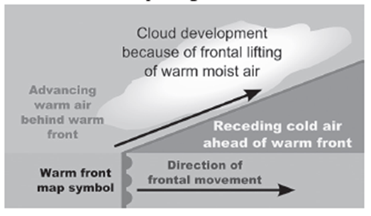
A warm front is the transition zone where a warm air mass moves to replace a retreating cooler air mass. Unlike cold fronts, the warm air in a warm front is less dense and, therefore, tends to ride over the cooler air mass rather than pushing it aside.
Characteristics
- Slope: The slope of a warm front is less steep compared to that of a cold front. This shallower slope is due to the less dense warm air gradually rising over the cooler air.
- Precipitation: The precipitation associated with a warm front typically exceeds that of a cold front. This is due to the extensive area covered by the warm air as it rises over the cooler air, leading to prolonged periods of precipitation.
- Frontolysis: Frontolysis in the context of a warm front begins when the warm air mass has moved completely above the cold air mass, effectively ending the frontal interaction.
Weather Associated with Warm Fronts
- Gradual Changes: Changes in temperature and wind direction are more gradual with warm fronts compared to the abrupt changes seen with cold fronts.
- Moderate Precipitation: Warm fronts are associated with moderate to gentle precipitation over a wide area, lasting several hours or more.
- Cloud Formation: The types of clouds formed ahead of and along a warm front include high-altitude cirrostratus clouds, which can create halos around the sun and moon, indicating the approach of a warm front.
Occluded Fronts
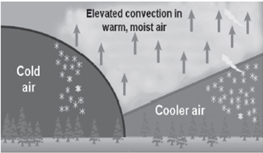
An occluded front occurs when a cold air mass overtakes a warm air mass and slides underneath it, effectively lifting the warm air off the ground. This usually happens in a low-pressure system where the cold front catches up to the warm front.
Characteristics
- Complex Weather Patterns: The weather along an occluded front can be complex, featuring a mix of weather types associated with both warm and cold fronts.
- Frontolysis: The process of frontolysis for an occluded front begins when the warm sector is fully overtaken by the cold air mass, leading to the dissipation of the front.
Weather Associated with Occluded Fronts
- Mixed Conditions: Weather conditions along an occluded front can include a variety of precipitation types, cloud formations, and temperature changes, reflecting the characteristics of both the overtaking cold front and the overtaken warm front.
- Mid-Latitude Cyclones: The formation of occluded fronts is closely related to the development of mid-latitude (temperate or extratropical) cyclones, highlighting their significance in the weather systems of western Europe and similar regions.
Temperature Inversion: An In-Depth Exploration
Temperature inversion is a fascinating meteorological phenomenon that reverses the typical temperature gradient in the Earth’s atmosphere, particularly within the troposphere, which is the lowest layer of the atmosphere where most of our weather occurs. To understand temperature inversion thoroughly, it is essential to first grasp the concept of the Normal Lapse Rate (NLR) and how inversion deviates from this norm.
The Concept of Normal Lapse Rate (NLR)
- Definition: The Normal Lapse Rate (NLR) refers to the rate at which atmospheric temperature decreases with an increase in altitude.
- Rate: Under typical conditions, the temperature drops approximately 1 degree Celsius for every 165 meters (or about 6.5 degrees Celsius per 1,000 meters) ascended in the troposphere.
- Significance: This rate is crucial for understanding weather patterns, cloud formation, and various atmospheric processes.
Understanding Temperature Inversion
- Definition: Temperature inversion is the meteorological phenomenon where this normal temperature gradient (i.e., cooler air above warmer air) is reversed, and the temperature increases with altitude.
- Characteristics: During a temperature inversion, a layer of warmer air sits above a layer of cooler air closer to the Earth’s surface.
- Causes:
- Static Atmospheric Conditions: Occurs in calm, stable conditions with little to no wind, especially during the night or early morning when the ground cools rapidly, cooling the air close to the surface.
- Air Movement: Both horizontal (advectional inversion) and vertical (subsidence inversion) movements of air can lead to temperature inversions. For example, warm air moving over a cold surface can cause advectional inversions, while descending air from higher altitudes warming adiabatically (without heat exchange) can lead to subsidence inversions.
Types of Temperature Inversions
- Ground or Surface Inversion: The most common type, occurring near the ground on clear, calm nights.
- Subsidence Inversion: Happens when a large-scale sinking of the Earth’s atmosphere causes air at higher altitudes to warm as it compresses, lying over cooler air below.
- Frontal Inversion: Occurs when warm air masses slide over cold air masses, typical around fronts.
Effects of Temperature Inversion
- Environmental and Weather Implications:
- Can lead to fog formation and cloudiness, impacting visibility.
- Affects air quality by trapping pollutants below the inversion layer, leading to smog and health issues.
- Influences flight operations due to changes in air density and visibility.
- Agricultural Impact: Can affect crop growth and pest behavior due to changes in ground-level temperature and humidity.
Duration and Occurrence
- Temperature inversions are generally of short duration, often dissipating with the morning sun or increasing wind which mixes the air layers. However, they are quite common and can be observed under various atmospheric conditions worldwide.
Desirable Conditions for Inversion Temperature
Long Winter Nights:
During winter nights, the Earth’s surface loses heat through terrestrial radiation more extensively due to the longer duration of darkness. This results in the ground and air close to the surface cooling down significantly. When outgoing radiation exceeds incoming solar radiation, the surface cools, leading to a temperature inversion as the warmer air lies above the cooler air near the surface.

Cloudless and Clear Sky:
A cloudless and clear sky facilitates the unobstructed loss of heat from the Earth’s surface into space. Clouds act as a blanket, trapping heat and preventing it from escaping. In their absence, heat radiates more efficiently into space, cooling the surface and the air near it, thus contributing to temperature inversion conditions.
Dry Air Near the Ground Surface:
Moist air tends to hold heat more effectively than dry air. When the air near the ground surface is dry, it has a limited capacity to absorb and retain heat radiated from the Earth’s surface. This enhances the cooling effect at the surface, promoting the development of a temperature inversion.
Slow Movement of Air:
Wind and air movements promote mixing of atmospheric layers, which can disrupt the formation of a temperature inversion. Slow-moving or stagnant air minimizes this vertical mixing, allowing the cooler, denser air to remain at the surface with warmer air above it.
Snow Covered Ground Surface:
Snow has a high albedo, meaning it effectively reflects incoming solar radiation back into the atmosphere rather than absorbing it. This reflection of solar energy prevents warming of the ground and the air immediately above it, facilitating a rapid cooling that is conducive to temperature inversion conditions.
Types of Temperature Inversion
Temperature inversions are classified based on the altitude at which they occur relative to the Earth’s surface and the nature of the air circulation involved. The main types include:
Surface or Ground Inversion:
Occurs close to the ground surface, typically during the night or early morning when the ground cools rapidly. It is the most common type of inversion and is heavily influenced by the factors listed above.
Subsidence Inversion:
Forms at higher altitudes when a large mass of air descends within a high-pressure system. As the air descends, it compresses and warms at a rate faster than the air it displaces, leading to an inversion.
Frontal Inversion:
Occurs when a cold air mass undercuts a warm air mass, leading to the warm air being lifted above the cold air. This setup can create a sharp temperature gradient between the two air masses, forming an inversion.
Elevated Inversion:
Takes place at higher altitudes, usually above the ground or surface inversions. It can be caused by various factors, including the movement of air masses, radiative cooling at high altitudes, or the presence of pollutants that trap heat.
Temperature inversions have significant implications for weather patterns, air quality, and climate. They can lead to the formation of fog, trap pollutants near the surface, and influence local weather conditions by stabilizing the lower atmosphere, preventing convection, and thus limiting cloud formation and precipitation. Understanding these inversions is crucial for meteorologists and environmental scientists as they study atmospheric conditions and their effects on the Earth’s environment.
Ground Inversion (Surface Temperature Inversion)
Ground inversion is a common atmospheric phenomenon that typically occurs during clear, calm nights. The process and its implications are as follows:

- Mechanism: This type of inversion happens when the Earth’s surface cools rapidly after sunset, due to the lack of cloud cover that would otherwise trap heat. As the ground loses heat through radiation, it cools the air in direct contact with it. This cooling process makes the surface air colder than the air above it, reversing the normal temperature gradient where air temperature decreases with altitude.
- Conditions Favoring Formation: Clear skies are crucial because clouds act as an insulating layer, reflecting heat back to the surface. Without clouds, the ground efficiently radiates heat into space, leading to rapid cooling. Calm air conditions are also important because wind can mix the air layers, disrupting the formation of a temperature inversion.
- Consequences: One of the most visible effects of ground inversion is the formation of fog, particularly when the cooled surface air reaches its dew point, causing water vapor to condense. This phenomenon is more common in higher latitudes but can also occur in lower and middle latitudes during cold nights, typically in the winter season. The inversion layer acts as a lid, trapping pollutants and moisture near the surface, which can lead to reduced air quality and visibility.
Temperature Inversion in Intermontane Valleys (Air Drainage Type of Inversion)
Intermontane Valley Inversion, or Air Drainage Inversion, occurs under specific geographical and meteorological conditions:
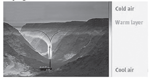
- Mechanism: In mountainous regions or deep valleys, the air near the sloping ground surfaces cools more quickly than the air at higher elevations. This rapid cooling causes the air to become denser and heavier. Due to the topography, this cold, dense air then drains downslope, settling in the valley floors. This movement creates a layer of cold air beneath warmer air above, inverting the typical temperature profile.
- Geographical Influence: The shape and orientation of valleys play a significant role in the formation of these inversions. Valleys that are oriented in such a way as to channel air effectively can enhance the cooling and drainage of cold air towards the bottom, intensifying the inversion effect.
- Consequences: Intermontane Valley Inversions can lead to prolonged periods of cold, stagnant air in valley bottoms. These inversions are particularly persistent during winter months when solar heating is insufficient to disrupt the inversion layer. Like ground inversions, they can trap pollutants and moisture, leading to poor air quality and specific weather patterns, such as freezing fog and frost in valleys, even when surrounding higher elevations experience warmer temperatures.
Both Ground Inversions and Intermontane Valley Inversions illustrate how the Earth’s surface features and atmospheric conditions interact to create unique weather phenomena. Understanding these inversions is crucial for predicting local weather patterns, managing air quality, and studying climate behavior in different geographical settings.
Frontal or Cyclonic Inversion
Frontal or Cyclonic Inversion occurs at the boundary between cold and warm air masses, which are respectively associated with cold and warm fronts in weather systems.
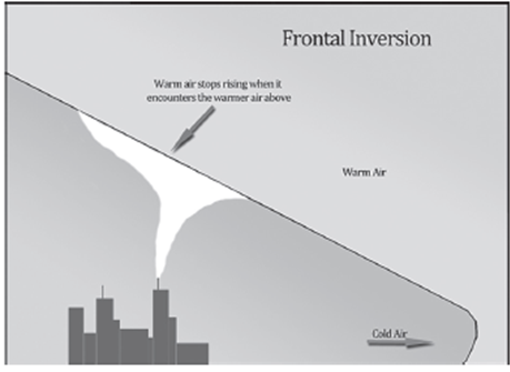
- Formation Mechanism: This type of inversion arises when a warm air mass and a cold air mass collide. The denser, heavier cold air slides beneath the lighter, warmer air, forcing the warm air to rise over the cold air. This action creates an inversion layer where the temperature increases with altitude, contrary to the normal decrease in temperature with height in the troposphere.
- Characteristics: Frontal inversions have a considerable slope, contrasting with the nearly horizontal layers seen in other types of inversions. This sloping nature is due to the dynamic interactions between moving air masses at the front.
- Geographical and Climatic Influence: These inversions are predominantly found in the temperate zones, where cold and warm air masses frequently interact, leading to cyclonic activity. The presence of frontal inversions is closely linked with cyclonic weather conditions, which can lead to various types of precipitation, such as rain, snow, or sleet, depending on the temperature profiles and moisture content of the interacting air masses.
- Stability: Frontal inversions are generally unstable and tend to be disrupted or destroyed by changes in weather patterns, particularly by the movement of the air masses away from the frontal boundary or by the introduction of energy (e.g., solar heating) into the system.
Subsidence Inversion (Upper Surface Temperature Inversion)
Subsidence Inversion is another critical type of temperature inversion, occurring at higher altitudes due to the vertical movement and compression of air masses.
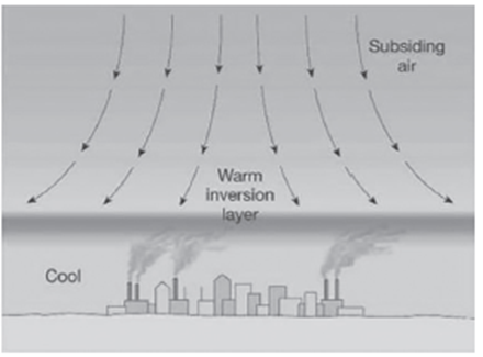
- Formation Mechanism: This inversion occurs when air from upper levels of the atmosphere descends toward the surface. As the air descends, it compresses and warms up due to the increasing atmospheric pressure. This warming of descending air can lead to a situation where air at higher altitudes is warmer than the air below, creating an inversion layer.
- Climatic and Geographical Occurrence: Subsidence inversions are common over northern continents in winter, where the atmosphere tends to be drier, and over subtropical oceans. These areas are often under the influence of large high-pressure systems, where air is naturally subsiding.
- Characteristics: Known also as upper surface temperature inversions, these phenomena occur in the upper parts of the atmosphere. They can lead to stable atmospheric conditions, suppressing vertical air movement and potentially trapping pollutants and moisture below the inversion layer.
- Impacts: Subsidence inversions contribute to clear skies and dry conditions below the inversion layer. In urban and industrial areas, these inversions can lead to episodes of poor air quality by trapping pollutants near the surface.
Effect of Temperature Inversion
Temperature inversions have a wide range of effects on the environment, weather patterns, and human activities. These effects can vary significantly depending on the type and duration of the inversion, as well as the geographic location where it occurs.
Forms of Precipitation and Cloud Types
Temperature inversions influence the types of clouds that form and the forms of precipitation that occur. Inversions can inhibit the formation of convection clouds, which are necessary for many types of precipitation, leading to conditions that are less conducive to rainfall. This can affect cloud formation by trapping moisture below the inversion layer, potentially leading to the development of low-lying clouds or fog instead of precipitation-producing clouds.
Air Pollution and Reduced Dispersion
One of the most significant impacts of temperature inversions is on air quality. Inversions can trap pollutants, such as dust particles and smoke, near the ground because the inversion layer acts as a barrier that prevents the vertical dispersion of air pollutants. This can lead to increased concentrations of pollutants in the air, which can have adverse health effects on populations in the affected areas.
Atmospheric Stability and Suppressed Air Movement
Temperature inversions contribute to atmospheric stability, limiting the vertical movement of air. This stability stops both the downward movement (subsidence) and upward movement (convection) of air, which can suppress cloud formation and precipitation. The stable conditions can also prevent the dispersion of fog and pollutants, leading to prolonged periods of poor air quality and reduced visibility.
Impact on Agriculture and Rainfall
The suppression of upward air movement during a temperature inversion means that moisture-laden air cannot rise, cool, condense, and fall as precipitation. This leads to reduced rainfall, which can have significant implications for agricultural productivity, especially in regions dependent on rain-fed agriculture. The lack of precipitation can lead to drought conditions, affecting crops and water supply.
Reduced Visibility and Transportation Disturbances
Fog formation is a common consequence of temperature inversions, particularly ground inversions, where warm air overlies cooler air near the surface. This can significantly reduce visibility, affecting road, air, and sea transportation. Reduced visibility can lead to delays and increased risks of accidents, disrupting travel and commerce.
Thunderstorms and Tornadoes
While temperature inversions generally suppress convection and storm formation, the release of energy when an inversion is lifted can lead to the rapid development of intense thunderstorms and tornadoes. This usually occurs when a strong inversion that has trapped energy near the surface is suddenly removed, allowing the pent-up warm, moist air to rise quickly, potentially leading to severe weather events.
Small Diurnal Temperature Variation
Temperature inversions can lead to small diurnal temperature variations, as the trapped air near the surface does not warm significantly during the day or cool much at night. This can result in unusually stable temperature conditions over the duration of the inversion.
Understanding the effects of temperature inversions is crucial for weather forecasting, air quality management, and planning in various sectors, including agriculture, transportation, and public health. Effective monitoring and predictive modeling can help mitigate some of the adverse effects associated with temperature inversions.
Tropical cyclones
Tropical cyclones are a type of extreme weather phenomenon characterized by their formation over warm tropical oceans and their potential to cause widespread damage upon reaching coastal areas. These systems are driven by a combination of atmospheric conditions, including low pressure at their center, warm temperatures, and the presence of moisture in the air.
Characteristics of Tropical Cyclones
- Inward Rotating Winds: Tropical cyclones feature winds that revolve inwardly towards an area of low atmospheric pressure. The direction of these winds is determined by the Coriolis effect—counterclockwise in the Northern Hemisphere and clockwise in the Southern Hemisphere.
- The Eye: At the center of a tropical cyclone is the “eye,” a region of relatively calm weather and low atmospheric pressure. The eye is surrounded by the eyewall, a ring of towering thunderstorms where the highest winds and most severe weather are found.
- Energy Source: The primary energy source for tropical cyclones is the warm water of the tropical oceans. The warm, moist air over the ocean surface rises and condenses, releasing latent heat, which in turn drives the cyclone’s circulation.
- Coriolis Force: The Coriolis force, a result of the Earth’s rotation, is essential for the cyclone’s rotating motion. It also helps maintain the low-pressure center by directing wind inward towards the eye.
- Destructive Elements: Tropical cyclones are associated with several destructive elements, including violent winds, torrential rainfall, and storm surges. These elements can lead to extensive property damage, flooding, and loss of life.
Types of Tropical Cyclones
Tropical cyclones are classified based on their maximum sustained wind speeds. This classification helps in understanding the potential damage they can cause and in issuing appropriate warnings.
- Tropical Depression: This is the weakest form of tropical cyclones, with maximum sustained winds of 38 mph (61 km/h) or less. Tropical depressions can still cause significant rainfall and flooding.
- Tropical Storm: A tropical storm has maximum sustained winds ranging from 39 to 73 mph (63 to 117 km/h). Tropical storms can cause considerable damage, especially from heavy rainfall and flooding.
- Hurricane/Typhoon: The term “hurricane” is used in the Atlantic and Northeast Pacific, while “typhoon” is used in the Northwest Pacific. These are powerful tropical cyclones with maximum winds exceeding 74 mph (119 km/h). They can cause catastrophic damage due to high winds, heavy rainfall, and storm surges.
- Major Hurricane: Classified as Categories 3, 4, and 5 on the Saffir-Simpson scale, major hurricanes have maximum winds greater than 111 mph (178 km/h). These storms are capable of causing devastating to catastrophic damage.
The Saffir-Simpson Hurricane Wind Scale
The Saffir-Simpson Hurricane Wind Scale is a 1 to 5 categorization based on a hurricane’s maximum sustained wind speed. This scale estimates potential property damage. Categories 3 and above are considered major hurricanes due to their potential for significant loss of life and damage.
Formation and Development
The formation of tropical cyclones involves several factors:
- Warm Ocean Waters: Sea surface temperatures of at least 26.5°C (79.7°F) are necessary to fuel the cyclone.
- Atmospheric Instability: Warm, moist air rising over hot ocean waters leads to the formation of thunderstorms.
- Moisture in the Atmosphere: Provides the necessary fuel for the thunderstorms that form the cyclone.
- Low Wind Shear: Low vertical wind shear allows the storm to organize and intensify by maintaining the structure of the cyclone.
Impact and Preparedness
Tropical cyclones pose significant risks to life, property, and the environment. Their impacts can be mitigated through effective preparedness measures, including:
- Early Warning Systems: Timely and accurate forecasts can save lives by allowing for early evacuations and preparations.
- Infrastructure Resilience: Building structures to withstand high winds and flooding can reduce property damage.
- Community Preparedness: Educating communities about evacuation plans, emergency kits, and cyclone safety can reduce the risk to life and limb.
Understanding tropical cyclones and their potential impacts is essential for minimizing the risks associated with these powerful storms.
Conditions Conducive for Tropical Cyclone Formation
- Sea Surface Temperature (SST): A fundamental requirement is a large expanse of ocean water with temperatures exceeding 27°C (80.6°F). This warm water acts as the energy source for the cyclone, providing the necessary heat and moisture to the atmosphere above.
- Coriolis Force: The Coriolis effect, resulting from the Earth’s rotation, is crucial for initiating the cyclonic vortex—a rotating movement of air. This force is negligible at the equator and increases with latitude; therefore, tropical cyclones typically form at least 5° away from the equator.
- Vertical Wind Shear: Low vertical wind shear, or small variations in wind speed and direction with height, is essential. High wind shear can disrupt the organization of a cyclone, preventing it from forming or leading to its weakening.
- Pre-existing Disturbances: A weak low-pressure area or a low-level cyclonic circulation can serve as a seed for the development of a tropical cyclone. These disturbances enhance the convergence of moisture and energy needed for cyclone formation.
- Upper-Level Divergence: Above the sea-level system, divergence (the outward flow of air at upper levels of the atmosphere) helps to evacuate air from the top of the system. This enhances the low-pressure area at the surface, allowing more air to rise and maintain the cyclone.
Reason for Tropical Cyclones to Occur on the Western Margin of Oceans
- Warm Ocean Currents: The western margins of oceans are typically warmer due to the westward flow of ocean currents (enhanced by the easterly trade winds). This results in a thicker layer of warm water, which is conducive to cyclone formation by providing ample moisture and heat.
- Cold Ocean Currents: Conversely, the eastern margins of oceans are often cooled by cold ocean currents, reducing sea surface temperatures and making conditions less favorable for cyclone development.
- El Niño Influence: During El Niño events, the eastern Pacific experiences warmer waters due to the weakening of the Walker Circulation. This anomaly can lead to the formation of hurricanes in the eastern Pacific by temporarily making the conditions similar to those typically found in the western margins of oceans.
- Latent Heat Release: The availability of warm waters (27°C or higher) is crucial for the condensation process, which releases latent heat. This heat release fuels the storm, maintaining or increasing its intensity. The warm water layer must be deep enough (around 60-70 meters) to prevent mixing with cooler subsurface waters, which could diminish the storm’s energy source.
- Coriolis Force and Latitude: The Coriolis force, vital for cyclone formation, is absent at the equator but becomes significant enough to initiate cyclonic activity around 5° latitude. Most cyclonic activity is observed between 10° and 20° latitude, where the Coriolis force is sufficiently strong to sustain cyclonic rotation.
These conditions outline the delicate balance of atmospheric and oceanic factors required for tropical cyclone development. Monitoring these conditions helps meteorologists predict the formation of cyclones, allowing for timely warnings and mitigating their potential impacts on human populations and infrastructure.
Stage of development of Tropical Cyclone
| Stage | Key Processes and Features |
| Formation and Initial Development | Movement of water vapor and heat from the warm ocean to the overlying air, primarily through evaporation from the sea surface, initiates the formation.
Convection and condensation of rising air above the ocean surface lead to the formation of vertical cumulus clouds. This stage is crucial for the accumulation of the energy needed for the cyclone to develop. |
| Mature Stage | Air moves upward in thunderstorms as the storm intensifies, spreading out horizontally at the tropopause level.
The spreading out of air at high altitudes creates a high-pressure area aloft, leading to accelerated downward air movement due to convection. Subsidence of air induces warming due to compression, forming a warm ‘Eye’ at the center of low pressure. A mature tropical cyclone features a concentric pattern of turbulent large cumulus thundercloud bands. |
| Modification and Decay | The weakening of a tropical cyclone begins when its source of warm, moist air is diminished or abruptly cut off, affecting core low pressure, internal warmth, and wind speeds.
This typically occurs after the cyclone makes landfall or moves over colder waters. The decay stage is marked by the disintegration of organized storm structure and a decrease in wind speeds. |
Structure of Tropical Cyclone
The structure of a tropical cyclone is a complex and fascinating subject, which is key to understanding the dynamics of these powerful weather systems.
Eye of the Tropical Cyclone
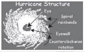
- Definition and Characteristics: The eye is the central region of a tropical cyclone, characterized by a roughly circular area of calm conditions, light winds, and relatively clear skies. This area is surrounded by the eyewall, where the most severe weather occurs. The eye is a hallmark feature of mature tropical cyclones.
- Conditions within the Eye: Inside the eye, conditions are markedly different from the surrounding areas. There is little to no precipitation, and it’s not uncommon for the sky to be clear, a phenomenon that can be quite striking amidst the turmoil of a tropical cyclone. The eye is an area of the lowest surface pressure within the storm, with the warmest temperatures found aloft, particularly at heights around 12 km (approximately 39,370 feet). Near the surface, the temperature differential is much less pronounced, with the eye being only 0-2°C warmer than its surroundings.
- Size Variation: The diameter of the eye can vary significantly among different cyclones, ranging from as small as 8 kilometers (about 5 miles) to over 200 kilometers (about 124 miles) across. The size of the eye can influence the intensity of the cyclone, with smaller eyes often associated with more intense storms.
Eyewall
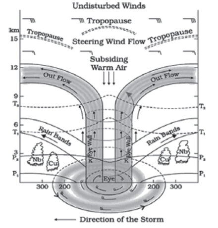
- Definition and Role: Surrounding the eye is the eyewall, a ring of towering thunderstorms where the highest winds and most intense rainfall are found. This area marks the boundary between the calm conditions of the eye and the more turbulent weather outside.
- Weather Dynamics: The eyewall is characterized by deep convection and severe weather conditions, including heavy rain, high winds, and thunderstorms. The strongest winds of a tropical cyclone occur in the eyewall, contributing to its destructive potential. The dynamics of the eyewall involve complex interactions between updrafts, which carry warm, moist air upward, and downdrafts, which bring cooler air down.
- Evolution and Changes: The eyewall can undergo processes such as eyewall replacement cycles, which can temporarily weaken a storm but may allow it to intensify afterward. These cycles involve the formation of a new eyewall outside the original one, which eventually replaces the inner eyewall.
Spiral Bands
- Arrangement and Appearance: Tropical cyclones feature spiral bands, also known as rainbands or feeder bands, which are elongated bands of clouds and thunderstorms that spiral outward from the eyewall. These bands can extend for hundreds of kilometers from the center of the storm and are integral to its structure and development.
- Function and Impact: Spiral bands contribute to the cyclone’s intensity by feeding it with additional moisture and warmth. They are associated with heavy rain and can cause significant flooding and wind damage well away from the storm’s center. The rotation of these bands is influenced by the cyclone’s overall circulation, contributing to the storm’s angular momentum.
Understanding the structure of tropical cyclones is crucial for predicting their behavior and potential impact. The eye, eyewall, and spiral bands each play distinct roles in the cyclone’s development, intensity, and movement. By studying these components, meteorologists can better forecast the path and strength of tropical cyclones, aiding in preparation and response efforts to minimize their impact on affected areas.
Vertical Structure of a Tropical Cyclone
Tropical cyclones are complex weather systems characterized by their structure which is divided into three main layers, each playing a significant role in the storm’s development and dynamics.
1. Lowest Layer (Inflow Layer)
- Extent: This layer extends up to 3 kilometers (km) above the sea level.
- Importance: It is the foundational layer of a tropical cyclone, crucial for generating the storm. Air moves inward towards the center of the storm at this level, bringing in moisture and heat from the ocean surface, which fuels the cyclone.
2. Middle Layer
- Extent: This layer spans from 3 km to 7 km above sea level.
- Characteristics: The primary cyclonic activity, including the most intense winds and heavy rainfall, occurs within this middle layer. It is here that the air begins to ascend due to the warm core of the cyclone, leading to the formation of clouds and precipitation.
3. Outflow Layer
- Extent: Located above 7 km, with the highest outflow observed at and above 12 km.
- Dynamics: In contrast to the inflow at the surface, the air in the outflow layer moves outward and upwards in an anticyclonic pattern. This layer helps in venting the heat away from the cyclone, which is essential for its sustenance and growth.
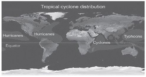
Naming Mechanism of Cyclones
The practice of naming cyclones serves several purposes, such as facilitating efficient communication, avoiding confusion, and making it easier for the media to report on these dangerous weather events.
Origins
- Start Date: The naming of cyclones in the Bay of Bengal and the Arabian Sea began in September 2004, prior to the Indian Ocean Tsunami in 2003-04.
General Rules
- Order and Alternation: Cyclones are named in alphabetical order. Names of women and men are alternated to ensure gender balance.
Responsible Organizations
- Regional Specialized Meteorological Centres (RSMCs) and Tropical Cyclone Warning Centres: Six RSMCs, including the Indian Meteorological Department, along with five regional Tropical Cyclone Warning Centres, are tasked with issuing advisories and naming cyclones in the North Indian Ocean region.
- WMO/ESCAP Panel on Tropical Cyclones (PTC): This panel, under the World Meteorological Organisation and the United Nations Economic and Social Commission for Asia and the Pacific, finalizes the list of names for cyclones. Advisories are issued to 13 member countries: Bangladesh, India, Iran, Maldives, Myanmar, Oman, Pakistan, Qatar, Saudi Arabia, Sri Lanka, Thailand, United Arab Emirates, and Yemen.
Naming List
- List of 169 Names: In April 2020, the IMD released a list of 169 cyclone names. These names were contributed by the 13 member countries, with each country suggesting 13 names.
This structured approach to naming cyclones not only aids in effective communication and management of storm warnings but also adds a layer of cultural significance, with each contributing country selecting names that are often reflective of their cultural and regional identities.
| Region | Name for Cyclone |
| Caribbean Sea | Hurricanes |
| Indian Ocean | Tropical Cyclones |
| Northern Australia | Willy-Willy |
| USA | Tornadoes |
| China Sea | Typhoons |
| Japan | Taifu |
| Philippines | Baguio |
Mid-Latitude Cyclones: A Comprehensive Overview
Mid-latitude cyclones, also known as extratropical cyclones, are immense weather systems that dominate the winter climate in regions like the United States. They are characterized by their capacity to generate a wide array of weather phenomena, ranging from heavy precipitation to strong winds and even thunderstorms. Understanding the intricacies of mid-latitude cyclones involves delving into their formation, dynamics, and the various factors influencing their behavior.
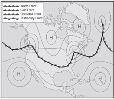
Formation Mechanism: Mid-latitude cyclones originate from the complex interaction between contrasting air masses, namely warm tropical air and cold polar air, along the polar front. The collision of these air masses initiates a process of cyclogenesis, wherein warm air is forced to ascend over the denser, colder air. As warm air rises, it undergoes adiabatic cooling, leading to condensation and cloud formation. This dynamic lifting of air sets the stage for the development of a low-pressure system characteristic of mid-latitude cyclones.
Role of the Jet Stream: The jet stream, a high-altitude, fast-flowing air current, plays a pivotal role in steering and shaping mid-latitude cyclones. Positioned at the boundary between warm and cold air masses, the jet stream guides the movement of these weather systems. As it meanders across the atmosphere, it can induce the formation of upper-level troughs, which in turn contribute to the intensification of cyclones. The juxtaposition of the low-pressure system associated with mid-latitude cyclones and the upper-level trough often leads to cyclogenesis.
Atmospheric Dynamics: Within mid-latitude cyclones, a dynamic interplay of atmospheric processes unfolds. At the surface, air converges towards the center of the low-pressure system, promoting upward motion. Aloft, air diverges, creating a region of lower pressure that further enhances the lifting of warm air. This process, known as vertical motion, fuels the development of clouds and precipitation within the cyclone. Additionally, the release of latent heat during condensation contributes to the intensification of the system, fostering instability and further enhancing convective activity.
Intensification Factors: Several factors contribute to the intensification of mid-latitude cyclones. Vertical wind shear, the variation in wind speed and direction with height, can enhance the cyclonic circulation and promote further development. Convective processes, driven by temperature differentials and atmospheric instability, also play a role in amplifying the cyclone’s strength. As the cyclone intensifies, the pressure gradient steepens, leading to stronger winds and more pronounced weather impacts.

High-Pressure Ridge and Amplification: Adjacent to the upper-level trough associated with mid-latitude cyclones, a high-pressure ridge often forms. This ridge facilitates the sinking motion of air, promoting a vertical circulation that deepens the trough and strengthens the cyclone. The interaction between the high-pressure ridge and the low-pressure system contributes to the amplification of winds both aloft and at the surface, enhancing the cyclone’s impact on the surrounding environment.
Anti-Cyclone: Understanding the Opposite of Cyclones
An anti-cyclone stands as the antithesis to a cyclone in meteorological terms, characterized by its outward-spiraling air circulation around a high-pressure center. While cyclones are known for their inward-spiraling winds and low-pressure centers, anti-cyclones exhibit the opposite behavior, often resulting in fair weather conditions.
Key Characteristics:
- Outward-Spiraling Air Circulation: Unlike cyclones, which draw air inward toward a low-pressure center, anti-cyclones feature air that spirals outward from a central high-pressure region. This outward movement sets the foundation for the distinct weather patterns associated with anti-cyclones.
- Clockwise Rotation (Northern Hemisphere): In the Northern Hemisphere, the winds within an anti-cyclone swirl in a clockwise direction around the high-pressure center. This rotation is a consequence of the Coriolis effect, which deflects moving objects to the right in the Northern Hemisphere and to the left in the Southern Hemisphere due to Earth’s rotation.
- Air Descent: Within an anti-cyclone, air tends to sink towards the Earth’s surface. This downward motion is a result of the high-pressure system’s stability, which encourages air parcels to descend, leading to clear skies and generally calm weather conditions.
- Fair Weather Association: Anti-cyclones are often synonymous with fair weather. The sinking air within the high-pressure center inhibits cloud formation and precipitation, resulting in predominantly clear skies, minimal atmospheric disturbances, and tranquil weather patterns. As a result, regions experiencing the influence of an anti-cyclone typically enjoy stable and pleasant weather conditions.
Illustrative Example: Consider a high-pressure system situated over a region in the Northern Hemisphere. As air converges towards this center, it experiences downward motion due to the high-pressure environment. The Coriolis effect causes the air to deflect to the right, initiating a clockwise rotation around the high-pressure center. This outward-spiraling motion of air results in the establishment of an anti-cyclone, characterized by its distinctive clockwise wind pattern and fair weather conditions.
Unraveling the Surge in Cyclone Frequency in the Arabian Sea
The Arabian Sea, traditionally considered less prone to cyclonic storms compared to the Bay of Bengal, has witnessed a notable escalation in cyclone activity in recent decades. This surge in cyclone frequency has spurred scientific inquiry into the underlying causes. By delving into historical patterns and contemporary climatic conditions, we can elucidate the intricate factors contributing to this phenomenon.
Historical Trends:
Historically, the Arabian Sea experienced fewer cyclones than its counterpart, the Bay of Bengal. An analysis spanning from the late 19th century to the turn of the millennium reveals a significant discrepancy in cyclone occurrences between the east and west coasts of the Indian subcontinent. The east coast, bordered by the Bay of Bengal, faced a higher incidence of severe cyclones compared to the west coast, which fronts the Arabian Sea.
Factors Behind Past Trends:
- Sea Surface Temperatures and Humidity: The Bay of Bengal’s conducive environment for cyclones is attributed to high sea surface temperatures and humidity levels, which foster active convection and cyclonic development.
- Wind and Air Current Dynamics: Persistent warm air currents and sluggish winds in the Bay of Bengal sustain elevated surface temperatures. Moreover, the inflow of freshwater from rivers impedes the mixing of warm and cool waters, further enhancing surface temperatures conducive to cyclone formation.
- Geographical Influences: The Bay of Bengal benefits from the influx of moisture from rivers and lacks significant landmasses that could obstruct cyclonic wind movement.
In contrast, the Arabian Sea historically experienced stronger winds, facilitating heat dissipation, and lacked consistent freshwater input, which promoted the mixing of warm and cool waters, thus mitigating surface temperatures.
Reasons for Increasing Cyclonic Activity in the Arabian Sea:
- Rising Sea Surface Temperatures: Global warming has engendered a rapid increase in sea surface temperatures in the Arabian Sea over the past century. This temperature surge creates conditions ideal for cyclone initiation and intensification.
- Energy Amplification: Elevated sea temperatures furnish ample energy for cyclone intensification. The presence of warm seawater layers, extending to considerable depths, expedites the development of cyclones, as exemplified by Cyclone Tauktae’s rapid intensification over just two days.
- Wind Shear Dynamics: Favorable wind shear conditions prevailing in the Arabian Sea contribute to the formation and intensification of cyclones.
- El Niño Modoki Events: The occurrence of El Niño Modoki events, characterized by atypical warming in the central Pacific, creates conditions conducive to cyclone genesis in the Arabian Sea.
Geographical Factors Contributing to Cyclone Formation:
- Tropical Zone Location: The Arabian Sea, along with the Bay of Bengal and the Gulf of Mexico, lies within the tropical zone, offering conducive conditions for tropical cyclone genesis.
- Warm Sea Surface Temperatures: These regions boast warm sea surface temperatures, fostering evaporation and cloud formation, essential prerequisites for cyclone initiation.
- Coriolis Force Influence: Situated between 10 to 30 degrees latitude, these regions benefit from the Coriolis force, which supports cyclone formation.
- Shallow Warm Waters: Shallow waters surrounding the Inter-Tropical Convergence Zone (ITCZ) provide additional warmth, augmenting energy for cyclone development.
- Ocean Current Influences: Warm ocean currents originating from equatorial regions impact sea surface temperatures, further bolstering the conducive environment for cyclone formation.
Thunderstorm
A thunderstorm is a meteorological phenomenon characterized by its violent and short-lived nature, typically accompanied by lightning, thunder, dense clouds, heavy rain or hail, and strong gusty winds. It occurs when layers of warm, moist air rise rapidly in a large, swift updraft to cooler regions of the atmosphere. This ascent of warm air, laden with moisture, creates an environment ripe for the formation of thunderstorms.
Conditions for Thunderstorm
Three primary atmospheric conditions are necessary for the formation of thunderstorms: moisture, instability, and lifting.
- Moisture: The presence of moisture in the lower atmosphere is crucial for thunderstorm development. This moisture provides the fuel needed for the formation of clouds and precipitation within the storm system.
- Instability: Atmospheric instability refers to the tendency of warm air to rise rapidly when compared to its surrounding environment. This instability can be caused by factors such as temperature differences within the atmosphere and the presence of an unstable air mass. As warm, moist air rises, it cools and condenses, forming clouds and eventually leading to the development of thunderstorms.
- Lifting: Mechanisms that lift warm, moist air from the surface are essential for initiating thunderstorm development. This lifting can occur through various processes, including orographic lifting (air forced to rise over elevated terrain), frontal lifting (convergence of air masses with different temperatures), and convective lifting (heating of the surface causing air to rise).
Stages of Thunderstorm Development
Thunderstorms typically progress through three distinct stages: the cumulus stage, the mature stage, and the dissipating stage.
- Cumulus Stage: The initial stage begins with the formation of towering cumulus clouds as warm, moist air rises and condenses into clouds. Updrafts within the developing storm system continue to strengthen, drawing in more warm air and moisture. This stage is characterized by rapidly rising air and the absence of precipitation at the surface.
- Mature Stage: During the mature stage, the thunderstorm reaches its peak intensity. Updrafts and downdrafts coexist within the storm, leading to the formation of precipitation such as heavy rain, hail, or even tornadoes. Lightning and thunder are frequent during this stage as strong vertical motion within the storm system generates static electricity.
- Dissipating Stage: As the storm exhausts its available energy and the supply of warm, moist air diminishes, the thunderstorm enters the dissipating stage. Updrafts weaken, and downdrafts dominate, causing precipitation to decrease. The storm gradually loses its organization, and cloud tops begin to flatten out. Eventually, the thunderstorm dissipates entirely, leaving behind clearing skies.
| Stage | Description |
| Cumulus Stage | · Solar insolation causes heating of the ground.
· Low pressure develops due to intense upliftment of an air parcel (convection). · Surrounding air rushes in to fill the low pressure. · Intense convection of moist hot air builds up a towering cumulonimbus cloud. |
| Mature Stage | · Characterized by intense updraft of rising warm air causing clouds to grow bigger and rise to greater heights, sometimes reaching the tropopause.
· Downdraft brings cold air and rain. · Violent gusts of wind indicate the thunderstorm, caused by intense downdraft. · Updraft and downdraft determine the thunderstorm’s path, often erratic. |
| Dissipating Stage | · Clouds extend to high altitudes where sub-zero temperatures prevail, leading to the formation of hail.
· Intense precipitation occurs, and within minutes, the storm dissipates, and clear weather prevails. |
Tornado
Understanding Tornadoes
A tornado is a formidable meteorological phenomenon characterized by a narrow, violently rotating column of air extending from a thunderstorm to the ground. This vortex of rapidly moving air, often accompanied by intense winds, poses significant threats to life and property.
Formation Mechanisms
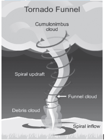
Tornado formation is a multifaceted process rooted in atmospheric dynamics. It begins with the creation of a horizontal spinning effect within a storm cell, triggered by fluctuations in wind speed and direction. As rising air currents within thunderclouds interact with this horizontal rotation, the spin is tilted vertically, initiating the formation of a tornado funnel. The wind speeds within this funnel can reach staggering velocities, exceeding 500 km/hr, inflicting severe damage to structures and endangering lives. Furthermore, tornadoes induce pressure drops at their centers, with air pressure plummeting to about 800 millibars. This rapid reduction in pressure can cause structures to collapse outward, exacerbating the destruction wrought by the tornado’s winds.
Origins of Tornadoes
The genesis of tornadoes hinges on four fundamental requirements: shear, lift, instability, and moisture. Wind shear, the variation in wind speed and direction with altitude, emerges as a critical factor in tornado formation. When wind shear is present, it sets the stage for the development of horizontal columns of rotating air, laying the groundwork for tornado genesis. As strong updrafts transport air from the ground to the atmosphere, these horizontal rotations are stretched vertically, marking the onset of storm development. Supercell thunderstorms, characterized by rotating updrafts known as mesocyclones, provide an ideal environment for tornado formation. These supercells, distinct from linear storm systems, exhibit intense rotation and spin, further enhancing the likelihood of tornado genesis. The convergence of a vertical, rotating column of air with a supercell thunderstorm can culminate in the descent of a tornado from the storm cloud.
Seasonal and Geographical Variability
Tornado occurrence displays pronounced seasonal and geographical variability. Spring emerges as the peak tornado season, characterized by stronger winds, increased wind shear, and atmospheric instability. Daytime heating further amplifies atmospheric instability, fostering convective activity conducive to tornado formation. Geographically, the United States stands at the forefront of tornado activity, hosting the most violent tornadoes globally. At any given time, approximately 1,800 thunderstorms are in progress worldwide, underscoring the pervasive nature of this meteorological phenomenon.
Difference Between Tornadoes and Cyclone
| Parameters | Tornadoes | Cyclones |
| Definition | It is a rotating column of air whirling at destructively high speeds, usually accompanied by a funnel-shaped downward extension of a thundercloud. | It is a large-scale air mass that rotates around a strong center of low atmospheric pressure. |
| Rotation | Clockwise in the Southern Hemisphere and counterclockwise in the Northern Hemisphere. | Clockwise in the Southern Hemisphere and counterclockwise in the Northern Hemisphere. |
| Intensity | Fujita, Enhanced Fujita, and Torro Scale | Beaufort Scale and Saffir-Simpson Scale |
| Most affected area | In areas where convergence of cold and warm fronts is common, i.e., US Midwest | Pacific Ocean |
| Frequency | More than a thousand reported in a year | 10-14 per year |
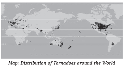
Extra-Tropical/Temperate Cyclone:
1. Extra-Tropical or Temperate Cyclones
Extra-Tropical or Temperate Cyclones are atmospheric phenomena that occur predominantly within the mid-latitudinal regions, spanning between 35° to 65° latitude, in both hemispheres.
2. Formation Mechanism:
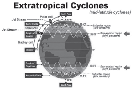
- These cyclones originate dynamically, primarily through a process known as frontogenesis, which involves the interaction of cold and warm fronts.
- Frontogenesis leads to the development of a low-pressure system, which forms the core of the cyclone.
3. Characteristics:
Movement Direction: Extra-Tropical Cyclones typically move from west to east. This eastward movement is more pronounced during the winter seasons when temperature gradients are steeper.
Seasonality: While they can occur throughout the year, their activity is particularly prominent during the colder months.
4. Alternate Names:
Extra-Tropical Cyclones are referred to by various names, each highlighting different aspects of their nature:
Temperate Cyclones: Reflecting their occurrence within the temperate regions.
Mid-Latitude Cyclones: Emphasizing their position within the mid-latitudes.
Frontal Cyclones: Denoting their formation through the interaction of different air masses along fronts.
Wave Cyclones: Referring to the characteristic wave-like patterns often seen in their frontal systems.
5. Key Components:
Fronts: These cyclones are characterized by the presence of different fronts, including warm fronts, cold fronts, and occluded fronts. The interaction between these fronts drives the cyclonic activity.
Low-Pressure System: At the core of the cyclone lies a region of low atmospheric pressure, which intensifies as the cyclone develops.
Associated Weather Phenomena: Extra-Tropical Cyclones bring a variety of weather conditions, including precipitation, strong winds, and temperature fluctuations, impacting regions over which they pass.
6. Importance and Impact:
Extra-Tropical Cyclones play a significant role in shaping weather patterns and can have profound impacts on regions they affect.
They are responsible for a range of weather phenomena, including rain, snow, thunderstorms, and even severe weather events such as blizzards and storms.
These cyclones are crucial for redistributing heat and moisture across the Earth’s surface, contributing to the regulation of global climate systems.
Polar Front Theory
The Polar Front Theory is a fundamental concept in meteorology that explains the formation of mid-latitude cyclones, also known as temperate cyclones or extratropical cyclones. It describes the interaction between contrasting air masses, specifically warm-humid air from the tropics and cold-dry air from the poles, leading to the development of a distinct frontal boundary known as the polar front.
Formation of Polar Front:
When warm air masses from the tropics meet cold air masses from the poles, the warm air is forced to rise over the denser, colder air due to its buoyancy. This upward movement of warm air leads to a decrease in pressure at the surface, creating a void or vacuum. Surrounding air rushes in to fill this void, resulting in the convergence of air masses. The Coriolis effect, caused by the Earth’s rotation, further influences the direction of movement, leading to the formation of cyclonic circulation patterns.
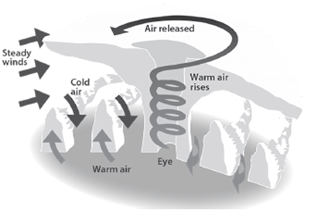
Development of Cyclones:
The development of temperate cyclones, also known as mid-latitude cyclones, can be categorized into several stages:
- Cyclogenesis: This initial stage involves the formation of a wave or disturbance along the polar front due to the temperature contrast between air masses. As warm air rises and cold air sinks, a frontal wave begins to develop.
- Open Wave: In this stage, the frontal wave intensifies, leading to the formation of a low-pressure system at the surface. The cold front and warm front become more pronounced as the cyclone matures.
- Mature Stage: At this point, the cyclone reaches its peak intensity. The cold front advances more rapidly than the warm front, leading to the occlusion of the warm sector. Intense precipitation and strong winds are common in this stage.
- Occlusion: As the cold front catches up to the warm front, the warm air mass is lifted completely off the surface, resulting in the occlusion of the cyclone. This marks the beginning of the decay phase.
- Dissipation: In the final stage, the cyclone dissipates as the temperature contrast weakens, and the circulation pattern breaks down. The system loses its organization, and the weather conditions return to a more stable state.
Development of Temperate Cyclones
Temperate cyclones, also known as extratropical cyclones or mid-latitude cyclones, are dynamic weather systems characterized by the interaction of contrasting air masses along frontal boundaries. Understanding their development is essential for forecasting and understanding weather patterns in temperate regions.
Key Development Stages:
- Air Mass Interaction: In the northern hemisphere, warm air flows northward while cold air moves southward along the frontal boundary. This interaction sets the stage for the development of a cyclonic circulation pattern, driven by the Coriolis force.
- Cyclonic Circulation: As the pressure drops along the frontal boundary, warm air is forced to move northward while cold air moves southward, resulting in an anticlockwise cyclonic circulation in the northern hemisphere. This circulation pattern is a result of the Coriolis force deflecting moving air masses.
- Frontal Structure: The cyclonic circulation leads to the formation of a well-defined extratropical cyclone characterized by a warm front and a cold front. The warm front marks the boundary where warm air advances over cold air, while the cold front represents the leading edge of advancing cold air.
- Precipitation: Within the warm sector, pockets of warm air exist between the advancing warm front and the retreating cold front. As warm air glides over the denser cold air, it rises, cools, and condenses, resulting in the formation of precipitation. Clouds form ahead of the warm front, producing a series of precipitation bands.
- Cold Front Interaction: Meanwhile, the cold front approaches from behind, pushing the warm air upward. This uplift of warm air leads to the development of cumulus clouds along the cold front. The cold front typically moves faster than the warm front, eventually overtaking it.
- Occlusion and Dissipation: As the cold front catches up to the warm front, the warm air is completely lifted off the surface. This occlusion process marks the final stage of the cyclone’s life cycle. The cyclone dissipates as the temperature contrast weakens and the circulation pattern breaks down.
- Frontogenesis and Duration: The processes of wind circulation, both at the surface and aloft, are closely linked. Temperate cyclones involve intense frontogenesis, primarily occlusion-type fronts. These cyclones typically last for about 3 to 10 days, moving in a west to east direction. The movement of these weather systems is influenced by the orientation of the polar jet stream in the upper troposphere.
Characteristics of Temperate Cyclones
| Characteristics | Description |
| Size and Shape | · Asymmetrical shape resembling an inverted ‘V’.
· Typically stretch over 500 to 600 kilometers. · May spread over a distance of up to 2500 kilometers in the case of phenomena like the Polar Vortex. – Height ranges from 8 to 11 kilometers. |
| Wind Velocity and Strength | · Winds are stronger in the eastern and southern parts, with North America experiencing greater strength and velocity compared to Europe.
· Wind speed tends to increase as the cyclone approaches but decreases after its passage. |
| Orientation and Movement | · Jet streams play a significant role in temperate cyclone formation.
· Their path is influenced by the jet streams. · Oriented east-west due to movement with the westerlies (Jet Streams). · Movement varies based on the direction of the storm front, i.e., east-west, northward, or southward. |
| Structure | · The north-western sector is cold, while the north-eastern sector is warm.
· This is due to cold air masses in the north and warm air masses in the south pushing against each other and rotating anti-clockwise in the northern hemisphere due to the Coriolis effect. |
| Associated Weather | · Arrival of temperate cyclones is indicated by a drop in temperature, decrease in mercury level, wind shifts, halo around the sun and moon, and a thin layer of cirrus clouds.
· This progresses to drizzle and eventually torrential downpour. · The arrival of a warm front halts the decrease in mercury level and initiates a temperature increase. · Rainfall ends, leading to clear weather until an anticyclonic cold front arrives, bringing a drop in temperature, cloudiness, and rain with thunder. · Clear weather resumes afterward. · Slow-moving cyclones with significant differences in rainfall and temperature between the front and back may experience increased rainfall. · They are often accompanied by anticyclones. |
Distribution of Temperate Cyclones
Temperate cyclones, also known as midlatitude or extra-tropical cyclones, are dynamic weather systems that form in the midlatitude regions of the world. They exhibit a distinct distribution pattern across the globe, with seasonal variations influencing their prevalence.
Prevalence and Distribution:
- Temperate cyclones predominantly form in the midlatitude regions, beyond the tropical zones.
- Their distribution across the globe reveals a well-defined zone, indicating regions where these cyclones are more likely to occur.
- While they can occur throughout the year, their frequency varies with seasonal changes.
Seasonal Occurrence:
- Winter: Temperate cyclones are most common during the winter months due to higher temperature disparities. This season provides optimal conditions for their formation and sustenance, leading to increased frequency.
- Late Autumn and Early Spring: These transitional seasons also witness significant activity of temperate cyclones, albeit to a lesser extent compared to winter.
- Summer: During summer, temperate cyclones tend to migrate northward. Consequently, their occurrence decreases in midlatitude regions, shifting towards higher latitudes.
Associated Weather Patterns:
- Temperate cyclones are often associated with rainstorms and overcast weather, particularly during their peak seasons in winter, late autumn, and early spring.
- While the subtropics and warm temperate zones experience fewer temperate cyclones during summer, regions such as the Bering Strait, the United States, and the Russian Arctic witness a concentration of storm activity during this time.
Water in the Atmosphere
Water exists in the Earth’s atmosphere in various forms, including solid, liquid, and gaseous states. The presence of water in the atmosphere is crucial for various atmospheric processes and has significant implications for weather and climate.
Forms of Water in the Atmosphere:
- Solid: This refers to water in the form of ice crystals or snow particles suspended in the air. Solid water in the atmosphere contributes to the formation of clouds and precipitation.
- Liquid: Liquid water in the atmosphere exists primarily in the form of cloud droplets or raindrops. These droplets form when water vapor condenses onto microscopic particles known as cloud condensation nuclei.
- Gaseous: Water vapor, the gaseous form of water, is the most abundant form of water in the atmosphere. It is invisible to the naked eye and plays a crucial role in the Earth’s energy balance and various atmospheric processes.
Sources of Atmospheric Moisture:
The moisture present in the atmosphere originates from various sources:
- Evaporation: Water bodies such as oceans, lakes, and rivers continuously release water vapor into the atmosphere through the process of evaporation, wherein liquid water changes into water vapor due to heat energy from the sun.
- Transpiration: Plants also contribute moisture to the atmosphere through a process called transpiration, wherein water is absorbed by plant roots and released into the air through tiny pores on the leaves.
Processes Involving Atmospheric Water:
Several key processes govern the movement and distribution of water in the atmosphere:
- Evaporation: The conversion of liquid water into water vapor by absorbing heat energy from the surroundings.
- Transpiration: The release of water vapor from plants into the atmosphere through their leaves.
- Condensation: The process by which water vapor condenses back into liquid water or ice crystals, leading to the formation of clouds and fog.
- Precipitation: The release of condensed water vapor in the form of rain, snow, sleet, or hail, which falls to the Earth’s surface.
Humidity:
- Specific Humidity: It refers to the actual mass of water vapor present in a unit mass of air. Specific humidity is expressed in grams of water vapor per kilogram of air.
- Absolute Humidity: This term denotes the total mass of water vapor present in a given volume of air. Absolute humidity is measured in grams per cubic meter.
- Relative Humidity: Relative humidity is the ratio of the amount of moisture present in the air to the maximum amount it can hold at a particular temperature, expressed as a percentage. It indicates how close the air is to saturation.
- Dew Point: The dew point temperature is the temperature at which air becomes saturated with water vapor and starts to condense into liquid water. It represents the point at which relative humidity reaches 100%.
Evaporation and Condensation
Evaporation:
Evaporation is the process by which liquid water transforms into water vapor or gas. It is a fundamental part of the Earth’s water cycle and plays a significant role in the distribution of water throughout the atmosphere. The process of evaporation occurs continuously in nature, driven primarily by the input of solar energy and influenced by various factors.

Nature of Evaporation:
Evaporation occurs when heat energy from the sun is absorbed by the surface of a liquid, causing the water molecules to gain enough energy to escape into the air as vapor.
It is a spontaneous process and does not require boiling temperature for water to evaporate.
Approximately 90% of the moisture entering the atmosphere does so through evaporation, making it a crucial component of the water cycle.
Factors Affecting Evaporation Rate:
Amount of Water Available: The availability of water directly affects the rate of evaporation. More water leads to more molecules available for evaporation.
Temperature: Higher temperatures result in increased kinetic energy of water molecules, leading to higher rates of evaporation. This is because higher temperatures provide more energy for water molecules to escape into the air.
Area of Evaporating Surface: The larger the surface area exposed to the air, the higher the rate of evaporation. This is because a larger surface area allows for more water molecules to escape into the atmosphere.
Wind Speed: Wind removes the saturated air near the evaporating surface, replacing it with drier air, which enhances evaporation. High wind speeds facilitate faster evaporation rates by maintaining a concentration gradient between the evaporating surface and the surrounding air.
Air Pressure: Atmospheric pressure influences evaporation by exerting force on the evaporating surface. Lower atmospheric pressure results in faster evaporation rates because less pressure allows water molecules to escape more easily.
Composition of Water: The presence of salts or solutes in water reduces its evaporation rate. Freshwater evaporates more readily than saltwater due to the lower vapor pressure caused by dissolved salts.
Condensation:
Condensation is the opposite process of evaporation, where water vapor transforms back into liquid water. It occurs when the air cools and reaches its dew point temperature, causing the water vapor to condense into droplets or form fog or clouds.
Nature of Condensation:
Condensation occurs when air becomes saturated with water vapor, either by cooling or by adding more moisture.
It is a crucial process in the formation of clouds, fog, and precipitation.
Condensation releases latent heat energy into the atmosphere, contributing to weather dynamics.
Factors Affecting Condensation:
Temperature: Lower temperatures promote condensation by reducing the capacity of air to hold moisture, leading to the saturation of air and subsequent condensation.
Humidity: Higher humidity levels increase the likelihood of condensation by bringing the air closer to its dew point temperature.
Presence of Condensation Nuclei: Microscopic particles such as dust, pollen, or salt crystals act as condensation nuclei, providing surfaces for water vapor to condense onto, thus facilitating condensation.
Dew:
- Definition: Dew refers to the moisture that forms as water droplets on cooler surfaces of solid objects, such as stones, grass blades, and leaves, when they come into contact with humid air.
- Ideal Conditions for Formation:
- Clear sky: Clear skies allow for radiational cooling, which is essential for dew formation.
- Calm air: Minimal wind prevents the disturbance of the dew-forming process.
- High relative humidity: High humidity levels increase the likelihood of dew formation.
- Cold and long nights: Lower temperatures during extended nighttime provide optimal conditions for dew formation.
- Dew point above freezing point: Dew forms when the dew point temperature is above the freezing point, ensuring that water droplets remain in liquid form.
Frost:

- Definition: Frost forms on cold surfaces, such as grass, when condensation occurs below the freezing point. Excess moisture is deposited as minute ice crystals instead of water droplets.
- Ideal Conditions for Formation:
- Similar to dew formation but with the dew point temperature below freezing.
- Clear sky, calm air, high relative humidity, cold and long nights.
- Formation Process: Frost may also form through sublimation, where water vapor rapidly cools and forms ice directly without transitioning into liquid form.
Fog:
- Definition: Fog is a dense cloud that hangs low to the ground and consists of tiny water droplets or ice crystals suspended in the air. It reduces visibility compared to mist due to its denser nature.
- Types of Fog:
- Radiation Fog: Forms through radiation cooling, causing moist air near the ground to cool to its dew point, often during clear nights.
- Advection Fog: Forms when moist air moves over a colder surface, leading to cooling and condensation.
- Frontal Fog: Associated with frontal zones and passages, including warm-front pre-frontal fog, cold front post-frontal fog, and frontal-passage fog.
- Ice Fog: Composed of ice crystals and forms in extremely cold weather conditions.
- Steam Fog: Occurs when water vapor is added to air significantly colder than the water, causing condensation and fog formation.
- Upslope Fog (Cheyenne Fog): Forms when sloping terrain lifts air, cooling it adiabatically to its dew point and saturation.
Mist:
- Definition: Mist is a lighter atmospheric phenomenon formed by tiny water vapor particles suspended in the air, typically near the Earth’s surface. It causes visibility errors but is lighter and less dense compared to fog.
- Comparison with Fog:
- Mist is lighter and lasts for a shorter duration compared to fog.
- Fog is denser and reduces visibility more significantly than mist.
Factors Affecting Formation of Fog, Mist, Frost, and Dew
Calm Air:
Turbulence caused by wind mixes air layers, affecting the formation of fog, mist, frost, and dew.
Areas with little or no wind turbulence experience more pronounced fog and frost formation compared to regions with steep slopes or significant wind activity.
Lack of wind allows for temperature differentials between air layers to be maintained, leading to conditions conducive to the formation of fog and frost.
Effect of Infrastructure and Plant Life:
Buildings, trees, and other objects influence the formation of fog, frost, and dew.
These structures act as heat sinks, absorbing and releasing heat at a slower rate compared to the surrounding air.
As a result, they tend to maintain higher temperatures, which can inhibit the formation of fog, frost, and dew in their immediate vicinity.
However, in areas where these objects are absent or sparse, the cooling effect is more pronounced, facilitating the formation of fog, frost, and dew.
Proximity to Water Sources:
Areas near water bodies exhibit distinct characteristics in fog, frost, and dew formation.
Water has a high specific heat capacity, meaning it retains heat for longer periods and cools down more slowly than land.
Consequently, regions close to water bodies experience less intense cooling effects, leading to reduced frost formation compared to inland areas.
However, the presence of moisture from water bodies can contribute to fog formation under specific temperature conditions.
The excessive availability of moisture near water bodies can lead to the development of fog, particularly when air temperatures drop to certain thresholds.
Understanding these factors is crucial for predicting and managing the occurrence of fog, mist, frost, and dew in different geographical locations. By considering variables such as air movement, the presence of infrastructure and vegetation, and proximity to water sources, meteorologists and environmental scientists can better forecast and mitigate the impacts of these weather phenomena on various activities and ecosystems.
Difference between Fog, Mist and Dew
| Aspect | Fog | Mist | Dew |
| Definition | A cloud that appears near the earth’s surface or touches the ground. | A thin fog that appears near the earth’s surface. | Deposit of water drops formed on cold surfaces by condensation of water vapors in the air. |
| Location | Suspended in the atmosphere or near the surface of the Earth. | Near the Earth’s surface. | Surface of objects, especially those colder than the surrounding air. |
| Visibility | Severely affects visibility, often restricting and obscuring it. | Does not reduce visibility to the extent fog does. | Not relevant to visibility as it’s a deposit on surfaces. |
| Density | Thicker and more massive compared to mist. | Less dense compared to fog. | Not applicable. |
| Formation | Forms when the air near the ground cools, causing water vapor to condense. | Forms similarly to fog but less dense. | Forms on surfaces by condensation of water vapors. |
| Effect on Visibility | Significantly reduces visibility. | Affects visibility but not as severely as fog. | No direct effect on visibility. |
| Thickness | Typically thicker compared to mist. | Thinner compared to fog. | Not applicable. |
| Classification | Classified as a type of cloud. | Classified as a thin fog. | Classified as a deposit of water drops. |
| Particle Size | Consists of larger water droplets. | Consists of smaller water droplets. | Not applicable. |
| Term for Thin Fog | Not applicable. | Haze: When fog is thinner than mist. | Not applicable. |
| Behavior | May linger for longer periods, depending on weather conditions. | Typically dissipates more quickly than fog. | Non-moving, remains on surfaces until evaporated or absorbed. |
Clouds: Understanding Formation, Appearance, and Types
Clouds are masses of minute water droplets or miniature crystals of ice formed by the condensation of water vapor in free air at considerable elevations. The process of cloud formation begins when air becomes saturated or filled with water vapor. Warm air has a greater capacity to hold water vapor than cold air. As such, when the temperature of an air mass decreases, it’s akin to squeezing a sponge, causing the moisture in the air to condense and form clouds.
Initially, moist air becomes cloudy with modest cooling. With further cooling, the water or ice particles within the cloud grow into larger particles. Eventually, these particles become heavy enough to fall to the Earth as precipitation, such as rain or snow.
Appearance and Characteristics:
The appearance of clouds varies depending on factors such as density, elevation, and the presence of precipitation. Typically, clouds are tightly packed with tiny water droplets, which reflect most of the sunlight that hits them, resulting in a white appearance. However, when clouds are about to precipitate, they often appear dark. This dark coloration occurs because the water vapor within the cloud condenses into raindrops, leaving large spaces between the drops of water. As a result, the droplets are not able to reflect all sunlight, leading to the cloud’s dark (black or grey) appearance.
Types of Clouds:
Clouds are categorized into various types based on factors such as height, expanse, density, and transparency or opaqueness. Four primary types of clouds include:
| Cloud Type | Characteristics |
| Cirrus | · Formation at high altitudes
· Always white in color · Thin and detached with a feathery appearance |
| Cumulus | · Resemble cotton wool
· Formed at 4,000 – 7,000 m height · Exist in patches, scattered appearance · Flat base |
| Stratus | · Layered clouds covering large portions of the sky
· Formed due to heat loss or mixing of air masses |
| Nimbus | · Black or dark grey appearance
· Shapeless masses of thick vapor · Seen at middle levels or near Earth’s surface · Extremely dense and opaque, blocking sunlight |
| High-Level Clouds | Middle-Level Clouds | Low-Level Clouds | Clouds with Extensive Vertical Development |
| Cirrus | Altostratus | Stratocumulus | Cumulus |
| Cirrostratus | Altocumulus | Nimbostratus | Cumulonimbus |
| Cirrocumulus |
Combination of Above Four Clouds Give Rise to Following Types of Clouds
| Type of Cloud | Height | Color | Weather | Shape |
| Alto-Cumulus | Mid | White | Variable weather | Heap-like and often grouped together. These clouds resemble round white or gray patches in the sky. Sometimes grouped in parallel lines resembling tufts of wool or fish scales. They are fairly common mid-level clouds. |
| Alto-Stratus | Mid | White/ Light Gray | Indicate warmer weather to come, can cause light precipitation | Form a white or gray layer blanketing the sky at mid-level. When present, there are usually no patches of blue sky, but the sun is often visible as a dimly lit disk behind the clouds. |
| Cirro-Cumulus | High | White/ Gray | Typically sunny and cloudy | Rows of small patchy clouds, much smaller than most other types. Found at high altitudes, made of ice crystals, often arranged in parallel rows. |
| Cirro-Stratus | High | Transparent/ White | Variable weather | Transparent, wispy clouds covering most or all of the sky. Can be identified by a halo or ring of light surrounding the sun or moon. |
| Cirrus | High (Above 6000m) | White | Indicates approaching warm front | Thin and white with lots of blue sky visible. Can occur in fair weather or when a warm front or large storm is approaching. |
| Cumulonimbus | Low | Dark Grey | Thunderstorm | Dense and towering, classic “thunderstorm clouds” often with anvil-shaped tops due to strong updrafts and overshooting. May appear like an anvil or mushroom. |
| Cumulus | Low | White | Typically sunny | Fluffy, tall clouds resembling cauliflower with flat bases and puffy tops. May have a dome-like shape when fully developed. |
| Nimbo-Stratus | Low | Dark Grey | Steady rain/snow | Thick, dark layer across the sky, often featureless with a uniform, gray appearance, covering the entire sky. |
| Strato-Cumulus | Low | White | Appear before or after a front/when there is weak convection | Similar to cumulus clouds but flatter, thicker, and darker. Often form in rolls or waves, resembling long, rounded rows or sheets. |
| Stratus | Low | White/ Grey | Gloomy weather, sometimes light precipitation | Low, featureless clouds with a uniform gray or white appearance, often covering the entire sky in a thick layer. May have a flat, uniform base. |
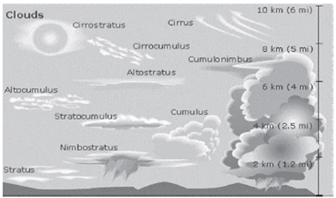
Precipitation
Precipitation, the process of moisture condensation in the atmosphere leading to the formation of water droplets or ice crystals that fall to the Earth’s surface, is a fundamental component of the water cycle.
- Rainfall: Rainfall, the most common form of precipitation, occurs when atmospheric moisture condenses into larger droplets that fall to the ground. Raindrops typically exceed 0.5 mm in diameter, distinguishing them from drizzle. Rainfall plays a crucial role in replenishing water sources and sustaining ecosystems.
- Snowfall: Snowfall occurs when water vapor directly converts into ice crystals at temperatures below freezing. These crystals accumulate to form snowflakes, which descend to the ground. Snowfall is prevalent in colder regions and during winter months, contributing to seasonal water storage and insulation of the Earth’s surface.
- Sleet: Sleet forms when rain passes through a layer of cold air near the Earth’s surface and freezes before reaching the ground. This results in the formation of small ice pellets or grains, which can create hazardous conditions on roadways and surfaces. Sleet is often associated with freezing rain events.
- Drizzle: Drizzle is characterized by light rainfall with very small water droplets, each less than 0.5 mm in diameter. Drizzle typically occurs in low-lying clouds or misty conditions and can persist for extended periods, albeit with relatively low intensity. It contributes to moisture distribution and ecosystem hydration.
- Hailstones: Hailstones form within strong thunderstorms characterized by intense convective currents. These currents carry water droplets to higher altitudes where temperatures are below freezing, causing the droplets to freeze and accumulate layers of ice. Eventually, the hailstones grow too heavy to remain aloft and fall to the ground, often causing damage to property and crops.
Differentiating Sleet and Hailstones
While both sleet and hailstones involve the freezing of precipitation, they differ in their formation and characteristics. Sleet originates as liquid rain that freezes upon contact with cold surfaces, resulting in the formation of small ice pellets. In contrast, hailstones form as solid pieces of ice within thunderstorm updrafts and fall to the ground as distinct, rounded masses.
RAINFALL AND ITS TYPES
Rainfall is a vital component of the Earth’s water cycle, crucial for sustaining life and ecosystems. It occurs when moisture-laden air cools and condenses, leading to the formation of water droplets that eventually fall to the ground. Understanding the types of rainfall and their origins is essential for various fields such as meteorology, agriculture, and hydrology.
Formation of Rainfall:
Rainfall is primarily a result of the condensation of water vapor in the atmosphere. When warm and moist air rises, it undergoes adiabatic cooling due to lower atmospheric pressure at higher altitudes. As the air cools, it reaches its dew point temperature, causing water vapor to condense into tiny water droplets. These droplets further combine and grow in size until they become heavy enough to fall as precipitation.
Pre-condition for Rainfall:
Several factors contribute to the formation of rainfall:
- Warm, Moist, and Unstable Air: Rainfall typically occurs in regions where warm, moisture-laden air is present. This air rises due to various mechanisms such as convection, frontal lifting, orographic lifting, or convergence, creating the conditions necessary for cloud formation and precipitation.
- Hygroscopic Nuclei: These are microscopic particles in the atmosphere around which water droplets can condense. An excess number of hygroscopic nuclei promotes the formation of cloud droplets, facilitating rainfall.
Types of Rainfall:
Convectional Rainfall
Convectional rainfall is a type of precipitation that occurs when the Earth’s surface becomes significantly heated, causing the air above it to rise rapidly, cool, and condense into clouds, eventually leading to rainfall. This type of rainfall is characterized by its association with convective clouds, such as cumulus and cumulonimbus, and is commonly observed in tropical regions and during warm, sunny seasons.
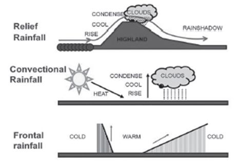
Stages of Convectional Rainfall:
Convectional rainfall typically involves four main stages:
- Insolation Heating: The process begins with the heating of the Earth’s surface by solar insolation (incoming solar radiation). As the sun’s rays strike the Earth’s surface, particularly in tropical areas, the surface temperature increases, making it hotter than its surroundings.
- Air Heating and Expansion: The heated surface warms the air in contact with it. This warm air becomes less dense and expands, becoming buoyant. As a result, it begins to rise vertically, creating a convective current.
- Condensation and Cloud Formation: As the warm air rises, it ascends into cooler layers of the atmosphere. As it moves upward, the air cools adiabatically (due to decreasing atmospheric pressure), reaching its dew point temperature. At this point, water vapor in the air condenses into tiny water droplets or ice crystals, forming cumulus clouds. The process of condensation continues as more moisture is added to the air, leading to the development of larger cumulonimbus clouds.
- Precipitation and Thunderstorms: Eventually, the cumulonimbus clouds reach a point where the water droplets become too heavy to remain suspended in the air, leading to precipitation in the form of rain. Convectional rainfall is often accompanied by thunder and lightning, particularly when intense updrafts and downdrafts within the cumulonimbus clouds generate electrical charges.
Characteristics of Convectional Rainfall:
- Heavy Precipitation: Convectional rainfall is characterized by intense and heavy downpours, often resulting in significant amounts of precipitation in a short period.
- Thunderstorms and Lightning: Thunderstorms are common during convectional rainfall events due to the rapid vertical movement of air within cumulonimbus clouds, leading to the formation of lightning.
- Short Duration: While intense, convectional rainfall tends to be brief and localized, typically lasting for a relatively short duration.
- Global Occurrence: Convectional rainfall is widespread and occurs in various parts of the world, particularly in tropical regions where solar heating is most intense.
- Associated Cloud Types: Convectional rainfall is primarily associated with convective clouds, such as cumulus and cumulonimbus, which exhibit rapid vertical development.
Regional Distribution: Convectional rainfall is commonly observed in tropical areas, particularly between the Tropic of Cancer and the Tropic of Capricorn. Additionally, regions with warm, sunny seasons, such as South East England, may experience convectional rainfall. In India, convectional rainfall occurs during the summer season before the onset of the Southwest monsoon. It is known by various regional names such as Mango showers (Karnataka, Kerala, Konkan, and Goa), Kal Baisakhi (West Bengal), and Bhardoli cheera (Assam), among others.
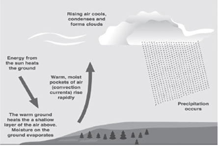
Orographic or Relief Rainfall
Orographic or relief rainfall is a type of precipitation that occurs when moist air is forced to ascend over elevated terrain such as mountains, hills, or other topographic features. This upward movement of air leads to cooling, condensation, and ultimately rainfall on the windward side of the mountain. The leeward side, however, experiences descending air, resulting in drier conditions known as the rain shadow zone.
Mechanisms of Orographic Rainfall:
The generation of orographic rainfall involves several key mechanisms:
- Obstruction of Moist Wind: When moist air from a body of water, such as the sea, encounters an elevated landmass like a mountain, it is forced to ascend due to the obstruction. This ascent can occur through various processes, including barrier winds or prevailing wind patterns.
- Adiabatic Cooling and Cloud Formation: As the moist air rises, it undergoes adiabatic cooling due to the decrease in atmospheric pressure with altitude. As the air cools, its capacity to hold moisture decreases, leading to the formation of clouds and eventually precipitation. This process occurs primarily on the windward side or slope of the mountain.
- Precipitation Distribution: The majority of precipitation occurs on the windward slopes of the mountain, where the air is forced to rise and cool. However, as the air descends on the leeward side, it warms adiabatically, increasing its ability to hold moisture. Consequently, the leeward slopes experience drier conditions and receive significantly less rainfall, creating a rain shadow zone.
Example: An example of orographic rainfall can be observed in the Western Ghats mountain range in India. The western slopes of the Western Ghats, such as Mahabaleshwar, receive substantial rainfall exceeding 600 cm annually due to the moist Arabian Sea winds encountering the mountain barrier. In contrast, the eastern slopes, such as Pune, experience much lower rainfall, around 70 cm annually, resulting in a rain shadow effect. The eastern slope of the Western Ghats serves as a rain shadow area due to the descending air and adiabatic warming.
Katabatic Wind: On the leeward side of the mountain, the descending air is warmed adiabatically as it descends and compresses due to increased atmospheric pressure at lower altitudes. This warm, dry wind is known as a katabatic wind. The katabatic wind contributes to the dry conditions on the leeward side of the mountain and plays a significant role in shaping local climates and ecosystems.

Cyclonic Rainfall (Frontal Rainfall)
Introduction: Cyclonic or frontal rainfall occurs when a warm air mass encounters a cold air mass, leading to the formation of a frontal boundary. As the warm, less dense air rises over the cooler, denser air, condensation occurs, resulting in the development of clouds and subsequent rainfall. Cyclonic rainfall is characterized by its gradual onset and can persist for several hours to days, particularly in regions where warm tropical air meets cold polar air masses.
Occurrence of Frontal Rainfall: The occurrence of frontal rainfall involves several key factors:
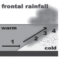
- Warm Air Meeting Cold Air: Frontal rainfall occurs when a warm air mass originating from tropical regions comes into contact with a cold air mass from polar regions. The temperature and density differences between these air masses create a frontal boundary.
- Forced Lifting of Warm Air: The warm, less dense air is forced to rise over the denser, colder air along the frontal boundary. As the warm air rises, it cools adiabatically, leading to condensation and the formation of clouds.
- Formation of Stratus Clouds: As the warm air continues to rise and cool, it reaches its dew point temperature, causing water vapor to condense into stratus clouds. These clouds are often associated with frontal systems and can extend over large areas.
- Precipitation: Once the stratus clouds become saturated with moisture, precipitation begins. Cyclonic rainfall typically falls gradually over a period of several hours to days, contributing to significant accumulations of rainfall in affected areas.
Regional Distribution: Frontal rainfall is prevalent in regions where warm oceanic air masses collide with cold continental air masses. One notable example is northwest Europe, where warm, moist air from the Atlantic Ocean interacts with cold air masses from continental Europe. This convergence of air masses leads to the formation of frontal boundaries and the development of heavy rainfall in adjacent areas. The persistent nature of frontal rainfall in northwest Europe can result in prolonged periods of wet weather and contribute to the region’s temperate climate.
World Distribution of Rainfall
The distribution of rainfall across the globe is a complex phenomenon influenced by various climatic factors and geographical features. Understanding the patterns of rainfall distribution is crucial for agriculture, water resource management, and overall ecosystem health.
Uneven Distribution:
Rainfall exhibits an uneven distribution worldwide, owing to diverse climatic conditions prevailing in different regions. Some areas experience abundant precipitation, while others suffer from arid conditions. This non-uniformity stems from factors such as proximity to water bodies, topography, and atmospheric circulation patterns.
Variations Throughout the Year and Across Seasons:
Distinct parts of the Earth receive varying quantities of rainfall throughout the year and across different seasons. This variability is influenced by factors like the tilt of the Earth’s axis, prevailing winds, and ocean currents. For instance, regions along the equator often experience consistent rainfall throughout the year, whereas temperate zones witness more pronounced seasonal variations.
Latitudinal Gradient:
In general, rainfall decreases significantly as one moves away from the equator towards the poles. The equatorial regions receive ample precipitation due to the convergence of warm, moist air masses, whereas polar regions experience comparatively drier conditions. This latitudinal gradient in rainfall distribution reflects the influence of solar radiation and atmospheric circulation patterns.
Coastal Influence:
Rainfall tends to be more abundant in coastal areas compared to inland regions. This is attributed to the proximity of coastal areas to oceans, which act as major moisture sources. Sea surfaces evaporate water, leading to the formation of clouds and subsequent precipitation over adjacent landmasses. Coastal regions thus benefit from a consistent supply of moisture, resulting in higher rainfall totals.
Effect of Prevailing Winds:
The distribution of rainfall is also influenced by prevailing wind patterns, such as the westerlies. In regions between 35° and 40° N and S of the equator, rainfall is greater on eastern coastlines and gradually decreases towards the west. Conversely, due to the westerlies, rainfall is initially received on the western borders of continents between 45° and 65° N and S of the equator, with a subsequent decrease towards the east.
Topographical Impact:
Topographical features, such as mountain ranges, play a significant role in modulating rainfall patterns. Rainfall is typically more abundant on the windward side of mountains, where moist air is forced to rise and cool, leading to condensation and precipitation. In contrast, the leeward side, or rain shadow, experiences reduced rainfall as descending air masses inhibit cloud formation and moisture retention.
World’s Principal Precipitation Regimes
Understanding the principal precipitation regimes across the world is crucial for comprehending the distribution of rainfall and its impact on various regions. These regimes delineate the patterns of precipitation, including annual totals and seasonal variations, providing insights into the climatic conditions prevailing in different geographical areas.
Equatorial Belt and Coastal Monsoon Lands:
The equatorial belt, encompassing regions near the equator, experiences abundant rainfall exceeding 200 cm annually. This high precipitation is attributed to the convergence of warm, moist air masses, resulting in frequent and intense rainfall throughout the year. Additionally, the windward slopes of mountains along the western shores of the cold temperate zone and the coastal sections of monsoon lands also receive over 200 cm of rainfall annually. These areas benefit from proximity to moisture-laden air masses and coastal influences, leading to persistent precipitation.
Interior Continental Areas:
Interior continental areas typically receive moderate rainfall ranging from 100 to 200 cm per annum. These regions are characterized by a lack of maritime influences and are located away from major moisture sources such as oceans. Despite receiving less rainfall compared to coastal regions, interior continental areas still experience moderate precipitation due to atmospheric circulation patterns and localized weather systems.
Central Parts of Tropical and Eastern/Interior Parts of Temperate Lands:
The central parts of tropical regions and the eastern and interior parts of temperate lands receive rainfall varying between 50 and 100 cm per annum. These areas exhibit a transition from humid to semi-arid climates, with precipitation influenced by seasonal variations in atmospheric circulation patterns. While these regions receive less rainfall compared to equatorial zones, they still support diverse ecosystems and agricultural activities dependent on seasonal rainfall.
Rain Shadow Zones and High Latitudes:
Areas lying in the rain shadow zone of the interior of continents and high latitudes receive very low rainfall, typically less than 50 cm per annum. Rain shadow zones are characterized by the blocking of moisture-laden air masses by mountain ranges, leading to reduced precipitation on the leeward side. Similarly, high latitudes experience limited precipitation due to their distance from moisture sources and the predominance of cold, dry air masses.
Seasonal Distribution:
The seasonal distribution of rainfall is an important aspect that influences its effectiveness in sustaining ecosystems and supporting human activities. In some regions, such as the equatorial belt and the western parts of cool temperate regions, rainfall is distributed evenly throughout the year. This consistent precipitation pattern ensures continuous water availability, fostering lush vegetation and agricultural productivity.
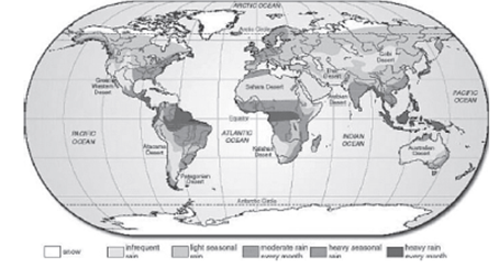
World Climate: Understanding Climate Classification and Factors Influencing Climate
Climate refers to the long-term average weather conditions in a particular region, typically spanning over 30 years or more. Various factors contribute to shaping the climate of a region, including latitude, elevation, proximity to water bodies such as lakes and rivers, ocean currents, topography, vegetation cover, and prevailing wind patterns.
Factors Influencing Climate:
- Latitude: Distance from the equator significantly affects temperature and sunlight intensity, influencing climate patterns.
- Elevation: Higher elevations generally experience cooler temperatures due to lower air pressure and thinner atmosphere.
- Proximity to Water Bodies: Oceans, lakes, and rivers moderate temperatures, leading to milder climates compared to inland regions.
- Ocean Currents: Warm or cold ocean currents can influence temperature and precipitation patterns along coastal areas.
- Topography: Mountain ranges can create rain shadows, affecting precipitation patterns on the leeward side.
- Vegetation: Vegetation not only responds to climate but also plays a role in shaping it by influencing factors such as evapotranspiration and albedo.
- Prevailing Winds: Wind patterns affect temperature, humidity, and precipitation distribution across regions.
Classification of World Climate:
- The Hot, Wet Equatorial Climate: Characterized by high temperatures and heavy rainfall throughout the year, typically found near the equator.
- The Tropical Monsoon and Tropical Marine Climates: Experiencing distinct wet and dry seasons, common in regions influenced by monsoonal patterns.
- The Savanna or Sudan Climate: Features distinct wet and dry seasons with moderate to high temperatures and sparse vegetation.
- The Hot Desert and Mid-Latitude Desert Climates: Extremely arid regions with minimal rainfall and high temperatures.
- The Warm Temperate Western Margin (Mediterranean) Climate: Mild, wet winters and hot, dry summers, common in regions bordering the Mediterranean Sea.
- The Temperate Continental (Steppe) Climate: Characterized by hot summers, cold winters, and low precipitation, typical of interior continents.
- The Warm Temperate Eastern Margin (China Type) Climate: Experiences distinct seasons with hot, humid summers and cold, dry winters, prevalent in eastern Asia.
- The Cool Temperate Western Margin (British Type) Climate: Mild, wet winters and cool, moist summers, typical of coastal regions influenced by oceanic climates.
- The Cool Temperate Continental (Siberian) Climate: Harsh winters with moderate precipitation and short, mild summers, common in inland areas of Siberia.
- The Cool Temperate Eastern Margin (Laurentian) Climate: Cold winters, warm summers, and moderate precipitation, characteristic of eastern North America.
- The Arctic or Polar Climate: Extreme cold temperatures, low precipitation, and long winters, predominant in polar regions near the North and South Poles.
Köppen Climate Classification:
The Köppen climate classification system, developed by German climatologist and plant geographer V. Köppen in 1918, is one of the most widely used schemes for classifying climates. Köppen’s classification is based on annual and monthly averages of temperature and precipitation, as well as the distribution of weather conditions. He also correlated his climate types with global vegetation zones, recognizing a close relationship between climate and vegetation distribution. By analyzing annual temperature and precipitation averages, Köppen delineated climate regions across the world, providing a systematic framework for understanding and studying global climate patterns.
Features of Köppen Climate Classification:
Vladimir Köppen introduced a comprehensive system for classifying climates worldwide, which remains widely utilized due to its simplicity and effectiveness. The Köppen climate classification system categorizes climates based on temperature and precipitation patterns, utilizing a combination of capital and small letters to designate climatic groups and types.
Main Climate Types:
Group A: Tropical Climates
These climates are characterized by high temperatures throughout the year and abundant precipitation.
Subdivided into:
- Af: Tropical Rainforest Climate
- Am: Tropical Monsoon Climate
Group B: Dry Climates
These climates experience minimal precipitation, resulting in arid or semi-arid conditions.
Subdivided into:
BW: Desert Climate
BS: Steppe Climate
Group C: Mild Temperate Climates
These climates have moderate temperatures with relatively even distribution of precipitation throughout the year.
Subdivided into:
Cfa: Humid Subtropical Climate
Cfb: Marine West Coast Climate
Cfc: Mediterranean Climate
Group D: Continental Climates
These climates exhibit significant temperature variations between seasons, with relatively moderate precipitation.
Subdivided into:
Dfa: Hot Summer Continental Climate
Dfb: Warm Summer Continental Climate
Dfc: Subarctic Climate
Group E: Polar Climates
These climates are characterized by extremely cold temperatures and minimal precipitation.
Subdivided into:
ET: Tundra Climate
EF: Ice Cap Climate
Additional Features:
- Letter ‘H’ for Highland Climates: Köppen introduced the letter ‘H’ to designate highland or mountainous climates, which exhibit distinct temperature and precipitation patterns due to elevation.
- Capital vs. Small Letters: Capital letters (A, C, D, E) represent humid climates, while the letter ‘B’ denotes dry climates. The use of small letters further subdivides each main climate type based on temperature and precipitation variations.
| Sr. No. | Chief Climatic Groups | Characteristics | Climatic Types |
| 1 | Tropical Climate | Average temperature of the coldest month is 18°C or higher
Dominated by lush tropical rainforests May exhibit Savannah or Monsoon patterns |
Tropical Rainforest Climate (Af)
Savannah Climate (Aw) Monsoon Climate (Am) |
| 2 | Dry Climate | Potential evaporation exceeds precipitation
Sparse vegetation and arid landscapes |
Desert Climate (BW)
Steppe (Semi-desert) Climate (BS) |
| 3 | Temperate Climate | Average temperature of the coldest month ranges from -3°C to 18°C
Moderate temperatures with distinct seasons |
Mediterranean Climate (C)
China Type Climate (Cw) West European Type Climate (Cfb) |
| 4 | Continental Climate | Average temperature of the coldest month is below -3°C
Pronounced temperature variations between seasons |
Taiga Climate (D)
Eastern Coastal Cold Climate (Dwc) Continental Climate (Dfa) |
| 5 | Polar Climate | Average temperature for all months is below 10°C
Extreme cold temperatures with permanent ice cover |
Tundra Climate (ET)
Snow-capped Region Type Climate (EF) |
| 6 | Highland Climate | Cold temperatures due to elevation | Various highland climates characterized by elevation (e.g., H) |
Comparative Chart for the World Climate
| Latitude | Western Margin | Continental Margin | Eastern Margin |
| 65°C to 90°C NH | Tundra Type | Boreal/Siberian Type | Laurentian Type |
| 45°C to 65°C NH | Cool Temperate: British Type | Boreal/Siberian Type | Laurentian Type |
| 30°C to 45°C NH | Warm Temperate: Mediterranean Type | Steppe Type | China Type |
| 10°C to 30°C NH | Desert Type | Savannah Type | Monsoon Type |
| 0°C to 10°C NH | Equatorial Type of Climate | Equatorial Type of Climate | Equatorial Type of Climate |
| 0°C to 10°C SH | Equatorial Type of Climate | Equatorial Type of Climate | Equatorial Type of Climate |
| 10°C to 30°C SH | Desert Type | Savannah Type | Monsoon Type |
| 30°C to 45°C SH | Warm Temperate: Mediterranean Type | Steppe Type | China Type |
| 45°C to 65°C SH | Cool Temperate: British Type | Boreal/Siberian Type | Laurentian Type |
| 65°C to 90°C SH | Tundra Type | Boreal/Siberian Type | Laurentian Type |
Characteristics of Climate Types:
Tundra Type:
Very low precipitation
Lack of vegetation
Chilly rainy winter & warm rainy summer
Cool Temperate: British Type:
Throughout precipitation
Summer rainfall
Long winter & pleasant summer
Warm Temperate: Mediterranean Type:
Throughout precipitation due to ocean current & temperate cyclone influence
Winter rainfall
Dry summer & cool wet winter
Desert Type:
Very low precipitation
Influence of easterly & tropical cyclones
No winter precipitation
Boreal/Siberian Type:
Throughout precipitation
No winter precipitation
Lack of diversity of flora and fauna
Laurentian Type:
Summer rainfall
Alternate dry and wet seasons
Seasonal variation of winds
Steppe Type:
Throughout precipitation
No winter precipitation
China Type:
Throughout precipitation
No winter precipitation
Savannah Type:
Summer rainfall
Seasonal variation of winds
Monsoon Type:
Summer rainfall
Seasonal variation of winds
Equatorial Type of Climate:
Throughout precipitation
No winter precipitation
Hot, Wet Equatorial Climate (Koeppen’s Classification)
| Aspect | Description |
| Location | Found between 5° and 10° north and south of the equator. |
| Regions include lowlands of the Amazon, the Congo, Malaysia, and the East Indies. | |
| Temperature | Uniform temperature throughout the year. |
| Mean monthly temperature ranges from 24°C to 27°C. | |
| No distinct winter season. | |
| Precipitation | Heavy and evenly distributed precipitation throughout the year. |
| Annual average precipitation always exceeds 150 cm. | |
| High evaporation rates and convection air currents lead to heavy afternoon thunderstorms. | |
| Natural Vegetation | High temperatures and abundant rainfall support the growth of a lush tropical rainforest. |
| The dense forest of the Amazon is known as Selvas. | |
| Comprises a multitude of evergreen trees, including tropical hardwoods like mahogany and ebony. | |
| Mangrove forests thrive in coastal areas and brackish swamps. | |
| Economy & Development | Inhabited by various tribes such as Indian tribes of the Amazon basin, Pygmies of the Congo basin, and Orang Asli of Malaysia. |
| Plantation crops like rubber and cocoa are cultivated. | |
| Primitive tribes often practice hunting and gathering, while more advanced groups engage in shifting cultivation in the forests. |

Tropical Monsoon and Tropical Marine Climates
1. Introduction:
- Tropical monsoon and tropical marine climates are two distinct climate types characterized by specific patterns of precipitation, influenced largely by seasonal winds.
2. Tropical Monsoon Climate:
- Description: This climate type is characterized by distinct wet and dry seasons, with heavy rainfall during the wet season and significantly reduced precipitation in the dry season.
- Seasonal Winds: Seasonal winds, known as monsoons, play a significant role. During the summer, onshore winds bring moisture from the ocean, resulting in heavy rainfall (wet monsoon). In the winter, offshore winds prevail, leading to drier conditions (dry monsoon).
- Geographical Distribution: Predominantly found in regions such as the Indian subcontinent, Burma, Thailand, Laos, Cambodia, parts of Vietnam, south China, and northern Australia.
- Climate Conditions: The wet monsoon season is characterized by high humidity, warm temperatures, and frequent rainfall, while the dry monsoon season experiences lower humidity and temperatures.
- Impacts: Agriculture and ecosystems in these regions are heavily reliant on the seasonal rainfall patterns. The wet season allows for agricultural activities, while the dry season may lead to water scarcity and droughts.
3. Tropical Marine Climate:
- Description: Unlike the distinct wet and dry seasons of the tropical monsoon climate, the tropical marine climate experiences more evenly distributed rainfall throughout the year.
- Influence of Trade Winds: Outside the tropical monsoon zone, the climate is influenced by the onshore Trade Winds, which bring moisture consistently throughout the year.
- Geographical Distribution: Commonly found in regions such as Central America, the West Indies, northeastern Australia, the Philippines, parts of East Africa, Madagascar, the Guinea Coast, and eastern Brazil.
- Climate Conditions: This climate type typically experiences warm temperatures year-round, with moderate to high humidity levels. Rainfall occurs more consistently across the year compared to the tropical monsoon climate.
- Impacts: The more consistent rainfall patterns support diverse ecosystems and agricultural activities throughout the year, although variations in precipitation can still impact local economies and environments.
Climatic Conditions in Tropical Monsoon Lands
| Climatic Conditions in Tropical Monsoon Lands | Summer Seasons | Winter Season |
| Root Cause of Monsoon Climates | The difference in the rate of heating and cooling of land and sea. During summer, when the sun is overhead at the Tropic of Cancer, the northern hemisphere’s land masses, including Central Asia, become significantly hotter than the seas. This temperature contrast leads to the formation of intense low pressure over Central Asia and high pressure in the continental interior of Australia. | In winter, when the sun is overhead at the Tropic of Capricorn, Central Asia becomes extremely cold, resulting in rapid cooling of the land. This creates a region of high pressure. Winds blow outwards as the North-East Monsoon. Upon crossing the equator, these winds are attracted to the low-pressure center in Australia, arriving in northern Australia as the North-West Monsoon. |
| Summer Season Dynamics | Central Asia experiences intense heating, leading to a significant temperature difference between land and sea. – Low pressure develops over Central Asia, while high pressure occurs in the continental interior of Australia. – Winds blow outwards as the South-East Monsoon, cross the equator, and are drawn towards the low-pressure area, reaching the Indian subcontinent as the South-West Monsoon. | Central Asia experiences extreme cold, resulting in rapid land cooling. – High pressure is created, leading to the North-East Monsoon blowing winds. – Upon crossing the equator, winds are attracted to the low-pressure center in Australia, arriving in northern Australia as the North-West Monsoon. |
| Rainfall Patterns | Heavy rainfall occurs during the wet monsoon season, characterized by the South-West Monsoon. – The amount and frequency of rain decrease towards the end of the rainy season, gradually retreating southwards after mid-September. – The dry season returns in October, marked by the out-blowing North-East Monsoon. | Rainfall decreases significantly during the dry monsoon season, which is marked by the North-East Monsoon. – The withdrawal of the monsoon gradually occurs, starting from the northern regions and progressing southwards. The dry season, with clear skies and cool temperatures, persists until the onset of the next wet monsoon season. |
| Impact on Agriculture and Economy | Monsoons play a vital role in agriculture and the economy. – Late or early monsoons can lead to drought or flood conditions, respectively, affecting crop yields and causing famine. – Severe floods from heavy monsoon rains can destroy crops, infrastructure, and lives, disrupting communications and livelihoods. | Monsoons are critical for agricultural activities. – Late or early monsoons can have devastating effects on crops and the economy, leading to famine or widespread destruction from floods. – The economy of regions reliant on monsoon rains is deeply influenced by their timing and intensity. |
Tropical Monsoon Forests
Tropical monsoon forests are a type of natural vegetation found in regions characterized by distinct wet and dry seasons, with heavy rainfall during the summer monsoon period. These forests exhibit deciduous characteristics, shedding their leaves during the dry season to conserve water. The composition and density of these forests vary based on the amount of rainfall received, with more rainfall leading to denser vegetation.
Characteristics:
- Deciduous Nature: Trees in tropical monsoon forests are deciduous, shedding their leaves during the dry season to conserve water and withstand drought conditions.
- Vegetation Density: These forests are less dense compared to equatorial rainforests, with a lower species diversity.
- Timber Resources: Many of the trees in tropical monsoon forests yield valuable timber, prized for their durable hardwood. Teak, found predominantly in Burma, is a notable example, contributing significantly to global timber production.
- Transition into Savanna: In areas where summer rainfall decreases, the forests transition into thorny scrubland or savanna, characterized by scattered trees and tall grass. In extreme cases, semi-desert conditions may prevail, especially in parts of the Indian subcontinent with deficient rainfall.
Tropical Marine Climate
The tropical marine climate is predominant along the eastern coasts of tropical regions, where steady rainfall occurs due to the influence of Trade Winds. This climate is characterized by orographic and convectional rainfall patterns, making it conducive to habitation but prone to severe tropical cyclones, hurricanes, or typhoons.
Characteristics:
- Rainfall Patterns: Rainfall in tropical marine climates is influenced by both orographic factors, where moist Trade Winds meet upland masses, and convectional factors, driven by intense heating during the day and summer months. The wettest months typically occur during the southern hemisphere’s summer (January-April), with approximately 70% of the annual rainfall falling during these months.
- Favorable Habitation: Despite the risk of tropical cyclones, the steady influence of Trade Winds makes the tropical marine climate more favorable for habitation compared to other climate types.
Crops
Overview: Agriculture in tropical monsoon regions is heavily dependent on irrigation due to the seasonal nature of rainfall. Rice is the primary staple crop, extensively cultivated using irrigation water from rivers, canals, dams, or wells. Additionally, other food crops such as maize, millet, sorghum, wheat, gram, and beans are grown in drier or cooler areas where rice cultivation is not feasible.
Key Points:
- Rice Cultivation: Rice is the most important staple crop in tropical monsoon regions, with extensive irrigation infrastructure supporting its cultivation.
- Irrigation Practices: Irrigation plays a crucial role in agriculture, with water sourced from various natural and artificial sources to support crop growth, particularly rice.
- Secondary Food Crops: Other food crops like maize, millet, sorghum, wheat, gram, and beans are cultivated in areas with less suitable conditions for rice cultivation, contributing to food security and dietary diversity in the region.
Overall, tropical monsoon regions exhibit unique ecological and climatic characteristics that influence vegetation patterns, agricultural practices, and human habitation. Understanding these dynamics is essential for sustainable resource management and agricultural development in these regions.
| Category | Crop | Details |
| Lowland Cash Crops | Cane Sugar | Primary crop in lowland areas
About two-thirds of global sugar production is from tropical countries Major producers: India, Java, Formosa, Cuba, Jamaica, Trinidad, Barbados |
| Jute | Predominantly grown in the Ganges-Brahmaputra delta
Mainly cultivated in India and Bangladesh |
|
| Cotton | Significant commercial crop in the Indian subcontinent | |
| Highland Plantation | Tea | European colonization led to plantation agriculture in cooler monsoonal highlands
Tea is a key crop |
| Crops | Coffee | Cultivation of coffee alongside tea in the highland plantations |
Lumbering
Overview: Lumbering refers to the process of harvesting timber from forests for commercial purposes. In tropical regions, where forests yield valuable hardwood, lumbering plays a significant role in the economy. Accessible areas are targeted for lumbering activities, particularly in continental South-East Asia, where forests are abundant.
Characteristics:
- Valuable Timber Resources: Tropical forests often contain valuable hardwood species that are highly sought after for their durability, strength, and resistance to various natural threats. Teak, particularly abundant in Myanmar, stands out as one of the most prized timber species due to its exceptional qualities, including immunity to shrinkage, fungus attack, and insects.
- Timber Diversity: Apart from teak, tropical deciduous trees offer a diverse range of timber resources. Species such as Neem, Banyan, Mango, Sal, Acacia, and Eucalyptus contribute to the lumbering industry, each with its unique properties and uses.
- Accessibility and Importance: Lumbering operations tend to focus on accessible areas to minimize logistical challenges and costs. Continental South-East Asia, with its extensive forest cover, becomes a focal point for lumbering activities due to the abundance of valuable timber resources.
Economy of Tribesmen
Indigenous tribes in tropical regions often rely on primitive forms of farming for subsistence. Their agricultural practices, heavily reliant on shifting cultivation, reflect a deep connection with the land and a traditional lifestyle.
Characteristics:
- Primitive Farming Practices: Tribesmen engage in primitive forms of farming, often characterized by shifting cultivation. Instead of rotating crops to preserve soil fertility, they clear forest land for cultivation when their existing fields become exhausted. This practice reflects a sustainable approach to farming within the context of traditional knowledge and resource management.
- Subsistence Agriculture: Farming activities among tribesmen are primarily for subsistence purposes. The produce grown is consumed by the farmer’s family and is not traded or sold in commercial markets. This highlights the self-sufficiency and self-reliance of indigenous communities in meeting their basic needs through agriculture.
- Challenges of Tropical Soils: Tropical soils are prone to rapid leaching and depletion of nutrients, posing challenges for sustainable agriculture. While the initial harvest from cleared forest land may be bountiful, subsequent crops often suffer from deteriorating soil quality, leading to diminishing yields over time.
- Widespread Shifting Cultivation: Shifting cultivation, practiced extensively among indigenous tribes, is characterized by the rotation of cultivation sites and the use of different local names in various countries. This traditional farming method reflects a deep understanding of the local ecosystem and the need for sustainable land use practices to support livelihoods in tropical regions.
Understanding the interplay between lumbering practices and the traditional economy of tribesmen sheds light on the complex dynamics of resource utilization, sustainability, and cultural heritage in tropical regions. Balancing economic development with environmental conservation and respecting indigenous knowledge is crucial for ensuring the long-term well-being of both forests and communities in these areas.
| Region | Shifting Cultivation |
| Malaysia | Lacking |
| Burma | Taungya |
| Thailand | Tamrai |
| Philippines | Caingin |
| Sri Lanka | Chena |
| North-east India | Jhum |
| Java | Humah |
| Africa and Central America | Milpa |
The Savanna or Sudan Climate
The Savanna climate, also known as the Sudan Climate, is a transitional climate zone found between Equatorial rainforests and trade wind hot deserts. It is characterized by distinct wet and dry seasons, with moderate to high temperatures throughout the year. Savannas thrive in tropical climates ranging from approximately 8 to 20 degrees north and south of the Equator. This climate type is best developed in Sudan, hence its alternative name.
Regions with Similar Climate: Savanna climates can be found in various parts of the world including Africa, South America, Australia, India, Myanmar, Thailand, and Madagascar.
Variants of Savanna Climate
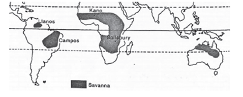
| Type | Description | Regions |
| African Savanna | Extends from West African Sudan, curves southwards into East Africa, and southern Africa up to north of the Tropic of Capricorn. | West Africa, East Africa, Southern Africa |
| South American Savanna | Comprises two regions: one north of the Equator known as llanos of the Orinoco basin, and another south of the Equator consisting of the Brazilian Highlands. | Orinoco Basin, Brazilian Highlands |
| Australian Savanna | Located south of the monsoon strip, spanning from northern Australia (west of the Tropic of Capricorn) to the eastern regions. | Northern Australia |
| Indian Savanna | Exhibited in regions of Northern Karnataka, Southern Maharashtra, and Telangana. | Northern Karnataka, Southern Maharashtra, Telangana |
Characteristics of Savanna Climate
- Temperature: Generally warm to hot year-round with little seasonal variation.
- Rainfall: Exhibits distinct wet and dry seasons. Rainfall is seasonal, with most precipitation occurring during the wet season.
- Vegetation: Savannas are characterized by a mix of grasslands and scattered trees. The vegetation is adapted to the seasonal rainfall pattern.
- Wildlife: Rich biodiversity with a variety of large mammals, birds, and reptiles adapted to the savanna environment.
- Human Activity: Savannas support agriculture, pastoralism, and other economic activities. Human populations in these regions often practice subsistence farming or traditional livelihoods.
- Climate Change Impact: Vulnerable to climate change, particularly changes in rainfall patterns and increased frequency of extreme weather events.
Climate
| Aspect | Details |
| Climate | Alternates between dry and wet seasons. Onshore winds bring rains in summer, while offshore winds keep the climate dry in winter. |
| Rainfall | Average Annual Rainfall: 80 to 160 cm
Rainy Season: May to September (Northern Hemisphere), October to March (Southern Hemisphere) |
| Temperature | – Mean Annual Temperature: >18°C
Highest Temperature: Just before the onset of the rainy season (April in Northern Hemisphere, October in Southern Hemisphere) Monthly Temperature Range: 20°C to 32°C <br>- Extreme Diurnal Temperature Range: Hot days and cold nights. |
| Winds | Trade winds prevalent in the region.
Strongest in summer due to the Intertropical Convergence Zone (ITCZ), bringing rain to coastal regions. Become relatively dry inland. Easterlies, leading to reduced rainfall from east to west. In West Africa, North-East Trade winds blow off-shore from the Sahara Desert towards the Guinea coast, bringing dry, dust-laden winds. |
Vegetation of Savannah
The vegetation of the savanna landscape is distinctive, characterized by tall grasses and scattered low trees. This ecosystem is often referred to as ‘bush-veld.’:
- Grasslands: Dominated by tallgrass, with some areas featuring coarse grasses reaching heights of 6 to 12 feet. Elephant grass, a common species, can grow even taller, up to 15 feet. During the rainy season, grasses appear lush and green, but they turn yellow and die off as the dry season approaches.
- Deciduous Trees: Trees in the savanna are mostly deciduous, shedding their leaves during the cold, dry season to minimize water loss through transpiration. These trees often have broad trunks with specialized water-storing systems to survive prolonged droughts. Many trees have umbrella-shaped canopies, exposing only a thin edge to powerful winds.
- Transition to Thorny Shrubs: As rainfall decreases closer to desert regions, the savanna transitions into areas dominated by thorny shrubs. These shrubs are adapted to arid conditions and often have small leaves and thorns to reduce water loss and deter herbivores.
The savanna vegetation is adapted to the alternating wet and dry seasons, showcasing a diverse array of plant species that thrive in this unique environment.
Wildlife of Savannah
The savanna is renowned as ‘big game country’ due to its rich and diverse wildlife.:
- Herbivores: The savanna supports a vast array of herbivorous species, including zebras, antelopes, giraffes, deer, gazelles, and elephants. These animals graze on the abundant grasses and browse on low-lying vegetation, sustaining large populations throughout the savanna regions.
- Carnivores: Predatory animals in the savanna include lions, tigers, leopards, hyenas, panthers, jaguars, and jackals. They play a crucial role in regulating herbivore populations and maintaining ecosystem balance.
- Reptiles and Aquatic Mammals: The savanna is also home to a variety of reptiles, including crocodiles, alligators, and giant lizards, which inhabit rivers and marshy lakes. Additionally, species like rhinoceroses and hippopotamuses are found near water sources, coexisting with other wildlife in these habitats.
Overall, the savanna supports a complex and interconnected web of life, with diverse species coexisting and relying on each other for survival. This rich biodiversity makes the savanna a prime location for wildlife enthusiasts and conservation efforts alike.
Life and Economy in Savannah Regions
Savannah regions harbor unique lifestyles and economic activities shaped by the environment’s characteristics and the cultures of indigenous tribes. Here’s an in-depth exploration:
Tribes:
Masai Tribes:
Location: Reside in the East African plateau.
Livelihood: Primarily pastoralists, known for their cattle herding traditions.
Hausa:
Location: Northern Nigeria.
Livelihood: Engaged in settled cultivation, clearing land for agriculture and utilizing it for several years.
Cultivation:
- Challenges: Savannah regions experience intermittent rainfall, leading to prolonged droughts. During the rainy season, heavy precipitation causes leaching of nutrients like nitrate, phosphate, and potash. Most water evaporates in the dry season due to excessive warmth, leaving behind poor lateritic soils unsuitable for robust crop growth.
Cattle Rearing:
- Natural Cattle Country: The savanna is well-suited for cattle rearing, attracting pastoralist communities like the Masai tribes.
- Challenges: Grasses in savannas are less nutritious compared to temperate grasslands, resulting in poor-quality cattle breeds yielding minimal meat or milk.
- Technological Advancements: Some savanna regions, like Queensland in Australia, have embraced science and technology to advance cattle rearing. Queensland has become a leading cattle producer, exporting both meat and milk.
Crops:
- Agricultural Potential: Central Africa, northern Australia, and eastern Brazil possess vast agricultural potential.
- Cotton Production: Countries like Kenya, Uganda, Tanzania, and Malawi have initiated large-scale cotton production.
- Oil Palm, Cocoa, and Groundnuts: West Africa has taken significant strides in commercial cultivation of crops like oil palm, cocoa, and groundnuts, leading to economic growth and export opportunities.
Savannah regions showcase a blend of traditional practices and modern advancements, adapting to the unique challenges and opportunities presented by the environment. Despite challenges such as erratic rainfall and poor soil quality, innovative approaches and cultural traditions contribute to the resilience and prosperity of communities in these regions.
Desert Climates: Hot Deserts vs. Mid-Latitude Deserts
Deserts, characterized by arid conditions where evaporation surpasses precipitation, represent some of the most extreme environments on Earth. Broadly categorized into hot deserts and mid-latitude deserts, these regions exhibit distinct climatic features and geographical distributions.
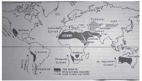
I. Hot Deserts:
Characteristics:
- Hot deserts, also referred to as Trade Wind Deserts, derive their aridity primarily from offshore Trade Winds.
- These deserts experience high temperatures and minimal rainfall, resulting in parched landscapes and sparse vegetation.
Geographical Distribution:
- Hot deserts are predominantly located along the western coasts of continents within latitudes 15° to 30° north and south of the equator.
- Examples include:
- Asia: Sahara Desert (spanning 3.5 million square miles), Great Australian Desert, Arabian Desert, Iranian Desert, Thar Desert, Kalahari Desert, and Namib Desert.
- North America: Mojave Desert, Sonoran Desert, California Desert, and Mexican Desert.
- South America: Atacama or Peruvian Desert, renowned for its extreme aridity, receiving less than 2 cm of precipitation annually, attributed to the rain shadow effect and offshore trade winds.
Key Factors Contributing to Aridity:
- Trade Winds: The prevailing offshore Trade Winds play a pivotal role in shaping the arid conditions of hot deserts, carrying moisture away from the landmasses and limiting precipitation.
- Rain Shadow Effect: Mountain ranges situated parallel to the coastlines obstruct moisture-laden air masses, causing precipitation to be deposited on windward slopes, leaving leeward regions arid and desert-like.
Climate Adaptations:
- Flora and fauna in hot deserts have evolved unique adaptations to survive in harsh conditions characterized by scorching temperatures, limited water availability, and infrequent rainfall.
- Examples of adaptations include deep root systems, water-conserving mechanisms, nocturnal activity patterns, and heat-resistant physiological traits.
II. Mid-Latitude Deserts:
Characteristics:
- Mid-latitude deserts exhibit climatic conditions distinct from hot deserts, characterized by moderate temperatures and lower aridity compared to their equatorial counterparts.
- These deserts experience greater temperature fluctuations between day and night, with winters often being cooler than those in hot deserts.
Geographical Distribution:
- Mid-latitude deserts are typically located within the interior regions of continents, far from maritime influences, often encompassing areas of high pressure and descending air masses.
- Examples include: Gobi Desert in Asia, Patagonian Desert in South America, and Great Basin Desert in North America.
Key Factors Contributing to Aridity:
- Rain Shadow Effect: Similar to hot deserts, mid-latitude deserts can be influenced by rain shadow effects caused by mountain ranges, leading to reduced precipitation in leeward regions.
- Subtropical High-Pressure Belts: These deserts often lie within regions influenced by subtropical high-pressure systems, where descending air masses inhibit cloud formation and precipitation.
Climate Adaptations:
- Flora and fauna in mid-latitude deserts have also evolved specific adaptations to cope with arid conditions, albeit in a different climatic context compared to hot deserts.
- Adaptations may include drought-resistant foliage, specialized water storage organs, and behavioral strategies to minimize water loss.
Mid-Latitude Deserts: A Detailed Overview
Mid-latitude deserts are regions characterized by extreme aridity, situated between 30 and 60 degrees north and south of the equator. Unlike hot deserts located nearer to the tropics, mid-latitude deserts are positioned within the interiors of continents, far from maritime influences.
I. Geographical Distribution:
1. Regions:
- Asia: Notable mid-latitude deserts include the Gobi Desert and the north-western Taklamakan Desert, spanning areas of China, Kazakhstan, and Uzbekistan.
- North America: Portions of the Great Basin Desert in the western United States exhibit mid-latitude desert conditions.
- South America: The Patagonian Deserts of Argentina are prominent examples, situated on the leeward side of the towering Andes mountains, experiencing rain shadow effects.
II. Precipitation Patterns:
1. Aridity:
- Mid-latitude deserts are characterized by arid environments where total annual precipitation is less than half of the yearly potential evapotranspiration.
- Precipitation is scarce due to the absence of nearby moisture sources and the rain shadow effect caused by mountain ranges.
- Unlike tropical deserts, where rainfall is sporadic and infrequent, mid-latitude deserts may receive more precipitation, particularly during winter months due to cyclonic activity.
III. Vegetation:
1. Adaptations:
- Vegetation in mid-latitude deserts is predominantly xerophytic, featuring plants adapted to drought conditions.
- Examples of vegetation include cacti, prickly shrubs, long-rooted wiry grasses, and scattered dwarf acacias.
- Trees are sparse, with date palms being an exception in some areas.
- Excessive evaporation leads to soil salinity, forming hardpans as dissolved salts concentrate on the surface.
- Due to limited precipitation, decomposition processes are slow, resulting in soils low in humus content.
- Plants have evolved mechanisms to cope with water scarcity, such as deep root systems to access groundwater and foliage adaptations to reduce water loss.
- Foliage characteristics include waxy, leathery, hairy, or needle-shaped leaves, aimed at minimizing transpiration.
Desert Climates
1. Overview:
Desert climates, whether hot deserts or mid-latitude deserts, are characterized by extremely low levels of precipitation. This scarcity of rainfall profoundly influences the ecosystems and landforms of these regions.
2. Annual Precipitation:
Hot Deserts: Typically receive less than 25 cm of annual precipitation. The Atacama Desert in South America stands out as one of the driest places on Earth, receiving minimal to no rainfall.
Mid-Latitude Deserts: Share similar precipitation levels, generally less than 25 cm annually. While they may receive slightly more precipitation than hot deserts due to their location, it remains significantly low.
3. Nature of Rainfall:
Hot Deserts: When rainfall does occur, it often takes the form of intense convectional rainfall. These rains are sporadic and irregular, often accompanied by violent thunderstorms. The sudden deluge can lead to flash floods, which pose severe risks to desert ecosystems and landforms. Flash floods erode soils, carve canyons, and reshape landscapes in a matter of minutes, leaving behind drastic changes.
Mid-Latitude Deserts: Experience similar patterns of convectional rainfall, although possibly less frequent and intense compared to hot deserts. However, when rainfall does occur, it still carries the potential for flash floods and their associated impacts on the desert environment.
4. Impact on Desert Landforms:
Hot Deserts: Flash floods triggered by sudden, intense rainfall events have significant consequences on desert landforms. These floods can carve out channels and arroyos, altering the landscape dramatically. They also deposit sediment, forming alluvial fans and deltas. Over time, these processes contribute to the unique topography of hot desert regions.
Mid-Latitude Deserts: Similarly, flash floods play a role in shaping landforms in mid-latitude deserts. Though possibly less frequent, they still contribute to erosion and sediment deposition, influencing the evolution of desert landscapes.
5. Adaptations of Desert Flora and Fauna:
Desert plants and animals have evolved various adaptations to cope with the sporadic and unpredictable nature of desert rainfall. Some plants have deep root systems to quickly absorb water during rare rainfall events, while others have developed mechanisms to store water for extended periods.
Animal species often exhibit behaviors such as burrowing underground or entering a state of dormancy during dry periods, emerging to take advantage of brief periods of moisture.
6. Human Impacts and Adaptations:
Human settlements in desert regions must contend with the challenges posed by limited water resources and the risk of flash floods. Infrastructure, agriculture, and urban planning in desert areas often incorporate strategies to mitigate these risks, such as water conservation measures and flood control systems.
Temperature:
| Aspect | Hot Deserts | Mid-Latitude Deserts |
| Average Temperature | More than 30°C | High yearly temperature compared to tropical deserts |
| Cold Season | No cold season | Absence of a distinct cold season |
| Reasons for Temperature Extremes | – Cloudless sky – Intense insolation – Dry air – Rapid evaporation | – Dominant high pressure – Lack of moisture – Clear days and nights |
| Diurnal Temperature Range | Large diurnal temperature range due to: | Substantial daily temperature fluctuations due to: |
| – Intense insolation | – Clear days and nights | |
| – Dry air | ||
| – No clouds | ||
| Coastal vs. Interior Deserts | Coastal deserts have lower temperatures due to cooling effect of cold currents | Interior deserts experience higher summer temperatures and colder winters |
| Interior deserts experience higher summer temperatures and colder winters |
The Warm Temperate Western Margin (Mediterranean) Climate
Location:
- Located between 30° and 45° north and south of the latitude.
- Central Chile is the most prominent region exhibiting this climate type. Other notable regions include the southwestern tip of Africa (around Cape Town), Southern Australia, and southwest Australia.
Characteristics:
Seasonal Variation:
Mediterranean climate is characterized by distinct seasonal variations, with hot, dry summers and cool, wet winters.
This pattern is particularly pronounced on the western sides of continents within the specified latitudinal range (3° to 45° latitude).
Precipitation:
Average annual precipitation in Mediterranean climates typically ranges from 350 to 900 mm.
The majority of this rainfall occurs during the cooler winter months, while summers are generally dry.
Wind Patterns:
Around the Mediterranean Sea, specific winds such as the Sirocco and Mistral are commonly experienced.
The Sirocco is a hot, dry, dusty wind originating from the Sahara Desert, while the Mistral is a strong, cold northwesterly wind that sweeps down from the Alps.
Vegetation:
- Mediterranean landscapes host unique vegetation adapted to the climate’s challenges.
- Vegetation in these regions typically includes:
- Small Size Trees: Trees with small stature and broad leaves are prevalent, often spaced widely apart.
- Xerophytic Adaptations: Plants in Mediterranean climates exhibit xerophytic adaptations, meaning they are adapted to thrive in dry conditions.
- Absence of Shadow: The landscape is characterized by the absence of significant shade due to the sparse distribution of vegetation.
- Challenges: Heat, dry air, high evaporation rates, and prolonged droughts pose significant challenges for plant life.
- Drought Tolerance: Mediterranean vegetation is inherently drought-tolerant, equipped to withstand prolonged periods of limited water availability.
Types of Forests in Mediterranean Region
| Types of Forests | Description |
| Mediterranean Evergreen Forests | Open woodlands dominated by evergreen oaks.
Trees are typically small, stunted, with large trunks, thin leathery leaves, and a widespreading root system. Eucalyptus woods have replaced evergreen oak woodlands in Australia. |
| Evergreen Coniferous Trees | Dominated by evergreen coniferous trees such as pines, firs, cedars, and cypresses. Trees have needle-shaped leaves and long, straight stems. |
| Mediterranean Bushes and Shrubs | The most common vegetation type in the Mediterranean region. |
| Grass | Grasslands are not prevalent in Mediterranean climates due to unsuitability for grass growth.
Most precipitation occurs during the cooler season when growth is slow. |
Agriculture & Other Economy
| Agriculture & Other Economy | Description |
| Orchard Farming | The Mediterranean region is renowned as the orchard land of the world.
Major citrus fruits like oranges, lemons, limes, and citrons are cultivated. Fruit trees in orchards have deep roots that enable them to gather water from significant depths during summer droughts. Citrus fruits have thick, leathery coverings that reduce excessive transpiration. 70% of the world’s citrus fruit exports originate from the Mediterranean region. Olive trees are iconic and widely cultivated in the Mediterranean. Nut trees such as chestnuts, walnuts, hazelnuts, and almonds are also grown, often contributing to chocolate businesses. |
| Crop Cultivation & Wine Production and Economy | The Mediterranean region is a significant producer of wine, contributing around 75% of the world’s total wine production and earning recognition for viticulture.
Wheat is the primary food crop, followed by barley. The mild climate supports livestock farming, particularly sheep, goats, and cattle, in alpine pastures. Transhumance, a traditional way of life, involves moving livestock up and down hills in search of pastures according to seasonal changes. The region is a popular tourist destination, known for its clear summer skies and picturesque scenery. |
Temperate Continental (Steppe) Climate
The Temperate Continental (Steppe) climate is a significant climatic zone experienced in the interiors of continents, predominantly in the mid-latitudes or temperate regions. It is characterized by specific meteorological patterns and vegetation types, largely influenced by the Westerly wind belt.
Geographical Distribution:
Eurasian Steppes: In Eurasia, this climate is commonly referred to as the “Steppes.” These vast expanses stretch eastwards from the shores of the Black Sea to the foothills of the Altai Mountains.
Climate Characteristics:
Treeless Grasslands: One prominent feature of this climate is the presence of extensive grasslands devoid of trees. This is primarily attributed to the continentality effect, wherein the distance from the moderating influence of oceans leads to extreme temperature variations.
Eastern Margin/China Type Climate:
The Warm Temperate Eastern Margin, also known as the China type of climate, is found on the eastern margins of continents in warm temperate latitudes, just outside the tropics. This type of climate exhibits distinctive features:
- Seasonal Variation: It is characterized by warm, moist summers and cool, dry winters.
- Rainfall Distribution: This climate receives comparatively more rainfall than the Mediterranean climate in the same latitudes, particularly during the summer season.
Subdivisions:
The Warm Temperate Eastern Margin/China type climate can be further subdivided into the following types based on specific characteristics:
- China Type: This subtype is commonly observed in eastern China and is characterized by its seasonal pattern of warm, moist summers and cool, dry winters.
- Gulf Type: Found in regions adjacent to large bodies of water, such as the Gulf of Mexico, this subtype experiences influences from maritime air masses, leading to milder temperatures and more moderate climatic conditions.
- Natal Type: Typically observed in southeastern South Africa, the Natal type climate is characterized by its warm, moist summers and mild winters, influenced by the nearby Indian Ocean.
| Climate Type | China Type | Gulf Type | Natal Type |
| Location | Central and north China, including southern Japan (temperate monsoonal) | Southeastern United States | Warm temperate eastern margin of the southern hemisphere, including Natal (Brazil), eastern Australia, southern Brazil, Paraguay, Uruguay, and northern Argentina |
| Characteristics | Intense heating in ‘the heart of Asia’ creates a region of low pressure in summer, drawing in the rain-bearing South-East Monsoon from the tropical Pacific.
In winter, a steep pressure gradient between cold interiors of Mongolia/Siberia and warmer Pacific coastlands results in outflow of the continental polar air stream as the North-West Monsoon. |
Similar to central China but with less well-established monsoonal characteristics.
No complete seasonal wind reversal due to less marked pressure gradient between mainland America and the Atlantic Ocean. Influenced by warm Gulf Stream and onshore Trade Winds, resulting in a narrow range of temperatures. |
Lacks monsoonal elements due to the narrowness of continents and dominance of maritime influence.
Encompasses regions like Natal (Brazil), eastern Australia, southern Brazil, Paraguay, Uruguay, and northern Argentina. |
| Seasonal Variation | Warm, moist summers due to South-East Monsoon. Cool, dry winters due to North-West Monsoon. | Moderate seasonal variation. | Mild summers and winters. |
| Influencing Factors | Intense heating in Asia, low pressure in summer, and pressure gradient in winter. | Warm Gulf Stream and onshore Trade Winds. | Dominance of maritime influence and narrowness of continents. |
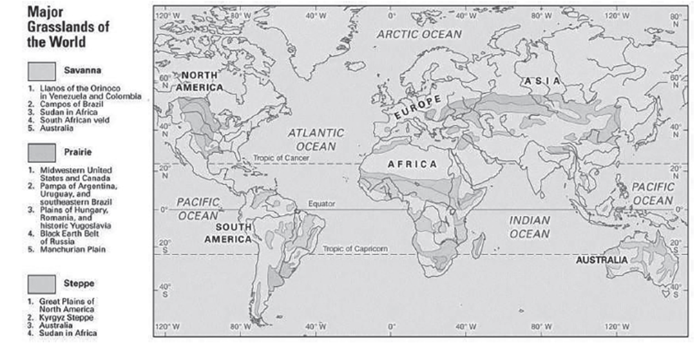
Different Names of Temperate Grasslands:
- Puszta: Located in Hungary and surrounding regions, the Puszta represents a significant temperate grassland area in Europe.
- Prairies: Spanning across North America between the foothills of the Rockies and the Great Lakes, the Prairies are renowned for their expansive grasslands.
- Pampas: Situated in Argentina and Uruguay, the Pampas experience a rain-shadow effect, shaping their unique ecosystem.
- Bushveld: Found in northern South Africa, the Bushveld is characterized by more tropical features within the temperate grassland biome.
- Highveld: Located in southern South Africa, the Highveld exhibits more temperate characteristics compared to the Bushveld.
- Downs: Encompassing the Murray-Darling basin of southern Australia, the Downs are a significant part of the Australian temperate grasslands.
- Canterbury: Present in New Zealand, the Canterbury region features temperate grasslands with distinct environmental factors.
Temperature:
- Continental Climate: Temperate grasslands typically experience a continental climate with extreme temperature variations.
- Seasonal Temperature Variability: Temperatures fluctuate significantly between summer and winter, with hot summers ranging from 18°C to 20°C and cold winters.
- Milder Conditions in Southern Hemisphere: In the southern hemisphere, the severity of temperature fluctuations tends to be less pronounced compared to the northern hemisphere.
Precipitation:
- Average Rainfall: Temperate grasslands receive an average rainfall of about 45 cm annually, although this varies considerably depending on location, ranging from 25 cm to 75 cm.
- Seasonal Rain Patterns: The heaviest rainfall typically occurs in June and July, which marks late spring and early summer in these regions.
- Winter Precipitation: During winter, most months receive around 2.5 cm of precipitation, often in the form of snow, brought by occasional depressions of the Westerlies.
- Maritime Influence: In the southern hemisphere, temperate grasslands may experience more rainfall due to maritime influences, contributing to a slightly different precipitation pattern compared to those in the northern hemisphere.
Natural Vegetation of Steppe Climate:
- Characteristics of Steppes:
- Steppes are characterized by being practically treeless, in contrast to tropical savanna climates.
- Grasses in steppes are typically shorter but still fresh and nutritious, resembling the grasses found in the wheat lands of North America.
- In regions with light or unreliable rainfall, or poor soil conditions such as the continental interiors of Asia, short steppe grasses prevail.
- The grasses in steppes are shorter, wiry (lean and tough), and sparse (thinly dispersed or scattered), making them less suitable for arable farming but ideal for some forms of ranching, such as in the high plains of the USA.
- In cultivated regions like the wheat farms of the Prairies, double rows of trees are often planted around houses to provide shelter from strong winds.
- Animal Life:
- Steppes generally do not exhibit much diversity in animal species.
- However, horses are common in Asian steppes, and they have historically played a significant role in the cultures and economies of these regions.
- Economic Development:
- Steppes are crucial for wheat and maize cultivation, contributing to their economic development.
- The grasslands have been extensively plowed for mechanized wheat cultivation, particularly in regions like the Prairies, which have become known as the “Granaries of the world.”
Overall, the natural vegetation of steppe climates consists primarily of short, tough grasses adapted to the semi-arid conditions, supporting limited animal diversity but playing a vital role in agricultural production, particularly for wheat cultivation.
The Cool Temperate Western Margin (British Type) Climate
The Cool Temperate Western Margin, often referred to as the British Type Climate, encompasses a unique climatic zone characterized by its distinct weather patterns, temperatures, precipitation, and seasonal changes. This climate is predominantly influenced by the Westerlies throughout the year and is known for its high levels of cyclonic activity, a trait it shares with Britain, thus earning its alternative name, the British type of climate.
Geographic Spread
This climate zone stretches across the cool temperate western margins of continents, particularly in the northwestern part of Europe. It covers areas from Britain to the lowlands of North-West Europe, enveloping northern and western France, Belgium, the Netherlands, Denmark, western Norway, and the northern and western parts of the Iberian Peninsula. This widespread coverage underscores the influence of maritime conditions on these regions, providing a distinctive climatic identity that separates them from their continental counterparts.
Temperature Characteristics
- Average Annual Temperature: The climate maintains an average annual temperature ranging between 5°C and 15°C. This relatively mild temperature range is attributed to the moderating effects of the North Atlantic Drift, which warms the region during the winter months.
- Winter Mildness: Winters are notably mild due to the North Atlantic Drift’s warming influence, contrasting sharply with the potential invasions of cold polar continental air, sometimes referred to as the Polar Vortex. These invasions can cause significant, though temporary, drops in temperature, leading to extraordinary cold spells.
Precipitation Patterns
- Annual Rainfall: This climate zone experiences ample rainfall throughout the year, with a slight inclination towards a winter maximum. This is largely due to the presence of frontal cyclones during the colder months.
- Rain Distribution: The Westerlies are responsible for most of the precipitation, particularly on the western edges of the continents, ensuring a steady supply of moisture throughout the year.
Seasonal Changes
- Distinct Seasons: The Cool Temperate Western Margin Climate is characterized by four distinct seasons, each with its own set of weather patterns.
- Winter: This season is marked by cloudy skies, foggy and misty mornings, and a significant number of rainy days, resulting from passing depressions.
- Spring: Following the dreary winter, spring emerges as the driest and most refreshing season, with everything turning green again.
- Summer: The climate transitions into a long, warm, sunny period, providing a stark contrast to the earlier seasons.
- Autumn: Characterized by howling winds, autumn signals the transition back into the colder months, completing the annual cycle.
Unlike tropical climates, where such distinct seasonal changes are absent, the Cool Temperate Western Margin Climate offers a vivid illustration of the temperate zone’s dynamic weather patterns. This climate’s unique combination of temperature stability, consistent precipitation, and clear seasonal transitions supports a diverse ecosystem and influences the agricultural practices, lifestyle, and culture of the regions it encompasses.
Lumbering
In the Cool Temperate Western Margin climate zones, forestry plays a crucial role, with significant differences in tree species and their uses compared to equatorial forests.
- Deciduous Trees: These trees, including species like oak, elm, and beech, grow in pure stands and are highly valued for logging due to their hardwood. This wood is used in furniture-making, construction, and other industries requiring durable wood.
- Conifers: Softwood trees, primarily conifers, are harvested at higher elevations. They are integral to the paper and pulp industries, contributing to the production of paper, cardboard, and related products. These areas are also home to advanced industrial activities, with regions like the Ruhr in Germany and cities in the UK being notable manufacturing hubs.
Mixed Farming
The practice of mixed farming, combining crop cultivation and animal husbandry, is prevalent in these climates, influenced by the fertile soils and moderate climate.
- Crops: Wheat and barley are the primary crops, with wheat mainly for domestic consumption and high-quality barley used in the beer and whisky industries.
- Livestock: Cattle are significant for both dairy and meat production, while sheep provide wool and meat. The region also engages in specialized productions like dairy in Denmark and the Netherlands, and Merino wool in Tasmania, indicating a diversified agricultural base.
Natural Vegetation
The deciduous woodland is the primary natural vegetation, with trees adapted to the seasonal climate by shedding their leaves in winter.
- Tree Species: Common species include oak, elm, ash, birch, beech, and poplar, which are utilized for various purposes, from construction to the manufacturing of specific goods like cricket bats from willows.
- Coniferous Trees: At higher altitudes, deciduous trees give way to conifers, capable of surviving in harsher conditions. These trees are vital for lumbering activities in mountainous regions.
Significance
The Cool Temperate Western Margin climate zones offer a combination of ecological diversity and economic opportunities.
- Industrial and Agricultural Symbiosis: The presence of rich natural resources supports a range of industries, from manufacturing and lumbering to agriculture and animal husbandry. This diversification contributes to the high standard of living and industrial development in these regions.
- Environmental Adaptation: The natural vegetation and agricultural practices have evolved to adapt to the climate’s characteristics, including its predictable rainfall pattern and moderate temperatures, which are conducive to year-round agricultural activities.
The integrated approach to land use, combining industrial development with agricultural and forestry practices, showcases the adaptability and resilience of societies and economies in the Cool Temperate Western Margin climate zones. This climate’s influence extends beyond mere weather patterns, shaping the economic structures, lifestyle, and even the cultural identity of the regions it encompasses.
Siberian Climate & Taiga Type of Climate
The Siberian and Taiga climates, also referred to as the Boreal Climate, Cool Temperate Continental Climate, or Continental Subpolar Climate, represent a unique and extreme weather pattern that dominates vast regions primarily in the Northern Hemisphere. This detailed examination explores the characteristics, temperature variations, geographical distribution, and environmental impact of these climates.
Characteristics of Siberian and Taiga Climates
-
- Harsh, Cold Environment: These regions experience a severe, cold climate with minimal precipitation, including both snow and rain. The cold conditions are a defining feature, making it a challenging environment for both flora and fauna.
- Long Winters: Winters last up to six months, characterized by average temperatures well below freezing. This prolonged period of cold significantly impacts the ecological cycle and human activities in these regions.
- Short Summers: Summer is brief, lasting only 50 to 100 days without frost. Despite the short duration, summers can be mild and are crucial for the growth cycle of the region’s limited vegetation.
- Precipitation: Although precipitation is low, snow cover during the winter plays a crucial role in insulating the ground, affecting soil temperatures and permafrost conditions.
Geographical Distribution
- Northern Hemisphere Dominance: The Taiga climate is primarily found in the northern hemisphere due to its large east-west extent. It is not present in the Southern Hemisphere because of the narrower landmasses at high latitudes which do not support this type of climate.
- Regions Covered: It spans central Canada, parts of Scandinavian Europe, and most of central and southern Russia. This continuous band stretches from approximately 50 to 70 degrees North latitude.
- Absence in the Southern Hemisphere: The Southern Hemisphere’s geography, with its narrow continents at high latitudes, does not support the development of a Taiga climate. Only certain high-altitude areas in southern Chile, New Zealand, Tasmania, and southeast Australia have similar coniferous forests.

Temperature
- Summer Conditions: Summers are short but pleasant, with average temperatures ranging between 20 to 25 degrees Celsius. This brief period is vital for the region’s ecological processes.
- Winter Conditions: Winters are notoriously long and cold, with average temperatures dropping to 30-40 degrees Celsius below freezing. Some locations, like Verkhoyansk, have recorded some of the world’s lowest temperatures.
- Comparative Extremes: The severity of the climate extremes is less pronounced in North America compared to Eurasia, due to the continent’s shorter east-west stretch. This geographical difference influences the climate’s impact on the ecosystem and human habitation.
Environmental and Ecological Impact
- Permafrost: A significant feature of this climate is the presence of permafrost—a thick underground layer of soil that remains frozen throughout the year. While permafrost can act as a barrier to the cold for the soil beneath, it also poses challenges for vegetation and human infrastructure.
- Flora and Fauna: The harsh conditions limit biodiversity. However, the ecosystems here, adapted to the extreme climate, are resilient and play crucial roles in global carbon cycling and biodiversity.
- Human Adaptation: Human habitation and activities in these areas are significantly influenced by the climate. Adaptations include architectural designs to withstand the cold, seasonal adjustments in lifestyle and economic activities, and strategies to mitigate the impact of permafrost on infrastructure.
The Siberian and Taiga climates, with their distinctive features and challenges, are vital to understanding global climate patterns, ecological processes, and the adaptation of life in extreme conditions.
Precipitation
- Winter Precipitation: During the winter months, precipitation mainly falls in the form of snow due to mean temperatures consistently remaining below freezing. Frontal disturbances can occur, contributing to the overall precipitation during this season.
- Annual Precipitation: The average yearly precipitation ranges between 38 cm to 63 cm, which, while not abundant, is significant enough to sustain the dense coniferous forests characteristic of the region.
- Summer Precipitation: The summer months see maxima due to convectional rain, with temperatures ranging from 15 °C to 24 °C. This precipitation is relatively evenly distributed throughout the year, supporting the growth of vegetation during the brief, warmer months.
Natural Vegetation
- Evergreen Coniferous Forests: Dominating the landscape, these forests are well adapted to the sub-Arctic climate. The conifers require little rainfall to thrive, making them perfectly suited to this environment.
- Geographical Spread: In North America, the belt of coniferous forest extends from Alaska, through Canada, and into Labrador. In Europe, while vast areas of natural coniferous forest are less common, countries like Germany, Poland, Switzerland, and Austria do have small areas of such forests.
- Softwood Trees: These forests are the richest sources of softwood trees in both Eurasia and North America. The timber from these trees is essential for various industries, including construction, furniture making, matches, paper and pulp production, rayon, and other chemical industries.
Significance of the Taiga
- Ecosystem Health and Stability: The Taiga biome is crucial for the planet’s health, contributing significantly to the global carbon cycle. Its dense forests act as a major carbon sink, absorbing carbon dioxide from the atmosphere and helping to mitigate the effects of climate change.
- Biodiversity and Environment: Despite the challenging conditions, the Taiga supports a diverse range of flora and fauna adapted to its environment. It is a stunningly beautiful landscape that provides habitat for many species, contributing to global biodiversity.
- Economic and Environmental Importance: The Taiga’s natural resources, especially its vast forests, have significant economic value. They are vital for the timber industry and play a crucial role in the livelihoods of many communities. Additionally, the Taiga plays an essential role in water regulation and purification.
Laurentian Climate: An In-depth Analysis
The Laurentian climate, characterized as a cool temperate eastern margin climate, represents a unique blend of climatic features found in specific regions of the Northern Hemisphere.
Definition and Characteristics
- Intermediate Nature: The Laurentian climate serves as a transitional climate type, combining elements of the maritime climate (British type) and the continental climate (Siberian type). It exhibits characteristics of both, making it distinct in its variability and the range of weather patterns it supports.
- Geographical Distribution: This climate is predominantly found in two major regions of the Northern Hemisphere:
- North-Eastern North America: Encompassing Eastern Canada (including Newfoundland) and the North-Eastern United States (including the Maritime Provinces and New England States).
- Eastern Asia: Covering the eastern coastlands of Asia, including Eastern Siberia, North China, Manchuria, Korea, and northern Japan.
- Absence in the Southern Hemisphere: The Laurentian climate is notably absent in the Southern Hemisphere. This is primarily due to the limited landmass extending beyond 40 degrees south and the dominant maritime influence, which negates the formation of both continental and eastern margin climates.
Climatic Conditions
- Temperature and Precipitation: The Laurentian climate is characterized by cold, dry winters and warm, wet summers. Winter temperatures can drop well below the freezing point, leading to substantial snowfall. Conversely, summers are warm, with temperatures around 25°C, potentially hotter if not for the cooling effects of offshore Arctic currents.
- Annual Precipitation: Ranging from approximately 75 to 150 cm, the Laurentian climate sees about two-thirds of its precipitation during the summer months. This pattern supports a variety of flora and fauna adapted to these conditions.
Regional Characteristics
- North-Eastern American Region: This area exhibits a remarkable uniformity in precipitation, with a slight peak during the late summer months (July and August). Such uniformity results largely from the Atlantic Ocean’s influence and the presence of the Great Lakes.
- Influence of Ocean Currents:
- Warm Gulf Stream: Enhances the moisture content of easterly winds from the open Atlantic, contributing to increased precipitation, especially during the winter months.
- Cold Labrador Current: The convergence of the warm Gulf Stream and the cold Labrador Current off the coast of Newfoundland produces dense mist and fog, leading to significant precipitation. This phenomenon is crucial for the region’s agriculture, as it provides necessary moisture during the growing season.
Natural Vegetation and Economic Activities in the Laurentian Climate
The Laurentian climate, with its distinct seasonal variations and geographical characteristics, supports a unique array of natural vegetation and drives various economic activities in the regions it encompasses. This analysis explores the types of natural vegetation found within this climate zone, their distribution, and the primary economic practices that have developed in response to the climatic and environmental conditions.
Natural Vegetation
- Coniferous Forests: North of 50°N latitude, the dominant vegetation type is coniferous forests, which are an extension of the vast coniferous belt of the Taiga. In Asia, specifically in eastern Siberia and Korea, these forests seamlessly continue the Taiga’s coniferous coverage, creating a dense forest landscape that is both ecologically significant and economically valuable.
- Deciduous Forests: South of 50°N latitude, there is a transition from coniferous to deciduous forests. This zone is characterized by the presence of oak, beech, maple, and birch as the principal tree species. These forests mark a notable change in the ecosystem, supporting a different variety of flora and fauna and offering diverse economic resources compared to their northern counterparts.
Economic Activities
- Lumbering and Associated Industries: The extensive forests in the Laurentian climate zones serve as the foundation for the lumbering industry and its related sectors, including timber, paper, and pulp industries. These industries are crucial for the regional economies, providing employment, fostering industrial growth, and contributing significantly to exports.
- Agricultural Development: While the harsh winters and long cold spells limit the scope of agriculture, the regions under the Laurentian climate do support the cultivation of hardy crops. Potatoes, oats, rye, and barley are among the primary crops grown, catering mostly to local needs. The maritime influence and adequate rainfall make agriculture feasible, albeit less significant than in more temperate regions.
- Fishing: The Laurentian climatic regions, particularly in places like Newfoundland and Japan, benefit from their geographical positioning at the confluence of warm and cold ocean currents. This unique setting creates an environment rich in plankton, which serves as a primary food source for fish. The gently sloping continental shelves around Newfoundland and Japan are especially productive fishing grounds, making fishing a vital economic activity. The abundance of fish not only supports local economies but also plays a crucial role in global seafood markets.
Tundra
The tundra biome is a distinct and fascinating ecosystem, marked by its extreme cold, limited precipitation, short growing seasons, and unique adaptations of plants and animals to survive in such harsh conditions. Understanding the tundra involves exploring its climate characteristics, geographical distribution, and the environmental challenges it presents.
Climate Characteristics
The tundra is characterized by its Köppen climate classification as a type with subfreezing mean annual temperatures. This classification highlights several key aspects of the tundra climate:
- Subfreezing Mean Annual Temperatures: The average annual temperature is below freezing, typically ranging from -25 to -30 degrees Centigrade (-13 to -22 degrees Fahrenheit), making it the coldest of all terrestrial biomes.
- Large Annual Temperature Ranges: While not as extreme as the adjacent continental subarctic climate, the tundra experiences significant temperature fluctuations between seasons.
- Moderately Low Precipitation: Precipitation is low, typically ranging from 150 to 250 mm (6 to 10 inches) annually, which falls primarily as snow. This low precipitation contributes to the desert-like conditions in many tundra regions.
- Extreme Environmental Conditions: The tundra is known for its frost-molded landscapes, extremely low temperatures, little precipitation, depleted nutrients, and short growing seasons, which create a challenging environment for life.
Distribution
The tundra biome is primarily found in the high latitudes of the northern and southern hemispheres:
- Northern Hemisphere: North of the Arctic Circle, encompassing parts of northern Canada, Alaska, northern Scandinavia, Siberia, and Russia.
- Southern Hemisphere: South of the Antarctic Circle, particularly the Antarctic Peninsula and the surrounding islands. The interior of Antarctica is often considered a separate ice cap climate due to its even more extreme conditions.
- Highland Regions: Apart from latitudinal distribution, tundra conditions can also be found in high-altitude locations such as the ice caps of Greenland and Antarctica, where altitude creates conditions similar to those found in polar regions.
- Lowland Regions: Coastal areas of Greenland, northern Canada, Alaska, and Eurasia’s Arctic shorelines exhibit tundra climates due to their latitude and the influence of cold ocean currents.
Temperature and Light Conditions

- Severe Cold: Mean annual temperatures are extremely low, with winter temperatures capable of dropping to -40 to -50 °C (-40 to -58 °F). The soil remains frozen year-round, a condition known as permafrost.
- Short Summers: The tundra experiences very short summers, with temperatures just above freezing, allowing for a brief growing season of approximately 50-60 days. This period is critical for the entire ecosystem, as it allows plants to grow and reproduce, and animals to feed and prepare for the winter.
- Polar Nights and Midnight Sun: Due to its high latitude, the tundra experiences periods of continuous daylight in summer and continuous darkness in winter. This extreme variation in daylight affects the behavior and physiological processes of the region’s flora and fauna.
Environmental Challenges
The tundra biome presents numerous challenges for survival:
- Limited Vegetation: The short growing season and permafrost limit plant growth to low shrubs, grasses, mosses, and lichens.
- Animal Adaptations: Animals in the tundra, such as the Arctic fox, caribou, and polar bear, have adapted to the cold with insulating layers of fat, specialized diets, and seasonal migrations.
- Human Impact: Climate change poses a significant threat to the tundra, with rising temperatures affecting permafrost and altering the delicate balance of these ecosystems.
Precipitation
In the tundra, precipitation is minimal and comes primarily in the form of snow and sleet. Due to the cold temperatures, the moisture content in the air is low, leading to sparse precipitation. Convectional rainfall, common in warmer climates where the sun heats the ground and causes water to evaporate and then condense as it cools in the atmosphere, is almost non-existent in the tundra due to the consistently low temperatures.
Natural Vegetation
The harsh climate of the tundra limits the types of vegetation that can survive:
- No Trees: The permafrost and short growing seasons prevent trees from taking root in the tundra.
- Mosses and Lichens: These are the most common forms of vegetation, able to survive with minimal soil and nutrients.
- Coastal Vegetation: The climate in coastal lowlands is slightly more favorable for vegetation, allowing for the growth of reindeer moss and resistant grasses, which provide important food sources for local wildlife.
- Summer Bloom: During the brief summer, berry-bearing bushes and Arctic flowers can bloom, and a surge of insects provides a food source for migrating birds.
Wildlife
The fauna of the tundra has adapted to the extreme conditions:
- Mammals: Include wolves, foxes, musk-ox, Arctic hare, and lemmings, which have evolved to survive the cold and scarcity of food.
- Penguins: Are exclusively found in Antarctica, having adapted perfectly to its conditions.
- Migratory Birds: Travel to the tundra in the summer to take advantage of the insect population.
Human Activities
Human activities in the tundra are adapted to the challenging environment:
- Semi-nomadic Lifestyle: Indigenous peoples like the Eskimos (Inuit) in Greenland, northern Canada, and Alaska live a lifestyle adapted to the extreme conditions, including seasonal migrations and traditional shelters like igloos.
- Subsistence: They rely on fishing and hunting marine mammals such as seals, walruses, and polar bears for food. Traditional hunting methods are being supplemented or replaced by modern techniques, including the use of rifles.
Recent Advancements
Economic activities in the tundra have expanded due to the discovery of natural resources:
- Mining: Gold in Alaska, petroleum on the Kenai Peninsula, copper in Canada’s Rankin Inlet, and increasingly important iron ore deposits in Labrador reflect the growing economic development in these regions.
- Navigation: Modern icebreakers have made the freezing seas navigable, opening new routes for trade and exploration.
These developments have led to the formation of new communities and brought modern challenges to these fragile ecosystems, including environmental impacts from mining and increased navigation. The balance between exploiting these resources and preserving the unique environments of the tundra is a key concern for conservationists, policymakers, and indigenous communities.
UPSC PREVIOUS YEAR QUESTIONS
1. Discuss the meaning of colour-coded weather warnings for cyclone prone areas given by India Meteorological Department.
2. “Climate is extreme, rainfall is scanty and the people used to be nomadic herders.”
The above statement best describes which of the following regions? (2013)
(a) African Savannah
(b) Central Asian Steppe
(c) North American Prairie
(d) Siberian Tundra
3. Consider the following statements: (2012)
The duration of the monsoon decreases from southern India to northern India.
The amount of annual rainfall in the northern plains of India decreases from east to west.
Which of the statements given above is/are correct?
(a) 1 only
(b) 2 only
(c) Both 1 and 2
(d) Neither 1 nor 2
4. Seasonal reversal of wind is typical characteristic of (2014)
(a) Euitorial climate
(b) Mediterranean climate
(c) Monsoon climate
(d) All of the above climate