DISTRIBUTION OF OCEAN AND CONTINENTS
Introduction
The configuration of continents and oceans on Earth is not static. Throughout geological history, the arrangement of these land and water bodies has undergone significant changes, and it will continue to evolve in the future. To explain the dynamic nature of Earth’s surface, scientists have developed various theories over time. One of the most groundbreaking and foundational theories in this regard is the Continental Drift Theory, which offers insights into the past distribution of continents and oceans and predicts their future movements.
Continental Drift Theory
Origins and Proponent
The Continental Drift Theory was introduced by Alfred Wegener in 1912. Wegener was a meteorologist and geophysicist who, through extensive research and observation, proposed a revolutionary idea that challenged the prevailing geographical and geological understanding of the time.
Core Concepts
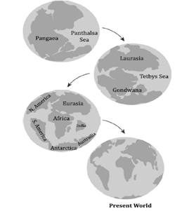
- Pangaea: At the heart of Wegener’s theory is the concept of Pangaea, a supercontinent that existed approximately 300 million years ago during the late Paleozoic and early Mesozoic eras. According to Wegener, all the current continents were once joined together in this massive landmass.
- Panthalassa: Surrounding Pangaea was a single, vast ocean called Panthalassa. This encompassing water body covered the rest of the Earth’s surface not occupied by Pangaea.
Process of Drift
- Mesozoic Era Breakup: Wegener proposed that around 200 million years ago (MYA), during the Mesozoic era, Pangaea began to fragment and drift apart. This monumental geological shift led to the formation of two large landmasses: Laurasia in the north and Gondwanaland in the south.
- Laurasia and Gondwanaland: These two resultant continents moved away from each other, separated by the Tethys Sea (not river, as it was a significant body of water rather than a river). Laurasia eventually formed the continents of North America, Greenland, and Eurasia (excluding the Arabian Peninsula and India). In contrast, Gondwanaland gave rise to South America, Africa, Australia, Antarctica, and India.
- Northward and Southward Drift: The theory further suggests that these landmasses continued to drift in opposite directions, with Laurasia moving northward and Gondwanaland moving southward. This drift has resulted in the current distribution of continents.
Significance and Impact
Wegener’s Continental Drift Theory was groundbreaking for several reasons. It provided a coherent explanation for numerous geological and paleontological observations that were otherwise difficult to explain, such as the matching geological formations and fossil records across continents that are now widely separated by oceans.
However, Wegener’s theory initially faced skepticism and criticism from the scientific community, primarily because he could not provide a convincing mechanism for the movement of the continents. It wasn’t until the development of the theory of plate tectonics in the mid-20th century, which described the Earth’s lithosphere divided into tectonic plates that move over the asthenosphere, that Wegener’s ideas were fully vindicated. The theory of plate tectonics provided the mechanism that was missing from Wegener’s original theory, thereby solidifying the concept of continental drift as a cornerstone of modern geology.
Evidence in Support of the Continental
Drift Theory
The theory of continental drift, first proposed by Alfred Wegener in the early 20th century, posits that the continents once formed a single landmass called Pangaea, which gradually drifted apart to their current positions. This theory is supported by various lines of evidence that indicate a common history among continents now separated by oceans.
1. Jigsaw Fit of Continents
- South America and Africa: The coastlines of South America and Africa fit together remarkably well, like pieces of a jigsaw puzzle. This suggests they were once joined.
- India, Madagascar, and Africa: The continental margins of these landmasses also suggest a past connection, indicating they may have been part of the same landmass before drifting apart.
2. Rocks of the Same Age Across the Ocean
- Jurassic Rocks: Rocks of the same Jurassic age found along the coastlines of South America and Africa suggest these areas were connected before the Atlantic Ocean formed, as it’s unlikely these formations could span such distances unless the continents were once joined.
- Ancient Rock Belts: Similar ancient rock formations along the Brazil coastline and Western Africa further support this, indicating a shared geological history before the continents separated.
3. Glacial Tillite
- Glacier Sedimentary Deposits: Tillite, a type of sedimentary rock formed from glacial deposits, has been found in regions now located in warm climates, indicating they once experienced the same glacial conditions.
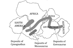
- Shared Origins: The presence of tillite formations of the same age in India, Madagascar, Africa, Antarctica, Falkland Island, and Australia suggests these now distant landmasses were once part of a single, southern supercontinent.
4. Fossil Deposits
- Cynognathus, Mesosaurus, and Glossopteris: The discovery of fossils of these species in places now separated by vast oceans (such as Africa and South America) indicates these continents once shared a common environment, allowing the same species to inhabit across these regions.
5. Placer Deposits
- Gold Deposits: The presence of placer gold deposits along the western coast of Africa, where no gold-bearing rocks exist, alongside similar deposits and gold-bearing rocks in Brazil suggests these continents were once adjacent. This proximity would explain the shared placer deposits despite the current geographical separation.
6. Polar Wandering
- Shift in Pole Positions: Evidence from the study of the Earth’s magnetic field recorded in rocks indicates that the positions of the magnetic poles have shifted over time. This polar wandering is consistent with the movement of continents on the Earth’s surface, further supporting the theory of continental drift.
Each of these pieces of evidence contributes to the robust support for the theory of continental drift, illustrating how continents not only fit together physically but also share a common geological, climatological, and biological history. This evidence has laid the groundwork for the modern understanding of plate tectonics, which provides a mechanism for the movement of the continents through the shifting of the Earth’s lithospheric plates.
Forces for Continental Drift
The theory of Continental Drift, primarily proposed by Alfred Wegener in the early 20th century, posits that the continents have not always been fixed in their current positions but have moved across the Earth’s surface over geological time. This theory was groundbreaking because it suggested a dynamic Earth where continents could drift apart or come together. Wegener proposed several forces to explain this movement, including polar fleeing force, tidal force, buoyant force, and gravitational force. However, his theory faced significant criticism, particularly regarding the forces he proposed for continental movement.
Forces for Continental Drift
1. Polar Fleeing Force
- Explanation: This force is related to the Earth’s rotation. Wegener suggested that the centrifugal force resulting from the Earth’s rotation causes continents to move away from the poles and towards the equator.
- Detail: The idea is based on the principle that objects on a rotating sphere experience an outward force (centrifugal force) that is stronger at the equator than at the poles. Wegener hypothesized that this difference could cause continents at higher latitudes to drift towards lower latitudes.
2. Tidal Force
- Explanation: Tidal forces result from the gravitational pull of the moon and the sun on the Earth.
- Detail: Wegener proposed that these forces could cause the continents to move westward. He thought that as the Earth rotates eastward under the pull of the moon and the sun, the continents might lag slightly behind due to tidal attraction, causing a gradual westward drift.
3. Buoyant Force
- Explanation: This force is based on the principle of buoyancy, which suggests that less dense materials float atop denser materials.
- Detail: Wegener suggested that continents, being less dense than the oceanic crust, float on the denser underlying mantle, which could facilitate their movement.
4. Gravitational Force
-
- Explanation: Wegener included the Earth’s gravitational pull as a force that might influence the drift of continents.
- Detail: He proposed that variations in gravitational forces across the Earth’s surface could contribute to the movement of continents, though this idea was not as fully developed as his other propositions.
Criticisms of Wegener’s Theory
1. Timing of Drift
- Wegener’s theory could not explain why continental drift began only in the Mesozoic era and not earlier, leading to questions about the validity of the proposed forces.
2. Direction of Movement
- The theory mainly accounted for northward and westward movement, ignoring evidence that continents move in all directions. This limitation suggested a misunderstanding of the forces involved or an oversimplification of Earth’s dynamics.
3. Incorrect Forces
The forces Wegener proposed (polar fleeing force, tidal force, etc.) were later found to be insufficient to cause continental drift. The primary mechanism for the movement of the continents is now understood to be mantle convection within the asthenosphere, beneath the Earth’s crust.
4. Jigsaw Fit Evidence
-
- Critics also pointed out flaws in Wegener’s evidence for a “jigsaw fit” of continents, especially since coastlines change over time due to erosion and sediment deposition, making it unreliable to use current coastlines as evidence for past connections.
Despite these criticisms, Wegener’s theory laid the groundwork for the development of plate tectonics, which provides a comprehensive explanation for the movement of the Earth’s plates, including continents. The concepts of Pangea (the supercontinent) and Panthalassa (the superocean) proposed by Wegener are now well-accepted and form the basis for understanding the geological history of the Earth. While the specific forces Wegener proposed were not correct, his insight that the continents had moved was revolutionary and has been crucial in the advancement of geosciences.
POST DRIFT THEORIES
Convectional Current Theory: A Cornerstone of Plate Tectonics
The Convectional Current Theory, proposed by Arthur Holmes in the 1930s, is a fundamental concept in the field of geology, specifically in the study of plate tectonics and continental drift. This theory explains the movement of the Earth’s lithospheric plates through the mechanism of convection currents within the mantle, driven by the heat produced from radioactive decay.
Background and Genesis of the Theory
Arthur Holmes, a pioneering geologist, introduced the Convectional Current Theory as an explanation for the observed movement of continents, known as continental drift. Prior to Holmes’s work, the idea that continents could move was highly controversial and lacked a plausible mechanism.
The Structure of the Earth
- Lithosphere: The outermost layer, comprising the crust and the uppermost part of the mantle.
- Mantle: Located beneath the lithosphere, it is made of semi-solid rock that behaves fluidly over long timescales.
- Core: The innermost part of the Earth, consisting of a liquid outer core and a solid inner core.
The Role of Radioactive Decay
Holmes posited that the decay of radioactive elements within the Earth generates significant heat, leading to thermal differences within the mantle. These thermal differences are the driving force behind convection currents.
Mechanics of Convection Currents
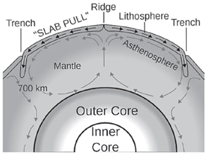
Convection currents operate on the principle that hot, less dense material rises, while cooler, denser material sinks. This cyclical movement within the mantle is responsible for the movement of the Earth’s lithospheric plates.
Rising Limb
- Formation of Oceanic Ridges: The upward movement of convection currents causes the lithospheric plates to diverge at certain boundaries. This divergence leads to the formation of oceanic ridges, where magma from the mantle rises to fill the gap, creating new crust.
Descending Limb
- Formation of Trenches: The downward movement of convection currents pulls lithospheric plates toward each other, leading to the convergence of plates. At these convergent boundaries, one plate is forced beneath another into the mantle, forming deep oceanic trenches.
Implications of the Convectional Current Theory
The Convectional Current Theory has significantly advanced our understanding of Earth’s geological dynamics.
- Plate Tectonics
- It provides a coherent mechanism for the theory of plate tectonics, explaining not only the movement of the continents but also the interaction between lithospheric plates.
- Geological Features
- The theory explains the formation of major geological features such as mountain ranges, formed by the collision of continental plates, and volcanic activity, primarily located along plate boundaries where magma can escape to the surface.
- Earthquakes and Volcanoes
- By explaining the movement and interaction of lithospheric plates, the Convectional Current Theory helps to predict the locations of earthquakes and volcanic activity, which are most common along plate boundaries.
Arthur Holmes’s Convectional Current Theory has been a key development in the field of geology, providing a robust explanation for the movement of lithospheric plates and the associated geological phenomena. It laid the groundwork for the modern understanding of plate tectonics, revolutionizing our comprehension of Earth’s dynamic interior and its surface processes. This theory remains central to geological studies, helping scientists to decipher the complex interactions that shape our planet’s surface over geological time.
MAPPING OF THE OCEAN FLOOR
Mapping of the ocean floor has significantly enhanced our understanding of Earth’s geology, hydrography, and the dynamic processes shaping the planet. The use of sonar (Sound Navigation and Ranging) technology has been pivotal in this exploration, enabling scientists to map the topography of the ocean bed accurately. This process has unveiled a complex and varied terrain beneath the oceans, characterized by mountain ranges, deep trenches, and other geological features. The key insights gained from mapping the ocean floor include:
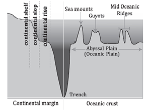 1. Youth of Oceanic Crust Compared to Continental Crust
- Observation: Sediments on the ocean floor are nowhere older than 200 million years, in stark contrast to the continents, where the oldest rocks can be up to 3200 million years old.
- Implication: This suggests that the oceanic crust is significantly younger than the continental crust. The absence of very old sediments in the ocean basins points to dynamic processes that renew the ocean floor, such as volcanic activity and plate tectonics.
2. Volcanic Activity Along the Mid-Oceanic Ridge
- Observation: Continuous volcanic activities are observed along the mid-oceanic ridge, which are confined to this area.
- Implication: This activity is indicative of the creation of new oceanic crust through the process of seafloor spreading. Magma rises from the mantle at these mid-ocean ridges, cools, and solidifies to form new crust, pushing the older crust away from the ridge.
3. Age Gradient of Oceanic Rocks
- Observation: The age of the rocks increases as one moves away from the mid-ocean ridge towards the trenches.
- Implication: This age gradient is a clear indication of seafloor spreading. The youngest rocks are found at the ridge, where new crust is formed, and the age of the rocks increases with distance from the ridge, highlighting the continuous and gradual process of oceanic crust formation.
4. Symmetry of Rock Ages and Types Across the Ridge
- Observation: Rocks of similar type and age are found on either side of the mid-ocean ridge at equal distances.
- Implication: This symmetry supports the theory of seafloor spreading, suggesting that as the ocean floor expands from the ridge, it does so symmetrically, with similar materials being deposited on either side.
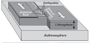
5. Earthquake Patterns
- Observation: Deep-seated earthquakes occur in the deep trenches, while in the areas of the mid-oceanic ridge, the earthquake foci have shallow depths.
- Implication: This pattern of seismic activity reflects the different geological processes occurring at these locations. At mid-ocean ridges, shallow earthquakes are associated with the upwelling of magma and the formation of new crust. In contrast, deep trenches are sites of subduction where one plate moves under another, leading to deeper earthquake foci.
Seafloor Spreading Theory
The Seafloor Spreading Theory, conceptualized by Harry Hess in the 1960s, marks a pivotal advancement in the field of geology, particularly in the understanding of plate tectonics and oceanography. This theory sheds light on the dynamic processes beneath the Earth’s oceans that contribute to the geological features observed today.
 Core Principles of the Theory
1. Mechanism of Seafloor Spreading
- The theory posits that the oceanic crust plays a vital role in the cyclical process of seafloor spreading, driven by convection currents within the Earth’s mantle. These currents are generated by the heat from the Earth’s core, causing magma to rise and spread outward at the ocean ridges.
2. Formation and Consumption of Oceanic Crust
- As magma emerges at the mid-ocean ridges, it cools and solidifies to form new oceanic crust. This crust gradually moves away from the ridge, driven by the underlying mantle convection currents. Eventually, the oceanic crust is consumed back into the mantle at subduction zones located at deep ocean trenches.
3. Non-Competitive Oceanic Expansion
- Contrary to what might be intuitively expected, the spreading of one oceanic section does not result in the shrinking of another. The process is balanced by the continuous creation of new crust at mid-ocean ridges and its simultaneous consumption at ocean trenches.
4. Recycling of the Oceanic Crust
- The oceanic crust undergoes a recycling process, where it is formed at mid-ocean ridges, moves across the ocean floor, and is eventually subducted back into the mantle, where it melts and is involved in new magma generation. This cycle can span millions of years.
5. Younger Crust Near Mid-Ocean Ridges
- The crust nearest to the mid-ocean ridges is significantly younger than that near the trenches. This age difference is a direct consequence of the continuous formation of new crust at the ridges.
6. Rate of Seafloor Spreading
-
- The rate at which the seafloor spreads can be measured by examining the age of rocks and their distance from mid-ocean ridges, alongside the symmetrical patterns of magnetic stripes found on the ocean floor.
Evidences Supporting the Theory
1. Geology of the Ocean Floor
- The varied geological features of the ocean floor, including mid-ocean ridges, deep-sea trenches, and transform faults, provide a physical framework supporting the theory.
2. Age of Rocks
- Studies show that the age of oceanic rocks increases with distance from the mid-ocean ridges, corroborating the theory’s assertion that new crust is continuously formed at these ridges.
3. Paleomagnetism
- The study of the Earth’s past magnetic fields, recorded in the oceanic crust, reveals patterns of magnetic stripes. These stripes are symmetrical about the mid-ocean ridges and indicate periodic reversals of the Earth’s magnetic field, further supporting the theory.
4. Thickness of Sediments
-
- Sediment thickness on the ocean floor increases with distance from the mid-ocean ridges. This observation is consistent with the theory, as newer crust at the ridges has less time to accumulate sediments compared to older crust further away.
Plate Tectonic
The Plate Tectonic Theory is a fundamental principle that describes the large-scale motion of Earth’s lithosphere. This theory has significantly advanced our understanding of Earth’s geological features, including the formation of continents, mountains, ocean basins, and the occurrence of earthquakes and volcanic activity. The theory was initially proposed by McKenzie and Parker in 1967 and was further elaborated by Morgan in 1968.
Foundation of Plate Tectonic Theory
- Historical Background
- Proposers: The theory was proposed by Dan McKenzie and Robert Parker in 1967, and its comprehensive outline was provided by W. Jason Morgan in 1968.
- Evolution: It evolved from the earlier theory of continental drift and was supported by extensive seafloor mapping and earthquake data.
- Basic Concept
- Lithospheric Plates: The Earth’s lithosphere is broken into several large and small plates, comprising both continental and oceanic crust.
- Asthenosphere: These plates float on the semi-fluid asthenosphere, which is the upper part of the mantle beneath the lithosphere.
Characteristics of Tectonic Plates
- Composition and Structure
- Dual Composition: A tectonic plate can consist of continental lithosphere (sialic, less dense, and thicker) and oceanic lithosphere (simatic, denser, and thinner).
- Massive Slabs: Plates are massive, irregularly shaped slabs of solid rock that move as rigid units over the asthenosphere.
- Classification of Plates
- Continental Plates: Also known as sialic plates, these are thicker and less dense, mainly composed of silica and aluminum.
- Oceanic Plates: Known as simatic plates, these are thinner but denser, composed primarily of silica and magnesium.
Dynamics of Plate Movement
- Mechanism
- Convection Currents: Plate movements are driven by convection currents in the mantle. These currents are caused by the heat from the Earth’s core and the decay of radioactive elements in the mantle.
- Rigid Movement: Despite the solid state, plates move horizontally over the asthenosphere as a cohesive unit, not bending or deforming easily.
- Interactions at Plate Boundaries
- Divergent Boundaries: Where plates move apart, new crust is formed from upwelling magma, creating mid-ocean ridges or rift valleys.
- Convergent Boundaries: Where plates move towards each other, the denser oceanic plate can subduct beneath the lighter continental plate, leading to mountain building, volcanic activity, and the formation of deep-sea trenches.
- Transform Boundaries: Where plates slide past each other horizontally, leading to earthquakes along faults like the San Andreas Fault in California.
Implications of Plate Tectonics
- Geological Features
- Mountain Ranges: Formed by the collision of continental plates.
- Ocean Basins: Created and modified by the movement of oceanic plates.
- Volcanic Activity: Primarily occurs at convergent boundaries and hotspots.
- Earthquakes
- Occurrence: Most earthquakes happen at plate boundaries due to the release of energy as plates move.
- Prediction: Understanding plate movements helps in predicting potential earthquake zones.
The Plate Tectonic Theory offers a comprehensive framework for understanding the dynamic nature of Earth’s surface. It explains the formation and interaction of the Earth’s crust and has revolutionized our understanding of geological processes. This theory not only elucidates the structural features of our planet but also provides insights into the mechanisms driving earthquakes, volcanic activities, and the creation of geographical features across the globe.
Major and Minor Plates
To provide a comprehensive overview of the major and minor tectonic plates, including their interactions and associated geologic phenomena, I’ll lay out the information in table format. This format will help clarify the relationships between the plates and the resulting geomorphic features and geologic phenomena they cause, such as mountains, ridges, volcanoes, earthquakes, and tsunamis.
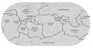
Major Tectonic Plates
| Plate Name | Description |
| Antarctica and the surrounding oceanic plate | Encompasses Antarctica and the ocean floor surrounding it, contributing to the formation of features around the Antarctic region. |
| North American plate | Covers North America and parts of the Atlantic Ocean, involved in the formation of the Rocky Mountains, and seismic activity along the western coast. |
| South American plate | Spans South America and parts of the Atlantic Ocean, known for the Andes mountains and seismic activity along the western margin. |
| Pacific plate | The largest tectonic plate covering the Pacific Ocean, associated with the Pacific Ring of Fire, known for intense seismic and volcanic activity. |
| India-Australia-New Zealand plate | A composite plate that includes India, Australia, and parts of the Indian Ocean, key in the formation of the Himalayas. |
| Africa with the eastern Atlantic floor plate | Covers the African continent and the adjacent Atlantic Ocean floor, involved in the East African Rift and other features. |
| Eurasia and the adjacent oceanic plate | Encompasses Europe, Asia, and parts of the North Atlantic Ocean, associated with the Alpine-Himalayan mountain ranges. |
Minor Tectonic Plates
| Plate Name | Location | Interactions and Features |
| Cocos plate | Between Central America and Pacific plate | Known for volcanic and seismic activity along the Central American Volcanic Arc. |
| Nazca plate | Between South America and Pacific plate | Responsible for the Andes mountains and seismic activity along the South American coast. |
| Arabian plate | Mostly the Saudi Arabian landmass | Involved in the formation of the Zagros Mountains and seismic activity in the Middle East. |
| Philippine plate | Between the Asiatic and Pacific plate | Associated with the Philippine Archipelago and significant seismic and volcanic activity. |
| Caroline plate | Between the Philippine and Indian plate (North of New Guinea) | Plays a role in the complex boundary interactions in the western Pacific. |
| Fuji plate | North-east of Australia | Identified with minor seismic activity and interactions with the Pacific and Indo-Australian plates. |
| Turkish plate | Part of Turkey | Associated with seismic activity and the complex geology of the Anatolian region. |
| Aegean plate (Mediterranean region) | Eastern Mediterranean | Key in the formation of the Aegean Sea and seismic activity in the region. |
| Caribbean plate | Caribbean region | Involved in the formation of the Caribbean islands and seismic and volcanic activity. |
| Juan de Fuca plate | Between Pacific and North American plates | Key in the Cascadia subduction zone and associated seismic activity. |
| Iranian plate | Part of Iran | Associated with the Zagros mountain range and significant seismic risks. |
These tectonic plates interact at their boundaries, which can be convergent (plates moving towards each other), divergent (plates moving apart), or transform (plates sliding past each other). These interactions are responsible for the Earth’s most dramatic geological features and phenomena, including mountain ranges, earthquakes, volcanoes, and tsunamis. Each plate has its unique dynamics and effects on the Earth’s surface and subsurface geology.
Divergent Plate Boundaries
Divergent plate boundaries are regions where tectonic plates move apart from each other. This movement is driven by tensional forces within the asthenosphere, leading to the formation of new crust. Divergent boundaries are considered constructive plate movements because they add new material to the Earth’s crust.
Oceanic-Oceanic Divergence
- Process: In oceanic regions, divergent boundaries result in seafloor spreading, where basaltic magma from the mantle erupts through mid-ocean ridges.
- Geological Features: The upwelling of magma at mid-ocean ridges creates new oceanic crust. As the magma cools and solidifies, it forms a new seafloor. This process is accompanied by the symmetrical spreading of oceanic crust on either side of the ridge, contributing to the widening of ocean basins.
- Example: The Mid-Atlantic Ridge is a prominent example of oceanic-oceanic divergence, where the North American and Eurasian plates are moving apart, leading to the expansion of the Atlantic Ocean.
Continental-Continental Divergence
- Process: When divergence occurs within a continent, it can lead to the formation of rift valleys and block mountains. Tensional forces stretch and thin the continental crust, creating large fractures.
- Geological Features:
- Rift Valleys: Formed as the continental crust continues to stretch and thin, eventually leading to the development of a linear valley.
- Block Mountains: As the crust stretches, some sections may remain elevated or be uplifted, forming block mountains along the sides of rift valleys.
- Evolution into Ocean Basins: Over time, continued rifting may progress to the point where a new ocean basin begins to form as the rift valley deepens and widens, eventually allowing seawater to flood in.
- Example: The Afar Rift in Ethiopia is part of the East African Rift system, an active continental rift zone expected to evolve into a new ocean basin. This rifting process is gradually separating the Horn of Africa from the rest of the continent, illustrating how continental divergence can lead to significant geological transformations.
Interaction of Plate Boundaries
The interaction of plate boundaries plays a fundamental role in shaping the Earth’s lithosphere, influencing the distribution of oceans and continents and driving various geological phenomena. The movement of these tectonic plates can be categorized into three main types: divergent, convergent, and transform plate boundaries. Each type of boundary is associated with specific processes and outcomes that contribute to the dynamic nature of the Earth’s surface.
Divergent Plate Boundaries
Divergent plate boundaries are regions where tectonic plates move apart from each other. This movement is driven by tensional forces within the asthenosphere, leading to the formation of new crust. Divergent boundaries are considered constructive plate movements because they add new material to the Earth’s crust.
Oceanic-Oceanic Divergence
- Process: In oceanic regions, divergent boundaries result in seafloor spreading, where basaltic magma from the mantle erupts through mid-ocean ridges.
- Geological Features: The upwelling of magma at mid-ocean ridges creates new oceanic crust. As the magma cools and solidifies, it forms a new seafloor. This process is accompanied by the symmetrical spreading of oceanic crust on either side of the ridge, contributing to the widening of ocean basins.
- Example: The Mid-Atlantic Ridge is a prominent example of oceanic-oceanic divergence, where the North American and Eurasian plates are moving apart, leading to the expansion of the Atlantic Ocean.
Continental-Continental Divergence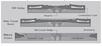
- Process: When divergence occurs within a continent, it can lead to the formation of rift valleys and block mountains. Tensional forces stretch and thin the continental crust, creating large fractures.
- Geological Features:
- Rift Valleys: Formed as the continental crust continues to stretch and thin, eventually leading to the development of a linear valley.
- Block Mountains: As the crust stretches, some sections may remain elevated or be uplifted, forming block mountains along the sides of rift valleys.
- Evolution into Ocean Basins: Over time, continued rifting may progress to the point where a new ocean basin begins to form as the rift valley deepens and widens, eventually allowing seawater to flood in.
- Example: The Afar Rift in Ethiopia is part of the East African Rift system, an active continental rift zone expected to evolve into a new ocean basin. This rifting process is gradually separating the Horn of Africa from the rest of the continent, illustrating how continental divergence can lead to significant geological transformations.
Convergent Plate Boundaries
Convergent plate boundaries are fundamental geological structures where two of Earth’s tectonic plates collide. This process is integral to understanding the dynamic nature of the planet’s lithosphere, influencing various geological phenomena, including mountain formation, volcanic activity, and earthquake occurrences. The interaction at these boundaries is characterized by the subduction of one plate beneath another, a process that significantly alters the Earth’s surface over geologic time scales.
Types of Convergent Plate Boundaries
Convergent plate boundaries are categorized based on the types of colliding plates, each leading to distinct geological outcomes:
- Oceanic-Oceanic Plate Convergence
- Continental-Continental Plate Convergence
- Oceanic-Continental Plate Convergence
Oceanic-Oceanic Plate Convergence
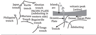
- Mechanism: When two oceanic plates converge, the denser plate subducts beneath the less dense plate, forming a deep trench at the boundary.
- Geological Features:
- Deep Sea Trenches: The subduction zone is marked by a deep trench, such as the Mariana Trench.
- Volcanic Island Arcs: The subducted plate’s material melts, forming magma that rises and solidifies to create volcanic islands, e.g., the Philippines and Indonesia island arcs.
- Significance: This process contributes to the formation of some of the deepest oceanic features and the creation of new landmasses through volcanic activity.
Continental-Continental Plate Convergence
- Mechanism: When two continental plates collide, their similar densities prevent significant subduction, leading to the crumpling and folding of the Earth’s crust.
- Geological Features:
- Fold Mountains: The immense pressure creates fold mountains, such as the Himalayas, formed from the collision of the Eurasian and Indian plates.
- Earthquake Activity: The lack of subduction leads to a buildup of stress, resulting in frequent seismic activity.
- Significance: This type of convergence forms some of the world’s highest mountain ranges and is a key area for studying continental dynamics and earthquake mechanics.
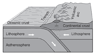
Oceanic-Continental Plate Convergence
- Mechanism: The denser oceanic plate subducts beneath the lighter continental plate, leading to the formation of a trench and volcanic activity along the continental margin.
- Geological Features:
- Trenches: Shallow trenches form at the subduction zone, albeit less deep than those in oceanic-oceanic convergence.
- Volcanic Arcs: Melting of the subducted plate generates magma that rises to form volcanic arcs along the continental margin, as seen in the Andes and the Cascades.
- Significance: This process not only forms significant mountain ranges and volcanic arcs but also plays a critical role in the recycling of the oceanic crust into the mantle.
Geological Impacts and Global Significance
The convergent plate boundaries are crucial in shaping the planet’s geological landscape. They are responsible for:
- Mountain Formation: Creating some of the highest and most impressive mountain ranges on Earth.
- Volcanic Activity: Contributing to the formation of volcanic arcs and islands, which play a key role in the Earth’s geological and biological processes.
- Seismic Activity: Being focal points for earthquakes, these boundaries offer valuable insights into the mechanics of seismic events and their impacts on human societies.
- Convergent plate boundaries exemplify the dynamic nature of Earth’s lithosphere, showcasing the powerful forces at work that mold the planet’s surface. Through the study of these geological phenomena, scientists are able to better understand the processes that have shaped Earth’s landscape over millions of years, providing crucial insights into the planet’s past, present, and future geological evolution.
Transform plate boundaries
Transform plate boundaries represent a unique type of tectonic interaction where the lithospheric plates slide past one another horizontally. This movement can occur in any direction, as long as the plates are moving side-by-side. Unlike divergent (constructive) and convergent (destructive) boundaries, transform boundaries are characterized as conservative because they neither create nor destroy lithospheric crust. The primary feature of transform boundaries is the presence of faults, which are fractures in the Earth’s crust where this lateral movement occurs.
Characteristics of Transform Plate Boundaries
- Lateral Movement: At transform plate boundaries, the movement of tectonic plates is primarily horizontal. This motion can be complex, involving different rates of movement and directions between adjacent plates.
- Conservative Nature: These boundaries are termed “conservative” because the process involved does not contribute to the creation of new crust (as in divergent boundaries) or the destruction/subduction of crust (as in convergent boundaries). Instead, the existing crust is simply displaced.
- Earthquake Activity: Transform boundaries are hotspots for seismic activity. The friction between sliding plates can cause stress to accumulate until it is released suddenly in the form of earthquakes. The intensity and frequency of these earthquakes can vary, but some of the world’s most significant seismic events have occurred along transform faults.
- Lack of Volcanic Activity: Unlike divergent and convergent boundaries, transform boundaries generally lack volcanic activity. This is because there is no upwelling of magma caused by the pulling apart of plates (as at divergent boundaries) or the subduction of one plate beneath another (as at convergent boundaries).
Geological Features Associated with Transform Boundaries
- Faults: The most prominent geological features produced by transform boundaries are faults. These are cracks in the Earth’s crust where significant lateral movement has occurred. Faults can vary in size from a few meters to hundreds of kilometers in length.
- Linear Valleys and Ridges: In some cases, transform boundaries can create linear valleys or underwater ridges as the Earth’s crust is ground down or pushed up by the movement of the plates.
- Offset Features: Rivers, valleys, and other geological features can be offset along transform boundaries. As the plates move past each other, any geographical feature that crosses the boundary can be split and displaced, creating a visible record of the plate movement.
Example: The San Andreas Fault
The San Andreas Fault in California is one of the most studied and well-known examples of a transform plate boundary. Stretching over 1,200 kilometers (about 750 miles), it marks the boundary between the Pacific Plate and the North American Plate. The relative motion of these plates along the fault is responsible for significant seismic activity in the region, including the famous 1906 San Francisco earthquake.
Impact on Human Activities
The seismic activity associated with transform plate boundaries poses significant risks to human populations living in these areas. Earthquakes can lead to loss of life, property damage, and economic disruption. Understanding the mechanics of transform boundaries and monitoring fault lines are crucial for earthquake preparedness and mitigation strategies.
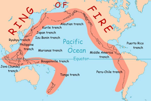
Ring of Fire
Definition and Location
- Also Known As: Circum-Pacific Belt.
- Characteristics: A path along the Pacific Ocean, noted for its high level of seismic activity including active volcanoes and earthquakes.
- Geographical Spread: Encircles the Pacific Plate, touching various continents and countries along its path, including parts of Asia, North America, South America, and Oceania.
Geological Significance
- Plate Tectonics: A prime example of plate tectonic activity, where the Earth’s lithospheric plates meet and interact.
- Convergence Zones: Along much of the Ring of Fire, tectonic plates overlap at convergent boundaries, leading to the formation of deep-sea trenches, volcanic arcs, and volcanic belts.
- Subduction Zones: These areas are where one plate moves under another into the mantle, a process responsible for some of the world’s most powerful earthquakes and volcanic eruptions.
Evidences of Plate Tectonic Theory
Formation of Zealandia
- Overview: Zealandia, also known as the New Zealand continent, is a nearly submerged mass of continental crust that broke away from Antarctica around 100 million years ago (MYA) and from Australia approximately 80 MYA.
- Significance: Its discovery and geological features provide strong evidence of continental drift, a key component of plate tectonic theory.
Axial Seamounts
- Location: Found along the Juan de Fuca Ridge, a divergent plate boundary.
- Characteristics: Axial seamounts are underwater mountains formed by volcanic activity.
- Importance: Serve as a live recording of the process of seafloor spreading, supporting the concept of divergent plate movements where two tectonic plates move away from each other.
2012 Sumatra Earthquake and its Aftermath
- Event Description: A significant earthquake that occurred off the coast of Sumatra, Indonesia.
- Plate Movement: Resulted from the slippage of the Indo-Australian plate, which led to its fragmentation into smaller plates.
- Volcanic Activation: The earthquake’s tectonic activity was further linked to the activation of the Barren Island volcano, demonstrating the interconnectedness of seismic events and volcanic activity within plate tectonic theory.
- The Ring of Fire serves as a dynamic and vivid illustration of plate tectonics in action. From the formation of deep ocean trenches and volcanic arcs to the seismic events that reshape continents, the evidence gathered from around the Ring of Fire and related geological phenomena like Zealandia, axial seamounts, and the effects of large earthquakes provides compelling support for the theory of plate tectonics. These phenomena not only demonstrate the movement and interaction of Earth’s lithospheric plates but also highlight the ongoing nature of geological processes that continue to shape our planet’s surface.
Rate of Plate Movement
Measurement Technique
- Magnetic Stripes Method: The rate of plate movement is inferred from the pattern of normal and reverse magnetic fields recorded along the mid-oceanic ridges. These magnetic stripes serve as a historical record of Earth’s geomagnetic reversals and are symmetrically arranged on either side of the ridges.
- Process: As new oceanic crust is formed at mid-oceanic ridges, iron-rich minerals within the molten rock align with the Earth’s magnetic field. Over time, the Earth’s magnetic field reverses, creating a pattern of magnetic stripes of alternating polarity on the seafloor.
Variability Across Plates
- Differential Rates: The rate at which tectonic plates move varies significantly across different plates and boundaries, ranging from a few millimeters to several centimeters per year.
- Factors Influencing Rate: Several factors contribute to the variability in plate movement rates, including the force of mantle convection, slab pull at subduction zones, and ridge push at divergent boundaries.
Significance of Plate Tectonics
Understanding Geological Phenomena
- Earthquakes and Volcanoes: Plate tectonics provides a framework for understanding the distribution and mechanism of earthquakes and volcanic eruptions. The interaction of tectonic plates at their boundaries is a primary cause of these natural events.
- Predictive Tool: Knowledge of plate movements and interactions aids in predicting the likely locations of future seismic and volcanic activity.
Formation of Geological Features
- Fold Mountains: The collision of tectonic plates at convergent boundaries leads to the formation of fold mountains along continental margins. This process explains the origin of major mountain ranges such as the Himalayas.
- Associated Landforms: Other landforms, such as ocean trenches, volcanic arcs, and rift valleys, are also a direct result of plate tectonic processes.
Exploration and Resources
- Mineral Exploration: Plate tectonics aids in the exploration of new mineral resources. The Ring of Fire, characterized by its volcanic and seismic activity, is also noted for its rich mineral deposits.
- Magma and Minerals: The movement of magma in these regions brings mineral-rich material closer to the Earth’s surface, making it accessible for mining and extraction.
- Economic Significance: Understanding plate tectonics is crucial for the exploration and sustainable exploitation of Earth’s mineral resources, which are vital for various industries and technologies.
Wilson Cycle
The Wilson Cycle, named after the Canadian geophysicist J. Tuzo Wilson, is a fundamental concept in the field of geology and plate tectonics that describes the cyclical opening and closing of ocean basins driven by the movement of Earth’s crustal plates. This cycle outlines the dynamic nature of the Earth’s lithosphere, including the formation, evolution, and eventual closure of oceanic basins, and plays a crucial role in understanding the distribution and movement of continents and oceans over geological time scales.
1. Initiation Stage: Mantle Plume Activity
- Rising of Mantle Plume: The cycle begins deep beneath the Earth’s surface with the ascent of a mantle plume—a column of hot, solid yet plastic-like material rising from the deep mantle. This plume reaches the base of the Earth’s lithosphere (the crust and the uppermost mantle), where its heat causes the overlying lithosphere to warm and become buoyant.
- Thinning of Overlying Crust: As the mantle plume heats the lithosphere, it induces thermal expansion and a reduction in density. This process leads to the thinning of the overlying crust, creating an area of weakness.
2. Rifting and Ocean Basin Formation
- Extensional Tectonic Forces: The thinning crust is subjected to extensional forces, which pull the lithosphere apart. This extension can be driven by the mantle plume itself or by distant tectonic forces transmitted through the lithosphere.
- Formation of Rift Valleys: Initially, the extension leads to the formation of rift valleys, characterized by faulting and volcanic activity. If the extension continues, these rift valleys can deepen and widen.
- Birth of an Ocean Basin: Over time, as the rift widens, it may breach the surface of the ocean, leading to sea water flooding the rift valley and marking the birth of a new ocean basin. Sediments begin to accumulate along the newly formed margins, and new oceanic crust is created at the rift through volcanic activity.
3. Ocean Basin Maturation
- Widening of Ocean Basin: The ocean basin continues to widen as new oceanic crust is formed at the mid-ocean ridge, and the continents on either side drift apart. The basin is filled with oceanic water, and sedimentation continues along its margins.
4. Subduction and Closure
- Subduction Initiation: Eventually, one of the ocean basin’s margins begins to subduct beneath an adjacent tectonic plate. This process is driven by the oceanic lithosphere cooling and becoming denser with age, making it prone to sinking into the mantle at subduction zones.
- Ocean Basin Closure: The subduction process leads to the gradual closure of the ocean basin. The continents previously separated by the ocean basin begin to converge, and the oceanic crust is consumed in the subduction zone.
- Mountain Building: The collision of continental plates can lead to orogeny, or mountain-building events, as exemplified by the Himalayas formed by the collision of the Indian and Eurasian plates.
5. Completion and Renewal
- Continental Collision: If the subduction process completely closes the ocean basin, it may result in the collision of continental masses, leading to the formation of mountain ranges and the welding of landmasses.
- Renewal of the Cycle: Even after the closure of an ocean basin, tectonic forces can initiate the thinning of the lithosphere in a new location, beginning a new Wilson Cycle.
The Wilson Cycle is a dynamic and ongoing process, reflecting the continuous evolution of the Earth’s lithosphere. It not only explains the past distribution of continents and oceans but also provides a framework for predicting future changes in Earth’s surface geology.
MOVEMENT OF INDIAN PLATE
The movement of the Indian Plate is a significant geological event that illustrates the dynamic nature of Earth’s lithosphere. This process, spanning over hundreds of millions of years, has played a crucial role in shaping the geography, climate, and biological diversity of the Indian subcontinent.
Prehistoric Isolation
- Era: Late Paleozoic to Early Mesozoic (Approx. 225 million years ago)
- Event: During this period, the supercontinent Pangaea began to fragment. The Indian Plate, then a large island, was situated off the Australian coast in the Southern Hemisphere. The Tethys Sea, a vast oceanic expanse, separated it from the Eurasian Plate.
Journey Towards the North
- Era: Mesozoic (Approx. 200 million years ago)
- Event: The breakup of Pangaea initiated the northward drift of the Indian Plate. This marked the beginning of its long journey across the Tethys Sea towards the Eurasian Plate.
Accelerated Movement
- Era: Late Jurassic to Early Cretaceous (Approx. 140 million years ago)
- Location: 50°S Latitude
- Event: By this time, the Indian subcontinent had moved significantly northward but was still located in the southern hemisphere, far south of its current position.
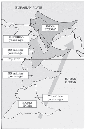
Collision with Eurasian Plate
- Era: Eocene Epoch (Approx. 40-50 million years ago)
- Event: The Indian Plate collided with the Eurasian Plate. This event was monumental, leading to the rapid uplift of the Himalayas. This period marks a significant geological transformation as the Indian Plate, moving at about 15 cm per year, was fast compared to the average tectonic plate movements.
Formation of the Himalayas
- Characteristics: The collision’s force caused the denser and more firmly attached Indian coastline to push into the softer soils of the Asian continent. This interaction led to the compression of these soils into fold mountains, giving rise to the Himalayas.
Continuing Elevation
- Observation: The uplift of the Himalayas continues to this day, with the mountain range rising approximately 1 cm each year. This ongoing process highlights the dynamic nature of Earth’s tectonic activities.
Seismic Activity
- Implication: The constant northward push of the Indian Plate against the Eurasian Plate makes the region prone to frequent earthquakes. These seismic events are a direct consequence of the stresses and strains at the collision boundary.
Volcanic Activity
- Event: As the Indian Plate moved northward, it passed over the Reunion hotspot, leading to significant volcanic activity.
- Outcome: This resulted in the formation of the Deccan Traps, a large volcanic province in present-day India. The event, occurring around 60 million years ago, involved extensive lava flows that covered large parts of the Indian subcontinent.
THEORIES
| Parameter | Continental Drift | Seafloor Spreading | Plate Tectonics |
| Propounded by | Alfred Wegener (1912) | Harry Hess (1960s) | McKenzie, Parker, Morgan (1967-68) |
| Theory | The hypothesis that a single landmass broke apart into pieces which then drifted to form the present continents. | Volcanic activity along the Mid-Oceanic Ridge causes oceanic plates to move and the seafloor to spread from the ridge. | Describes the horizontal movement of lithospheric plates both oceanic and continental crusts over the asthenosphere. |
| Forces of movement | Forces include polar fleeing force, tidal force, and gravitational force. | Driven by convection currents within the Earth’s mantle. | Also driven by convection currents within the mantle. |
| Evidence | Evidence includes the jigsaw fit of continents, polar wandering, matching fossil deposits across continents, placer deposits, and glacial tillites. | Supported by paleomagnetic evidence in rocks, the increasing age of rocks away from the Mid-Oceanic Ridge, and the varying thickness of sediment accumulation. | Evidence comes from paleomagnetic rocks, the occurrence of geophysical phenomena such as earthquakes, volcanoes, and tsunamis. |
| Significance | Laid the foundation for the development of later theories such as seafloor spreading and convection current theories. | Provided a foundation for the development of plate tectonic theory. | Helps in understanding the mechanisms behind earthquakes, volcanic eruptions, the formation of mountain ranges, and other geological phenomena. |
Expansion of Details:
- Continental Drift: Proposed by Alfred Wegener in 1912, this theory suggested that continents are not stationary but move across the Earth’s surface over geological timescales. Wegener’s hypothesis was initially controversial because he could not provide a convincing mechanism for the movement. However, his observations on the matching of continental shorelines, similar rock formations, and fossils across continents were significant contributions to geology.
- Seafloor Spreading: Harry Hess, in the 1960s, proposed that the seafloor spreads apart along mid-ocean ridges, where magma rises from below the Earth’s crust and solidifies to form new oceanic crust. This theory explained the mechanism of continental drift that Wegener couldn’t. Seafloor spreading provided a dynamic picture of how continents could drift apart and was a pivotal step towards the acceptance of plate tectonics.
- Plate Tectonics: The culmination of ideas from both continental drift and seafloor spreading led to the theory of plate tectonics in the late 1960s. This theory describes the Earth’s surface as divided into several large and small plates that move relative to each other. These movements are responsible for most of the significant geological features and activities on Earth, such as earthquakes, volcanic eruptions, and the formation of mountain ranges. The theory of plate tectonics is now the foundational principle in Earth sciences, providing a unifying framework for understanding the past and present dynamics of the planet’s surface.
UPSC PREVIOUS YEAR QUESTIONS
1. Which of the following phenomena might have influenced the evolution of organisms? (2014)
1. Continental drift
2. Glacial cycles
Select the correct answer using the code given below.
(a) 1 only (b) 2 only
(c) Both 1 and 2 (d) Neither 1 nor 2
2.With reference to Ocean Mean Temperature (OMT), which of the following statements is/are correct? (2020)
1. OMT is measured up to a depth of 26°C isotherm which is 129 metres in the south-western Indian Ocean during January–March.
2. OMT collected during January–March can be used in assessing whether the amount of rainfall in monsoon will be less or more than a certain long-term mean.
Select the correct using the code given below:
(a) 1 only (b) 2 only
(c) Both 1 and 2 (d) Neither 1 nor 2
3.With reference to ‘Indian Ocean Dipole (IOD)’ sometimes mentioned in the news while forecasting Indian monsoon, which of the following statements is/are correct? (2017)
1. The IOD phenomenon is characterised by a difference in sea surface temperature between tropical Western Indian Ocean and tropical Eastern Pacific Ocean.
2. An IOD phenomenon can influence an El Nino’s impact on the monsoon.
Select the correct answer using the code given below:
(a)1 only (b) 2 only
(c) Both 1 and 2 (d) Neither 1 nor 2
4.Consider the following factors: (2012)
1. Rotation of the Earth
2. Air pressure and wind
3. Density of ocean water
4. Revolution of the Earth
Which of the above factors influence the ocean currents?
(a) 1 and 2 only (b) 1, 2 and 3
(c) 1 and 4 (d) 2, 3 and 4
5.The most important fishing grounds of the world are found in the regions where: (2013)
(a) Warm and cold atmospheric currents meet
(b) Rivers drain out large amounts of freshwater into the sea
(c) Warm and cold oceanic currents meet
(d) Continental shelf is undulating
6.The acidification of oceans is increasing. Why is this phenomenon a cause of concern: (2012)
1. The growth and survival of calcareous phytoplankton will be adversely affected.
2. The growth and survival of coral reefs will be adversely affected.
3. The survival of some animals that have phytoplanktonic larvae will be adversely affected.
4. The cloud seeding and formation of clouds will be adversely affected.
Which of the statements given above is/are correct?
(a) 1, 2 and 3 only (b) 2 only
(c) 1 and 3 only (d) 1, 2, 3 and 4
7.Consider the following statements about the Andes Mountains:
-
The Andes form the longest continental mountain range in the world.
-
The Andes stretch along the eastern coast of South America.
-
Aconcagua, the highest peak in the Andes, lies in Argentina.
-
The Andes are primarily formed by volcanic activity due to tectonic subduction.
Which of the above statements are correct?
A.
(a) 1, 2 and 3 only
(b) 1, 3 and 4 only
(c) 1 and 4 only
(d) 2, 3 and 4 only