INTERIOR OF THE EARTH
Earth’s Surface Configuration
The Earth’s surface is a dynamic and complex structure, shaped by a multitude of forces and processes that operate both externally and internally. These forces, known as endogenic and exogenic processes, play a pivotal role in sculpting the landscape we inhabit and significantly influence the livelihoods of people around the world.
Endogenic vs. Exogenic Processes
- Endogenic Processes: Originating from within the Earth, endogenic processes are primarily responsible for the formation of mountains, valleys, and various other landforms. These processes include tectonic movements, volcanic activities, and earthquakes, driven by the internal heat of the Earth. The movement of tectonic plates, for instance, can lead to the uplift of mountain ranges or the formation of deep ocean trenches, showcasing the powerful nature of these internal forces.
- Exogenic Processes: In contrast, exogenic processes operate on the Earth’s surface, driven by external forces such as solar energy, atmospheric conditions, and gravity. These processes encompass weathering, erosion, sedimentation, and glaciation, which gradually wear down and reshape the Earth’s surface over time. The action of rivers, wind, and glaciers can carve out valleys, form deserts, and shape coastlines, highlighting the transformative power of nature’s elements.
The Importance of Understanding Earth’s Interior
Delving into the mysteries of the Earth’s interior is crucial for comprehending the geophysical phenomena that impact our planet and, subsequently, our lives. Knowledge of the Earth’s internal composition and the mechanisms at work beneath the surface is key to understanding:
- Earthquakes: Sudden shifts in the Earth’s crust can release immense energy, causing the ground to shake. Understanding the interior helps in identifying fault lines and predicting potential seismic activities.
- Volcanoes: The movement of molten rock, or magma, from beneath the Earth’s crust to its surface leads to volcanic eruptions. Studying the Earth’s interior provides insights into volcanic behavior, aiding in eruption predictions and mitigating disaster impacts.
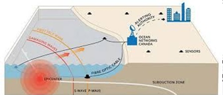
- Tsunamis: Often triggered by undersea earthquakes or volcanic eruptions, tsunamis are massive sea waves that can cause widespread destruction. Knowledge of the Earth’s interior mechanisms allows for the development of early warning systems and preparedness strategies.
Sources of Information
- Understanding the composition of the Earth’s interior is a significant challenge due to the impossibility of accessing its center directly. The Earth’s radius is approximately 6,370 kilometers, making direct observation and sampling of its internal layers beyond human reach. However, scientists have developed various methods to infer the properties of the Earth’s interior, relying on both direct and indirect sources of information. These methods provide valuable insights into the composition, temperature, pressure, and density changes within the Earth.
Direct Sources of Information
- Direct sources of information are invaluable for scientists to understand the composition and structure of the Earth’s interior. Despite the challenge posed by the Earth’s vast size and the impossibility of accessing its center, certain methods allow for the direct study of materials and phenomena related to the Earth’s inner layers. These methods include the analysis of surface solid rocks, drilling and mining operations, and observations of volcanic activity.
Surface Solid Rocks
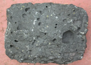
- Volcanic Rocks and Lava: The study of surface rocks, particularly those brought to the surface by volcanic eruptions, offers direct clues about the Earth’s interior. When volcanic rocks and lava solidify on the Earth’s surface, they encapsulate minerals and elements from deeper within the Earth. Analyzing these substances provides insights into the mineral makeup of the Earth beneath its surface. Volcanic materials can reveal the composition of the mantle, from which the magma originates.
Drilling and Mining
- Deep Drilling Operations: To penetrate the Earth’s crust, scientists and engineers employ deep drilling techniques. These operations aim to retrieve rock samples from depths that are otherwise inaccessible. The Kola Superdeep Borehole, for example, reached a depth of approximately 12 kilometers, making it one of the deepest drills into the Earth. These drills reveal the temperature, pressure, and density changes that occur as depth increases, offering a glimpse into the conditions deep within the Earth.
- Mining Operations: The Mponeng and TauTona gold mines in South Africa, among the deepest mines in the world, reach depths of about 3.9 kilometers. Mining operations provide direct access to rock formations deep beneath the surface, allowing scientists to study the geological features and material composition at significant depths.
- Temperature and Pressure Measurements: Through drilling and mining, scientists have determined that temperature increases at a rate of approximately 1°C per 32 meters of depth. These findings are crucial for understanding the thermal gradient of the Earth’s interior and for estimating the conditions in deeper layers.
Volcanic Activity
- Eruption of Molten Material: Volcanic eruptions are a natural source of direct information about the Earth’s interior. The molten material, or magma, that is expelled onto the surface comes from deep within the Earth. By studying this material, scientists can gain insights into the composition of the Earth’s mantle. Although the exact depth of the magma’s source can be uncertain, the chemical and mineralogical composition of volcanic ejecta offers clues about the conditions under which it formed.
- Direct sources of information, such as surface solid rocks, deep drilling and mining operations, and volcanic activity, provide essential data for understanding the Earth’s interior. These methods allow scientists to study the materials and conditions that exist beneath the Earth’s surface, revealing the composition and structure of its crust and upper mantle. Through the analysis of direct evidence, geologists and geophysicists can construct models of the Earth’s internal layers, enhancing our understanding of the planet’s geology and the dynamic processes that shape it.
Indirect Sources of Information
Indirect sources of information are crucial for understanding the composition and state of the Earth’s interior, as they provide insights into its structure without direct material evidence. These sources include physical values, observations of external celestial objects, gravitational anomalies, magnetic fields, and seismic wave behavior. Each of these sources contributes to our understanding of the Earth’s internal composition, structure, and dynamics.
Physical Values
- Temperature, Pressure, and Density: Analyzing these physical properties at various depths allows scientists to infer the material composition of different layers within the Earth. Variations in these values help to identify the transitions between the Earth’s crust, mantle, and core.
External Celestial Objects
- Meteors and Asteroids: Being remnants of the same nebular cloud that formed the Earth, these celestial bodies provide valuable insights into the composition of the early solar system and, by extension, the Earth’s own composition. Studies of meteorite dust and asteroid ash offer clues about the materials that may be present deep within the Earth.
Gravitational Anomaly
- Variations in Gravitational Force: The Earth’s gravity is not uniform; it varies with latitude, being stronger at the poles and weaker at the equator. Furthermore, local variations in gravity can result from the uneven distribution of mass within the Earth. These anomalies in gravity provide indirect evidence of variations in density and composition beneath the Earth’s surface.
Magnetic Field
- Distribution of Magnetic Materials: The Earth’s magnetic field is generated by the movement of molten iron in the outer core. Studying the magnetic field helps scientists understand the distribution of magnetic materials within the Earth and the dynamics of its core.
Seismic Waves
- Seismic waves are critical for understanding the Earth’s internal structure. They are generated by the sudden release of energy along faults and can travel through the Earth’s layers.
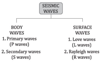
Types of Seismic Waves
Body Waves: These waves travel through the Earth’s interior and are divided into two types:
- P Waves (Primary Waves): Can travel through both liquid and solid layers, indicating the presence of different states of matter within the Earth.
- S Waves (Secondary Waves): Can only travel through solid materials, providing evidence of the Earth’s solid and liquid layers. The absence of S waves in certain areas helps identify liquid layers, such as the outer core.
- Shadow Zones: Created by P and S waves, indicate the presence of layered structures within the Earth.
Surface Waves: Generated at the interface between the Earth’s surface and its interior layers, these waves travel through the crust. They have lower frequencies than body waves and provide information about the Earth’s crustal structure.
Role of Body Waves
- Density Changes: Variations in the velocity of body waves, as they pass through different layers, indicate changes in density and composition.
- Direction Changes: Observations of changes in the direction of P and S waves as they travel through the Earth help scientists map the internal structure and identify different layers.
- Indirect sources of information are indispensable for geoscientists attempting to unravel the mysteries of the Earth’s interior. By analyzing physical properties, gravitational and magnetic anomalies, and the behavior of seismic waves, scientists can construct models of the Earth’s internal structure. This knowledge is crucial for understanding not only the Earth’s composition but also the dynamic processes that drive phenomena such as earthquakes, volcanic eruptions, and plate tectonics.
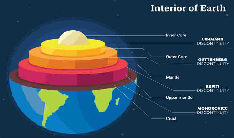
Earth’s Interior
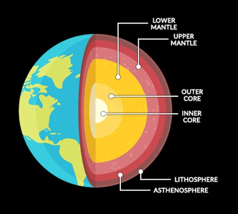
The Earth’s interior is a complex structure composed of distinct layers, each characterized by its unique composition, properties, and functions within the Earth system. Understanding these layers is crucial for geologists, geophysicists, and other Earth scientists as they seek to explain various geological phenomena, including earthquakes, volcanic activity, and plate tectonics.
Crust
Composition and Variability
- Oceanic vs. Continental: The crust is not uniform; it consists of the denser, basaltic oceanic crust and the less dense, granitic continental crust. This dichotomy influences the behavior of tectonic plates, including their buoyancy and movement.
- Tectonic Activity: The crust is the primary location for tectonic activity, including earthquakes and volcanic eruptions. These events occur due to the movement of Earth’s plates and are more frequent at the boundaries where plates interact.
Scientific Significance
- Study of Rocks: The crust provides valuable information about Earth’s history through the study of rocks and minerals, offering clues about past climatic conditions, life forms, and geological events.
- Resource Depot: It is a source of essential resources, such as minerals, fossil fuels, and water, crucial for human civilization and technological advancement.
Mantle
Composition and Dynamics
- Silicate Materials: The mantle is composed of silicate minerals rich in magnesium and iron, which contribute to its density and viscosity.
- Convection Currents: Heat from the core and the mantle itself generates convection currents. These currents drive the movement of the Earth’s lithospheric plates, a fundamental aspect of plate tectonics.
Scientific Significance
- Plate Tectonics Theory: Understanding mantle dynamics is critical for the plate tectonics theory, explaining the formation of mountains, the occurrence of earthquakes, and the distribution of continents and oceans.
- Earth’s Thermal Evolution: The mantle plays a crucial role in Earth’s thermal evolution, acting as a thermal blanket that slowly releases heat from the Earth’s interior to the surface.
Core
Composition and Structure
- Iron-Nickel Alloy: The core is primarily made up of iron and nickel, with the outer core being liquid and the inner core solid due to immense pressure.
- Geodynamo Effect: The movement of the liquid outer core generates the Earth’s magnetic field through the geodynamo effect. This magnetic field is vital for protecting the planet from solar radiation and maintaining the atmosphere.
Scientific Significance
- Magnetic Field Studies: Research on the core and the geodynamo provides insights into the behavior of Earth’s magnetic field, including reversals and fluctuations that have occurred throughout geological history.
- Inner Earth Processes: Understanding the core helps scientists infer the conditions and processes occurring deep within the Earth, which are otherwise inaccessible for direct observation.
Integrative Perspectives on Earth’s Interior
- Interconnected Systems: The Earth’s interior layers are not isolated; they interact in complex ways. For example, mantle convection influences tectonic plate movements, which in turn can affect crustal features and processes. Similarly, core dynamics are essential for generating the magnetic field that shields the Earth.
- Geological and Geophysical Studies: Advanced technologies, such as seismic tomography and magnetic field mapping, allow scientists to study these layers in unprecedented detail, leading to new discoveries about the Earth’s interior.
- Implications for Life on Earth: Understanding the Earth’s interior is crucial for comprehending the planet’s habitability. The magnetic field protects life from harmful solar radiation, while plate tectonics play a role in climate regulation and the recycling of carbon through the carbon-silicate cycle.
Geomagnetic Field
The geomagnetic field is a fundamental and dynamic component of our planet, reflecting complex interactions within the Earth’s interior.
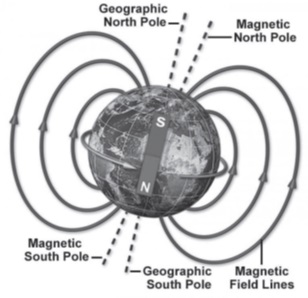
- Geomagnetic Field: This term refers to the Earth’s magnetic field, which extends from the Earth’s interior into space, where it meets the solar wind, a stream of charged particles emanating from the Sun. This field is akin to a gigantic bar magnet tilted at an angle from the Earth’s rotational axis.
Characteristics
- Magnetic Dipole Tilt: The Earth’s magnetic field is not aligned perfectly with the planet’s rotational axis. Instead, the magnetic dipole, which can be thought of as a bar magnet placed at the center of the Earth, is tilted at an angle of approximately 11°. This misalignment causes the magnetic north and south poles to be located at different positions from the geographic poles.
- Dynamic Nature: The geomagnetic field is not static; it changes over time and varies depending on location. These variations can be short-term, such as daily fluctuations, or long-term, including gradual shifts in the magnetic poles and reversals of the magnetic field.
- Intensity Variation: The strength of the magnetic field is not uniform across the Earth’s surface. It is stronger at the poles and weaker at the equator. This gradient in intensity is due to the geometric configuration of the field lines, which are denser at the poles.
Significance
- Understanding the Earth’s Interior: Studying the geomagnetic field provides valuable insights into the Earth’s core, particularly the metallic, liquid outer core. The behavior and changes in the magnetic field offer clues about the processes occurring deep within the Earth.
Causes
The generation and maintenance of the geomagnetic field are attributed to several interrelated processes in the Earth’s outer core:
- Motion of the Outer Core: The Earth’s outer core is composed of molten iron alloy. Its movement is primarily driven by the planet’s rotation and convection currents within the core. This motion is a critical factor in generating the Earth’s magnetic field.
- Convection Currents: Differences in temperature, pressure, and composition within the outer core create convection currents. These currents of molten metal move in a turbulent, yet organized manner, contributing to the generation of the magnetic field.
- Dynamo Effect: The core’s movement and the convection currents facilitate the dynamo effect. This phenomenon occurs when the flow of electrically conductive fluid, such as the liquid iron in the Earth’s outer core, generates and maintains a magnetic field. The dynamo effect is the primary reason for the existence of the Earth’s geomagnetic field.
Magnetic Equator
- Definition: The magnetic equator is an imaginary line encircling the Earth, parallel to the geographical equator. It is the locus where the magnetic field of the Earth is perfectly horizontal, meaning that a freely suspended magnetic needle would show no dip, i.e., it aligns horizontally without tilting towards the Earth’s surface.
- Significance: In Thumba, Kerala (India), for instance, the magnetic equator passes through, showcasing the global nature of this magnetic phenomenon and its influence on local magnetic observations.
Magnetic Declination
- Definition: Magnetic declination refers to the angle between geographic true north (geographic pole) and the magnetic north (the direction a compass needle points). It is a crucial factor in navigation and compass use, as it varies by location and over time.
- Positive and Negative Declination: If the magnetic north is east of geographic true north, the declination is considered positive. Conversely, if it’s west, the declination is negative. This distinction is vital for accurately determining directions across different regions of the Earth.
Magnetic North Pole
- Definition: The Magnetic North Pole is a point in the Northern Hemisphere where the Earth’s magnetic field points directly downwards (vertical). At this location, the magnetic dip angle is 90°, indicating that a freely suspended magnetic needle would point straight down.
- Variability: The position of the Magnetic North Pole is not fixed; it shifts over time due to changes in the Earth’s magnetic field, influenced by the dynamo processes in the Earth’s core.
Magnetic South Pole
- Definition: Similar to its northern counterpart, the Magnetic South Pole is located in the Southern Hemisphere, where the magnetic field is oriented vertically upwards. Here, a magnetic needle would point straight up, indicating a magnetic dip of -90°.
- Variability: The Magnetic South Pole also moves due to the dynamical processes within the Earth’s core, mirroring changes similar to those affecting the Magnetic North Pole.
Geomagnetic Poles
- Definition: The geomagnetic poles refer to the two points on the Earth’s surface where the axis of an idealized dipole best fitting the Earth’s magnetic field intersects the Earth. This model simplifies the Earth’s magnetic field to resemble that of a giant bar magnet.
- Difference from Magnetic Poles: Unlike the magnetic poles, which are defined by the field’s vertical direction, the geomagnetic poles are determined by the theoretical axis of a dipole model. They are relatively stable compared to the magnetic poles but still subject to long-term changes as the Earth’s magnetic field evolves.
These terminologies are essential for understanding the complexity and variability of the Earth’s magnetic field. They play critical roles in navigation, geomagnetic studies, and understanding the Earth’s interior and its dynamic processes.
The Earth’s geomagnetic field is not just a fascinating aspect of our planet’s physical makeup; it plays several crucial roles that affect both the natural world and human activities. Let’s explore its significance in detail:
Protection Against Solar Winds
- Solar Winds: These are streams of charged particles, including electrons and protons, emitted by the Sun. Without the Earth’s geomagnetic field, these particles could strip away the Earth’s atmosphere and cause significant damage to life by directly exposing the surface to harmful solar radiation.
- Shielding Effect: The geomagnetic field acts as a protective shield, deflecting solar winds and preventing them from reaching the Earth’s surface. This defense mechanism is vital for preserving the atmosphere and protecting biological life from solar and cosmic radiation.
- Polar Lights: When solar winds do penetrate the Earth’s magnetic shield, they interact with particles in the Earth’s atmosphere, causing phenomena such as the Aurora Borealis (Northern Lights) and Aurora Australis (Southern Lights). These displays are not only beautiful but also serve as a visual representation of the dynamic interactions between solar winds and the Earth’s magnetic field.
Navigation
- Compass Use: For centuries, humans have used the Earth’s magnetic field for navigation. A compass, which aligns itself with the geomagnetic field, points towards the magnetic north, providing a stable reference direction that is crucial for navigation on land and at sea.
- Animal Migration: Many species of animals, including birds, sea turtles, and bees, possess a sense of magneto-perception, allowing them to detect the Earth’s magnetic field and use it to navigate during long-distance migrations. This innate ability highlights the geomagnetic field’s role in the natural behavior and survival of various species.
Paleomagnetic Studies
- Past Geomagnetic Records: By studying the remnant magnetism in rocks, scientists can understand the history of the Earth’s geomagnetic field. This field of study, known as paleomagnetism, provides insights into how the field has changed over millions of years.
- Age of Rocks: Paleomagnetic studies also help determine the age of rocks, contributing to our understanding of geological time scales and the history of the Earth’s crust.
- Seafloor Spreading and Plate Tectonics: The patterns of magnetic stripes on the ocean floor, discovered through paleomagnetic studies, were key evidence for the theories of seafloor spreading and plate tectonics. These theories revolutionized our understanding of Earth’s geological processes, including earthquakes, volcanic activity, and mountain formation.
Creation of Magnetosphere
- Magnetosphere Formation: The geomagnetic field extends far into space, creating a vast region called the magnetosphere. This region is shaped by the interaction of the geomagnetic field with solar winds and protects the Earth from the majority of the Sun’s charged particles.
- Importance: The magnetosphere plays a critical role in protecting Earth’s satellites and space stations from solar radiation, ensuring the safety of astronauts and the functionality of space-based technology, including communication and weather satellites.
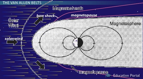
Magnetosphere
The magnetosphere is a critical component of Earth’s natural defense system, playing a significant role in maintaining the planet’s habitability by protecting it from the harmful effects of solar and cosmic radiation.
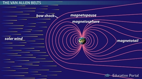
- Definition and Function
- The magnetosphere is a region of space surrounding the Earth that is dominated by the Earth’s magnetic field. It acts as a shield against electrically charged particles, primarily from the solar wind—a stream of charged particles (plasma) released from the upper atmosphere of the Sun.
- Lorentz Force
- Lorentz force plays a pivotal role in the dynamics of the magnetosphere. It is the force experienced by charged particles when they move through a magnetic field, acting at a right angle to the direction of both the magnetic field lines and the motion of the particles. This force deflects the path of charged particles, preventing most of them from reaching the Earth’s surface.
- Structure of the Earth’s Magnetosphere
- The Earth behaves like a giant bar magnet with magnetic field lines emerging near the geographic South Pole, extending into space, and converging again near the geographic North Pole. This invisible field is what forms the magnetosphere.
- The boundary of the magnetosphere is called the magnetopause, which separates the Earth’s magnetic field from the solar wind.
- Outside the magnetopause lies the magneto-sheath, a region of turbulent magnetic field affected by the solar wind.
- Within the magnetosphere is the Van Allen radiation belt, a zone containing high-energy charged particles trapped by the Earth’s magnetic field.
Magnetosphere’s Role in Making Earth Habitable
- Protection from Solar and Cosmic Radiation
- The magnetosphere acts as a protective shield for life on Earth. It blocks and deflects the harmful solar and cosmic radiation that could damage the DNA of living organisms, leading to mutations or lethal outcomes.
- Prevention of Atmospheric Erosion
- Another critical function of the magnetosphere is to prevent the solar wind from stripping away the Earth’s atmosphere. Without this protection, the atmosphere could be gradually eroded by the solar wind, leading to a significant loss of water and other volatile compounds essential for life.
- Sustaining Life
- The existence and evolution of life on Earth have been significantly influenced by the magnetosphere. By protecting the planet from harmful radiation and preserving the atmosphere, the magnetosphere has created and maintained conditions suitable for life to develop and thrive.
Magnetic storms
Magnetic storms, also known as geomagnetic storms, are periods of significant disturbance in the Earth’s magnetosphere that are caused by interactions between the Earth’s magnetic field and solar wind. These events are fascinating phenomena that intertwine space weather with terrestrial effects.
Formation of Magnetic Storms
Magnetic storms are initiated by sudden gusts of solar wind, which are streams of charged particles emitted by the Sun. These gusts can be especially intense following solar flares or coronal mass ejections (CMEs) from the Sun. When these charged particles reach the Earth, they can collide with the magnetosphere, the region around the Earth dominated by the Earth’s magnetic field.
Interaction with the Magnetosphere
The magnetosphere acts as a shield, protecting the Earth from the solar wind. However, when the solar wind is particularly strong, it can compress the magnetosphere and induce changes in the Earth’s magnetic field. This interaction causes the rapid magnetic field variations characteristic of magnetic storms.
Generation of Ring Currents
One of the key features of magnetic storms is the generation of ring currents. These are electric currents that flow in the near-Earth space, predominantly concentrated over the equator. The ring currents are generated by the movement of charged particles in the Earth’s magnetosphere, driven by the disturbed conditions of the magnetic storm.
Impact on the Earth’s Magnetic Field
The flow of these currents can cause a temporary decrease in the Earth’s magnetic field, a phenomenon known as a geomagnetic depression. The strength and duration of the ring currents can vary, influencing the severity of the magnetic storm.
Impacts of Magnetic Storms
Magnetic storms can have a variety of impacts on Earth, affecting both technology and the natural world.
GPS and Radio Communications
One of the most notable effects of magnetic storms is the disturbance to GPS and radio communications. The ionosphere, a layer of the Earth’s atmosphere that reflects and modifies radio waves, is affected by the changes in the Earth’s magnetic field. This can lead to GPS signal errors and disruptions in radio communications, affecting navigation and communication systems.
Other Impacts
In addition to technological disruptions, magnetic storms can also have other effects, such as:
- Auroras: The charged particles from the solar wind can enter the Earth’s atmosphere near the poles, causing the beautiful light displays known as the aurora borealis (northern lights) and aurora australis (southern lights).
- Electrical Grids: Large geomagnetic induced currents (GICs) can flow through power lines, potentially damaging transformers and other components of electrical grids.
- Satellite Operations: Satellites in orbit can be affected by the increased radiation and charged particle environment, potentially leading to malfunctions or damage.
Earthquakes
Earthquakes
An earthquake is a significant geophysical event characterized by the abrupt motion or tremors of the Earth’s surface. This phenomenon results from the sudden release of energy that has been gradually accumulating over time within the Earth’s crust. The energy is released in the form of seismic waves, which propagate along faults or fractures in the Earth’s crust.
Earthquake Risk in India
India is a country with a high risk of earthquakes, highlighting the importance of preparedness and mitigation strategies. Approximately 59% of India’s land area is susceptible to moderate to severe earthquake activities. This vulnerability underscores the need for robust earthquake-resistant infrastructure and effective emergency response mechanisms.
Key Concepts in Earthquake Science
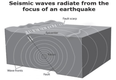
- Focus and Epicenter: The focus of an earthquake is the point within the Earth where seismic waves originate. It lies beneath the Earth’s surface, at varying depths. Directly above the focus, on the Earth’s surface, is the epicenter, which is often the location experiencing the most intense shaking.
- Seismic Waves: Seismic waves are energy waves that spread out from the earthquake’s focus in all directions. They are the primary reason for the shaking felt during an earthquake.
Phenomenon of Foreshocks, Mainshocks, and Aftershocks
- Foreshocks are smaller tremors that precede the main earthquake event, known as the mainshock. They occur in the same region and can serve as a warning sign of a larger seismic event to follow.
- Aftershocks are smaller earthquakes that occur in the aftermath of a mainshock in the same area. They can continue over days, weeks, or even months, gradually decreasing in intensity.
- An example of this sequence was observed on August 14, 2021, in Haiti, where a devastating 7.2 magnitude earthquake resulted in over 2,000 fatalities.
Classification Based on Focus Depth
Earthquakes are categorized based on the depth of their focus:
- Shallow focus earthquakes occur at depths of 0 – 70 km. They tend to be more destructive due to their proximity to the Earth’s surface.
- Intermediate focus earthquakes have their focus at depths between 70 – 300 km. These are often caused by the pressure exerted on a subducting plate due to convection movements in the asthenosphere.
- Deep focus earthquakes occur at depths of 300 – 700 km. While they can be felt over larger distances, they typically cause less surface damage compared to shallow focus earthquakes.

Energy Distribution in Earthquakes
The distribution of energy released by earthquakes varies by depth:
- Shallow focus earthquakes account for approximately 70-85% of the total energy released by earthquakes, making them significantly more impactful.
- Intermediate focus earthquakes contribute about 12-15% of the total energy.
- Deep focus earthquakes, despite their potential to be felt over vast distances, only account for about 3-5% of the total energy release.
Measurement and Recording of Earthquakes
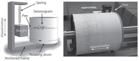
- Seismographs and Seismograms
- Seismographs are the primary instruments used to detect and record earthquakes. These devices are sensitive to the vibrations caused by seismic waves traveling through the Earth’s crust.
- The record produced by a seismograph is known as a seismogram. Seismograms display the amplitude and frequency of seismic waves, providing valuable data for analyzing the characteristics of an earthquake.
- Measuring Earthquake Magnitude
- Magnitude quantifies the amount of energy released by an earthquake. This measurement is crucial for understanding the size and potential impact of an earthquake.
- The Richter Scale is traditionally used to measure magnitude. It is a logarithmic scale, meaning that each whole number increase represents a tenfold increase in the amplitude of the seismic waves and roughly 31 times more energy release.
- For example, an earthquake with a magnitude of 7.5 on the Richter scale releases approximately 30 times more energy than one with a magnitude of 6.5.
- The Richter scale is most effective for earthquakes with magnitudes between 1 and 8.
- The Moment Magnitude Scale is another method used to measure the magnitude of earthquakes, particularly those with a magnitude greater than 8. It provides a more accurate representation of an earthquake’s size by incorporating more variables than the Richter Scale.
- Understanding Earthquake Intensity
- Intensity measures the effects or severity of an earthquake in a specific location. Unlike magnitude, which is a measure of energy released at the source of the earthquake, intensity varies from place to place.
- The Mercalli Intensity Scale is used to assess earthquake intensity. This scale ranges from 1 to 12, with 12 indicating total destruction. It considers the damage caused by the earthquake, people’s reactions, and changes in natural objects.
- Isoseismal Lines are contours that connect points of equal intensity. They are used to map the intensity distribution of an earthquake across affected areas.
- The Meizoseismal Area refers to the region experiencing the strongest shaking and, consequently, the most significant damage. This area is often located near the earthquake’s epicenter.
Seismic Waves
Seismic waves are a fundamental concept in the study of geophysics, particularly in understanding earthquakes and the Earth’s internal structure.
Definition and Origin
Seismic waves are waves of energy that travel through the Earth’s layers, caused by the sudden release of energy in the Earth’s crust. This energy release can occur due to various reasons, including tectonic movements, volcanic eruptions, large landslides, and significant human-made explosions. When the Earth’s tectonic plates shift suddenly, they release a massive amount of energy, creating seismic waves that propagate in all directions from the source of the disturbance.
Importance
- Geological Phenomena: Seismic waves are primarily known for their role in causing earthquakes. However, their impact extends to other geological phenomena such as volcanic eruptions and large landslides. These waves are a key indicator of the dynamic processes occurring within the Earth’s crust and mantle.
- Earth’s Interior Exploration: Beyond their destructive capabilities, seismic waves are invaluable tools for geoscientists. By analyzing how these waves travel through the Earth and are reflected or refracted by different layers, scientists can infer the composition, density, and physical state of those layers. This method, known as seismic tomography, is akin to taking an ultrasound of the Earth’s interior.
Classification of Seismic Waves
Seismic waves are categorized into two main types based on how they travel through the Earth: Body waves and Surface waves.
Body Waves
Body waves propagate through the interior of the Earth and are further divided into two types:
- P-Waves (Primary Waves): These are the fastest seismic waves and the first to be detected by seismographs. P-waves are compressional waves, meaning they cause particles in the Earth to move back and forth in the same direction as the wave is traveling. They can move through both solid and liquid layers of the Earth.
- S-Waves (Secondary Waves): Following P-waves, S-waves are slower and arrive next on seismographs. These are shear waves, causing particles to move perpendicular to the direction of wave propagation. S-waves can only travel through solids, which is a crucial characteristic used to deduce the liquid nature of the Earth’s outer core.
Surface Waves
Surface waves travel along the Earth’s surface and tend to be slower than body waves. However, they are usually responsible for the most damage during an earthquake because their amplitude is larger near the Earth’s surface. Surface waves are divided into two main types:
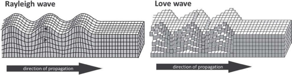
- Love Waves: These waves cause the ground to move horizontally in a shear motion, perpendicular to the direction of wave propagation. They are named after A.E.H. Love, a British mathematician who first described them.
- Rayleigh Waves: Named after Lord Rayleigh, who theoretically predicted their existence, these waves cause the ground to move in an elliptical motion, similar to the movement of ocean waves. Rayleigh waves can be particularly damaging to structures due to their rolling motion.
Body Waves
Body waves are a fundamental concept in seismology, relating to the propagation of seismic energy through the Earth’s interior. These waves are generated by the sudden release of energy at the Earth’s focus, often due to geological events like earthquakes. As they travel through the Earth, their velocity and direction are influenced by the material properties they encounter, particularly the density of the medium. A key characteristic of body waves is their ability to travel through the entire body of the Earth, distinguishing them from surface waves, which are confined to the Earth’s exterior layers.
P-Waves and S-Waves
Body waves are categorized into two main types: P-waves (Primary waves) and S-waves (Secondary waves), each with distinct properties.
P-Waves (Primary Waves)
- Nature and Propagation: P-waves are longitudinal or compressional waves, where the particle displacement is parallel to the wave’s direction of propagation. This can occur in the same or opposite direction of the wave movement.
Characteristics:
- They are the fastest type of seismic waves and thus are the first to be detected by seismic stations following an earthquake.
- P-waves can propagate through all states of matter: solids, liquids, and gases. In solids, they cause particles to move back and forth in the direction of the wave propagation, leading to regions of compression and rarefaction.
- They are also referred to as pressure waves due to their ability to cause fluctuations in pressure within the medium they travel through.
- The velocity of P-waves varies according to the medium, being fastest in solids and slowest in gases.
- Implications: The ability of P-waves to travel through both solid and liquid layers of the Earth is crucial for understanding the Earth’s internal structure.
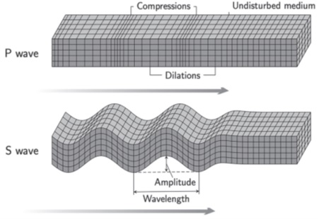
S-Waves (Secondary Waves)
- Nature and Propagation: S-waves are transverse waves, meaning the particle displacement is perpendicular to the direction of wave propagation. This movement is similar to the ripples observed on the surface of water.
Characteristics:
- S-waves are slower than P-waves and can only propagate through solids. This limitation is due to the requirement for a medium that can withstand shear stress, which liquids and gases cannot.
- The motion caused by S-waves is perpendicular to the wave’s direction, causing particles to move up and down.
- Implications: The inability of S-waves to travel through liquids provides key evidence for the liquid state of the Earth’s outer core.
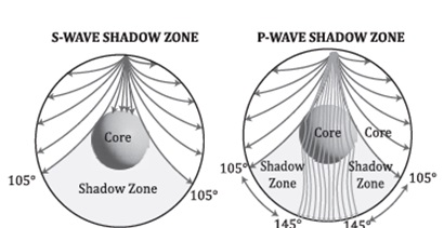
Shadow Zones of Body Waves
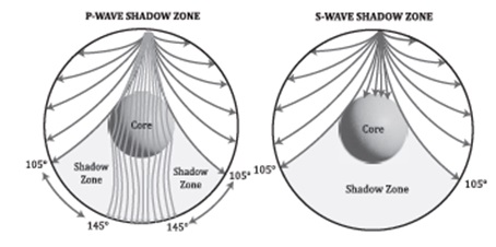
- Observations and Definitions: Shadow zones are regions on the Earth’s surface where seismic waves from a particular earthquake are not detected by seismographs. The shadow zone for S-waves is larger than that for P-waves, extending beyond 105° from the earthquake’s epicenter, where no S-waves are detected.
- Formation: The shadow zones are a direct consequence of the Earth’s internal structure and the properties of P-waves and S-waves.
- S-Waves: Their shadow zone is formed because S-waves cannot travel through the liquid outer core, effectively being stopped.
- P-Waves: Although P-waves can traverse both solid and liquid mediums, their paths are refracted (bent) when transitioning between materials of different densities, such as entering the liquid outer core. This refraction leads to a P-wave shadow zone, where the waves are deflected away from certain areas on the Earth’s surface.
Surface Waves
Surface waves are a significant component of seismic events, playing a pivotal role in the aftermath of earthquakes. These waves emerge following the initial body waves (P and S waves) as they reach the Earth’s surface. Their unique characteristics and behaviors differentiate them from other seismic waves, underlining their importance in the study of geophysics and earthquake engineering.
Definition and Characteristics
- Origin: Surface waves are generated after body waves (P and S waves) interact with the Earth’s surface. Unlike body waves that travel through the Earth’s interior, surface waves propagate along the surface.
- Impact: They are notorious for their destructive potential. As surface waves travel, they displace rocks and the Earth’s crust, leading to significant structural damage and collapses. This destruction is primarily because these waves release energy over the Earth’s surface, affecting buildings and structures directly.
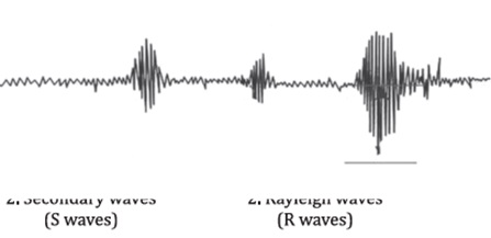
- Detection: Surface waves are the last to be recorded on seismographs during an earthquake. Despite their late arrival, the magnitude of their impact is substantial, often accounting for the prolonged shaking felt during seismic events.
Types of Surface Waves
Surface waves are classified into two main types, each with distinct properties and effects:
1. Raleigh Waves (R Waves)
- Analogy: R waves are similar to water waves. They propagate in a rolling motion, reminiscent of waves traversing across a lake or ocean surface.
- Effects: These waves are responsible for most of the shaking felt during an earthquake. Their rolling motion can cause significant vertical and horizontal ground movement, leading to severe damage to structures and the Earth’s surface.
2. Love Waves (L Waves)
- Speed: L waves are recognized as the fastest among surface waves. Their speed allows them to arrive sooner than R waves but after P and S waves.
- Movement: They induce movement in the ground that is horizontal and perpendicular to the wave’s direction of travel. This specific movement pattern can be exceptionally destructive, especially to the foundations and lower structures of buildings.
- Confinement: Their effects are primarily confined to the Earth’s crust, concentrating their energy and potential for damage at the surface.
Sequence of Seismic Wave Arrival
The sequence in which seismic waves arrive at a monitoring station is crucial for understanding the dynamics of an earthquake. The typical order of arrival is:
- P Waves (Primary Waves): The fastest waves, traveling through solids, liquids, and gases.
- S Waves (Secondary Waves): Slower than P waves, these can only move through solids.
- L Waves (Love Waves): The fastest surface waves, arriving before R waves.
- R Waves (Raleigh Waves): The last to arrive, known for their rolling motion and significant contribution to the earthquake’s destructive power.
Understanding surface waves is essential for seismologists and engineers alike, as these waves play a critical role in the damage and effects felt during and after an earthquake. By studying their properties, origins, and behaviors, researchers can better predict the potential impact of seismic events and develop more effective strategies for building resilient structures.
Determining the epicenter of an earthquake is a critical process in seismology, the study of earthquakes and seismic waves that move through and around the Earth. This process involves analyzing seismic waves recorded by seismographs to pinpoint the location of the earthquake’s source.
Seismic Waves: P-waves and S-waves
P-waves (Primary Waves)
- P-waves, or primary waves, are the fastest type of seismic wave and the first to arrive at a seismographic station following an earthquake. They can move through both solid and liquid layers of the Earth, propagating by compressing and expanding the material in the same direction that the wave is traveling.
S-waves (Secondary Waves)
- S-waves, or secondary waves, arrive at a seismographic station after the P-waves. They are slower than P-waves and can only move through solid materials. S-waves move material perpendicular to the direction of wave propagation, causing a shearing effect.
Determining the Epicenter
Recording Time and S-P Interval
- When an earthquake occurs, it generates both P-waves and S-waves that travel through the Earth’s interior. These waves are recorded by seismographs stationed at various locations around the world.
- The S-P interval is the difference in arrival times of the S-wave and P-wave at a seismographic station. This interval is crucial because it increases with the distance from the earthquake’s epicenter.
Calculating Distance to the Epicenter
- The S-P interval is used to calculate the distance to the epicenter. Seismologists have developed charts that correlate S-P intervals to distances. Essentially, the longer the S-P interval, the greater the distance to the epicenter.
Triangulation Method
- To pinpoint the epicenter, data from at least three seismographic stations are needed. Each station’s data allows seismologists to draw a circle on a map with a radius equal to the calculated distance from the station to the epicenter.
- The point where all three circles intersect is the location of the epicenter. This process is known as triangulation.
Importance of Determining the Epicenter
- Emergency Response: Quickly locating the epicenter helps direct emergency response and relief efforts to the areas most affected by the earthquake.
- Scientific Research: Understanding the epicenter’s location contributes to research on tectonic activity and helps refine models of the Earth’s interior.
- Building Codes and Infrastructure Planning: Knowledge of earthquake patterns and epicenters informs the development of building codes and infrastructure planning to mitigate damage in earthquake-prone regions.
Seismic waves, generated by earthquakes or artificial sources, are invaluable tools for probing the Earth’s interior. Their propagation through the Earth provides essential clues about the structure, composition, and dynamic processes occurring beneath the surface. This process involves analyzing how these waves are reflected, refracted, and absorbed by different layers within the Earth.
Shadow Zones of Body Waves
Body waves, which include P-waves (primary waves) and S-waves (secondary waves), penetrate the Earth’s interior and can be recorded at distant locations. However, there are areas on the Earth’s surface where these waves are not detected after an earthquake, known as “shadow zones.” These zones provide critical information about the Earth’s internal structure.
- P-Waves: P-waves are compressional waves that can travel through solids, liquids, and gases. The presence of a shadow zone for P-waves at certain angles from the earthquake epicenter suggests that these waves are refracted by the core-mantle boundary. This refraction indicates a drastic change in density and composition between the mantle and the core.
- S-Waves: S-waves, being shear waves, can only travel through solids. The fact that S-waves do not reach certain areas on the Earth’s surface (creating a larger shadow zone than that of P-waves) indicates that the outer core is liquid. S-waves are stopped by the liquid outer core, providing direct evidence of its fluid state.
Discontinuity in Velocity
The speed at which seismic waves travel depends on the density and elasticity of the materials they pass through. A sudden change in the velocity of these waves, known as a seismic discontinuity, suggests a change in composition or phase of the material.
- Velocity-Density Relationship: Generally, waves travel faster through denser, more elastic materials. By measuring the travel times of seismic waves at various depths, scientists can infer changes in the Earth’s composition and density.
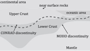
- Major Discontinuities: Several discontinuities, such as the Mohorovičić discontinuity (the Moho), which marks the boundary between the Earth’s crust and mantle, and the boundaries between the upper mantle, lower mantle, and outer core, have been identified through seismic wave analysis.
Changes in Phases
Seismic waves also undergo phase changes as they encounter different materials. These phase changes, coupled with velocity discontinuities, help in identifying transitions between different states of matter (e.g., from solid to liquid) or changes in mineral composition.
- Refraction and Reflection: As seismic waves travel through the Earth, they are refracted (bent) and reflected at boundaries between different materials. By analyzing these changes in direction, scientists can infer the presence of different layers and their properties.
Wadati–Benioff Zone
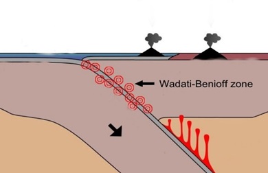
The Wadati–Benioff zone represents a crucial concept in the study of plate tectonics and seismology. It is named after seismologists Kiyoo Wadati and Hugo Benioff, who independently discovered these zones. A Wadati–Benioff zone is an area where a dense oceanic plate converges with a less dense continental plate, leading to the subduction of the oceanic plate beneath the continental plate. This process forms a sloping zone of seismicity extending from the oceanic trench downward into the Earth’s mantle.
Characteristics of Wadati–Benioff Zones
- Subduction Phenomenon: The essence of a Wadati–Benioff zone is the subduction process. Subduction zones are pivotal in understanding the recycling of the Earth’s crust. As the oceanic plate is forced under the continental plate, it sinks into the mantle due to its higher density.
- Seismic Activity: These zones are synonymous with intense seismic activity, including some of the deepest and most powerful earthquakes recorded. The earthquakes in Wadati–Benioff zones can occur at depths of up to 700 kilometers below the Earth’s surface.
- Mechanism of Earthquake Generation: Earthquakes in the Wadati–Benioff zone can be triggered by two primary mechanisms:
- Subduction Thrust Fault: Many earthquakes are generated by the movement along the subduction thrust fault, where the oceanic plate begins its descent into the mantle beneath the continental plate. The friction and locking between the two plates lead to stress accumulation, which, when released, causes significant earthquakes.
- Faults within the Subducting Plate: As the oceanic plate subducts, it is subject to increasing pressure and temperature, which can cause it to deform and fracture. Earthquakes can also occur within the subducting plate itself, caused by these deformations and adjustments as the plate is pulled deeper into the mantle.
Implications of Wadati–Benioff Zones
- Understanding Earth’s Interior: The study of earthquakes within Wadati–Benioff zones provides valuable insights into the processes occurring deep within the Earth’s crust and mantle. By analyzing the seismic waves generated by these earthquakes, scientists can infer the properties of Earth’s internal materials and structures.
- Natural Hazard Assessment: Recognizing and monitoring Wadati–Benioff zones are crucial for assessing the risk of major earthquakes in subduction zones. This knowledge helps in disaster preparedness and mitigation efforts in regions prone to seismic hazards.
- Plate Tectonics Insight: Wadati–Benioff zones are key features in the theory of plate tectonics. They illustrate the dynamic nature of the Earth’s lithosphere, showcasing the ongoing process of plate convergence, subduction, and the cycle of rock through the mantle.
Types and Causes of Earthquake
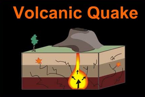
Volcanic Earthquake
- Description: These earthquakes are directly associated with volcanic activity. They typically occur near the Earth’s surface and are a result of the movement of magma within volcanoes, which can create intense pressure and lead to seismic activity.
- Example: The Cotopaxi earthquake in 2002, associated with the Cotopaxi stratovolcano in the Andes Mountains, Ecuador, is a prime example. This volcano’s activity demonstrated how magma movement and volcanic eruptions can induce seismic events.
Tectonic Earthquake
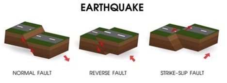
- Description: The most common type of earthquake, tectonic earthquakes, arise from the movement of the Earth’s plates along fault lines. These movements can be due to the plates pulling apart, colliding, sliding past each other, or undergoing compression.
- Example: The Ring of Fire, encircling the Pacific Ocean, is notorious for its frequent and powerful tectonic earthquakes. This area is a hotbed for seismic activity due to the numerous and complex tectonic plate boundaries it encompasses.
Human-Made Earthquake (Induced Seismicity)
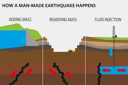
- Collapse Earthquakes: Occur in areas with karst landscapes or near intense mining activities, where the removal of material from the Earth’s crust leads to subsidence and seismic events.
- Explosive Earthquakes: Triggered by the detonation of chemical or nuclear devices, these earthquakes are a direct result of human actions.
- Reservoir-Induced Earthquakes: The construction of large reservoirs can alter the stress on the Earth’s crust, potentially leading to seismic events, such as the Koyna earthquake in 1967 in Maharashtra, India.
Effects and Consequences of Earthquake
- Natural Calamities: Earthquakes can trigger landslides, tsunamis, and mudslides, causing widespread destruction. The 2004 Indian Ocean tsunami, triggered by an undersea earthquake, is one of the deadliest natural disasters in recorded history.
- Loss of Life: Earthquakes and related tsunamis have a profound impact on human lives. The period between 1998 and 2017 saw a significant loss of life due to such events, underscoring the need for effective disaster preparedness and response strategies.
- Surface Rupture and Ground Displacement: The sudden release of energy during an earthquake can cause the ground to break and shift, leading to significant changes in landscapes and damage to infrastructure.
- Changes in Coastline and River Courses: Seismic activity can lead to the submergence or emergence of landforms and alter the courses of rivers, impacting ecosystems and human settlements.
- Structural Damage: Buildings, bridges, roads, and other structures are vulnerable to damage or collapse during earthquakes, posing risks to human safety and causing economic losses.
- Economic Impact: The destruction caused by earthquakes can have a significant economic impact, with costs associated with rebuilding efforts, loss of productivity, and disruption of trade and services.
- Soil Liquefaction: In areas with water-saturated soils, the shaking can cause the ground to behave like a liquid, leading to the failure of foundations and structures.
- Fires: Damaged electrical and gas lines can lead to fires, further exacerbating the disaster’s aftermath.
Earthquake Swarm
An Earthquake Swarm is a seismic phenomenon characterized by a series of many small to moderate earthquakes that occur in a localized area over a period of time, without a single, significantly larger main shock that is typically observed in standard earthquake sequences. The concept of an earthquake swarm diverges from the more common understanding of earthquake activity, where a large main shock is followed by smaller aftershocks.
Characteristics of Earthquake Swarms
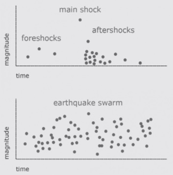
- Localized Activity: Earthquake swarms are confined to a specific, often small geographical region. This localization is one of the defining features, distinguishing swarms from widespread seismic activity.
- Duration: Unlike typical earthquake sequences that might culminate quickly after the main shock and its aftershocks, swarms can persist for extended periods—ranging from days to weeks, and in some cases, even months.
- Magnitude: The earthquakes within a swarm usually have low to moderate magnitudes. The absence of a discernible main shock means there isn’t a significantly larger earthquake that precedes or follows the series of smaller tremors.
- Volume: Swarms can produce thousands of seismic events within a relatively small area. This high frequency of occurrence is a hallmark of the phenomenon.
- Causes: The triggering mechanisms behind earthquake swarms can vary and may include volcanic activity, movements along minor faults, or fluid movements (like water, gas, or magma) within the Earth’s crust.
Example: Palghar District, Maharashtra
The Palghar district in northern Maharashtra, India, serves as a pertinent example of an earthquake swarm. This region has experienced unusual seismic activities characterized as an earthquake swarm, with numerous low to moderate magnitude earthquakes occurring over an extended period without a single dominating main shock.
Implications and Research
- Scientific Interest: Earthquake swarms offer valuable insights into the complex dynamics of the Earth’s crust. Studying them helps scientists understand the various mechanisms that can trigger earthquakes.
- Hazard Assessment: While swarms typically involve low-magnitude earthquakes, their persistent nature and the sheer number of tremors can pose cumulative risks to structures and stress local communities. Understanding and monitoring swarms are crucial for assessing and mitigating these hazards.
- Predictive Challenges: The unpredictable nature of swarms, both in duration and intensity, presents challenges for earthquake prediction and risk management strategies. Unlike traditional earthquake sequences with a main shock followed by diminishing aftershocks, the lack of a clear pattern in swarms complicates forecasting efforts.
Difference between Earthquake and Earthquake Swarm
The differences between a traditional earthquake and an earthquake swarm can be outlined across various parameters, as shown in the table below. This comparison helps to understand the distinct nature of earthquake swarms compared to the conventional understanding of earthquakes.
| Parameter | Earthquake | Earthquake Swarm |
| Main Shock | A definite main shock is present. | Lacks a definite main shock. |
| After Shock | Generally followed by aftershocks. | No aftershocks are observed. |
| Occurrence Duration | Main shock is followed by aftershocks, which decrease over time. | Typically short-lived, but can extend for days, weeks, or months. |
| Causes | Caused by seismic waves generated in lithospheric plates due to the sudden release of energy. | In addition to seismic activity, hydro-seismicity due to water percolation is also a contributing factor. |
| Frequency of Occurrence | Regular occurrence. | Rarely occurs. |
| Recurrence | Occurs at varied time intervals. | Tends to reoccur more frequently within the swarm period. |
| Magnitude | Exhibits a large variation, ranging from high to low. | Generally characterized by low magnitudes. |
| Intensity | Can range from low to high intensity. | Typically demonstrates low intensity. |
| Destruction Caused | Can cause very high levels of destruction, sometimes disastrous. | Results in comparatively less destruction. |
Seismic Mapping and Earthquake Zones in India: An In-Depth Analysis
India’s geographical positioning makes it susceptible to seismic activities, leading to a significant portion of the country being vulnerable to earthquakes. This vulnerability is a consequence of its placement on the tectonic plates and the dynamic nature of the Earth’s crust in these regions. An elaborate understanding of seismic mapping and earthquake zones in India reveals the country’s efforts to mitigate and prepare for seismic hazards.
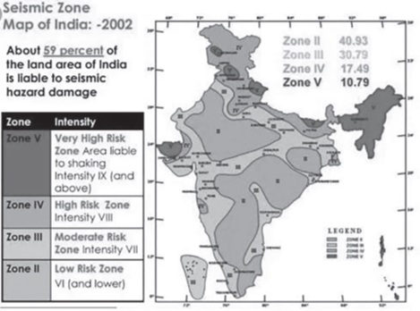
Vulnerability to Earthquakes
- Extent of Vulnerability: The National Disaster Management Authority (NDMA) highlights that about 59% of India’s land area is vulnerable to seismic activities, with 57% of this area categorized under high seismic zones. This data underscores the widespread nature of earthquake risks across the country.
- Historical Impact: Over the past 15 years, India has witnessed 10 major earthquakes, leading to more than 20,000 fatalities. These tragic events underscore the critical need for effective earthquake preparedness and response strategies.
Seismic Zones in India
The seismic zoning map of India, devised by the Bureau of Indian Standards (BIS) in collaboration with the Indian Meteorological Department (IMD), divides the country into four primary seismic zones based on the modified Mercalli intensity scale.
This classification aids in understanding the varying degrees of seismic risk across different regions:
- Seismic Zone II: This zone is characterized by areas prone to minor earthquake damage, corresponding to intensities V to VI on the Modified Mercalli Intensity (MMI) scale. These areas experience less frequent and less severe seismic activity compared to other zones.
- Seismic Zone III: Regions in this zone are at risk of moderate damage from earthquakes, with seismic intensity equivalent to VII on the MMI scale. This indicates a higher likelihood of damaging earthquakes than Zone II.
- Seismic Zone IV: This zone includes areas susceptible to major damage, with intensities at VII or higher on the MMI scale. The regions in this zone require stringent building codes and preparedness measures to mitigate earthquake risks.
- Seismic Zone V: Identified as the most seismically active region, it encompasses areas near major fault lines. This zone includes the entire northeastern India, parts of Jammu and Kashmir, Himachal Pradesh, Uttarakhand, the Rann of Kutch in Gujarat, parts of North Bihar, and the Andaman & Nicobar Islands. Zone V is prone to the most severe earthquakes, often greater than magnitude 8.0.
Causes of Earthquakes in India
- The primary cause of seismic activity in India is the tectonic movement of the Indian plate towards the Eurasian plate at a rate of about 50 mm/year. This movement is especially significant along the Himalayan belt, which is susceptible to great earthquakes of magnitude more than 8.0. Besides the Himalayan region, the Indo-Gangetic plains and peninsular India have also experienced damaging earthquakes, as evidenced by the events in Koyna (1967), Latur (1993), and Jabalpur (1997).
- Understanding the seismic mapping and earthquake zones in India is crucial for effective disaster management and mitigation strategies. The classification of the country into different seismic zones serves as a foundation for establishing building codes, preparedness measures, and response strategies tailored to the specific risks faced by each region. Enhanced awareness and preparedness are vital in reducing the impact of earthquakes on lives and infrastructure, highlighting the importance of continued research and investment in seismic risk management.
- The Himalayan region is known for its majestic mountains and breathtaking landscapes, but it is also a hotspot for frequent seismic activity. This phenomenon can be attributed to several geological and tectonic factors that contribute to the instability and vulnerability of the region.
Geological Characteristics and Location
- Young Fold Mountains: The Himalayas are classified as young fold mountains, which means they have been formed relatively recently in geological terms. This formation is a result of the folding of the earth’s crust caused by tectonic movements.
- Continental Collision Zone: The primary reason behind the seismic activity in the Himalayan region is its location at the collision boundary between the Indian Plate and the Eurasian Plate. This collision zone is characterized by ongoing tectonic processes, including the subduction of the Indian Plate beneath the Eurasian Plate.
Tectonic Activity
- Plate Movement: The Indian Plate is continuously moving northward at a rate of approximately 50 mm/year towards the Eurasian Plate. This relentless motion leads to significant stress accumulation along the collision boundary, making the area prone to earthquakes.
- Mountain Building Processes: The collision of these two plates not only formed the Himalayas but also results in their continuous rise. This ongoing orogeny (mountain-building process) contributes to the tectonic activity in the region, as the crust is constantly being deformed.
Isostatic Imbalance
- Lack of Isostatic Equilibrium: Isostatic equilibrium is a state of gravitational balance or stability within the Earth’s crust. The Himalayas have not yet reached this state of equilibrium, which means that the crust in this region is still adjusting. This lack of balance contributes to the geological instability, making the area more susceptible to seismic disturbances.
Implications of Seismic Activity
- Vulnerability to Earthquakes: The combination of these factors makes the Himalayan region highly vulnerable to earthquakes. These seismic events can range from minor tremors to major earthquakes, posing significant risks to the populations living in this area.
- Continuous Monitoring: Due to the high risk of seismic activity, it is crucial for there to be continuous monitoring of the Himalayan region. This includes seismic surveys, GPS measurements, and other geological studies to better understand the tectonic processes at play and to potentially predict major seismic events.
- The frequent seismic activity in the Himalayan region is a direct consequence of its geological and tectonic characteristics. The ongoing collision between the Indian and Eurasian Plates, the process of mountain building, and the lack of isostatic equilibrium contribute to the region’s instability. Understanding these underlying causes is crucial for disaster preparedness and mitigation efforts in the Himalayas and surrounding areas.
Reasons for The Earthquake Proneness in India
The earthquake proneness of India is a multifaceted issue that can be attributed to a combination of geological, geographical, and human factors. Understanding these factors requires an in-depth exploration of the reasons that make India vulnerable to earthquakes. This exploration includes plate tectonics, geographical features, and the impact of human activities.
Plate Movement
- India Plate and Eurasia Collision: The Indian Plate is moving northward at a rate of approximately 50 millimeters per year and colliding with the Eurasian Plate. This collision is a significant source of seismic activity in the region. The process of plate tectonics, specifically the convergent boundary between the India and Eurasia plates, leads to the building up of strain in the Earth’s crust. When this strain is released, it results in earthquakes.
- Burma Plate Interaction: The collision and interaction between the Burma Plate and the Java-Sumatra Plate also contribute to the seismic tension in the region. This tectonic activity causes strain in the underlying plates, making the surrounding areas, including parts of India, susceptible to earthquakes.
Geography
- Seafloor Displacement in Andaman and Nicobar Islands: The geographical positioning of the Andaman and Nicobar Islands makes them prone to seafloor displacement and activities related to oceanic underwater volcanoes. These geological processes can lead to disturbances on the Earth’s surface, manifesting as earthquakes. The islands are located in a seismically active zone, which is influenced by the tectonic movements of the Indian Plate and the Eurasian Plate.
- Fault Line in the Deccan Plateau: The emergence of fault lines in the Deccan Plateau is another geological feature contributing to India’s earthquake vulnerability. The build-up of energy along these fault lines, such as the one along the river Bhima (Krishna) near Latur and Osmanabad in Maharashtra, poses a significant risk. When the energy accumulated along these fault lines is released, it can lead to devastating earthquakes.
Human Factors
- Unscientific Urbanization: The rapid increase in population and the corresponding unscientific urbanization and construction practices exacerbate the vulnerability to earthquakes. In many areas, buildings and infrastructure are not designed or built to withstand seismic forces. This lack of preparedness and resilience in urban planning and construction practices increases the potential damage and casualties during an earthquake.
- The earthquake proneness of India is a complex interplay of natural and human factors. The tectonic movements and geological features, such as the collision of the Indian Plate with the Eurasian Plate, the seafloor displacement in the Andaman and Nicobar Islands, and the presence of fault lines in the Deccan Plateau, lay the natural groundwork for seismic activity. Simultaneously, human factors like rapid and unscientific urbanization further amplify the risks. Addressing these vulnerabilities requires a comprehensive approach, including enhanced earthquake preparedness, resilient urban planning, and public awareness campaigns to mitigate the impact of earthquakes in India.
Global Distribution of Earthquakes
The global distribution of earthquakes is primarily concentrated along specific seismic belts, with the circum-Pacific seismic belt and the Alpine-Himalayan belt being the most significant. These belts are directly related to the boundaries between tectonic plates, where the movement of these plates against, away from, or under each other leads to seismic activity.
Circum-Pacific Seismic Belt (Ring of Fire)
- Location and Extent: The circum-Pacific seismic belt, commonly known as the “Ring of Fire,” encircles the Pacific Ocean, touching the coastal areas of North and South America, the Aleutian Islands, Japan, the Philippines, Indonesia, and New Zealand.
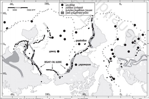
- Characteristics: This belt is the most earthquake-prone zone in the world, accounting for about 81% of the largest earthquakes recorded. The “Ring of Fire” is characterized by intense seismic and volcanic activity.
- Cause of Seismic Activity: The primary cause of the earthquakes in this belt is the subduction of the Pacific Plate and other smaller plates like the Philippine Sea Plate beneath continental and other oceanic plates. This process occurs at convergent plate boundaries, where the denser oceanic plate is forced under the lighter continental plate or another oceanic plate, leading to powerful earthquakes and volcanic eruptions.
Significant Earthquakes:
- The 2010 Chile earthquake, which was one of the most powerful earthquakes ever recorded, occurred along the boundary between the Nazca and South American plates.
- The 2011 Japan earthquake, which triggered a devastating tsunami, occurred in the subduction zone where the Pacific Plate is subducting beneath the North American Plate.
- The 2004 Indian Ocean tsunami, caused by an undersea earthquake off the coast of Sumatra, Indonesia, is another tragic example of the seismic activity associated with subduction zones, although it is technically outside the “Ring of Fire.”
Alpine-Himalayan Seismic Belt
- Location and Extent: This seismic belt extends from the Mediterranean region, through the Himalayas, to the Indonesian archipelago, encompassing regions with complex tectonic settings.
- Characteristics: About 17% of the world’s largest earthquakes occur in this belt. It is marked by a series of collision zones where continental plates converge, leading to the uplift of mountain ranges such as the Alps and the Himalayas.
- Cause of Seismic Activity: The seismic activity in this belt is primarily due to the collision between the Eurasian Plate and the African, Arabian, and Indian plates. This continental-continental plate convergence results in significant crustal deformation, leading to frequent and sometimes very powerful earthquakes.
Significant Earthquakes:
- The 2005 Kashmir earthquake, occurring in the Pakistan-India border region of the Himalayas, is an example of the seismic potential of this belt.
- The 1950 Assam-Tibet earthquake, one of the largest earthquakes of the 20th century, also occurred within this seismic belt.
Mid-Atlantic Ridge
- Location and Extent: This underwater mountain range extends down the middle of the Atlantic Ocean, from the Arctic Ocean to the Southern Ocean.
- Characteristics: The ridge marks a divergent plate boundary, where the North American and Eurasian plates in the North Atlantic, and the South American and African plates in the South Atlantic, are moving away from each other.
- Cause of Seismic Activity: The seismic activity along the Mid-Atlantic Ridge is due to the process of seafloor spreading, where magma rises from beneath the Earth’s crust to fill the gap created by the diverging plates. This process is generally less violent than subduction but can still cause significant earthquakes.
- Significant Earthquakes: While the Mid-Atlantic Ridge is less known for large earthquakes compared to the circum-Pacific belt and the Alpine-Himalayan belt, it still experiences frequent seismic activity that contributes to the gradual widening of the Atlantic Ocean.
Understanding Seismic Waves
Seismic waves are energy waves generated by the sudden breaking of rock within the earth or an explosion. They are the primary tool through which geologists understand the Earth’s interior. Seismic waves are categorized into three main types:
- Primary (P) Waves: These are compressional waves that are fast-moving and can travel through solids, liquids, and gases.
- Secondary (S) Waves: Slower than P waves, S waves are shear waves that can only move through solids, causing the ground to shake in their passage.
- Surface Waves: These waves travel along the Earth’s surface and are generally responsible for the damage and ground shaking felt during earthquakes.
The Mayotte Seismic Event
The seismic event near Mayotte was remarkable for several reasons:
- Location: Mayotte is a French department located in the Comoros archipelago between Africa’s southeastern coast and Madagascar. The region is known for its volcanic activity, but the seismic waves detected in November 2018 did not align with typical patterns associated with volcanic activity or earthquakes.
- Characteristics of the Waves: Unlike the typical seismic waves generated by earthquakes, the waves from this event were described as low-frequency monochromatic waves. Monochromatic waves have a single frequency, indicating a very uniform motion over an extended period—more than 20 minutes in this case. This uniformity and duration are unusual for seismic activity, which typically exhibits a broader range of frequencies and a shorter duration.
- Detection and Analysis: The waves were detected by seismologists worldwide, yet their origin puzzled researchers. Initial analysis suggested that these waves might be related to a unique type of geological activity, possibly linked to the volcanic system near Mayotte, which had been experiencing a series of earthquakes since May 2018.
Hypotheses and Implications
Several hypotheses have been proposed to explain the origin of these mysterious waves:
- Volcanic Activity: One leading theory suggests that the waves were related to a massive movement of magma beneath the Earth’s crust, possibly a slow, underground volcanic eruption. This theory is supported by the fact that Mayotte has been slowly sinking and moving eastward, likely due to the emptying of a magma chamber beneath the island.
- Underwater Landslide: Another possibility is an underwater landslide or a significant shift in the ocean floor’s geological structures, which could generate low-frequency waves over a prolonged period.
Ongoing Research and Impact
The Mayotte seismic event underscores the importance of continuous monitoring and research in geology and seismology. It highlights the dynamic and often unpredictable nature of the Earth’s geological processes. Further investigation into this event could provide valuable insights into underwater volcanic activity, the behavior of deep Earth structures, and the generation of seismic waves.
Understanding such phenomena is crucial for improving our ability to predict and mitigate the impacts of natural disasters, contributing to the safety and preparedness of communities around the globe. The Mayotte event remains an area of active research, with scientists utilizing satellite data, ocean floor mapping, and seismic analysis to unravel the mystery behind these unusual waves.
Earthquake Hazard Management and Mitigation Strategies
Earthquake hazard management and mitigation encompass a comprehensive approach aimed at minimizing the impacts of earthquakes. Given the inevitability of such natural disasters, the focus shifts towards preparation, risk reduction, and recovery strategies to safeguard lives and infrastructure.
- Risk Recognition
- Identification of Vulnerable Hotspots: The initial step in earthquake management involves identifying areas most susceptible to seismic activities. This process includes analyzing geological data, historical earthquake patterns, and the region’s seismicity to pinpoint locations at heightened risk.
- Establishment of Monitoring Centers
- Seismological Centers: The creation of earthquake monitoring or seismological centers is critical for the regular observation of seismic activities. These centers play a vital role in the early detection of earthquakes and the rapid dissemination of information to the public and relevant authorities.
- Early Warning System
- Forecasting and Alerts: An effective early warning system is essential for providing timely alerts before the seismic waves reach populated areas. Inspired by systems in countries like Japan, these systems use electronic signals to forecast earthquakes, allowing for earlier warnings that can save lives and reduce damage.
- Vulnerability Mapping
- Pre-Preparedness Strategies: Vulnerability mapping involves assessing and documenting the specific risks faced by different regions. This stage is crucial for understanding the extent of potential impacts and for educating the public about these risks, thereby enhancing community preparedness.
- Earthquake Resilient Structures
- Infrastructure Development: Building earthquake-resistant structures is paramount in areas prone to seismic activity. This involves adopting engineering practices and materials that can withstand earthquake forces, thereby protecting buildings and their occupants. Ongoing research into cost-effective, quake-resistant construction methods is essential for broader implementation.
- Construction Regulations
- Building Codes and Zoning Laws: Implementing stringent construction regulations is necessary to ensure that new buildings and infrastructure are designed to resist earthquakes. This includes discouraging the construction of high-rise buildings and large industrial establishments in areas identified as highly vulnerable to seismic activity.
- Effective earthquake hazard management and mitigation require a multi-faceted approach that combines scientific, engineering, and community-based strategies. By recognizing risks, establishing monitoring and early warning systems, conducting vulnerability mapping, enforcing construction regulations, and promoting the development of resilient structures, societies can significantly reduce the devastating impacts of earthquakes. Collaboration among governments, research institutions, and communities is crucial in advancing these efforts, ensuring that both pre-hazard risk reduction and post-disaster recovery strategies are in place to protect lives and assets.
Tsunamis
Tsunamis are among the most powerful and destructive natural phenomena on Earth. The term “tsunami” itself originates from the Japanese language, composed of two characters: “Tsu” (harbor) and “Nami” (wave). Together, these characters describe a significant sea wave phenomenon generated by seismic activities beneath the ocean’s surface.
Causes of Tsunamis
Tsunamis can be triggered by various geophysical events, all of which involve substantial movement of the Earth’s surface beneath the ocean. These events include:
- Earthquakes: The primary cause of tsunamis. When tectonic plates shift abruptly during an underwater earthquake, the ocean floor displaces water above, creating waves that can travel vast distances. Notable examples include the 1960 Great Chilean Tsunami, triggered by a magnitude 9.5 earthquake, and the 2004 Indian Ocean Tsunami, caused by the Sumatra-Andaman earthquake.
- Landslides: Underwater landslides, often triggered by earthquakes, can also generate tsunamis. A notable case is the 1998 Papua New Guinea tsunami, where a landslide led to massive waves.
- Volcanic Eruptions: Submarine volcanic eruptions and the subsequent collapse of volcanic structures can displace water and generate tsunamis. The 1883 Krakatoa volcanic eruption in Indonesia is a prime example, causing a deadly tsunami.
Characteristics of Tsunami Waves
Tsunami waves have distinct properties that set them apart from ordinary sea waves:
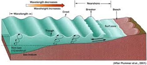
- High Wavelength and Low Amplitude: In the deep ocean, tsunami waves have long wavelengths and relatively low amplitudes, making them difficult to detect and resembling normal sea waves.
- High Kinetic Energy and Velocity: Despite their low surface amplitude, tsunami waves carry vast amounts of energy, enabling them to travel across entire ocean basins at high speeds.
- Surface Water Movement: Unlike wind-generated waves, the water at the ocean’s surface does not move significantly with a tsunami. Instead, the energy of the wave travels through the water.
Detection and Impact Near Coastlines
Detecting tsunamis in the deep ocean is challenging due to their long wavelengths and low amplitudes. However, as they approach shallower coastal waters, their behavior changes dramatically:
- Increase in Amplitude: The decrease in water depth causes the tsunami’s wavelength to shorten and its amplitude to increase, making the waves more pronounced and powerful.
- Energy Transformation: As the wave’s amplitude increases, its potential energy also increases while kinetic energy decreases, resulting in slower but more forceful waves.
Warning Signs and Destructive Potential
- A receding coastline, where water withdraws significantly from the shore, often precedes the arrival of a tsunami. This natural warning sign can indicate the imminent arrival of the tsunami’s most destructive waves. Unfortunately, the phenomenon can catch coastal populations off-guard, especially if the first wave is not immediately recognized as a precursor to more destructive waves that follow.
Understanding the dynamics, causes, and warning signs of tsunamis is crucial for preparedness and mitigation efforts. Through continued research and the development of early warning systems, communities around the world aim to reduce the devastating impact of these natural disasters.
Tsunami
Tsunamis, a series of ocean waves with extremely long wavelengths caused by large-scale disturbances of the ocean, such as earthquakes, volcanic eruptions, glacier calvings, or meteorite impacts, have been a significant natural hazard for coastal regions worldwide. India, with its vast coastline, is no exception to the threats posed by tsunamis, particularly along its eastern coast due to its proximity to the seismic activities in the Indian Ocean region.
Seismic Activity and Tsunami Risk
Since the catastrophic tsunami of 2004, India has not experienced another tsunami. However, the region remains vigilant due to ongoing seismic activities, particularly in the Northern Bay of Bengal, which have been accompanied by high waves. These activities underscore the need for continuous monitoring and preparedness along the Indian coast.
Tsunami-Prone Areas Along the Eastern Coast
The Indian government, recognizing the significant threat tsunamis pose to its coastal communities, has undertaken extensive mapping of the tsunami-prone areas along the eastern coast. This mapping initiative has identified several critical zones, including:
- Puri
- Kakinada
- Machilipatnam
- Nizampatnam-Vetapalem
- Chennai
- Cuddalore-Pondicherry
- Rameshwaram
- Thoothukudi
- Alappuzha-Chavara
- Kochi
These areas are considered high-risk due to their geographical location, proximity to seismic fault lines, and historical tsunami impacts. The mapping serves as a crucial tool for disaster management and mitigation efforts, aiming to reduce the potential impact of future tsunamis.
Historical Tsunamis Affecting India
The 1941 Andaman Island Earthquake and Tsunami
On June 26, 1941, an earthquake with a magnitude ranging from 7.1 to 8.8 struck the Andaman Islands, triggering a tsunami that affected Southeast Asia, including Bangladesh, Myanmar, and Thailand. This event caused significant casualties and damage, highlighting the widespread devastation that tsunamis can inflict.
The 2004 Indian Ocean Tsunami
The most devastating tsunami in recent memory for India was the 2004 Indian Ocean tsunami, also known as the Boxing Day Tsunami or the Sumatra-Andaman earthquake. This disaster followed an undersea megathrust earthquake off the coast of Sumatra, Indonesia.
- Impact on India: The tsunami had a disastrous impact on several Indian states and territories, including Tamil Nadu, Andhra Pradesh, Kerala, and the Andaman and Nicobar Islands, particularly Little Andaman. It led to the destruction of over 235,000 dwelling units across the Indian region, showcasing the massive scale of displacement and loss.
- Indira Point Submergence: Indira Point, the southernmost tip of Indian territory, was submerged after the tsunami, marking a significant geographical and ecological impact.
The Tsunami Early Warning System (TEWS)
The Tsunami Early Warning System (TEWS) in India represents a critical infrastructure aimed at mitigating the impacts of tsunamis, which, like earthquakes, cannot be predicted with absolute certainty. The devastating tsunami of 2004 underscored the vital need for such systems, leading to the establishment and integration of India into international tsunami warning networks. The structure and operational strategies of TEWS in India are designed to maximize preparedness, ensure rapid response, and facilitate efficient post-tsunami recovery efforts.
Components of the Tsunami Early Warning System
1. Sensor Network:
- Real-time Seismic Monitoring: At the heart of the TEWS lies a sophisticated network of 17 broadband seismic stations. These stations are strategically located to detect tsunamigenic earthquakes—earthquakes that have the potential to generate tsunamis. The early detection of such seismic activities is crucial for the timely activation of warning protocols.
- DART System (Deep Ocean Assessment and Reporting of Tsunamis): This advanced technology plays a pivotal role in the TEWS. DART consists of a network of buoys and sensors deployed in the deep ocean. These instruments measure changes in water pressure that indicate the passage of a tsunami wave. Recognized globally for its efficacy, the DART system enhances the ability to assess tsunami threats in real time.
2. Communication Network:
- The effectiveness of an early warning system heavily relies on its ability to disseminate warnings promptly to those at risk. India’s TEWS encompasses a comprehensive communication infrastructure that ensures rapid transmission of alerts and necessary information to the vulnerable coastal communities. This network enables authorities to instruct and assist people in evacuating dangerous areas well in advance of a tsunami’s arrival.
Operational Strategies
- International Collaboration:
- Post the 2004 tsunami, India became an active participant in the International Tsunami Warning System. This global framework facilitates the exchange of critical data and information, enhancing the accuracy and reach of tsunami warnings.
- Indian Tsunami Early Warning Center (ITEWC):
- Located within the Indian National Center for Ocean Information Services (INCOIS) in Hyderabad, the ITEWC is the operational core of India’s TEWS. It not only monitors seismic activities but also evaluates potential tsunami threats and issues warnings accordingly.
- As a testament to its capabilities, the ITEWC extends its services beyond India, offering support to 25 countries in the Indian Ocean region. This role underscores India’s commitment to regional and international efforts in tsunami risk reduction.
- Regional Tsunami Advisory Service:
- In collaboration with Australia and Indonesia, India serves as one of the Regional Tsunami Advisory Service Providers for the Indian Ocean. This tripartite arrangement enhances the collective ability to monitor, assess, and warn against tsunamis across the region.
Significance and Impact
The establishment and ongoing refinement of the Tsunami Early Warning System in India represent critical steps toward safeguarding lives and properties against the devastating effects of tsunamis. By leveraging advanced technologies like the DART system and fostering international cooperation, India has significantly enhanced its preparedness and response capabilities. The ITEWC’s role in providing timely and accurate warnings not only to Indian coastal communities but also to a broader regional audience illustrates a proactive approach to disaster risk management and a commitment to humanitarian assistance on a global scale.
INCOIS
The Indian National Centre for Ocean Information Services (INCOIS), established in 1999 and based in Hyderabad, is an autonomous organization under the Ministry of Earth Sciences, Government of India. Its formation underscores India’s commitment to advancing oceanography and related fields, especially in the context of disaster management and mitigation. This in-depth explanation will cover its responsibilities, technological infrastructure, and contributions to hazard mapping and mitigation measures, particularly concerning tsunamis.
Responsibilities and Core Functions
INCOIS is tasked with several critical functions aimed at enhancing the safety and well-being of the coastal and marine communities. Its primary responsibilities include:
- Tsunami Early Warnings: Perhaps the most critical role of INCOIS is the provision of timely and accurate tsunami warnings. This capability is crucial for minimizing the impact of tsunamis on India’s extensive coastline. The center employs advanced computational models and real-time data from ocean buoys and seismic networks to predict tsunami occurrences and disseminate warnings.
- Dissemination of Ocean Information: Beyond tsunamis, INCOIS provides a wide array of ocean information services, including potential fishing zone advisories, ocean state forecasts, and alerts on storm surges and high waves. These services are vital for the livelihoods of fishermen, the safety of maritime operations, and the planning and execution of coastal activities.
Technological Infrastructure
INCOIS leverages advanced technological tools to fulfill its mission, including:
- Global Navigation Satellite System (GNSS): Deployed in the strategically important Andaman and Nicobar Islands, the GNSS aids in the precise measurement of tectonic plate movements. These measurements are essential for the early detection of seismic events that could trigger tsunamis.
- Strong Motion Accelerometers: These devices, also installed in the Andaman and Nicobar Islands, are designed to measure the intense ground movements occurring during an earthquake. By providing immediate data on seismic activities, they enable quicker assessment and response to potential tsunami threats.
Multi-hazard Vulnerable Mapping
Understanding the risks associated with not only tsunamis but also other natural disasters is vital for comprehensive coastal management. INCOIS undertakes multi-hazard vulnerability mapping of the Indian coastland, which involves:
- Risk Assessment: Identifying areas most at risk from various natural hazards, including tsunamis, cyclones, and storm surges.
- Hazard Mapping: Developing detailed maps that highlight the areas most susceptible to specific hazards. These maps are crucial for disaster preparedness and mitigation planning.
- Mitigation Measures: Based on the risk and hazard assessments, INCOIS recommends specific mitigation measures. These can include structural solutions like seawalls and tsunami shelters, as well as non-structural measures like early warning systems, community education, and evacuation planning.
Tsunami Risk, Hazard, and Mitigation Measures
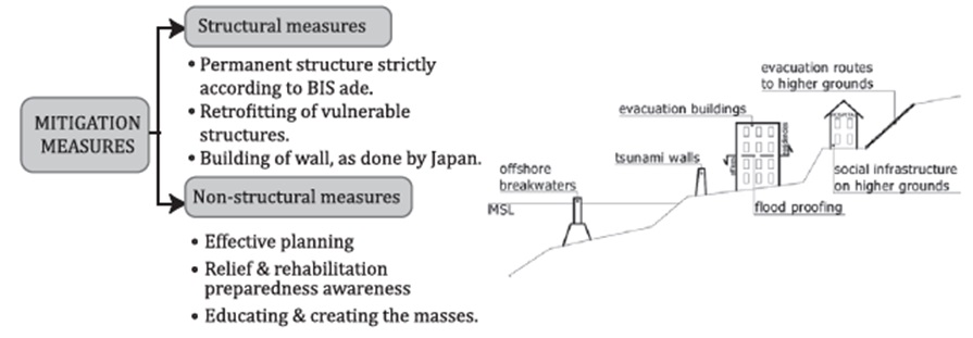
Tsunami risk assessment and mitigation are central to INCOIS’s mission. The center’s efforts in this area include:
- Early Warning System: The cornerstone of tsunami mitigation, this system is designed to provide as much advance notice as possible of approaching tsunamis, allowing for timely evacuations and other protective actions.
- Public Awareness and Education: INCOIS conducts programs aimed at increasing awareness about tsunamis among the coastal population. Understanding the warning signs and knowing how to respond can significantly reduce the risk to life and property.
- International Collaboration: Tsunami mitigation is a global concern, and INCOIS collaborates with international centers and participates in global networks to enhance its warning systems and share best practices.
Volcanoes
Definition and Basic Understanding
- Volcano: A volcano is essentially a fissure or opening in the Earth’s crust through which molten rock, gases, and ash are expelled. This geological feature serves as a natural outlet for the Earth’s internal heat and pressure.
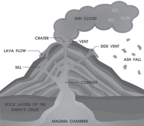
Volcanism: The Underlying Process
- Volcanism: This term refers to the process of magma (molten rock beneath the Earth’s surface) moving from a magma chamber within the Earth’s upper mantle or lower crust to the surface. Volcanism is responsible for forming not only the volcanic mountains and islands but also various geological formations through the cooling and solidification of lava.
Eruptive Materials and Gases
- Eruptive Outputs: During a volcanic eruption, a variety of materials can be expelled, including:
- Lava Flows: Streams of molten rock that cool and solidify on the Earth’s surface.
- Pyroclastic Debris: A mixture of volcanic ash, lapilli (small stones), and volcanic bombs (larger ejected rocks), which can form pyroclastic flows.
- Volcanic Bombs: Large blobs of magma that cool into solid fragments before hitting the ground.
- Ash and Dust: Fine particles of volcanic rock and glass that can be carried far by the wind.
- Gases: Volcanoes release several gases, including:
- Water Vapor (H2O): The most abundant volcanic gas.
- Carbon Dioxide (CO2) and Sulfur Dioxide (SO2): These gases can contribute to climate change and acid rain, respectively.
- Nitrogen Compounds, Chlorine, Hydrogen, and Argon: These are present in smaller quantities but play roles in various geological and atmospheric processes.
Notable Volcanoes on Earth and Mars
- Olympus Mons: The Martian Giant
- Olympus Mons on Mars: Recognized as the tallest volcano in our solar system, Olympus Mons is a shield volcano with a height of about 22 km (13.6 miles). Its massive size is attributed to the low gravity of Mars and the lack of tectonic plate movement, allowing the volcano to grow over millions of years without significant erosion.
- Mauna Kea: The Earthly Behemoth
- Mauna Kea in Hawaii: On Earth, Mauna Kea represents the tallest volcano when measured from its base on the ocean floor to its summit. This measurement gives it a total height of approximately 10,211 meters (33,500 feet), surpassing Mount Everest’s height above sea level. Mauna Kea is a shield volcano, noted for its gentle slopes formed by low-viscosity lava flows.
- Volcanoes: Windows to Earth’s Interior
- Volcanoes are not just natural hazards; they are also key to understanding the Earth’s interior. Through the study of volcanic materials, scientists can gain insights into the composition and dynamics of the Earth’s mantle. Furthermore, volcanic soils are often highly fertile, supporting rich agricultural landscapes, and geothermal energy harnessed from volcanic areas can provide sustainable energy sources.
Eruptions, whether on Earth or other planets, are a fascinating and complex process that play a critical role in the geological dynamics of a planet. The process of eruption is primarily associated with volcanoes on Earth, but it can also apply to other phenomena on different celestial bodies, such as ice volcanoes on some of the moons in our Solar System or cryovolcanoes on Pluto
- Eruptions
- An eruption is a natural geological process through which a planet expels substances from its interior to its surface. This can include lava, gases, ash, and rock fragments. Eruptions are a key way planets regulate internal temperature and pressure, contributing to the formation and alteration of their landscapes.
- Causes of Eruptions
- The primary cause of volcanic eruptions is the pressure from gases and molten rock, or magma, beneath a planet’s surface. This pressure builds up over time due to the heat from the planet’s internal radioactive decay and, in some cases, tidal heating (in the context of moons and other celestial bodies). When the pressure exceeds the strength of the rock above it, an eruption occurs.
- Magma Formation
- Heat Source: The heat necessary for magma formation comes from the decay of radioactive elements within the planet’s mantle and core.
- Melting: This heat melts rock in the mantle, forming magma. The exact composition of the magma can vary based on the types of rock that melt and any other substances present, such as water, which can lower the melting point of rock.
- Pressure Buildup
- Gas Expansion: As magma rises toward the surface, the pressure decreases, causing gases dissolved in the magma to expand.
- Fracturing: The expanding gases increase the pressure on the surrounding rock, leading to fracturing and, eventually, the formation of a pathway to the surface.
- Types of Eruptions
- Eruptions can vary widely in their intensity, duration, and the materials they emit. The nature of an eruption largely depends on the viscosity of the magma and the amount and types of gases it contains.
- Effusive Eruptions
- Characteristics: Low-viscosity magma leads to gentle flows of lava.
- Example: The eruptions of shield volcanoes, like those in Hawaii.
- Explosive Eruptions
- Characteristics: High-viscosity magma traps gases, leading to powerful explosions.
- Example: The 1980 eruption of Mount St. Helens.
- Impact of Eruptions
- Eruptions can have profound impacts on the planet’s surface and atmosphere, as well as the biosphere.
- Landscape Formation: Lava flows and ash deposits can create new landforms, such as islands, mountains, and plateaus.
- Atmospheric Effects: Gases and ash released during eruptions can alter the planet’s atmosphere, impacting climate and air quality.
- Habitat Creation and Destruction: While eruptions can destroy existing ecosystems, they also create new habitats for colonization.
Parts of a Volcano
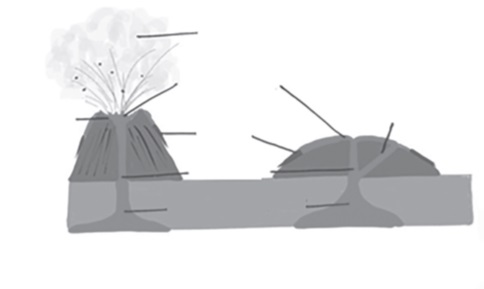
- Magma Chamber
- Definition: A large, underground pool of molten rock found beneath the surface of the Earth.
- Function: Acts as a reservoir for magma, where it is stored before an eruption. The magma in this chamber is a mixture of molten or semi-molten rock, volatiles, and solids such as crystals and rock fragments.
- Conduit
- Definition: A tubular passage that magma uses to travel from the magma chamber to the Earth’s surface.
- Function: Functions as the pathway through which magma moves. When the pressure in the magma chamber is high enough, magma is forced upward through the conduit towards the vent.
- Vent
- Definition: The surface opening of a volcano.
- Function: Serves as the exit point for volcanic materials during an eruption. This includes the ejection of lava flows, volcanic ash, gases, and pyroclastic materials. While many volcanoes have multiple secondary vents, there is typically one primary vent that is the main outlet for eruption.
- Crater
- Definition: A bowl-shaped depression atop a volcano surrounding the vent.
- Function: Formed by the explosive ejection of rock and other materials during an eruption, craters are often the focal point for subsequent eruptions. They can accumulate rainwater, forming crater lakes in some instances.
- Slopes or Flanks
- Definition: The sides of a volcano.
- Function: Composed of accumulated volcanic material from past eruptions, the slopes are shaped by the nature of the volcanic activity, including lava flows, ash deposition, and landslides.
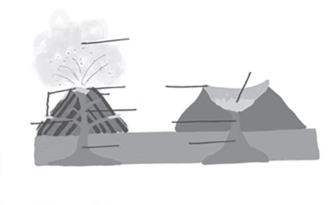
Factors Responsible for Volcanic Activity
- Plate Tectonics
- Mechanism: The Earth’s lithosphere is divided into tectonic plates that float atop the semi-fluid asthenosphere. Volcanic activity is often concentrated at plate boundaries due to interactions such as convergence (where plates move towards each other) and subduction (where one plate is forced below another).
- Result: These processes can lead to the melting of mantle materials, forming magma that rises to the surface, resulting in volcanic eruptions.
- Ocean Floor Spreading
- Mechanism: At mid-ocean ridges, tectonic plates diverge, or move apart, allowing magma to rise from below the Earth’s surface.
- Result: The upwelling of magma leads to the formation of new oceanic crust and can create volcanic islands along the ridge.
- Weak Earth Surface
- Mechanism: Volcanic activity can also occur in areas where the Earth’s crust is thin or weakened, allowing magma to reach the surface more easily.
- Result: This can lead to eruptions in locations that are not directly associated with plate boundaries.
- Hot Spots
- Mechanism: Hot spots are areas of intense heat in the mantle that can melt rock, forming magma. As a tectonic plate moves over a hot spot, the heat can create a series of volcanoes.
- Result: Unlike most volcanism, which occurs at plate boundaries, hot spot volcanism can take place in the middle of tectonic plates, leading to volcanic island chains like the Hawaiian Islands.
- Decrease in External Pressure
- Mechanism: A decrease in the pressure exerted on the magma chamber, for instance, due to the removal of overlying rock or rapid glacial melting, can trigger an eruption.
- Result: The reduction in pressure decreases the solubility of gases in the magma, causing them to expand and forcing the magma to erupt at the surface.
Classification of Volcano
Based on the Frequency of Eruption
- Active Volcano: These are volcanoes that erupt frequently. Examples include:
- Stromboli and Mt. Etna in Italy, which are among the most active volcanoes in the world and are known for their frequent explosive eruptions.
- Kilauea in Hawaii, which is a shield volcano known for its continuous lava flow.
- Mount St. Helens in the USA, famous for its catastrophic eruption in 1980.
- Dormant Volcano: These volcanoes are not extinct but haven’t erupted in recent history, indicating a pause in activity rather than the end of it. Examples are:
- Mount Kilimanjaro in Tanzania, Africa, which hasn’t erupted in tens of thousands of years but is not considered extinct.
- Mount Fuji in Japan, which last erupted in the early 1700s and is an iconic symbol of Japan.
- Extinct Volcano: These have erupted in the distant geological past and show no signs of future volcanic activity. Examples include:
- Mount Balikabok in the Philippines, which has no recorded history of eruptions.
- Mount Thielsen in Oregon in the USA, which is considered a shield volcano and has been eroded over time, showing no recent activity.
Based on the Nature of Lava
- Andesitic Eruption: Characterized by the explosive eruption of andesitic lava, which is high in silica and creates viscous and acidic lava. This type of lava cools and solidifies quickly, forming large and steep volcanic structures. The high silica content makes the lava thick, leading to explosive eruptions as gases are trapped.
- Basaltic Eruption: This refers to a quieter eruption style with basaltic lava, which is low in silica and contains more metallic minerals. It has high fluidity which allows it to flow over great distances before solidifying. This type of eruption is less explosive and more effusive, creating broad, gently sloping shield volcanoes.
Each type of eruption and volcanic activity is associated with different types of volcanic landforms and hazards. Active volcanoes are closely monitored due to their potential to erupt, while dormant and extinct volcanoes are often the focus of geological studies to understand past volcanic activity. The nature of lava is crucial in determining the explosiveness of eruptions and the shape of the volcano.
| Classification of Volcano | Based on the Frequency of Eruption | Examples | Based on the Nature of Lava | Characteristics |
| Active Volcano | Erupts frequently. | Mt. Stromboli and Mt. Etna in Italy, Kilauea in Hawaii, and Mount St. Helens in USA | Andesitic Eruption | Explosive eruption of lava that is highly acidic and viscous; rich in silica content; creates a large structure due to less flow of lava and quick solidification. |
| Dormant Volcano | Is not extinct but has not erupted in the recent past. | Mount Kilimanjaro in Tanzania, Africa, and Mount Fuji in Japan. | Basaltic Eruption | Quiet eruption of lava; basic lava, having metallic minerals; high fluidity and slow solidification; lava flow covers wide distance. |
| Extinct Volcano | They have erupted in a distinct geological past and no indication of future volcanicity. | Mount Balikabok in the Philippines, and Mount Thielsen in Oregon in the USA. | – | – |
Benefits of Volcanoes
1. Yield Fertile Soil:
- Volcanic rocks, upon undergoing weathering and decomposition processes, contribute to the formation of highly fertile soils.
- The breakdown of volcanic minerals releases essential nutrients such as potassium, phosphorus, and nitrogen, vital for plant growth.
- These fertile soils support agricultural activities, enhancing crop productivity and promoting food security in volcanic regions.
2. Natural Fertilizer:
- Volcanic ash and dust contain abundant nutrients like potassium, calcium, and magnesium, making them excellent natural fertilizers.
- Farmers often utilize volcanic ash as an organic soil amendment to improve soil structure, water retention, and nutrient availability.
- Application of volcanic ash enhances soil fertility, leading to increased yields and improved crop quality.
3. Geothermal Energy:
- Volcanic regions boast abundant geothermal resources, offering opportunities for sustainable energy production.
- Geysers, hot springs, and volcanic vents serve as reservoirs of geothermal energy, which can be harnessed for electricity generation and heating purposes.
- Locations such as Puga Valley in Ladakh and Manikaran in Himachal Pradesh exhibit significant potential for geothermal energy development.
- Utilizing geothermal energy reduces reliance on fossil fuels, mitigating greenhouse gas emissions and promoting environmental sustainability.
4. Unique Landforms:
- Volcanic eruptions shape the Earth’s surface, creating diverse landforms ranging from plateaus to volcanic mountains.
- Volcanic plateaus, formed by successive lava flows, offer fertile land for agriculture and settlement.
- Volcanic mountains, such as Mount Fuji in Japan or Mount Kilimanjaro in Tanzania, attract tourists and provide habitats for diverse flora and fauna.
5. Mineral and Gas Resources:
- Volcanic activity generates valuable minerals and gases essential for various industrial and commercial applications.
- Kimberlite, a type of volcanic rock found in South Africa, serves as a primary source of diamonds, enriching the global diamond mining industry.
- Volcanic gases like sulfur dioxide and carbon dioxide contribute to the formation of geothermal reservoirs and are utilized in industrial processes such as sulfur extraction and greenhouse gas mitigation.
Impacts of Volcanic Activity on Environment and Society
Volcanic eruptions are natural phenomena with far-reaching effects on both the environment and society. From the immediate vicinity of the volcano to regions thousands of kilometers away, the impacts of volcanic activity can be profound and varied. Understanding these effects is crucial for disaster preparedness, environmental conservation, and mitigating potential hazards.
- Vulnerability of Surrounding Environment:
- Threat to Wildlife: – Hot lava flows and pyroclastic material pose a direct threat to wildlife habitats. – Destruction of vegetation and ecosystems can lead to loss of biodiversity. – Disruption of food chains and ecological balance.
- Threat to Human Property: – Lava flows can destroy buildings, infrastructure, and agricultural land. – Pyroclastic flows and lahars (mudflows) can bury communities and roads. – Economic losses due to property damage and displacement of populations.
- Air Pollution and Acid Rain:
- Release of Harmful Gases: – Volcanic eruptions release gases such as sulfur dioxide, hydrogen sulfide, and carbon dioxide. – Oxides of nitrogen and sulfur contribute to air pollution and respiratory problems. – Toxic gases can lead to asphyxiation and health hazards for humans and animals.
- Acid Rain Formation: – Sulfur dioxide emissions combine with atmospheric moisture to form sulfuric acid. – Acid rain damages vegetation, soil quality, and aquatic ecosystems. – Impact on agriculture, forestry, and water resources.
- Depletion of Ozone Layer:
- Injection of Sulphur Aerosols: – Explosive eruptions inject large volumes of sulfur aerosols into the stratosphere. – Sulfur compounds react with ozone molecules, leading to ozone depletion. – Increased ultraviolet (UV) radiation reaching the Earth’s surface, posing health risks.
- Climate Effects: – Lower surface temperatures due to the scattering of sunlight by aerosols. – Disruption of weather patterns, including changes in precipitation and wind patterns. – Long-term impacts on global climate dynamics.
- Earthquakes and Tsunamis:
- Triggering Earthquakes: – Volcanic activity can induce seismic events due to magma movement and pressure. – Ground shaking, ground deformation, and structural damage in nearby regions. – Secondary hazards such as landslides and ground subsidence.
- Tsunami Generation: – Underwater volcanic eruptions can displace water and generate tsunamis. – Coastal communities at risk of inundation and flooding. – Early warning systems and evacuation plans crucial for reducing casualties.
Volcanic Landforms
Introduction:
Volcanic landforms are geological formations that result from the cooling and solidification of lava ejected during volcanic eruptions. These formations are diverse and can vary significantly depending on factors such as the type of lava, eruption style, and geological setting. They can be classified into two main categories: extrusive landforms and intrusive landforms.
- Extrusive Landforms: Extrusive landforms are those that are formed when lava cools and solidifies above the Earth’s crust, on the surface of the Earth. These landforms are typically associated with effusive volcanic eruptions, where lava flows relatively calmly onto the surface. Some common extrusive landforms include:
- Lava Flows: Lava flows are perhaps the most recognizable extrusive landforms. They occur when molten lava pours out onto the Earth’s surface and cools to form solid rock. The characteristics of lava flows, such as their composition, viscosity, and rate of flow, influence their appearance and behavior.
- Lava Plateaus: Lava plateaus are extensive, flat areas of land that are formed by the accumulation of successive lava flows over time. These plateaus often exhibit distinct layering, with each layer representing a separate volcanic eruption.
- Lava Tubes: Lava tubes are hollow, tunnel-like structures that form when the outer surface of a lava flow cools and solidifies while the interior molten lava continues to flow. Once the lava flow ceases, the hardened outer shell remains, leaving behind a hollow tube.
- Lava Fields: Lava fields, also known as volcanic fields or volcanic plains, are vast expanses of land covered by solidified lava flows. These fields can vary in topography and appearance depending on factors such as the type of lava, eruption duration, and local terrain.
- Intrusive Landforms: Intrusive landforms are formed when magma cools and solidifies beneath the Earth’s surface, within the crust. These landforms are typically associated with intrusive volcanic activity, where magma intrudes into existing rock formations. Some common intrusive landforms include:
- Dikes: Dikes are vertical or near-vertical sheet-like intrusions of magma that cut across existing rock layers. They form when magma is forced into pre-existing fractures or weaknesses within the Earth’s crust and solidifies underground.
- Sills: Sills are horizontal or near-horizontal intrusions of magma that parallel the existing rock layers. Like dikes, they form when magma is injected into subsurface fractures or between layers of existing rock and solidifies underground.
- Laccoliths: Laccoliths are dome-shaped intrusions of magma that uplift overlying rock layers, creating distinctive geological features. They form when magma intrudes between sedimentary rock layers and causes the overlying rocks to arch upwards.
- Batholiths: Batholiths are massive, discordant intrusive formations composed of coarse-grained igneous rock. These large bodies of magma solidify at considerable depths within the Earth’s crust and are often exposed through erosion millions of years later.
Extrusive Volcanic Landforms
| Landform | Description | Properties and Features |
| Conical Vent | A narrow cylindrical vent through which magma flows violently. Common in andesitic volcanoes due to highly viscous lava. | · Narrow cylindrical vent
· Magma flows violently · More common in andesitic volcanoes · Highly viscous lava |
| Fissure Vent | Linear volcanic vents from which lava comes out. More common in basaltic volcanoes. Generally, no explosive activity occurs. | · Linear volcanic vents
· Lava flows out · More common in basaltic volcanoes · Typically no explosive activity |
| Shield Volcano | Bowl-shaped volcanoes with gentle slopes formed by the eruption of basaltic lava. Less explosive unless water enters the vent. | · Bowl-shaped with gentle slopes
· Formed by basaltic lava eruptions · Less explosive eruptions · Can become explosive if water enters the vent · Examples: Mauna Loa, Hawaii |
| Composite Volcano | Also known as stratovolcanoes, formed by layers of solidified lava, acidic in nature. Characterized by steep slopes and violent eruptions. | · Built up by layers of solidified lava
· Formed by acidic lava eruptions · Steep slopes · Violent eruptions · Layers consist of viscous lava, volcanic ash, and rock debris · Examples: Mount St. Helens, Mt. Stromboli, Mt. Vesuvius, Mt. Fuji, etc. |
| Cinder Cone | Steep circular hill made up of loose pyroclastic fragments, typically forming from a single eruption. Often found as flank vents on larger volcanoes or as individual structures with a crater at the summit. | · Steep circular hill structure
· Made of loose pyroclastic fragments · Often form from a single eruption · Found as flank vents on larger volcanoes or as individual structures · Summit usually has a crater · Erupts only once |
| Crater | Inverted cone-shaped vent through which magma flows. Appears as a depression when the volcano becomes inactive. Can accumulate water to form a crater lake. | · Inverted cone-shaped vent
· Forms depression when volcano is inactive · Can accumulate water to form a crater lake · Example: Crater Lake, United States |
| Caldera | Large explosive volcanoes that collapse upon themselves, forming a depression rather than a tall structure. Often filled with water to form a caldera lake. | · Most explosive volcanoes
· Collapse forming a depression · Often filled with water to form a caldera lake · Formed by wet granitic magma rising quickly to the surface · Example: Lake Toba, Indonesia |
| Flood Basalt Plateau | Formed by giant eruptions or series of eruptions covering large areas. Magma comes from cracks or mantle plumes. | · Formed by giant eruptions covering large areas
· Magma from cracks or mantle plumes · Examples: Deccan Traps, India; Snake River Plain, USA; Canadian Shield, etc. |
| Mid-Ocean Ridge | Volcanoes occurring in oceanic areas with basaltic lava, responsible for seafloor spreading. | · Occur in oceanic areas
· Basaltic lava · Responsible for seafloor spreading |
| Lava Dome | Steep structures formed by highly viscous lava near the vent. Can cause violent eruptions, sometimes forming within existing calderas. | · Steep structures formed by highly viscous lava
· Near the vent · Can cause violent eruptions · Sometimes form within existing calderas · Examples: Mount Merapi, del Caribe Volcano, Chaitén Lava Dome |
Intrusive Volcanic Landforms
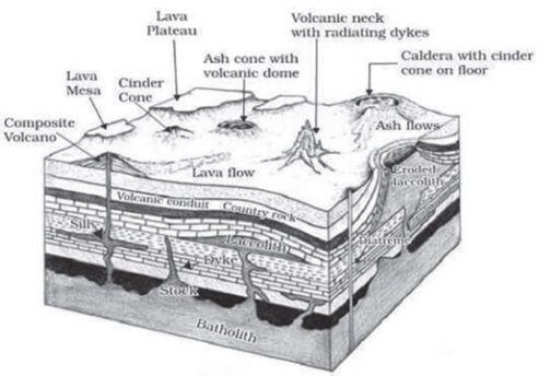
Intrusive volcanic landforms are geological features formed by the solidification of magma beneath the Earth’s surface. Unlike extrusive volcanic landforms, which are created by volcanic activity on the surface, intrusive landforms are formed when magma cools and solidifies within the Earth’s crust. These landforms exhibit various shapes and structures depending on the cooling process, depth, and composition of the magma.
1. Batholith:
Definition: A batholith is a massive body of granitic rock that forms deep within the Earth’s crust.
Formation: Batholiths develop from the slow cooling of magma chambers deep beneath the surface. Over time, as the overlying rocks erode, these large bodies of intrusive igneous rocks are exposed.
Characteristics: They often form the cores of mountain ranges and are characterized by their massive size and domal shapes.
Example: The Sierra Nevada Batholith in California is one of the largest batholiths in the world.
2. Laccolith:
Definition: A laccolith is a type of intrusive structure characterized by a dome-shaped body with a level base.
Formation: It forms when magma intrudes between layers of sedimentary rock and causes the overlying layers to bulge upwards, creating a dome-shaped feature.
Characteristics: Laccoliths often have a central conduit or pipe-like structure connecting them to the magma chamber below.
Example: The Karnataka plateau in India features prominent domal hills formed by laccoliths of granite rocks.
3. Lapolith:
Definition: A lapolith is a saucer-shaped intrusive body formed by the horizontal movement of magma.
Formation: It occurs when magma intrudes between layers of existing rock and spreads out horizontally, creating a concave-shaped body.
Characteristics: Lapoliths are often concave upwards, resembling a saucer or shallow basin.
Example: Lapoliths are less common compared to other intrusive landforms, but examples can be found in various geological settings.
4. Phacolith:
Definition: A phacolith is a wavy-shaped intrusive rock structure found at the base of synclines or the top of anticlines in folded igneous rock.
Formation: Phacoliths form as a result of the plastic deformation of rocks during tectonic processes, such as folding.
Characteristics: They exhibit a characteristic wave-like shape and are often associated with folded rock formations.
Example: Phacoliths are commonly observed in regions with intense tectonic activity, such as mountain belts.
5. Sill:
Definition: A sill is a tabular, horizontal intrusive body of igneous rock that forms between layers of existing rock.
Formation: Sills are formed when magma is injected into horizontal fractures or bedding planes within the Earth’s crust and solidifies.
Characteristics: Sills have a flat or gently inclined orientation and can vary in thickness from meters to hundreds of meters.
Example: The Palisades Sill in the northeastern United States is a well-known example of a prominent sill formation.
6. Dyke:
Definition: A dyke is a vertical, sheet-like intrusive body of igneous rock that cuts across existing rock layers.
Formation: Dykes form when magma is injected into vertical fractures or fissures within the Earth’s crust and solidifies.
Characteristics: Dykes are typically oriented perpendicular to the bedding planes of the surrounding rocks and can range in width from centimeters to several meters.
Example: The Giant’s Causeway in Northern Ireland features spectacular basalt dykes cutting across the coastal landscape.
Hot Springs and Geysers
Introduction:
Hot springs and geysers are fascinating natural phenomena formed by the interaction of groundwater with high-temperature magma reservoirs or solidified igneous rock at shallow depths. This interaction results in the heating of groundwater, making it less dense and causing it to rise towards the surface through cracks and fissures. Both hot springs and geysers are manifestations of this geological process, offering unique landscapes and experiences for visitors worldwide.
Hot Springs: Hot springs are areas where warm groundwater, heated by geothermal energy, pools on the ground’s surface. They are characterized by several distinct features:
- Formation: The warm groundwater rises due to geothermal heating, creating pools on the surface.
- Steam Emission: As the heated water approaches the surface, it often emits steam due to the stark temperature contrast.
- Colorful Cyanobacteria: The presence of colorful cyanobacteria often gives hot springs their vibrant hues, adding to their visual appeal.
- Examples: Notable examples of hot springs include Tattapani in Himachal Pradesh, India, and Mammoth Hot Springs in Yellowstone National Park, Wyoming, USA.
Geysers: Geysers are a specific type of hot spring characterized by intermittent, forceful eruptions of water and steam. They exhibit several distinctive features:
- Underground Boiling: Geysers keep water boiling underground due to the high geothermal energy present. This continuous heating builds pressure, which eventually leads to eruptions.
- Pressure Buildup: The pressure created underground causes water to rise out of the ground spontaneously, resulting in the geyser’s characteristic eruptions.
- Intermittent Discharge: Geysers eject water turbulently and intermittently, with varying periods between eruptions.
- Steam Accompaniment: Alongside water, geysers often eject steam, adding to the spectacle of their eruptions.
- Example: One of the most famous geysers is Old Faithful Geyser in Yellowstone National Park, USA, renowned for its predictability and impressive eruptions.
Hotspot and Mantle Plumes
Hotspot volcanism is a distinct geographical phenomenon that diverges from traditional volcanism, which typically occurs at the margins of tectonic plates. Unlike these boundary-driven volcanic activities, hotspot volcanism is characterized by its occurrence away from plate boundaries, within the interior of the lithospheric plates. This process is fundamentally driven by hotspots, which are exceptionally hot areas located in the Earth’s mantle.
- Understanding Hotspots
- A hotspot is essentially a localized zone within the Earth’s mantle from which hot plumes of mantle material rise through convection currents. These rising plumes reach the lithosphere, the rigid outer layer of the Earth, causing partial melting of rocks at the base. The molten rock, or magma, thus formed can force its way through cracks and fissures in the crust, leading to the formation of volcanoes on the surface. Notable examples of hotspot volcanism include the Hawaiian Volcanic Hotspot, Yellowstone Volcanic Hotspot, and the Reunion Volcanic Hotspot.
- Mantle Plumes: The Driving Force
- Mantle plumes are the underlying drivers of hotspot volcanism. They are thermal anomalies found deep beneath the Earth’s crust, characterized by a structure that includes a bulbous head and a narrow tail. These plumes originate from deep within the mantle and rise toward the surface. As the head of a plume approaches the lithosphere, its heat causes substantial melting of the surrounding mantle material, creating a large volume of basaltic magma. This magma can then ascend to the surface, often resulting in volcanic eruptions.
- Diapirs
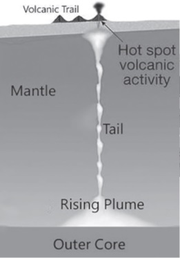
- As mantle plumes make their way upwards, they can form diapirs — mushroom-shaped features created when the plume head distorts the lithosphere. This interaction between the plume head and the base of the lithosphere is crucial for the formation of a hotspot, as it facilitates the melting process and the eventual eruption of magma.
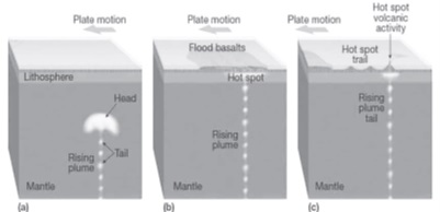
- Dynamics of Hotspots and Volcanic Chains
- One of the hallmark characteristics of hotspot volcanism is the relative stationarity of hotspots in comparison to the moving lithospheric plates above them. This dynamic leads to the creation of chains of volcanic islands or seamounts as the plate moves over a stationary hotspot. As old volcanoes are moved away, new ones are formed in their place. The Hawaiian Islands are a classic example of such a process, illustrating how the movement of the Pacific Plate over the Hawaiian hotspot has created a sequential chain of volcanic islands.
- Volcanic Activity and Seamounts
- Besides island chains, hotspot volcanism can also result in the creation of seamounts — submarine mountains formed by volcanic activity. These features further underscore the significant impact of hotspot volcanism on shaping the Earth’s topography, both above and below the waterline.
- Hotspots Beneath Continental Plates
- While many hotspots are found beneath oceanic plates, leading to the formation of island chains and seamounts, they can also develop under continental plates. The Yellowstone hotspot, located beneath the North American Continental Plate, is a prime example. This hotspot is responsible for the geothermal features and volcanic activity observed in the Yellowstone National Park.
Volcanoes in India
India’s geological landscape is diverse, featuring a range of geological formations from the ancient cratons to the youthful Himalayan range. However, volcanic activity is relatively rare, with the notable exceptions of Barren Island and Narcondam Island in the Andaman and Nicobar Islands.
1. Barren Island Volcano
- Location: Situated in the Andaman Sea, Barren Island is a part of the Andaman and Nicobar Islands, a Union Territory of India. This island is approximately 138 km northeast of the territory’s capital, Port Blair.
- Status: Barren Island hosts the only active volcano not just in India but in the entire South Asian region. Its geographical isolation in the Andaman Sea contributes to its unique ecological and geological characteristics.
- Eruptions: The volcano on Barren Island has had a history of eruptions. While the prompt mentions the last eruption in 1995, it’s important to note that there have been several eruptions since then, including activity observed in the early 21st century. These eruptions have been characterized by both explosive activity and the effusion of lava flows.
- Ecological Impact: Despite its name, Barren Island supports a variety of life forms, including some specialized fauna and flora adapted to its volcanic environment. The eruptions have played a role in shaping the ecosystem of the island.
2. Narcondam Island Volcano
- Location: Narcondam Island is located about 150 km northeast of Barren Island in the Andaman Sea. This places it further away from the Indian mainland, towards the eastern boundary of the Andaman and Nicobar Islands.
- Status: The volcanic island of Narcondam is considered extinct. There have been no recent eruptions or volcanic activity recorded on the island, indicating a long period of dormancy.
- Ecological Significance: Despite its volcanic origin, Narcondam Island is known for its rich biodiversity, including several endemic species. The island’s ecosystem is protected as a wildlife sanctuary, highlighting its importance for conservation.
Absence of Volcanoes in the Himalayan Range and Indian Peninsula
- Himalayan Range: The Himalayas, formed from the collision of the Indian Plate with the Eurasian Plate, are primarily known for their seismic activity rather than volcanic. The process of plate tectonics responsible for the formation of the Himalayas does not favor the conditions necessary for volcanic activity in this region.
- Indian Peninsula: The Indian Peninsula is characterized by ancient geological formations, including the Deccan Plateau, known for its Deccan Traps – extensive basalt flows from one of the largest volcanic eruptions in Earth’s history. However, these are considered to be remnants of past volcanic activity that occurred around 65 million years ago, and there are no active volcanoes in this region.
Distribution of Volcanoes Across the World
The distribution of volcanoes across the world is a fascinating aspect of geology that reflects the dynamic processes occurring within the Earth’s crust. The global pattern of volcanic activity can largely be attributed to the movement and interaction of the Earth’s tectonic plates.
The Ring of Fire
- Description: The Ring of Fire is a major area in the basin of the Pacific Ocean where a large number of earthquakes and volcanic eruptions occur. It is a horseshoe-shaped zone that is approximately 25,000 miles long.
- Geographical Scope: This zone stretches from the southern tip of South America, up the West Coast of North America, through the Bering Sea, curves around Japan, and extends down to New Zealand.
- Volcanic Concentration: About 75% of the world’s active and dormant volcanoes are located in the Ring of Fire. This high concentration is due to the movement and interactions of several tectonic plates in the Pacific Ocean basin.
Tectonic Processes
- Convergence of Plates: The formation of many volcanoes around the Ring of Fire is attributed to the convergence of oceanic and continental plates. This process involves the collision of a denser oceanic plate with a lighter continental plate, leading to the subduction of the oceanic plate beneath the continental plate.
- Subduction Zones: These are areas where one tectonic plate moves under another and sinks into the mantle as the plates converge. The descending plate melts, and the magma rises to form volcanoes.
- Resultant Volcanism: The pressure and heat from the subducting plate cause the melting of mantle rock, creating magma that rises through the crust to the surface, resulting in volcanic eruptions.
Major Volcanic Eruptions
- Mount Etna, Sicily, Italy: One of the most active volcanoes in the world, known for its frequent eruptions.
- Mayotte Island, France, Western Indian Ocean: Experienced a significant seismic event in 2018, indicating volcanic activity.
- Mount Sinabung, Karo plateau of North Sumatra, Indonesia: Has become increasingly active since 2010 after centuries of dormancy.
- Mount Agung and Mount Soputan, Indonesia: Both have had recent eruptions, affecting local populations and air travel.
- Anak Krakatau Island, Indonesia: The site of the infamous Krakatoa eruption of 1883; continues to be active.
- Semeru Volcano, Indonesia: Known for its regular ash explosions and lava dome growth.
- Mount Nyaragonga, Democratic Republic of Congo (inside Virunga National Park): Known for its extremely fluid lava that can flow rapidly.
- Taal Volcano, Philippines: One of the country’s most active volcanoes, with a history of destructive eruptions.
- Kilauea Volcano, Hawaiian Islands, USA: One of the most active on Earth, Kilauea’s eruptions are often non-explosive but produce significant lava flows.
Volcanoes and the Environment
Volcanic eruptions are one of the most powerful demonstrations of nature’s force, significantly affecting the Earth’s environment and climate. These geological events not only reshape the landscape but also have profound impacts on the atmosphere, temperature, and air quality. Understanding these impacts is crucial for comprehending the broader implications of volcanic activity on our planet and its inhabitants.
Impact of Volcanic Eruption on Temperature
Volcanic eruptions can influence global temperatures through the emission of various substances, primarily sulfur dioxide (SO2), into the atmosphere. The process and effects of these emissions can be detailed as follows:
- Cooling Effect: When volcanic emissions, particularly sulfur dioxide, reach the stratosphere, they undergo a transformation that leads to a global cooling phenomenon. This process involves several steps:
- Conversion to Sulfuric Acid: Sulfur dioxide emitted by volcanoes converts into sulfuric acid (H2SO4) upon coming into contact with water vapor in the stratosphere.
- Formation of Sulfate Aerosols: The sulfuric acid rapidly condenses in the stratosphere to form fine sulfate aerosols. These aerosols are tiny particles or droplets suspended in the atmosphere.
- Increased Albedo: The sulfate aerosols increase the Earth’s albedo, which is the measure of how much solar radiation is reflected back into space. A higher albedo means more solar radiation is reflected, reducing the amount of heat absorbed by the Earth’s surface and lower atmosphere.
- Global Cooling: This increased reflection of solar radiation results in a cooling effect on the Earth’s lower atmosphere. Historical data shows that significant volcanic eruptions in the past century have led to a decrease in global temperatures by approximately 0.27°C, with these cooling effects lasting for about three years.
Impact of Volcanic Eruption on Pollution
Volcanic eruptions contribute to environmental pollution in several ways, primarily through the release of sulfur dioxide and particulate matter into the atmosphere:
- Higher Concentration of SO2 Emission: Volcanoes are a major natural source of sulfur dioxide emissions globally. This gas is significant because it plays a crucial role in several environmental issues, including the formation of acid rain.
- Acid Rain Formation: When sulfur dioxide combines with water vapor in the atmosphere, it forms sulfuric acid, contributing to acid rain. Acid rain can have harmful effects on plants, aquatic ecosystems, infrastructure, and soil chemistry.
- Higher Concentration of Particulate Matter: The reaction of sulfur oxides (SOx) with other chemical compounds in the atmosphere contributes to particulate matter pollution. Particulate matter, or PM, refers to a mixture of solid particles and liquid droplets found in the air.
- Health Impacts: Particulate matter, especially volcanic ash, can pose serious health risks. Inhalation of volcanic ash or fine particles can lead to respiratory problems, including bronchitis, exacerbation of asthma, and other pulmonary diseases. The size and composition of these particles determine their ability to cause health issues, with smaller particles being more harmful as they can penetrate deeper into the lungs.
Understanding the environmental impacts of volcanic eruptions is essential for preparing and mitigating their effects on climate, air quality, and public health. Continuous monitoring and research into volcanic activity help improve our readiness and response strategies to these natural events.
Pseudo Volcanic Landforms
To provide a more structured and detailed explanation of pseudo volcanic landforms, the following table organizes the information into categories for clarity. Pseudo volcanic landforms are those topographical features that mimic volcanic landforms but do not originate from volcanic activities. These features include meteorite craters, salt plugs or salt domes, and mud-volcanoes. Each of these has distinct formation processes and characteristics, as outlined below:
| Feature | Description | Formation Process | Examples |
| Meteorite Craters | Craters formed by the impact of a meteorite striking the Earth’s surface, often leading to the creation of a depression. When filled with water, these become crater lakes. | A meteorite impacts the Earth’s surface with enough force to create a depression. Over time, natural processes such as erosion and sedimentation can shape the crater, and rainwater accumulation can lead to the formation of a lake within the crater. | Lonar Lake, Maharashtra, India – A notable example created by a meteor impact during the Pleistocene Epoch. |
| Salt Plug or Salt Dome | Dome-shaped intrusions formed when underground salt deposits become ductile under high pressure and pierce through the overlying sediments, resembling a volcanic crater. | The buoyancy of salt causes it to flow upwards through the overlying rock layers, which are typically more brittle. This upward movement can create dome-like structures as the salt displaces the overlying sediments. | Salt domes in the Gulf Coast of the United States – Often associated with oil fields due to the trapping of petroleum by the salt structures. |
| Mud-Volcanoes | Eruptions of mud, water, and gases that mimic volcanic eruptions, leading to the formation of mud volcanic structures or domes. | Mud-volcanoes are typically found near subduction zones or hot springs. They form when pressurized gases and liquids, including methane and other hydrocarbons, force their way to the surface, carrying mud and debris with them. | Mud-volcanoes near oil fields – These often erupt with methane and other volatile hydrocarbon gases, commonly found in regions like Azerbaijan and Indonesia. |
These pseudo volcanic landforms provide important insights into the dynamic processes of the Earth’s crust, despite their non-volcanic origins. They also serve as significant geological features for study, offering clues about the Earth’s past environments, the movement and characteristics of the Earth’s crust, and the interaction between geological processes and biological systems.
UPSC PREVIOUS YEAR QUESTIONS
1. Discuss the internal structure of the Earth and comment on S and P-waves shadow zones with suitable diagrams. (2021)
2. The frequency of earthquakes appears to have increased in the Indian subcontinent. However, India’s preparedness for mitigating their impact has significant gaps. Discuss various aspects. (2015)
3. The annual range of temperature in the interior of the continents is high as compared to coastal areas. What is/are the reason/reasons? (2013)
1. Thermal difference between land and water
2. Variation in altitude between continents and oceans
3. Presence of strong winds in the interior
4. Heavy rains in the interior as compared to coasts
Select the correct answer using the codes given below.
(a) 1 only
(b) 1 and 2 only
(c) 2 and 3 only
(d)1, 2, 3 and 4
4. Consider the following statements: [2006]
1. The Richter scale is a logarithmic scale and so an increase of 1 magnitude unit represents a factor of 10 times in amplitude.
2. Each integer reading of the Richter scale has an energy 100 times that the previous integer reading.
Which of the statement(s) given above is/are correct?
(a) 1 only
(b) 2 only
(c) Both 1 and 2
(d) Neither 1 nor 2