GEOMORPHIC PROCESSES
Introduction
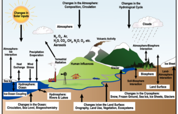
The Earth’s surface is an ever-changing landscape, molded and shaped by a complex interplay of forces both from within and without. This dynamic nature is a result of internal forces, driven by mantle convections beneath the Earth’s crust, and external forces, which originate within the Earth’s atmosphere. Together, these forces are the architects of the diverse landforms we observe on the planet’s surface, from towering mountains to deep ocean basins.
Geomorphic Processes
Definition and Drivers
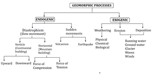
Geomorphology is the study of landforms and the processes that shape them. A geomorphic process refers to the physical and/or chemical changes that modify the landscape of the Earth’s surface. These processes are propelled by two primary forces: exogenic and endogenic.
Exogenic Forces
- Origin and Source: Exogenic forces are those that originate outside the Earth’s interior, mainly within its atmosphere. These forces are primarily powered, directly or indirectly, by the Sun.
- Actions and Effects: The primary actions of exogenic forces include the degradation (wearing down) of the Earth’s relief or elevations and the aggregation (filling up) of basins or depressions. Through these actions, exogenic forces play a crucial role in shaping the Earth’s surface by breaking down rocks and soil, transporting and depositing sediment, and contributing to the sculpting of the landscape.
- Processes: The processes driven by exogenic forces include weathering, erosion, transportation, and deposition. These processes work in tandem to remodel the Earth’s surface, leading to the formation of various landforms such as valleys, deltas, and beaches.
Endogenetic Forces
- Origin and Source: In contrast, endogenetic forces have their origins deep within the Earth. These forces are generated by the movement of convection currents in the mantle, the rotation of the Earth, and the heat produced by radioactive decay in the Earth’s interior.
- Actions and Effects: Endogenetic forces are responsible for processes that result in significant changes in the Earth’s landscape from within. These include the formation of mountains, the rift of continents, and the creation of volcanic and seismic activities.
- Processes: The key processes associated with endogenetic forces include tectonics (the movement of the Earth’s plates), volcanic activity, and seismic events (earthquakes). These processes can lead to the uplift of landforms, the creation of new landmasses, and the reconfiguration of the Earth’s crust.
- The Earth’s surface is a testament to the dynamic interplay of exogenic and endogenetic forces. Through the ongoing processes of wearing down and building up, the landscape of our planet is continually evolving. The study of these geomorphic processes not only helps us understand the physical changes our planet undergoes but also aids in predicting future transformations of the Earth’s surface.
Endogenic Processes
Endogenic processes, also known as internal or endogenetic processes, play a crucial role in shaping the Earth’s surface and its geological features. These processes originate from deep within the Earth and are powered by several sources of energy, including radioactivity, rotational and tidal friction, and primordial heat that has been present since the planet’s formation. Understanding these processes is essential for comprehending the dynamic nature of Earth’s geology and geography.
Endogenic Processes
Radioactivity: The decay of radioactive elements like uranium, thorium, and potassium in the Earth’s crust generates heat, contributing to the thermal energy within the Earth.
- Rotational and Tidal Friction: The gravitational interaction between the Earth and the Moon, as well as the Earth’s rotation, generates frictional heat. This interaction affects the distribution and intensity of endogenic processes.
- Primordial Heat: This is the residual heat from the Earth’s formation over 4.5 billion years ago. It accounts for a significant portion of the internal heat, driving many of the Earth’s endogenic activities.
Classification of Endogenic Processes
Endogenic processes are classified based on the intensity and speed of movement into two main categories: sudden movements and diastrophism.
Sudden Movements
Sudden movements are rapid processes that can significantly alter the Earth’s morphology in a relatively short period. These include:
- Volcanism: This involves the release of magma (when it’s below the Earth’s surface) or lava (once it reaches the surface) through a vent or fissure. Volcanism creates various landforms, including mountains, plateaus, and islands, and contributes to the renewal of the Earth’s surface by bringing deep-seated materials to the top.
- Earthquakes: Earthquakes occur due to the sudden release of accumulated energy in the Earth’s crust, resulting in seismic waves. These waves can cause significant changes to the Earth’s surface, affecting landscapes, structures, and human lives. Earthquakes highlight the dynamic nature of the planet’s crust and are closely monitored to understand and mitigate their impact.
Diastrophism
Diastrophism encompasses the slower, gradual movements of the Earth’s crust, which can lead to the creation of major landforms over long periods. This category includes:
- Orogenesis: The process of mountain building through the folding, faulting, and uplift of the Earth’s crust. This slow and continuous process can form mountain ranges and elevate landmasses.
- Epeirogenesis: Unlike orogenesis, epeirogenesis involves the broad, relatively uniform uplifting or subsiding of large sections of the Earth’s crust without significant folding or faulting. This can result in the formation of continents and ocean basins.
Constructive Forces
Both sudden movements and diastrophic processes are considered constructive forces because they create new geological features and landforms on the Earth’s surface. These processes contribute to the constant evolution of the Earth’s topography, creating a dynamic and ever-changing planet.
Diastrophic
- Nature: Slow, internal movements of the Earth’s crust.
- Impact: Responsible for creating major landforms like continents, mountains, and rift valleys.
- Characterization: Considered constructive forces due to their role in landform creation.
- Temporal Scale: Effects become noticeable over several years, highlighting the gradual nature of these processes.
Classification of Diastrophic Movements
Diastrophic movements are divided into two main categories based on their direction of movement and the geological features they influence:
- Epeirogenic Process (Continent Building Process)
- Orogenic Process (Mountain Building Process)
1. Epeirogenic Process
The epeirogenic process involves the vertical movement of the Earth’s crustal plates, driven by forces emanating from the planet’s interior. This process can lead to either the uplift (upward movement) or subsidence (downward movement) of the crust, affecting large areas and resulting in significant geological changes over time.
- Uplift and Subsidence: These movements are critical in the formation of continental and oceanic crust, respectively. Uplift can lead to the emergence of new land areas or the elevation of existing ones, while subsidence can result in the lowering of land areas or the creation of new oceanic basins.
- Characteristics: Known as radial movement, this process acts perpendicular to the Earth’s surface, moving either towards the Earth’s center (subsidence) or away from it (uplift). This vertical movement is essential for the long-term evolution of the Earth’s topography.
- Geological Impact: The epeirogenic process plays a pivotal role in the large-scale restructuring of the Earth’s surface, influencing the distribution of continents and oceans. It affects not only the shape and elevation of land masses but also has implications for climate change, sea level variations, and ecological systems.
2.Orogenic Process
The orogenic process is a fundamental geological phenomenon responsible for mountain formation through the interaction of the Earth’s crustal plates. This process, characterized by the horizontal movement of these plates, plays a crucial role in shaping the Earth’s topography, particularly in the creation of mountain ranges. The dynamics of plate movements under different forces lead to the formation of various types of mountains, which are essential in understanding the Earth’s geological history and landscape evolution.
- Definition: The orogenic process refers to the mechanisms involved in the formation of mountain ranges, including both block mountains and fold mountains.
- Mechanism: It involves the horizontal movement of the Earth’s tectonic plates.
Types of Plate Movements in Orogenic Process
The orogenic process can be divided based on the nature of the force acting between the plates, leading to different geological structures:
1. Divergent or Tensional Force
- Description: Plates moving in opposite directions.
- Consequences: This movement is responsible for creating faults, rifts, and block mountains. Rift valleys and block mountains are classic examples of landscapes formed by such forces, where the Earth’s crust is stretched thin and breaks, creating a distinct topography.
2. Convergent or Compressional Force
- Description: Plates moving toward each other.
- Consequences: The collision or compression of these plates leads to the formation of fold mountains. Fold mountains are created when the crust is compressed and forced upwards, forming complex and often large mountain ranges. This process is responsible for some of the world’s highest and most well-known mountain ranges, including the Himalayas.
Geological Impact and Examples
- Block Mountains: Formed by the tensional forces that pull the crust apart, causing blocks of the crust to drop down between parallel faults. An example is the Basin and Range Province in the western United States.
- Fold Mountains: Result from the compressional forces that squeeze the crust into folds. The Himalayas, Andes, and Alps are prime examples of fold mountains formed by the collision of continental plates.
| Feature | Epeirogenic Movement | Orogenic Movement |
| Movement Direction | Vertical | Horizontal |
| Main Actions | Involves upliftment or subsidence | Involves forces of compression or tension |
| Geological Impact | Responsible for the formation of continents | Responsible for folding, faulting, and mountain building |
Fold Mountains
Fold mountains represent some of the Earth’s most spectacular landscapes, formed through the dynamic processes of plate tectonics. These mountains are created when two lithospheric plates converge, applying compressional forces that fold the crust into wave-like structures. The complexities of these structures and their formation processes are fundamental to understanding the Earth’s geomorphology.
Understanding Folds
- Folds are undulating structures that occur when the Earth’s crust is subjected to compressional forces. These forces cause the crust to buckle and fold, similar to how a rug might wrinkle when pushed from two ends.
- The limbs of a fold refer to its two sides, which can vary in steepness and orientation depending on the type of fold.
- Anticlines are upward folds where the oldest rocks are at the core, resembling an arch.
- Synclines are the opposite, downward folds, with the youngest rocks located at their center.
Types of Folds
- Symmetrical Folds: Both limbs of the fold mirror each other in slope and length.
- Asymmetrical Folds: One limb is steeper or longer than the other, creating an imbalanced structure.
- Isoclinal Folds: Characterized by limbs that are almost parallel to each other, indicating a very tight fold.
- Recumbent Folds: These folds are tipped over to the extent that their limbs are almost horizontal.
- Overturned Folds: A fold where one limb is pushed over the other, making it highly inclined or even flipped over the axial plane.
- Plunging Folds: These folds have a tilt along their axis, causing the structure to plunge into the Earth at an angle.
- Open Fan Folds: The limbs of the fold form an obtuse angle, creating a gentle, broad structure.
- Closed Folds: The limbs form a sharp angle, typically between 70° to 30°, creating a tighter structure.
Fold Mountains
- Formation: Fold mountains are primarily formed at convergent plate boundaries, where the collision of lithospheric plates exerts compressional forces on the crust. This process leads to the folding of the Earth’s crust and the upliftment of mountain ranges.
- Characteristics: These mountains are characterized by their grand scale, featuring high peaks and narrow widths. The folding process results in a complex structure of anticlines and synclines, contributing to the mountainous terrain.
- Seismic Activity: Due to their formation along tectonically active boundaries, fold mountains are often associated with seismic activity, including earthquakes.
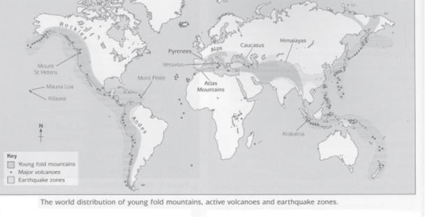
- Examples: Some of the most well-known fold mountains include the Himalayas in Asia, the Rockies in North America, the Alps in Europe, the Atlas Mountains in Africa, and the Andes in South America.
Classification
Fold mountains can be classified based on various criteria, including their age, the intensity of the folding process, and the nature of the lithospheric plates involved (continental or oceanic). However, the specific classification criteria were not detailed in the initial request.
| Classification Basis | Type | Characteristics | Examples |
| Nature of Folds | Simple Folded Mountains | Characterized by a well-developed system of anticlines and synclines. | |
| Complex Folded Mountains | Exhibit complex folds due to extreme compressional force. | Himalayas | |
| Period of Origin | Old Fold Mountains | Formed in the Tertiary period and before, now eroded over time to become residual fold mountains. | Aravali Range (India) |
| New Fold Mountains | Formed in the Tertiary period, still in the process of formation, with heights increasing annually. Classified further into Andean and Himalayan types. | ||
| – Andean Type | Formed by oceanic-continental convergence, prone to volcanic and seismic activity. | Rockies, Andes | |
| – Himalayan Type | Formed by continental-continental convergence, no volcanic activity but may find marine sediments due to geosyncline. | Great Himalayas |
Block mountains
Block mountains, also known as fault-block mountains, are significant landforms shaped by the processes of faulting, which is a result of endogenic forces acting on the Earth’s crust. These forces can be either tensile, leading to the stretching and fracturing of the crust, or compressional, pushing crustal blocks against each other. The detailed mechanics and classifications of faults, as well as the formation of block mountains and related structures like rift valleys, are crucial to understanding Earth’s dynamic crust.
Faults and Their Formation
Faults are fractures in the Earth’s crust where significant displacement of lithospheric plates has occurred. These displacements result from the actions of tensile (stretching) and compressional (squeezing) forces exerted by endogenic processes within the Earth. The plane along which these displacements occur is referred to as the fault plane.
Types of Faults
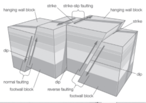
- Normal Faults: These occur when the crust is under tension, causing lithospheric plates or crustal blocks to move apart. One block moves downward relative to the other, creating space that can lead to the formation of rift valleys or the dropping of a block to form one side of a block mountain.
- Reverse Faults (or Thrust Faults): Characteristic of compressional force areas, these faults result when one block moves up and over another along the fault plane. The block above the fault plane (the hanging wall) moves upward compared to the block below (the footwall), often leading to the creation of mountainous structures.
- Strike-slip Faults: These occur when lithospheric plates slide horizontally past one another along the fault plane, without significant upward or downward movement. They can be right-lateral or left-lateral, depending on the direction of the displacement.
Block Mountains (Fault Mountains)
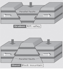
Block mountains arise when the Earth’s crust is stretched due to tensile forces, leading to the formation of normal faults. This process can cause the crust to break into blocks, which can either uplift to form mountains (Horsts) or subside to form valleys (Grabens).
- Horst: An uplifted block of crust situated between two normal faults. The elevation of the horst forms a mountain or mountain range.
- Graben: A depressed block of crust that sinks between two normal faults, often forming a rift valley.
Rift Valleys
Rift valleys are lowland regions that form when tectonic plates move apart. This rifting can be the result of the same tensile forces that create normal faults and, consequently, block mountains. The movement apart of the plates causes the crust to stretch and thin, eventually leading to the formation of a graben.
Examples of Rift Valleys and Block Mountains
- Great African Rift Valley: An example of a graben, formed by the rifting and separation of the African Plate.
- Rhine Valley, Europe: Another example of a graben, formed by the stretching and subsiding of the Earth’s crust in the region.
- Block mountains and rift valleys are not only fascinating geological features but also provide insights into the dynamic processes shaping our planet’s surface. They affect the distribution of ecosystems, influence climate patterns, and have significant implications for human activities, such as agriculture, settlement, and resource extraction. Understanding these natural structures helps in planning and managing the environment and resources more effectively.
The Great Rift Valley System
The Great Rift Valley System is a monumental geological feature that stretches over thousands of kilometers from the Middle East, specifically from Lebanon, through Eastern Africa, and down to Mozambique in the south. This system is a testament to the dynamic nature of the Earth’s lithosphere, illustrating the processes of continental rifting, plate tectonics, and the potential for creating new ocean basins.
The Great Rift Valley System
- Geographical Span: The Great Rift Valley System extends over 6,000 kilometers in length, traversing diverse terrains and ecosystems across several countries from the Middle East to Southeastern Africa.
- Formation: The formation of the Rift Valley System is the result of tectonic forces pulling the Earth’s crust apart, a process known as rifting. This has led to the development of a series of rift valleys, characterized by elongated depressions flanked by highlands or mountain ranges.
East African Rift (EAR)
The EAR is a significant segment of the Great Rift Valley System and serves as a prime example of an active continental rift zone. It is here that the processes of continental rifting can be observed in real-time.
- Active Continental Rift: Unlike passive rifts, the EAR is active, indicated by ongoing tectonic activities such as earthquakes and volcanic eruptions. This activity is a direct consequence of the African continent being pulled apart.
- Diverse Geological Ages: The rift exhibits variability in geological activity and features along its length. The southern part of the rift is considered younger, with limited volcanic activity and seismic events. In contrast, the northern reaches of the rift are characterized by extensive volcanic rock cover, indicating a higher degree of volcanic activity.
- Tectonic Plate Formation: The rifting process is gradually splitting the African continent into two separate tectonic plates – the Somali Plate to the east and the Nubian Plate to the west. This separation occurs at an average rate of 6-7 millimeters per year.
- Future Ocean Basin: Geological predictions suggest that, given the current rate of rifting, the Somali Plate will eventually break away completely to form a new ocean basin within the next 10 million years. This significant event will alter the geography and potentially the climate of the region.
Implications and Significance
- Geological Research: The EAR offers invaluable insights into the processes of continental rifting, plate tectonics, and the formation of geological features. It serves as a natural laboratory for scientists studying the Earth’s dynamic crust.
- Biodiversity and Ecosystems: The diverse landscapes created by the rifting process, including mountains, lakes, and valleys, support a wide range of ecosystems and biodiversity, making the area a focal point for ecological and environmental research.
- Socio-Economic Impact: The geological activity associated with the EAR affects the lives of millions living in its vicinity. Earthquakes and volcanic eruptions pose natural hazards, while the rift’s unique landscapes offer opportunities for tourism and geothermal energy development.
The Great Rift Valley System, with the East African Rift at its core, is a striking feature of the Earth’s surface that highlights the planet’s geological complexity and the ever-changing nature of its crust. Through continued study and observation, we gain not only a deeper understanding of our planet’s past but also insights into its future transformation.
Mountains are Classified on the Basis of their Location as Follows
Mountains can be categorized based on their location and formation processes into two main types: Continental and Oceanic mountains. Each category has its unique characteristics, formation process, and examples from around the world.
Continental Mountains
Continental mountains are found on the continents and are typically the result of tectonic plate movements, including collision, subduction, and the folding of the Earth’s crust. They can be further classified based on their proximity to coastlines or their location within the continental interior.
Coastal Mountains
These are mountains that are located near the coastlines. They are often formed by the collision of oceanic and continental tectonic plates, leading to the uplift of mountain ranges.
| Mountain Range | Location | Characteristics |
| The Rockies | North America | Known for their high peaks and extensive range, formed by tectonic activity and volcanic processes. |
| The Appalachians | Eastern USA | Older, eroded, and characterized by rounded mountains, formed by ancient collisions of continents. |
| The Alpine mountain chains | Europe | Young, high, and rugged mountains formed by the collision of the African and Eurasian plates. |
| The Western Ghats | India | Run parallel to India’s western coast, a biodiversity hotspot with significant ecological importance. |
| The Eastern Ghats | India | Less continuous and lower than the Western Ghats, with important river basins and unique flora. |
Inland Mountains
These mountains are located away from the coastal areas, often in the interiors of continents. They can form through various processes, including the uplift of the Earth’s crust without direct influence from oceanic plate interactions.
| Mountain Range | Location | Characteristics |
| The Vosges and the Black Forest | Europe | Characterized by dense forests and rounded peaks, formed by ancient tectonic activities. |
| The Kunlun, Tienshan, Altai | Asia | Part of the complex mountain systems of central Asia, with significant elevation and geological diversity. |
| The Urals | Russia | Form a natural boundary between European and Asian Russia, one of the oldest ranges with rich mineral deposits. |
| The Aravallis, the Himalayas, the Satpura, and the Maikal | India | The Himalayas are the youngest and highest, while the Aravallis are among the oldest. Each has significant geological and ecological importance. |
Oceanic Mountains
Oceanic mountains are primarily found in the ocean and are usually volcanic in origin. They can form from volcanic activity on the ocean floor or from hotspots within the Earth’s mantle.
| Mountain Range | Location | Characteristics |
| Mauna Kea | Hawaii | A dormant volcano that is considered the tallest mountain on Earth when measured from its base on the ocean floor to its summit. |
| Chain of volcanic mountains in Hawaii | Hawaii | Includes active and dormant volcanoes, formed by the Pacific Plate moving over a volcanic hotspot. |
This classification highlights the diversity of mountain types and their formation processes, reflecting the dynamic nature of Earth’s geology.
Significance of mountains
Mountains play a crucial role in shaping the environment, economies, and societies around the globe. Their significance spans across various aspects, from climatic influences to being pivotal sources of water, energy, and livelihood.
Natural Barrier
- Example: The Himalayas
- Impact: The Himalayas, extending across five countries in Asia, act as a formidable natural barrier. They shield the South Asian subcontinent from the cold polar winds coming from the north, significantly influencing the region’s climate. This barrier effect contributes to the monsoon weather patterns observed in South Asia, bringing precipitation essential for the region’s agriculture and water supply.
Storehouse of Water
- Examples: Origin of major rivers such as the Indus, Ganga, and Brahmaputra
- Impact: Mountains are often referred to as “water towers” for the world due to their role in storing snow and ice, which melt and feed rivers. The glaciers and snowfields of mountain ranges like the Himalayas are the source of major rivers that provide fresh water for drinking, irrigation, and sanitation for billions of people. This water is not only crucial for human consumption but also supports biodiversity and ecosystems in these river basins.
Energy Resources
- Impact: Mountains have a high potential for hydroelectric power generation due to their steep gradients and abundant water flow. Countries exploit this potential by constructing dams and hydroelectric power plants, which provide a renewable source of energy. This form of energy is cleaner and more sustainable than fossil fuels, contributing to the reduction of greenhouse gas emissions and helping in the fight against climate change.
Livelihood for Nomads
- Impact: For centuries, mountains have been home to nomadic communities who move seasonally with their herds. These regions offer pasture for livestock during the warmer months. Nomads depend on mountains for shelter, water, and fodder for their animals, such as sheep, goats, and yaks. This way of life is deeply integrated with the cultural heritage of many mountain regions, contributing to biodiversity conservation through traditional grazing practices.
Exogenic processes
Exogenic processes are a fundamental aspect of the Earth’s geomorphological dynamics, influencing the formation, alteration, and degradation of the planet’s surface features. These processes are primarily external, occurring at or near the Earth’s surface, and are chiefly driven by various geomorphic agents such as water, wind, and ice. The Sun, as the primary source of energy, plays a crucial role in powering these processes, contributing to the Earth’s weather patterns, climate variations, and the overall energy balance that drives geomorphic activities.
1. Exogenic Processes
Exogenic processes are external forces that shape the Earth’s surface by breaking down and transporting material. Unlike endogenic processes, which originate within the Earth and include tectonic activities and volcanic eruptions, exogenic processes work on the Earth’s surface, modifying landscapes formed by endogenic forces. The interaction between exogenic and endogenic processes creates a dynamic equilibrium, constantly reshaping the Earth’s surface features.
2. Denudational Processes
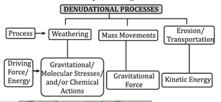
Denudation refers to the combined effect of processes that remove layers of the Earth’s surface horizontally, stripping it of soil, rock, and other materials. This concept encompasses several key processes:
- Weathering: The breakdown of rocks and minerals at the Earth’s surface through physical disintegration and chemical decomposition.
- Mass Movement/Wasting: The downward movement of soil and rock under the influence of gravity.
- Erosion: The removal and transportation of surface material by geomorphic agents like water, wind, and ice.
- Transportation: The movement of eroded material from its original site to a new location.
3. Factors Influencing Denudation
The intensity and impact of denudational processes are influenced by various factors, including:
- Stress: The internal force per unit area within materials, which plays a significant role in the fracturing and deformation of rocks.
- Shear Stress: A type of stress that acts parallel to the surface, contributing to the breaking and displacement of rock materials.
- Temperature and Precipitation: These climatic factors induce thermal expansion and contraction in rocks, leading to physical weathering. Precipitation, through chemical reactions, also facilitates chemical weathering and erosion.
4. Weathering
Weathering is a pivotal process within the spectrum of denudational activities. It is the initial stage of breaking down rock, setting the stage for erosion and mass movement. Weathering can be classified into three main types based on its nature:
- Physical Weathering: The mechanical breakdown of rocks into smaller pieces without changing their chemical composition. Factors such as temperature changes, frost action, and salt crystal growth contribute to this process.
- Chemical Weathering: The chemical alteration of rock materials due to reactions with water and gases in the atmosphere. This type of weathering transforms minerals into new compounds, facilitating their dissolution or creating new, weaker materials.
- Biological Weathering: The breakdown of rocks by biological activities, such as the growth of plant roots in cracks and the production of acids by living organisms, which can dissolve rock materials.
- Exogenic processes play a crucial role in shaping the Earth’s surface, interacting with endogenic forces to create the dynamic and ever-changing landscapes we observe. Understanding these processes is essential for comprehending the Earth’s geomorphological evolution and the interplay between the planet’s internal and external forces.
Chemical Weathering
The concept of chemical weathering can be detailed in a structured table format to enhance understanding. This process involves the decomposition of rocks through chemical reactions in the presence of water and air.
| Type | Process Description | Effects on Rocks | Examples |
| Solution | Material dissolves in water, either forming an acidic solution or when carbon dioxide is dissolved, leading to acidic conditions. | Minerals in rocks dissolve, leaching out without leaving a residue, especially in rainy climates. | Weathering of phosphate and sulfate rocks. |
| Carbonation | Minerals in rocks react with carbonic acid, formed when water combines with carbon dioxide in the atmosphere. | Breaks down and dissolves minerals, leading to the formation of karst landscapes. | Weathering of limestone. |
| Oxidation and Reduction | Involves the combination of minerals with oxygen (oxidation) and the removal of oxygen (reduction). | Causes rock breakdown due to disturbance from addition or removal of oxygen, facilitating further physical weathering. | Rusting of iron-bearing rocks. |
| Hydration | Chemical addition of water molecules to minerals. | Minerals expand, causing a change in volume and aiding physical weathering through repeated cycles of hydration and dehydration. | General effect on silicate minerals. |
| Chelation | Organic agents (e.g., peptides and sugars) decompose minerals and rocks by removing metallic ions. | Leads to the breakdown of rocks by the removal of metallic ions, contributing to soil formation. | Decomposition of minerals by organic acids. |
This table summarizes the main processes and effects of chemical weathering, illustrating how various chemical reactions contribute to the decomposition of rocks and minerals. Each type plays a crucial role in shaping the Earth’s surface, leading to the formation of different geological features and contributing to soil development.
Physical Weathering
Physical weathering is a critical geomorphological process that leads to the disintegration of rocks without altering their chemical composition. It is primarily driven by the physical forces of nature, including temperature fluctuations, water, ice, and gravitational stress. This process plays a significant role in shaping the Earth’s surface by breaking down rocks into smaller particles, which can then be transported and deposited by other forces such as water, wind, and ice. The types of physical weathering are diverse, each with its mechanisms and effects on the landscape.
1. Unloading and Expansion
- Mechanism: This type of physical weathering occurs when the overlying pressure exerted by rock layers is removed, often due to erosion. The reduction in pressure allows the rock beneath to expand and fracture.
- Effects:
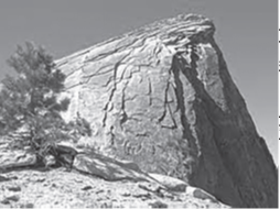
- Exfoliation: The expansion causes the outer layers of rock to peel away in sheets, a process known as exfoliation.
- Exfoliation Domes: Over time, this can result in the formation of large, smooth, dome-shaped rock structures known as exfoliation domes, commonly observed in granite landscapes.
2. Granular Disintegration
- Mechanism: In granular disintegration, the individual mineral grains of a rock become loosened and separate from the main body of the rock.
- Effects: This leads to the weakening of the rock’s structure, making it more susceptible to further weathering and erosion processes.
3. Exfoliation
- Mechanism: Exfoliation is closely related to diurnal temperature variations. Rocks heat up and expand under the sun during the day and cool down and contract at night.
- Effects:
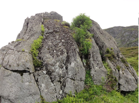
- Exfoliated Tors: The repeated expansion and contraction cause the rock to fracture and peel off in layers, forming structures known as exfoliated tors.
- This process is particularly effective in dry climates with significant temperature differences between day and night.
4. Freezing, Thawing, and Frost Wedging
- Mechanism: Water seeps into cracks and pores in the rock during warmer weather. When temperatures drop, the water freezes and expands, exerting pressure on the rock.
- Effects: The cycle of freezing and thawing can cause the rock to crack and eventually break apart, a process known as frost wedging.
5. Block Separation
- Mechanism: This process involves the splitting of rock along its natural joints or fractures due to thermal stress or the freeze-thaw cycle.
- Effects: The rock is broken down into distinct blocks, often resulting in angular and geometric rock formations.
6. Shattering
- Mechanism: Shattering occurs when a rock is fractured along its weaknesses, such as faults or joints, due to physical stress.
- Effects: The result is the creation of sharp, angular rock fragments, which can be further broken down by other weathering processes.
7.Salt Weathering or Haloclasty
- Mechanism: Salt weathering occurs when salt solutions seep into rocks and then evaporate, leaving salt crystals behind. These crystals grow and exert pressure on the rock from within.
- Effects:
- Crystallization and Hydration: The growth of salt crystals can cause the rock to fracture and disintegrate. This process is exacerbated by the hydration of salts, which further increases their volume and the pressure exerted on the rock.
- Salt weathering is particularly prevalent in arid and coastal environments where evaporation rates are high.
Physical weathering is a foundational process in geomorphology, contributing to soil formation, landscape evolution, and the rock cycle. By understanding the mechanisms and effects of physical weathering, we can better appreciate the dynamic and ever-changing nature of our planet’s surface.
Biological Weathering
Biological weathering is a critical process in the earth’s geological cycle, involving the breakdown of rocks and minerals by the activities of living organisms. This form of weathering contributes significantly to soil development, landscape formation, and the cycling of nutrients within ecosystems.
Mechanisms of Biological Weathering
Biological weathering occurs through several key mechanisms:
- Removal of Mineral Ions: Organisms such as plants, fungi, and bacteria can extract minerals from rocks for their metabolic processes, leading to the gradual disintegration of these rocks.
- Physical Disruption by Animals: Activities of animals, including burrowing and wedging by small mammals, insects, and other burrowers, mechanically break down rocks and expose new surfaces to further weathering processes.
- Human Activities: Agricultural practices, such as ploughing and cultivation, significantly disturb the soil and rock layers, enhancing their exposure to chemical and physical weathering agents.
- Plant and Fungal Growth: The growth of plant roots and fungal hyphae into cracks and crevices in rocks exerts physical pressure, leading to the mechanical breakup of the rock material. This process is sometimes referred to as root wedging or fungal weathering.
Significance of Biological Weathering
Biological weathering plays a pivotal role in several natural processes:
- Soil Formation: It is a primary contributor to the initial stages of soil formation, breaking down parent rock material into smaller particles that mix with organic matter to form soil.
- Nutrient Cycling: By breaking down rocks, essential minerals and nutrients are released into the soil, becoming accessible to the ecosystem and promoting biodiversity.
- Ore Enrichment: Certain types of biological weathering can lead to the enrichment and concentration of valuable ores, such as iron, manganese, and copper, making them more accessible for extraction.
Effects of Biological Weathering
The impact of biological weathering extends to the formation of various landforms and geological structures:
- Formation of Landforms: Over long periods, weathering contributes to the development of distinct landforms, such as peneplains – extensive, nearly level surfaces that result from the prolonged action of weathering and erosion.
- Creation of Tors: Differential weathering, where softer strata are eroded away, leaving behind exposed domes of harder rock, results in the formation of tors. These distinctive features add to the diversity of landscapes.
- Biological weathering is a fundamental geological process driven by the activities of living organisms. It influences soil formation, ecosystem nutrient cycling, and the creation of various landforms. Understanding the mechanisms and effects of biological weathering is crucial for comprehending the complex interactions between the biosphere and geosphere, highlighting the interconnectedness of life and the earth’s physical environment.
Mass movement
Mass movement, also known as mass wasting, is a significant geomorphological process that involves the movement of soil, rock, and debris down a slope due to the force of gravity. This process is distinct from erosion, which involves the action of external agents such as water, wind, and ice in removing material from the surface. Mass movement is a direct and internal process that does not require the participation of these geomorphic agents.
1. Nature and Mechanism of Mass Movement
Mass movement occurs when the gravitational force acting on a slope exceeds the resistance of the materials on that slope. This balance can be disrupted by various factors, leading to the downward movement of material. The resistance to movement is primarily provided by the internal friction and cohesion of slope materials, as well as the mechanical interlocking of particles.
2. Factors Influencing Mass Movement
Several factors can precede or contribute to mass movements, each affecting the stability of slopes in different ways:
- Increase in Gradient or Slope: Steeper slopes are more susceptible to mass movement due to the increased gravitational force acting on them.
- Removal of Base Support: Erosion or human activities at the base of a slope can remove support, making the slope unstable.
- Heavy Rainfall and Lubrication: Water from rainfall can infiltrate soil and rock, reducing friction and acting as a lubricant, facilitating movement.
- Removal of Material Load from Above: Quarrying, mining, and other excavation activities can destabilize slopes.
- Deforestation and Overgrazing: Vegetation helps to stabilize slopes. Its removal can increase the risk of mass movement.
- Earthquakes: Seismic activity can shake loose materials on slopes, triggering mass movements.
3. Role of Weathering
While weathering itself is not a direct cause of mass movement, it plays a significant role by weakening slope materials. Weathering processes break down rocks and minerals, reducing cohesion and increasing susceptibility to movement under gravitational forces.
4. Classification of Mass Movements
Mass movements can be classified based on their speed, type of material moved, and how the movement occurs:
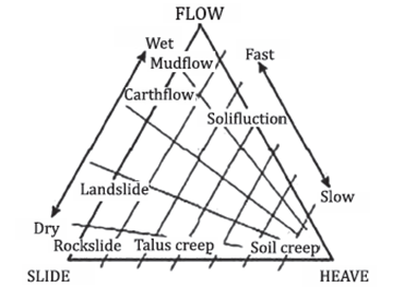
- Slow Mass Movement: Movements that occur over a period of time, such as soil creep, where materials slowly move down a slope.
- Rapid Mass Movement: These occur suddenly and can be highly destructive, including landslides, mudflows, and rockfalls.
- Landslide: A specific type of rapid mass movement where a section of the slope gives way and slides down.
5. Causes of Mass Movements
- Slope Failure: This is often due to a combination of natural and human-induced factors that destabilize the slope, leading to a sudden collapse.
- Sediment Flows: These involve the flow of debris mixed with water or air. They can be triggered by heavy rainfall, rapid snowmelt, or volcanic activity.
The processes of mass movement
The processes of mass movement are categorized based on the speed of movement, the type of materials involved, and the mechanisms by which these materials are moved down slopes. These processes range from very slow movements, barely perceptible over short time frames, to rapid and catastrophic events that can cause significant alteration to the landscape and pose serious risks to human life and property.
Slow Mass Movement
1.Soil Creep
- Soil creep refers to the very slow and gradual movement of soil or rock particles downhill. It is often imperceptible except over long periods. The evidence of soil creep includes bent trees, inclined utility poles, and fences that appear to move or tilt over time. This movement is caused by a variety of factors, including the expansion and contraction of material due to freezing and thawing, wetting and drying, and the impact of gravity on loosened materials.
2.Solifluction
- Solifluction is a specific type of creep that occurs in saturated soil conditions. It is most common in areas with permafrost, where the active layer above the permafrost thaws and becomes saturated with water, making it flow very slowly over the impermeable frozen ground beneath. Solifluction creates lobate or tongue-shaped features on the landscape and is a significant geomorphic process in cold environments.
Rapid Mass Movement (Only Top Soil Flows)
1. Earth Flow
- Earth flows occur when the water saturation of soil or debris on a slope increases, usually due to heavy rainfall, leading to a downward movement of material. The flow can vary in speed but is generally faster than creep and solifluction. Earth flows can cause significant alteration to the landscape and pose risks to structures and lives.
2. Mud Flow
- Mud flows are rapid flows of soil and debris that have become saturated with water. They can move at high speeds and have the consistency of wet concrete or soup. Volcanic mudflows, or lahars, are a specific type of mud flow associated with volcanic activity, where volcanic ash and debris become saturated with water and flow down slopes at high speeds.
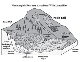
3. Debris Avalanche
- A debris avalanche is a very rapid flow of a large volume of debris and soil that occurs when a slope collapses. These can travel long distances and occur with little warning, making them particularly dangerous. Debris avalanches are often triggered by factors such as heavy rainfall, earthquakes, or volcanic activity.
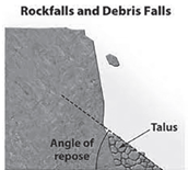
- Rock Fall: The free fall of rocks from a steep slope or cliff. This occurs when individual rocks or boulders become detached and fall, often bouncing or rolling down the slope.
- Debris Fall: Similar to rock falls but involves a mixture of rocks, soil, vegetation, and other materials.
- Slump: A type of landslide where the material moves downward and outward, leaving behind a crescent-shaped scar. The material often rotates as it slides, causing the upper surface to remain relatively undisturbed.
- Translational Slides: These occur when a mass of soil or rock moves down a slope along a relatively planar surface without rotation. This can happen along weaknesses in the rock or soil, such as bedding planes, joint systems, or the interface between different materials.
Erosion and Transportation
Erosion and transportation are fundamental geomorphic processes that reshape the Earth’s surface. These processes involve the breakdown, removal, and movement of soil and rock materials by various natural agents.
Erosion
Erosion is the process through which earth materials are acquired and transported. This action is primarily facilitated by geomorphic agents such as wind, water, groundwater, glaciers, and waves. Erosion plays a crucial role in shaping the Earth’s surface by wearing away rocks and soils. The main types or processes of erosion include:
1. Abrasion (Corrasion)
-
- Definition: The mechanical scraping of a rock surface by friction between rocks and moving particles during their transport by wind, glacier, waves, gravity, or running water.
- Types:
- Vertical Corrasion: Acts downward, deepening the valley or stream bed.
- Lateral Corrasion: Acts on the lateral sides of valleys or streams, widening them.
2. Attrition
- Definition: The process where rock or material collides with each other when transported, breaking them down into smaller pieces.
3. Corrosion (Solution Erosion)
- Definition: The chemical dissolution of soluble rocks by water. It involves the chemical or solvent action of water on soluble or partly soluble rocks, leading to their gradual dissolution.
4. Hydraulic Action
- Definition: Erosion that occurs as the motion of water dislodges, dissolves, or removes surface material.
5. Plucking
- Definition: Associated primarily with glacial erosion, where glaciers freeze to the underlying rock, then move, plucking pieces of rock away.
6. Deflation
-
- Definition: The removal of loose, fine-grained particles by the turbulent action of the wind.
Transportation
The transportation of eroded material is an integral part of the erosion process, enabling the movement of sediments from their origin to new locations. This is accomplished through various methods:
1. Traction
- Definition: Heavier and larger rock fragments are rolled along the bed of a river by the flow of water. This load is known as the traction load.
2. Saltation
- Definition: A process where particles move in a series of jumps or bounces along the stream bed, primarily for medium-sized particles.
3. Suspension
- Definition: Smaller particles, such as sand, silt, and mud, are carried within the flow of the water, never touching the streambed.
4. Solution
-
- Definition: Dissolved materials are transported within the water. This process typically involves soluble materials such as calcium carbonate.
Weathering Vs Erosion Vs Mass movement
Weathering, erosion, and mass movement are three distinct yet interrelated processes that play crucial roles in shaping the Earth’s surface.
1. Weathering
Weathering is the process that involves the physical disintegration and chemical alteration of rocks and minerals at or near the Earth’s surface. This process does not involve the movement of weathered materials from their original location. Weathering can be classified into two main types:
- Physical Weathering (Mechanical Weathering): This involves the breaking down of rocks into smaller pieces without changing the chemical composition of the material. Common mechanisms include frost action, thermal expansion and contraction, and salt crystal growth.
- Chemical Weathering: This involves the alteration of the chemical composition of rocks and minerals due to reactions with water, oxygen, carbon dioxide, and other substances. It can result in the formation of new minerals and the dissolution of others. Common processes include hydrolysis, oxidation, and carbonation.
2. Erosion
Erosion is the process of removing particles from their original site through natural agents such as water, wind, ice, and gravity. Unlike weathering, erosion involves the movement of weathered materials. Erosion can lead to significant changes in the landscape over time and is a key process in the formation of various landforms. The main agents of erosion include:
- Water: Streams and rivers can carry particles downstream, while ocean waves can erode coastal areas.
- Wind: Wind can transport fine particles over long distances, particularly in arid regions.
- Ice: Glaciers can pick up and transport a wide range of material sizes as they move.
- Gravity: Gravity can cause rocks and soil to move downhill, sometimes as part of mass movement processes.
3. Mass Movement
Mass Movement (Mass Wasting) refers to the downhill movement of rock and soil under the direct influence of gravity. This process does not require a transporting medium like water, wind, or ice. Instead, gravity itself is sufficient to cause movement. Mass movement can occur suddenly, as in the case of rockfalls and landslides, or slowly, as with soil creep. Factors contributing to mass movement include the slope angle, water content, vegetation cover, and the type of earth materials.
| Aspect | Weathering | Erosion | Mass Movement |
| Definition | Physical disintegration or chemical alteration of rocks at or near the Earth’s surface. | Physical removal and transportation of weathered material by agents like water, wind, ice, or gravity. | Transfer or movement of rock or soil down slope primarily by gravity. |
| Mechanism | Physical (mechanical) weathering
Chemical weathering |
Water
Wind Ice Gravity |
Gravity |
| Movement | No movement from the original location. | Movement away from the original location. | Movement down slope. |
| Agents | Temperature changes, water, carbon dioxide. | Water, wind, ice, and gravity. | Gravity. |
| Processes | Frost wedging, thermal expansion, hydrolysis, oxidation. | Fluvial (by rivers), aeolian (by wind), glacial, coastal. | Rockfalls, landslides, soil creep, mudflows. |
| Impact on Landscape | Prepares material for erosion. | Transports and deposits materials, shaping landscapes. | Causes sudden or gradual changes in landscape relief and slope stability. |
Understanding the distinctions and interconnections among weathering, erosion, and mass movement is crucial for comprehending the dynamic processes that shape the Earth’s surface over time.
UPSC PREVIOUS YEAR QUESTIONS
1. Which of the following statements regarding laterite soils of India are correct? (2013)
1.They are generally red in colour.
2.They are rich in nitrogen and potash.
3.They are well-developed in Rajasthan and UP.
4.Tapioca and cashew nuts grow well on these soils.
Select the correct answer using the codes given below:
(a) 1, 2 and 3
(b) 2, 3 and 4
(c) 1 and 4
(d) 2 and 3 only
2. Consider the following: (2013)
1.Electromagnetic radiation
2.Geothermal energy
3.Gravitational force
4.Plate movements
5.Rotation of the earth
6.Revolution of the earth
Which of the above are responsible for bringing dynamic changes on the surface of the earth?
(a) 1, 2, 3 and 4 only
(b) 1, 3, 5 and 6 only
(c) 2, 4, 5 and 6 only
(d) 1, 2, 3, 4, 5 and 6
3. Which of the following phenomena might have influenced the evolution of organisms? (2014)
1. Continental drift
2. Glacial cycles
Select the correct answer using the code given below.
(a) 1 only
(b) 2 only
(c) Both 1 and 2
(d) Neither 1 nor 2
4. The black cotton soil of India has been formed due to the weathering of: (2021)
(a) brown forest soil
(b) fissure volcanic rock
(c) granite and schist
(d) shale and limestone
5. In India, the problem of soil erosion is associated with which of the following? (2014)
1.Terrace cultivation
2.Deforestation
3.Tropical climate
Select the correct answer using the code given below.
(a) 1 and 2 only
(b) 2 only
(c) 1 and 3 only
(d) 1, 2 and 3

