EVOLUTIONARY HISTORY & STRUCTURE OF THE EARTH
Introduction
- The geological history of the Earth is a complex and fascinating subject that encompasses the transformation of our planet from a barren, rocky, and hot object into the life-supporting world we know today. This history is marked by significant geological and atmospheric changes that have occurred over billions of years.
Initial Formation and Conditions
- Barren and Rocky Beginnings: The Earth formed approximately 4.6 billion years ago from the solar nebula, a giant, rotating cloud of gas and dust left over from the Sun’s formation. Initially, the Earth was a molten mass due to the heat generated from the gravitational energy of material accreting onto it, as well as the decay of radioactive elements.
- Hot Object with a Thin Atmosphere: As the Earth started to cool, its surface solidified. However, it remained extremely hot, and its thin atmosphere was composed primarily of hydrogen and helium. This early atmosphere was not conducive to life as we know it, lacking water vapor, oxygen, and other gases necessary for biological processes.
Earth’s Layered Structure
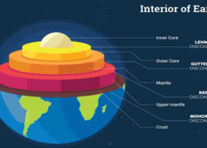
- Layered Structure Development: As the Earth continued to cool and differentiate, it developed a layered structure. This stratification is based on density and material composition, extending from the outermost atmospheric layer to the dense inner core.
- The Crust: The Earth’s outermost solid layer is the crust, composed of low-density silicate minerals. It is divided into two types: the continental crust, which is thicker and less dense, and the oceanic crust, which is thinner and denser.
- The Mantle: Beneath the crust lies the mantle, a thick layer of silicate rocks that are denser and higher in magnesium and iron. The mantle is divided into the upper and lower mantle, where varying pressure and temperature conditions affect rock behavior and chemical composition.
- The Core: At the center of the Earth is the core, which is further divided into the liquid outer core and the solid inner core. The outer core is composed of molten iron and nickel, while the inner core is solid due to the immense pressures that exceed the melting point of its iron-nickel alloy.
Evolution of the Atmosphere and Conditions for Life
- Transformation of the Atmosphere: Over time, volcanic outgassing released water vapor, carbon dioxide, nitrogen, and other gases into the atmosphere, gradually transforming it into a more complex and life-supporting envelope. The development of photosynthetic organisms eventually led to the production of oxygen, radically changing the atmosphere’s composition and paving the way for aerobic life forms.
- Development of Life: The stabilization of Earth’s climate, along with the presence of liquid water and a suitable atmosphere, created the conditions necessary for the emergence of life. The earliest known life forms appeared around 3.5 billion years ago, with complex life evolving in the oceans and later colonizing land surfaces.
- The geological history of the Earth is a testament to the dynamic processes that have shaped our planet. From a hostile, molten sphere to a diverse ecosystem teeming with life, the Earth’s transformation is a continuous process, influenced by its internal dynamics, surface processes, and external factors like solar radiation and cosmic events. This ongoing evolution reflects the intricate interplay between the geosphere, atmosphere, hydrosphere, and biosphere, highlighting the Earth’s uniqueness in the cosmos.
Indirect Methods
Indirect methods for estimating the age of the Earth rely on observations and measurements of processes that, over long periods, can provide clues about the planet’s history.
Sedimentation Clock
- The sedimentation clock method estimates the Earth’s age by analyzing the average annual rate of sedimentation and the total thickness of sedimentary strata. Sediments accumulate in layers over time, and by measuring the thickness of these layers and estimating the rate at which they have been deposited, scientists can infer the duration of sediment accumulation.
- This method involves drilling into Earth’s crust to extract core samples of sediment layers. By examining the composition, thickness, and order of these layers, geologists can reconstruct the sequence of geological events and estimate the time required for the deposition of the strata.
Salinity Clock
- The salinity clock method estimates the Earth’s age by measuring the accumulation of sodium and other salts in the oceans. The theory posits that since Earth’s oceans were formed, salts have been steadily accumulating through processes such as volcanic activity and weathering of rocks.
- This method has provided much earlier estimates of Earth’s age, around 100 million years ago, which are significantly lower than current estimates based on more accurate radioactive dating methods.
Evolutionary Change in Animals
- Fossil records provide evidence of the evolutionary changes in animals over geological time. By studying fossils, scientists can trace the development of life on Earth and estimate the time periods during which various forms of life have existed.
- Based on the fossil record, this method has suggested an age of around 1000 million years for the Earth. However, this approach only dates back to the earliest known life forms and not the formation of the Earth itself.
Rate of Cooling of Earth
- Lord Kelvin proposed an estimate of the Earth’s age based on its rate of cooling. He assumed the Earth started as a molten mass and calculated how long it would take to cool to its current temperature.
- Kelvin’s calculations suggested an age of about 100 million years. However, this method did not account for heat produced by radioactive decay, leading to an underestimation of the Earth’s age.
Varved Sediments
- Varved sediments are layers of sedimentary rock that display distinct annual layers or “varves,” typically formed in glacial environments. Each pair of layers, usually consisting of a lighter summer layer and a darker winter layer, represents one year.
- By counting these layers, scientists can determine the number of years represented by a section of varved sediment, providing a direct record of time.
Radioactive Methods
- Radioactive dating methods have revolutionized our understanding of the Earth’s age by providing a direct means of dating rocks and minerals based on the decay of radioactive isotopes.
Radioactive Decay
- This method is based on the principle that unstable isotopes (“parent”) decay into stable isotopes (“daughter”) at a constant rate, known as the half-life—the time required for half of the original radioactive material to decay.
- The ratio of parent to daughter isotopes in a sample can be measured, allowing scientists to calculate the age of the sample based on known half-lives.
Common Radioactive Dating Methods
- Uranium-Lead Method: Used to date rocks older than 1 million years.
- Thorium-Lead Method: Similar to the uranium-lead method, used for dating ancient rocks.
- Potassium-Argon Method: Used for dating volcanic rocks.
- Radiocarbon Method: Used to date organic materials up to about 60,000 years old.
Estimation of Earth’s Age
- Current Understanding: The radioactive dating methods, especially the uranium-lead method, have provided a consistent estimate of the Earth’s age at about 4.5 billion years. This age is supported by dating meteorites and lunar rocks, which are believed to have formed at the same time as the Earth.
Geological Time Scale
The Geological Time Scale (GTS) is a system of chronological measurement that relates stratigraphy to time, used by geologists, paleontologists, and other Earth scientists to describe the timing and relationships of events in the geologic history of Earth.
| Eon | Era | Period | Epoch | Years Before Present | Major Events |
| Holocene | 0 – 10,000 | Modern man; Sixth mass extinction | |||
| Quaternary | Pleistocene | 10,000 – 2 million | Homo sapiens; ice age | ||
| Pliocene | 2 – 5 million | Early human ancestor; great Indian North Plains | |||
| Miocene | 5 – 24 million | Ape, flowering plants and trees | |||
| Cenozoic | Tertiary | Oligocene | 24 – 37 million | Anthropoid ape | |
| Eocene | 37 – 58 million | Rabbits & Hare | |||
| Phanerozoic | Paleocene | 57 – 65 million | Small mammals – rats & mice | ||
| Cretaceous | 65 – 144 million | Extinction of Dinosaurs; first true bird evolved; Fifth mass extinction | |||
| Mesozoic | Jurassic | 144 – 208 million | Age of Dinosaurs | ||
| Triassic | 208 – 245 million | Frogs & turtles; fourth mass extinction | |||
| Permian | 245 – 286 Million | Reptile dominate-replace amphibians; the great dying or third mass extinction. | |||
| Palaeozoic | Carboniferous | 286 – 360 Million | First Reptiles: Vertebrates: Coal beds | ||
| Devonian | 360 – 408 Million | Amphibians; second mass extinction. | |||
| Silurian | 408 – 438 Million | First trace of life on land: Plants. | |||
| Ordovician | 438 – 505 Million | First mass extinction. | |||
| Cambrian | 505 – 570 Million | First Fish; Cambrian explosion. No terrestrial Life: Marine Invertebrate | |||
| Proterozoic | 570 – 2,500 Million | Snowball Earth period | |||
| Archean | 2,500 – 3,800 Million | Blue green Algae: Unicellular prokaryotic bacteria | |||
| Hadean | 3,800 – 4,800 Million | Oceans and Continents form – Ocean and Atmosphere are rich in Carbon dioxide; volcanic outgassing | |||
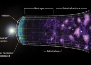
| Before Eons | 5,000 – 13,700 Million | Origin of stars (5,000 Million); Supernova (12,000 Million); Big Bang – Origin of the universe (13,700 Million) |
The evolution of Earth has been marked by significant climatic and environmental changes, which have had profound impacts on the planet’s geology, atmosphere, and the life forms residing on it.
Snowball Earth Period
- Definition: The Snowball Earth hypothesis refers to periods in Earth’s history when the entire planet’s surface was possibly covered by ice and snow. The most notable Snowball Earth periods occurred during the Proterozoic Eon, particularly in the Cryogenian Period, between 720 and 635 million years ago (MYA).
- Impact: This global glaciation led to a significant drop in sea levels due to the vast amount of water trapped in ice sheets. The extreme cold and the reduction in available habitats could have been a driving force for evolutionary changes in early life forms.
The Permian-Triassic Extinction Event
- Definition: This extinction event, which occurred approximately 252 MYA, is the most catastrophic in Earth’s history. It is also known as “The Great Dying.”
- Impact: It resulted in the extinction of up to 96% of all marine species and 70% of terrestrial vertebrate species. This event is unique because it is the only known mass extinction that affected insects significantly. The causes of this extinction are still debated, with theories including massive volcanic eruptions, methane release, and asteroid impacts contributing to a “deadly cocktail” of global warming, ocean acidification, and anoxia.
Ice Age
- Definition: An ice age is a prolonged period of cooling of Earth’s climate, leading to an expansion of the continental and polar ice sheets and glaciers.
- Impact: These periods are characterized by a significant drop in global temperatures and have been pivotal in shaping Earth’s current landscape, driving evolutionary processes, and affecting the distribution of life forms.
Glacial and Interglacial Periods
- Glacial Periods: These are cooler phases within an ice age where ice sheets and glaciers advance due to lower temperatures.
- Interglacial Periods: These are warmer intervals within an ice age when ice sheets and glaciers retreat, and global temperatures rise.
- Impact: The alternation between glacial and interglacial periods has influenced sea levels, climate patterns, and the distribution and evolution of flora and fauna across the globe.
Quaternary Glaciation
- Definition: This is the current and most recent of Earth’s ice ages, characterized by alternating glacial and interglacial periods. It started about 2.58 million years ago, during the Quaternary Period.
- Current Status: We are currently in an interglacial period known as the Holocene Epoch, which began approximately 11,700 years ago.
- Impact: The Quaternary glaciation has been a crucial period for human evolution and the development of civilizations, as it has shaped the environments in which early humans evolved and later societies developed agriculture and settled life.
- These terminologies and the events they describe are fundamental to understanding Earth’s climatic history and its impact on the development of life and landscapes on our planet. Each event has contributed to the dynamic and ever-changing nature of Earth, influencing the course of evolution and the diversity of life forms.
- The origin of life on Earth is a complex and fascinating process that intertwines with the evolution of the planet itself. This topic has intrigued scientists and scholars for centuries, and modern scientific theories have provided a framework for understanding how life began from inanimate matter.
Evolution of Earth and Its Relation to Life
The Earth formed about 4.5 billion years ago from the solar nebula, a cloud of gas and dust left over from the sun’s formation. The early Earth was a volatile environment, undergoing constant changes including volcanic eruptions, meteorite impacts, and shifting climates. These dynamic conditions were crucial for the formation of complex molecules necessary for life.
The Chemical Foundations of Life
Modern scientists propose that the origin of life was a result of chemical evolution, a series of chemical reactions leading to the formation of complex organic molecules from simpler inorganic compounds. This process likely occurred in Earth’s early oceans, where a “primordial soup” of molecules was subjected to energy sources such as lightning, ultraviolet radiation, and geothermal heat, facilitating the synthesis of organic compounds.
Key Stages in Chemical Evolution:
- Synthesis of Basic Organic Molecules: Simple organic molecules, such as amino acids and nucleotides, formed from inorganic substances. Experiments like the famous Miller-Urey experiment in 1953 have demonstrated that such molecules can arise under conditions simulating the early Earth’s atmosphere.
- Formation of Complex Organic Molecules: These simple molecules underwent further reactions, forming more complex molecules such as proteins and nucleic acids. This step is critical because these molecules are the building blocks of life, capable of performing essential biological functions.
- Self-Assembly and Duplication: A critical transition from non-living to living matter occurred when these molecules assembled in a manner that allowed them to replicate or duplicate themselves. This self-replicating system is considered a fundamental characteristic of life. It is hypothesized that RNA molecules might have been among the first self-replicating entities, given their ability to store genetic information and catalyze chemical reactions.
- Formation of Protocells: The next significant step was the formation of protocells, which are simple, cell-like structures that could maintain an internal chemical environment distinct from their surroundings. These structures were precursors to true cells, capable of metabolism and growth, and eventually, evolution into more complex life forms.
Emergence of Life
- Life is thought to have emerged around 3.8 to 3.5 billion years ago. The earliest forms of life were microscopic organisms, similar to present-day bacteria and archaea. Evidence of early life comes from fossilized stromatolites, structures formed by the layered growth of microbial communities, found in rocks dating back to about 3.5 billion years ago.
Evolution from Microscopic Structures to Complex Life
- The first life forms were simple, single-celled organisms, but over billions of years, they evolved into more complex multicellular organisms. This evolutionary process was gradual and influenced by numerous factors, including genetic mutations, natural selection, and changing environmental conditions.
- One of the earliest and simplest forms of life, resembling modern blue-green algae (cyanobacteria), appeared around 3,000 million years ago. Cyanobacteria were among the first organisms to perform photosynthesis, releasing oxygen into the atmosphere and dramatically altering Earth’s environment, eventually allowing for the evolution of oxygen-dependent life forms.
- The origin of life on Earth is a testament to the complexity and resilience of biological systems. From simple chemical reactions to the vast diversity of life observed today, the journey of life’s evolution is a profound chapter in the history of our planet. Understanding this process not only sheds light on our origins but also provides insights into the possibility of life beyond Earth, guiding future explorations into the unknown realms of the universe.
Evolution of The Atmosphere
The evolution of Earth’s atmosphere from its primordial state to its current composition is a complex process that unfolded over billions of years. This process can be delineated into three main stages, each characterized by significant changes in atmospheric composition and influenced by various geological and solar phenomena.
1. Loss of Primordial Atmosphere
Initial State:
- The Earth’s first atmosphere was formed shortly after its creation about 4.6 billion years ago.
- This atmosphere was primarily composed of hydrogen and helium, the most abundant elements in the universe, captured from the solar nebula.
Loss Due to Solar Winds:
- The early solar system was a turbulent place, with the young Sun emitting powerful solar winds.
- Earth’s gravitational pull was insufficient to retain these light gases, especially given the high energy particles from the solar wind.
- As a result, the primordial atmosphere was stripped away into space, leaving the Earth without a significant atmosphere.
2. Formation of the Early Atmosphere through Degassing
Outgassing Process:
- Following the loss of the initial atmosphere, Earth’s surface cooled, and a solid crust formed.
- The cooling of Earth’s interior led to the release of gases and water vapor through volcanic activity, a process known as degassing.
- This process contributed to the formation of a new atmosphere, mainly composed of water vapor (H₂O), carbon dioxide (CO₂), nitrogen (N₂), methane (CH₄), and ammonia (NH₃).
Significance of Water Vapor:
- The released water vapor played a crucial role in cooling the planet further, eventually condensing to form oceans.
- This early atmosphere lacked free oxygen (O₂) and was reducing in nature, meaning it could add electrons to other substances.
3. Evolution to the Present Atmosphere
Role of Volcanic Activity:
- Continuous volcanic eruptions over millions of years contributed significantly to the atmospheric composition by releasing more gases and water vapor.
- These eruptions helped to increase the levels of nitrogen and introduce more carbon dioxide and water vapor into the atmosphere.
Appearance of Oxygen:
- The great oxygenation event occurred around 2.4 billion years ago when photosynthetic organisms, like cyanobacteria, began to produce oxygen through photosynthesis.
- As oxygen levels increased, it led to the formation of the ozone layer, which protected the Earth from harmful solar radiation, making it possible for more complex life forms to develop.
Nitrogen Accumulation:
- Nitrogen accumulated in the atmosphere both from the degassing process and from the breakdown of ammonia by ultraviolet light and electrical discharges in the atmosphere.
- The relatively inert nature of nitrogen allowed it to accumulate over time, becoming the most abundant gas in the atmosphere.
Reduction of Greenhouse Gases:
- The carbon dioxide levels decreased over time due to the weathering of rocks and the formation of carbonate sediments, as well as being locked up in fossil fuels.
- This reduction in greenhouse gases, along with the increase in oxygen, gradually led to the atmosphere we recognize today, dominated by nitrogen (78%) and oxygen (21%), with trace amounts of other gases including argon, carbon dioxide, and water vapor.
- The transformation from a hydrogen and helium-rich primordial atmosphere to the nitrogen and oxygen-rich atmosphere of today was a gradual process influenced by the Earth’s geological activity, the sun’s activity, and the emergence of life, especially photosynthetic organisms. This evolutionary journey has made Earth uniquely suited for life as we know it.
Evolution of Lithosphere
The evolution of the lithosphere is a fundamental aspect of Earth’s geological history, reflecting the dynamic processes that have shaped the planet’s surface and its tectonic activities. The lithosphere is the outermost layer of the Earth, encompassing the crust and the uppermost part of the mantle. It plays a crucial role in the movement of tectonic plates, volcanic activity, and the formation of geological features.
Definition and Composition
- Lithosphere Defined: The lithosphere is the rigid, outermost shell of the Earth. It is composed of the crust and the upper part of the mantle that behaves as a mechanical layer. Unlike the asthenosphere below it, which is partially molten and can flow, the lithosphere remains solid due to its lower temperature and higher strength.
- Composition and Structure: The lithosphere’s composition varies from the silica-rich rocks of the continental crust to the more iron and magnesium-rich rocks of the oceanic crust and the upper mantle. This variation in composition contributes to the differences in density and thickness between the continental and oceanic lithosphere.
Evolutionary Processes
The evolution of the lithosphere is driven by the heat from the Earth’s interior, which causes thermal convection in the mantle. This convection is a critical force in plate tectonics, leading to the formation, movement, and interaction of lithospheric plates.
- Formation of the Lithosphere: The lithosphere began to form soon after the Earth’s solidification, over 4 billion years ago. As the Earth cooled, solidification of the crust occurred, and the upper mantle became rigid, giving rise to the lithosphere.
- Differentiation of Layers: The process of differentiation, driven by the heat from the Earth’s interior, caused materials with different densities to segregate, forming distinct layers. This resulted in the lithosphere having a lower density compared to the underlying mantle, allowing it to “float” atop the more ductile asthenosphere.
- Plate Tectonics: The movement and interactions of lithospheric plates are central to understanding the lithosphere’s evolution. These plates can diverge, converge, or slide past each other, leading to the formation of mountains, oceanic trenches, and volcanic activity. The cycle of plate creation at divergent boundaries and consumption at convergent boundaries continuously reshapes the lithosphere.
Significance of the Lithosphere
- Surface Processes and Features: The lithosphere is directly involved in the formation of Earth’s topography, including mountains, valleys, and basins. Its structure and movements influence the distribution of landforms and bodies of water, shaping the planet’s surface.
- Geological Activity: The lithosphere is the site of significant geological activity, such as earthquakes, volcanoes, and mountain-building processes. These activities are primarily concentrated at plate boundaries, where the interactions between plates occur.
- Climate and Life: The evolution of the lithosphere has profound implications for climate and life on Earth. The configuration of continents and oceans affects atmospheric circulation patterns, ocean currents, and climate over geological timescales. Additionally, the recycling of carbon through subduction zones plays a role in the long-term carbon cycle, influencing global climate.
Evolution of The Hydrosphere
The evolution of the hydrosphere, encompassing all of Earth’s water bodies including oceans, seas, rivers, lakes, and underground water, is a fundamental aspect of our planet’s history. This process began early in Earth’s formation and has played a crucial role in shaping the environment, influencing climate, and enabling the development of life.
Formation of Earth’s Hydrosphere
Initial Stages
- Condensation of Water Vapors: The primary mechanism for the formation of the hydrosphere was the condensation of water vapor in the Earth’s early atmosphere. This water vapor was largely released through the process of degassing, a phase during which volatile substances, including water vapor, were expelled from the Earth’s interior to the surface and atmosphere.
- Degassing Process: Degassing occurred through volcanic eruptions and the continual venting of gases from the planet’s mantle. As the Earth cooled following its formation, these gases, which included significant amounts of water vapor along with carbon dioxide, methane, ammonia, and other volatile compounds, were released into the atmosphere.
Formation of Oceans
- Cooling of Earth’s Surface: The cooling of Earth’s surface was critical for the condensation of water vapor into liquid water. As the planet’s surface temperature decreased below the boiling point of water, condensation began, leading to the formation of water droplets and eventually rain.
- Accumulation of Water: Over millions of years, continuous rain fell onto the Earth’s surface, filling the depressions and lower areas to form the first oceans and water bodies. This process was greatly influenced by the Earth’s topography, which was continually reshaped by geological processes such as plate tectonics and volcanic activity.
- Completion within 500 Million Years: Remarkably, the Earth’s oceans were formed within 500 million years from the formation of the planet. This rapid accumulation of water bodies set the stage for the development of the Earth’s climate system and the emergence of life.
Further Evolution
After the initial formation of oceans, the hydrosphere continued to evolve in response to various geological and atmospheric processes:
- Water Cycle: The establishment of the water cycle, involving evaporation, condensation, precipitation, and runoff, became a crucial mechanism for distributing water across the planet, shaping climates, and influencing the chemical composition of the oceans.
- Interactions with Other Spheres: The hydrosphere interacts dynamically with the atmosphere, lithosphere (Earth’s crust and upper mantle), and biosphere (the realm of all living organisms). These interactions have led to significant changes in the hydrosphere over geological timescales, including variations in ocean salinity, the formation of ice ages, and the development of life in aquatic environments.
- Role in Earth’s Climate: The hydrosphere plays a key role in regulating the Earth’s climate. Oceans act as a major heat reservoir, absorbing and distributing solar energy, which influences global climate patterns and weather phenomena.
- The evolution of the hydrosphere from the condensation of water vapors to the formation of Earth’s vast and life-sustaining oceans is a testament to the dynamic processes that have shaped our planet. Within the first 500 million years of Earth’s history, the foundation was laid for the development of complex ecosystems and the emergence of life. This early establishment and ongoing evolution of the hydrosphere have been crucial for maintaining the conditions necessary for life as we know it.
The Earth
The Earth is a complex and dynamic planet, serving as the home to countless species of life, including humans. Its unique characteristics have been a subject of fascination and study for centuries, leading to discoveries that have shaped our understanding of the planet and its place in the solar system.
The “Blue Planet”
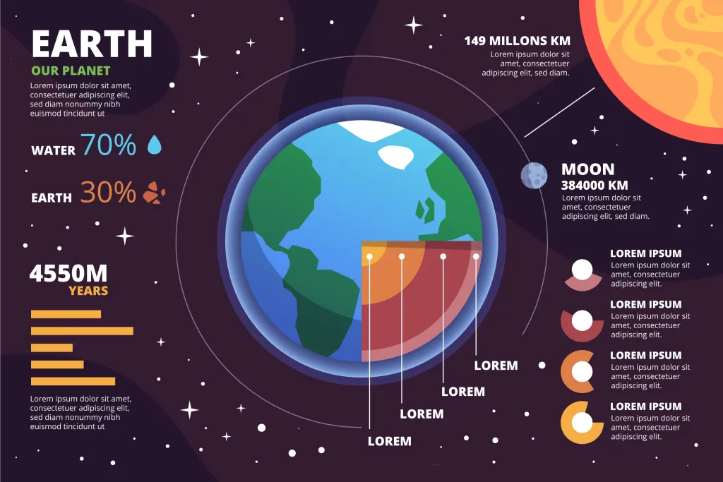
- Water Coverage: Earth is often referred to as the “Blue Planet” due to its appearance from space. Approximately two-thirds (about 71%) of Earth’s surface is covered by water, predominantly the oceans. This vast coverage of water is crucial for Earth’s climate and for supporting life.
Distance from the Sun
- Orbital Characteristics: Earth is located an average distance of about 149 million kilometers (92.96 million miles) from the Sun. This distance places Earth within the Sun’s habitable zone, where temperatures allow for liquid water to exist – a critical factor for life as we know it.
Shape of the Earth
- Geoid and Oblate Spheroid: While the Earth is often simplified as a sphere in many diagrams, its true shape is more accurately described as an oblate spheroid. This means the planet is slightly flattened at the poles and bulged at the equator due to its rotation. The term “geoid” is used to describe Earth’s shape as influenced by its gravitational field and rotation, making it an irregular shape rather than a perfect sphere.
Dimensions
- Equatorial vs. Polar Diameter: The diameter of Earth at the equator is about 12,756 kilometers (7,926 miles), compared to a slightly smaller diameter of 12,713.6 kilometers (7,900 miles) at the poles. This difference is a direct result of the planet’s rotation, which causes the equatorial bulge.
Rotation Speed
- Variation with Latitude: Earth’s rotation speed varies with latitude. At the equator, the speed of rotation is approximately 1,600 kilometers per hour (994 miles per hour). This speed decreases as one moves poleward, due to the decreasing circumference of the Earth at higher latitudes. This variation in rotation speed has several implications, including differences in day length and the effect on atmospheric and oceanic circulation patterns.
Implications of Earth’s Characteristics
- Climate and Life: The distribution of water, Earth’s distance from the Sun, its shape, and rotational dynamics all play critical roles in determining the planet’s climate patterns, weather systems, and the ability to support a diverse range of life forms.
- Geographical Diversity: These characteristics also contribute to Earth’s geographical diversity, influencing the formation of various landforms, ocean currents, and ecosystems.
- Human Perception and Activities: The variation in rotation speed and the shape of the Earth affect human activities in subtle ways, from navigation and satellite operations to understanding time zones and managing global communication networks.
Latitudes
Latitudes are a fundamental component of the Earth’s geographical coordinate system, which also includes longitudes. Together, these imaginary lines form a grid that helps us pinpoint exact locations on the planet.
Definition and Function
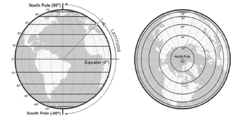
- Latitudes are horizontal lines that encircle the Earth, parallel to the equator. They are used to measure the angular distance of a location north or south of the equator.
- Purpose: Latitudes serve as a reference system for navigation, mapping, and geographical analysis, allowing us to specify locations on Earth with precision.
Characteristics
- Parallel Lines: All latitude lines are parallel to each other, hence the term “parallels of latitude.”
- Concentric Circles: Viewed from the poles, latitudes appear as concentric circles, with the equator being the largest circle and the circles diminishing in size as they approach the poles.
- Measurement Units: Latitudes are measured in degrees (°), with each degree divided into 60 minutes (‘) and each minute into 60 seconds (“).
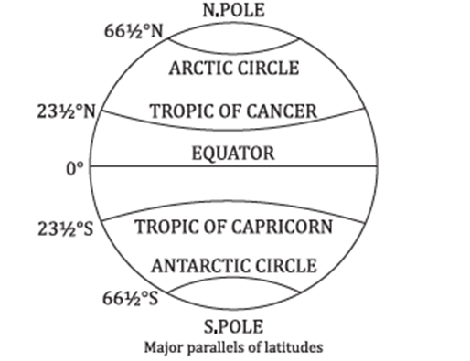
- Unequal Circumferences: The equator, at 0° latitude, is the largest circle, while the circles decrease in size toward the poles, which are at 90° North and South latitude, representing the smallest circles.
- Fixed Distance: The average distance between each degree of latitude is approximately 111 kilometers (about 69 miles), due to the spherical shape of the Earth.
Specifics
- Equator: The equator is the largest latitude circle, lying equidistant from the poles, and is designated as 0° latitude. It effectively divides the Earth into the Northern and Southern Hemispheres.
- Poles: The North and South Poles represent the shortest latitude circles, each located at 90° latitude from the equator.
- Total Latitudes: The Earth has a total of 181 latitudes, including the equator, 90 latitudes in the northern hemisphere, and 90 in the southern hemisphere.
- Circles of Latitude: These are imaginary rings that connect all points sharing the same parallel, making navigation and location mapping possible.
Importance in Geography and Navigation
- Climate Zones: Latitudes are crucial for defining climate zones on Earth. Regions near the equator experience warmer climates, while those near the poles are colder.
- Time Zones: Although primarily determined by longitude, latitudes play a role in the general understanding of global time zones, especially in their relation to the Earth’s rotation and orbit.
- Navigation: Latitudes, used in conjunction with longitudes, are essential for navigation, enabling sailors and pilots to traverse the globe accurately.
EQUATOR
The Equator is one of the most significant geographical lines that encircles the Earth, playing a vital role in our understanding of geography, climate, and the distribution of Earth’s ecosystems.
Definition and Geographical Significance
- Equator: The Equator is an imaginary line that lies equidistant from the North and South Poles, dividing the Earth into the Northern and Southern Hemispheres. It is defined as 0 degrees latitude.
- Perpendicular to Earth’s Axis: The Equator is perpendicular to the Earth’s axis of rotation, meaning it intersects the axis at a right angle. This orientation is crucial for the distribution of sunlight on Earth.
Equatorial Circle
- Creation: The Equatorial Circle is a conceptual circle formed by projecting the Equator outwards to the Earth’s surface. It represents the largest circumference of the Earth.
- Division of the Earth: By its definition, the Equator splits the Earth into two equal halves: the Northern Hemisphere and the Southern Hemisphere. This division is fundamental in understanding global climate patterns, seasons, and day length variations.
Latitude and Hemisphere
- Latitudes: Latitudes are imaginary lines parallel to the Equator used to determine the location of a place on Earth’s surface. They are measured in degrees north or south of the Equator.
- North and South Latitudes: Locations situated north of the Equator are in the Northern Hemisphere and are denoted with an “N” for North latitudes. Conversely, locations south of the Equator are in the Southern Hemisphere, denoted with an “S” for South latitudes.
- Size Variation: The size (or length) of latitudes decreases progressively from the Equator towards the poles, reflecting the spherical shape of the Earth.
Equinoxes
- Equinox: An equinox is an astronomical event that occurs twice a year, when the Sun is positioned directly above the Equator. This results in nearly equal day and night durations across the globe.
- Vernal (Spring) Equinox (21st March): This marks the beginning of spring in the Northern Hemisphere and autumn in the Southern Hemisphere. It signifies a time of balance and renewal.
- Autumnal Equinox (22nd September): This equinox signals the onset of autumn in the Northern Hemisphere and spring in the Southern Hemisphere, indicating a transition in the seasonal cycle.
Countries the Equator Passes Through
The Equator traverses various landmasses and waters, influencing the climates and ecosystems of the regions it crosses. Some countries located along the Equator:
- South America: Ecuador, Colombia, and Brazil experience diverse ecosystems, from dense rainforests to mountainous highlands, largely due to their equatorial location.
- Africa: The Equator passes through several African countries, including Sao Tome and Principe, Gabon, Congo, the Democratic Republic of Congo, Uganda, Kenya, and Somalia. These regions are characterized by tropical climates and rich biodiversity.
- Asia: In Asia, the Equator crosses the Maldives, Indonesia, and Kiribati, with Indonesia being particularly known for its extensive archipelago and unique wildlife.
- The Equator is more than just a geographical marker; it is a fundamental concept that affects Earth’s climate, day length, and biodiversity. Understanding the Equator and its impact on the planet helps us appreciate the diversity of environments and cultures that thrive along this imaginary line. The equatorial regions, with their unique climatic conditions, host some of the world’s most vital ecosystems, underscoring the importance of preserving these areas for future generations.
Tropical Circles
The concept of tropical circles plays a crucial role in understanding the Earth’s climatic zones and the distribution of solar radiation across the planet. The two tropical circles, the Tropic of Cancer and the Tropic of Capricorn, mark significant latitudinal positions that are key to the Earth’s solar dynamics.
Tropical Circles
Tropic of Cancer:
- Location:5° North of the Equator
- Significance: Marks the northernmost latitude at which the Sun can be directly overhead.
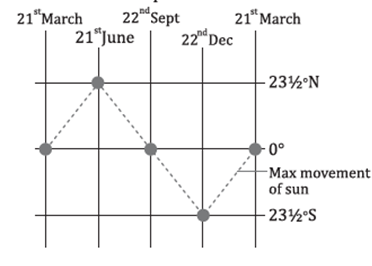
- Solar Event: During the Summer Solstice on June 21st, the Sun is directly overhead at noon at the Tropic of Cancer. This day marks the longest day of the year in the Northern Hemisphere.
Tropic of Capricorn:
- Location:5° South of the Equator
- Significance: Marks the southernmost latitude at which the Sun can be directly overhead.
- Solar Event: During the Winter Solstice on December 22nd, the Sun is directly overhead at noon at the Tropic of Capricorn. This day marks the longest day of the year in the Southern Hemisphere.
Importance of Tropical Circles
Solar Positioning:
- The tropical circles delineate the boundaries within which the Sun can appear directly overhead at some point during the year. This phenomenon contributes to the intense solar radiation received in the tropics, leading to warmer climates compared to regions beyond these circles.
Climatic Implications:
- The areas enclosed by the Tropic of Cancer in the north and the Tropic of Capricorn in the south are known as the tropics. This region experiences minimal seasonal variation in temperature but has varying rainfall patterns, leading to diverse ecosystems such as rainforests, savannas, and deserts.
No Shadow Day:
- On the days when the Sun is directly overhead at the Tropic of Cancer or the Tropic of Capricorn, objects at that latitude can experience a “no shadow day” at noon, because the Sun’s rays fall vertically.
Solstices and Their Significance
Summer Solstice (June 21st):
- Occurs when the Earth’s axial tilt toward the Sun is at its maximum in the Northern Hemisphere.
- The Sun is directly overhead at the Tropic of Cancer, resulting in the longest day of the year in the Northern Hemisphere.
- Regions within the Arctic Circle experience continuous daylight, known as the Midnight Sun.
Winter Solstice (December 22nd):
- Occurs when the Earth’s axial tilt away from the Sun is at its maximum in the Northern Hemisphere.
- The Sun is directly overhead at the Tropic of Capricorn, marking the longest day of the year in the Southern Hemisphere.
- Similar to the Summer Solstice in the north, the Antarctic Circle experiences continuous daylight during this time.
- The Tropic of Cancer and the Tropic of Capricorn are two significant latitudinal lines that mark the furthest north and south, respectively, at which the sun can appear directly overhead at noon. These lines are crucial in dividing the Earth into the tropical zone and the temperate zones. Additionally, the polar circles and the poles themselves have unique characteristics that contribute to Earth’s climatology and day-night patterns.
Tropic of Cancer
The Tropic of Cancer, situated at approximately 23.5° North latitude, passes through several countries across three continents, illustrating the global diversity it spans:
- North America: It crosses the Bahamas (an archipelago), and Mexico.
- Africa: It traverses Egypt, Libya, Niger, Algeria, Mali, Western Sahara, and Mauritania.
- Asia: It goes through Taiwan, China, Myanmar, Bangladesh, India, Oman, the United Arab Emirates, and Saudi Arabia.
- In India specifically, it passes through eight states: Gujarat, Rajasthan, Madhya Pradesh, Chhattisgarh, Jharkhand, West Bengal, Tripura, and Mizoram.
Tropic of Capricorn
Located at approximately 23.5° South latitude, the Tropic of Capricorn crosses continents and countries as follows:
- South America: It includes Argentina, Brazil, Chile, and Paraguay.
- Africa: It crosses Namibia, Botswana, South Africa, Mozambique, and Madagascar.
- Australia: It traverses the Australian continent, highlighting the country’s extensive range of latitudes.
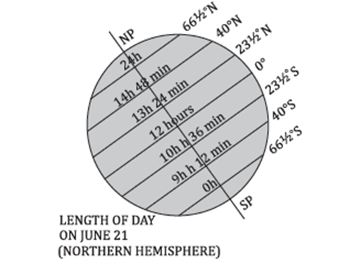
Polar Circles
The polar circles are located at approximately 66.5° north and south of the Equator and signify the limits beyond which, for at least one day a year, the sun does not set (during the summer solstice) or does not rise (during the winter solstice).
- Arctic Circle (66.5°N): In the Northern Hemisphere, the area inside this circle experiences 24 hours of daylight on June 22nd and 24 hours of night on December 22nd.
- Antarctic Circle (66.5°S): In the Southern Hemisphere, the reverse is true, with 24 hours of daylight on December 22nd and 24 hours of night on June 22nd.
North Pole and South Pole
- North Pole (90°N) and South Pole (90°S): These are the most northern and southern points on Earth, respectively. At these points, all lines of longitude converge.
- Day and Night Patterns: At the North Pole, the sun rises once a year in March and sets in September, marking a long day that lasts for six months. Conversely, during the other six months, it experiences a long night. This pattern is reversed at the South Pole.
- Equinoxes: During the equinoxes, the sun is at the horizon at the poles, leading to a unique phenomenon of 24-hour day or night, depending on the time of year.
- The Tropic of Cancer and the Tropic of Capricorn, along with the polar circles, illustrate the Earth’s tilt and orbit around the sun, affecting climate, daylight hours, and seasonal variations across different parts of the world. These geographical and celestial mechanics lead to a diverse range of environmental conditions, supporting a wide variety of life forms and ecosystems on Earth.
HEAT ZONES OF THE EARTH
The Earth is enveloped in a thermal blanket divided into three primary heat zones: the Torrid Zone, the Temperate Zones, and the Frigid Zones. These zones are determined by the Earth’s tilt in relation to the sun and its orbit, creating varied climates and living conditions across the planet. Each zone has unique characteristics with respect to sunlight exposure and temperature ranges.
Torrid Zone (Tropical Zone)
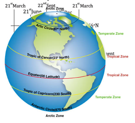
Geographical Range and Solar Exposure
- Location: The Torrid Zone encompasses the region between the Tropic of Cancer at 23.5°N latitude and the Tropic of Capricorn at 23.5°S latitude. It includes the equator, where the sun’s rays hit most directly.
- Sunlight: This zone receives the most intense sunlight throughout the year, as the sun is directly overhead at least once at every location within this zone on the days of the solstices.
- Daylight: The length of day and night remains relatively constant throughout the year, leading to small variations in daily temperature.
Climate and Ecological Characteristics
- Temperatures: Characterized by consistently high temperatures year-round, with minimal temperature variation between seasons.
- Precipitation: The zone includes areas with heavy rainfall, such as the tropical rainforests, as well as arid regions like deserts, where the dry air contributes to scarce precipitation.
- Biodiversity: The Torrid Zone boasts the highest biodiversity on Earth, including a vast array of flora and fauna adapted to its climate conditions.
Temperate Zones (Mid-Latitude Zones)
Geographical Range and Solar Exposure
- Location: Situated between the Tropic of Cancer and the Arctic Circle in the Northern Hemisphere, and between the Tropic of Capricorn and the Antarctic Circle in the Southern Hemisphere, encompassing latitudes from 23.5° to 66.5° in both hemispheres.
- Sunlight: These zones experience moderate sunlight with varying angles throughout the year, never receiving sunlight directly overhead but experiencing a higher sun angle in summer months.
- Daylight: There is a significant difference in day length across seasons, with long days in summer and short days in winter.
Climate and Ecological Characteristics
- Temperatures: Exhibits a wide range of temperatures with four distinct seasons – spring, summer, autumn, and winter.
- Precipitation: Varies greatly, with some areas experiencing consistent rainfall and others having distinct wet and dry seasons.
- Biodiversity: Supports a diverse mix of deciduous and coniferous forests, grasslands, and in some parts, Mediterranean vegetation.
Frigid Zones (Polar Zones)
Geographical Range and Solar Exposure
- Location: Found beyond the Arctic and Antarctic Circles, towards the poles, at latitudes higher than 66.5°.
- Sunlight: The sun is never directly overhead and remains low on the horizon throughout the year. During the polar winter, the sun does not rise, resulting in extended periods of darkness known as polar nights.
- Daylight: Experiences the phenomenon of the midnight sun during the summer months, where the sun remains visible for 24 hours a day.
Climate and Ecological Characteristics
- Temperatures: Persistently cold with the ground often permanently frozen, known as permafrost.
- Precipitation: Low, mostly in the form of snow, making these zones desert-like in terms of moisture.
- Biodiversity: Limited biodiversity with species adapted to extreme cold, such as polar bears in the Arctic and penguins in the Antarctic.
Longitude
Longitude is a fundamental concept in geographic coordinate systems, essential for navigation, timekeeping, and understanding the spatial layout of our planet.
Definition of Longitude
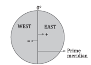
- Imaginary Lines: Longitudes, also known as meridians, are the imaginary lines that run vertically around the Earth, stretching from the North Pole to the South Pole.
- Angular Distance: Longitude is defined as the angular distance measured in degrees (°), east or west from the Prime Meridian.
- Prime Meridian as a Reference: The Prime Meridian, which is designated as 0° longitude, serves as the starting point for measuring longitude. It passes through the Royal Observatory in Greenwich, London, which is why it’s also known as the Greenwich Meridian.
Characteristics of Longitudes
- Meridians as Semi-Circles: Each meridian forms a semi-circle that spans from one pole to the other.
- Uniform Length: Unlike parallels of latitude, which vary in length, all meridians are of equal length since they span the same distance between the poles.
- Convergence at Poles: While the distance between two longitudes is widest at the equator, this distance decreases progressively towards the poles, where all the longitudes converge.
- Total Number of Meridians: There are 360 meridians that divide the Earth into segments. This division allows for a detailed and precise system for locating positions on the Earth’s surface.
Prime Meridian and Other Notable Meridians
- Prime Meridian (0° Longitude): As the central line of longitude, the Prime Meridian passes through several countries including the United Kingdom, France, Spain, Algeria, Mali, Burkina Faso, Ghana, and Togo.
- International Date Line (Approximately 180° Longitude): Roughly located on the opposite side of the Earth from the Prime Meridian, the International Date Line is significant for the change of calendar days.
Use and Importance of Longitudes
- Determining Local Time: Longitude is critical for determining local time. As the Earth rotates, each meridian experiences midday as the sun passes overhead. By establishing a system of time zones around different longitudes, we can maintain a standardized time system across the globe.
- Global Positioning System (GPS): Longitudes are used in conjunction with latitudes in GPS to pinpoint exact locations on the Earth.
- Navigation and Mapping: Longitudes allow sailors and pilots to navigate the globe and help cartographers to create accurate maps.
- Scientific Studies: Longitudinal data is important in studies of Earth’s rotation, the study of tectonics, and in the field of astronomy.
The concept of longitude is instrumental in joining points across the globe, creating an interconnected grid that facilitates global communication, travel, and the understanding of our world’s geography.
Local time and standard time are two critical concepts in understanding how time is measured and standardized across different regions of the world.
| Parameter | Local Time | Standard Time |
| Meaning | Local time refers to the time of a particular place determined by the apparent movement of the sun. This means that the time adjusts according to the position of the sun in the sky, which changes slightly as one moves east or west. | Standard time refers to a uniform time established for regions within the same time zone. This time is set by law in each country and does not change with the position of the sun. Instead, it is based on a standard longitudinal meridian (often in 15° increments) to facilitate synchronization of time within large areas. |
| Variations | Local time changes continuously as one moves from one longitude to another. This change is due to the Earth’s rotation, where every degree of longitudinal movement east or west results in a four-minute difference in solar time. | Standard time remains the same for all places within a particular time zone, regardless of the longitude. This means that even though the solar time might differ slightly within the zone, the standard time is kept uniform to simplify activities like travel, business, and communication. |
| Longitude | Places located on the same longitude share the same local time, as they experience the noon sun at the same moment. This is a direct result of their position relative to the sun’s apparent movement. | Places on the same longitude can have different standard times if they fall into different time zones. This division into time zones is a man-made construct designed to bring uniformity and convenience, often ignoring natural solar time for practical reasons. |
| Reckoned by | Local time is determined by the shadow cast by the sun. Traditionally, this was measured using sundials, where the sun’s position at noon (when the shadow is shortest) indicated local midday. | Standard time is reckoned by time zones, which are fixed according to chosen longitudinal meridians and do not change with the sun’s position. Each country or region aligns its standard time with a specific time zone, sometimes adjusting for daylight saving time. |
- Greenwich Mean Time (GMT): GMT is the mean solar time at the Prime Meridian (0° longitude), located at the Royal Greenwich Observatory in England. It serves as a reference point for determining time zones worldwide.
- East and West of Prime Meridian: Countries located east of the Prime Meridian add time (East – Gain – Add), while countries west subtract time (West – Lose – Subtract) relative to GMT. This is based on the Earth’s rotation and the division of the planet into 360 degrees, with each degree representing a four-minute difference in time, or 15° equating to one hour.
- Practical Implications: The concept of standard time has greatly facilitated global communication, travel, and business by reducing the complexity associated with local solar times. However, it also means that in some places, especially those at the far edges of a time zone, there can be a noticeable difference between solar time and standard time.
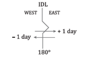
International Date Line (IDL)
Definition and Location
The International Date Line (IDL) is an imaginary line on the Earth’s surface that roughly follows the 180° longitude, opposite the Prime Meridian. It serves as the demarcation line for calendar dates.
Geographical Adjustments
- While the IDL ideally follows the 180° longitude, it deviates through the mid-Pacific Ocean and around several territories and island groups, including the Bering Strait between Siberia and Alaska, as well as Fiji and Tonga. These deviations are made to prevent the line from crossing nations and islands directly, which would result in a single political entity or landmass experiencing two different dates.
Date Change Mechanism
- Crossing the IDL results in a change of one calendar day. If you travel westward across the line, you add a day, whereas if you move eastward, you subtract a day. This adjustment is crucial for travel and communication across regions lying on either side of the IDL.
Indian Standard Time (IST)
Definition and Calculation
- Indian Standard Time (IST) is the time zone observed throughout India and Sri Lanka, with a time offset of UTC+5:30. This means IST is 5 hours and 30 minutes ahead of Coordinated Universal Time (UTC) or Greenwich Mean Time (GMT).
Geographical Reference
- The standard meridian for IST is 82°30’E, which passes through Mirzapur, near Allahabad in the state of Uttar Pradesh. This meridian was chosen to provide a single time zone for India, which spans over 29 degrees of longitude, from the westernmost point in Gujarat to the easternmost point in Arunachal Pradesh.
States along the IST Meridian
- In addition to Uttar Pradesh, the IST meridian passes through several states, including Madhya Pradesh, Chhattisgarh, Odisha, and Andhra Pradesh. This central location helps in minimizing the time difference across the country.
Significance and Impact
International Date Line
- Global Time Management: The IDL plays a crucial role in the global time-keeping system, ensuring that each day is consistent as it passes around the world.
- Travel and Communication: For travelers and communications spanning across the IDL, understanding the date change is vital to avoid confusion in scheduling and timekeeping.
Indian Standard Time
- Uniformity Across the Country: By adopting a single time zone, India ensures that all its regions follow the same time, simplifying governance, business, broadcasting, and daily life.
- Geopolitical Unity: Having a single time zone also fosters a sense of unity across the country, despite its vast geographical spread and diversity.
- Both the International Date Line and Indian Standard Time illustrate the complexities and necessities of global and regional time-keeping systems, reflecting both physical geography and human needs in their design and implementation.
Motions of The Earth
The Earth’s rotation is a critical astronomical phenomenon with far-reaching effects on the planet’s environment, climate, and the daily lives of all living organisms. This rotation refers to the Earth spinning around its own axis, which is an imaginary line that extends from the North Pole to the South Pole.
Rotation
- Direction of Rotation: The Earth rotates from west to east, which is observable through the apparent eastward movement of the Sun across the sky.
- Duration of One Rotation: The Earth completes one full rotation relative to the Sun in approximately 24 hours, defining the length of one solar day.
- Speed Variation: The rotational speed varies across the Earth’s surface; it is fastest at the equator and decreases toward the poles. At the equator, the surface speed is about 1670 kilometers/hour (1037 miles/hour).
- Axis Tilt: The Earth’s axis is tilted at an angle of approximately 23.5° relative to the perpendicular of its orbital plane. This tilt is responsible for the seasonal changes experienced on Earth.
- Effects of the Tilted Axis: Only one hemisphere of the Earth faces the Sun at a time, leading to the alternation between day and night. The tilt also results in varying angles of sunlight incidence, influencing seasonal temperatures.
Significant Impacts of Earth’s Rotation
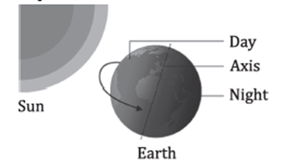
1. Day and Night Cycle:
- The most direct consequence of Earth’s rotation is the cyclical pattern of daylight and darkness experienced as day and night. This cycle is fundamental to the biological rhythms of many species, including humans.
2. Coriolis Effect:
- The rotation of the Earth gives rise to the Coriolis effect, which causes moving air and water to turn to the right in the Northern Hemisphere and to the left in the Southern Hemisphere. This effect is crucial for weather patterns and ocean currents.
3. Geographical Shape:
- Earth’s rotation causes it to have an oblate spheroid shape, slightly flattened at the poles and bulging at the equator. This deformation results from the centrifugal force generated by the Earth’s rotation.
4. Apparent Motion of Celestial Bodies:
- To an observer on Earth, the stars, planets, and the Moon appear to move from east to west across the sky. This apparent motion is a direct result of Earth’s west-to-east rotation.
5. Circle of Illumination:
- The dividing line between day and night on Earth’s surface is known as the circle of illumination. As the Earth rotates, this circle shifts, bringing different parts of the planet into sunlight or darkness.
Measurement and Units
- Degrees and Time: The Earth’s rotation is measured in degrees, with 360° representing a full rotation. This is divided into 24 hours, with each hour representing 15° of rotation.
- Minutes and Seconds: Degrees are further divided into minutes and seconds of arc (60 minutes per degree and 60 seconds per minute) to provide more precise measurements of Earth’s rotation.
Understanding the Earth’s rotation is crucial for various scientific fields, including astronomy, meteorology, and geography. It influences everything from the global climate system to the technology behind global positioning systems (GPS). The rotation of the Earth is a fundamental aspect of our planet’s dynamics, shaping the environmental and living conditions experienced by all Earth’s inhabitants.
Rotation
If the Earth did not rotate, it would have a profound impact on the planet’s environment and its ability to support life.
Climate Extremes
- Perpetual Day and Night: One half of the Earth would be in constant daylight, while the other half would be in eternal night. This would result in extreme temperature variations across the planet.
- Temperature Differences: The side of the Earth facing the Sun would experience continuous warmth, potentially creating a scorched desert landscape. In contrast, the dark side would be subjected to perpetual cold, likely becoming a frozen wasteland.
- Atmospheric Circulation: The lack of rotation would alter the pattern of atmospheric circulation, potentially preventing the redistribution of heat from the equatorial regions to the poles, which could exacerbate the temperature extremes.
Ecological Impact
- Habitability: The drastic differences in temperature and light would likely make the Earth uninhabitable for most forms of life as we know it. Ecosystems require a regular cycle of day and night to function properly.
- Ocean Currents: The currents of the ocean, which are driven in part by the rotation of the Earth, would be significantly altered, affecting global climate systems and marine ecosystems.
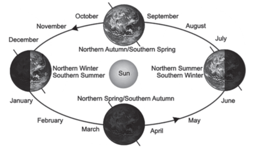
Earth’s Revolution Around the Sun
The revolution of the Earth around the Sun is a separate but equally important astronomical phenomenon that contributes to the conditions necessary for life on Earth.
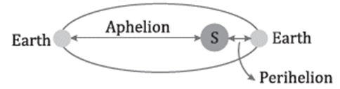
Orbital Characteristics
- Elliptical Orbit: The Earth’s orbit around the Sun is not a perfect circle but an ellipse, leading to varying distances from the Sun throughout the year.
- Duration of Revolution: It takes approximately 365 days and 6 hours for the Earth to complete one revolution around the Sun.
- Leap Year Adjustment: The extra 6 hours accumulated over four years are compensated for by adding an extra day to the calendar, resulting in a leap year every four years.
Perihelion and Aphelion
- Perihelion (Closest Approach to the Sun): This occurs around January 3rd when the Earth is approximately 147.5 million kilometers from the Sun.
- Aphelion (Farthest Distance from the Sun): This occurs around July 4th, with the Earth at a distance of about 152.2 million kilometers from the Sun.
Impact on Seasons
- Seasonal Variation: The revolution of the Earth, in combination with its axial tilt, is responsible for the changing seasons. The Earth’s tilt causes different hemispheres to receive varying amounts of sunlight throughout the year, resulting in seasonal climate changes.
- Equinoxes: During the equinoxes, around March 21 and September 21, the Sun is directly overhead at the equator, providing approximately equal day and night lengths across the globe.
Solar Altitude
- Definition: Solar altitude is the angle of the Sun relative to the Earth’s horizon. An angle of 90° means the Sun is directly overhead, casting no shadow at midday.
- Variation with Latitude: The altitude of the midday Sun varies with latitude and the Earth’s position in its orbit. At the equator, during the equinoxes, the Sun reaches a 90° angle relative to the horizon.
 Understanding the effects of the Earth’s rotation and revolution is crucial to grasp how these dynamics create the environment necessary for life and influence the diverse climatic and ecological systems on our planet.
Axial Tilt
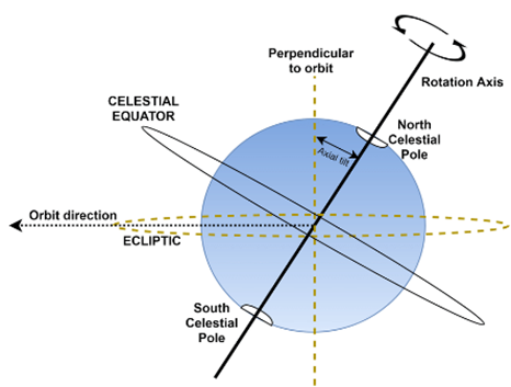
Axial tilt, also known as the obliquity of the ecliptic, is a fundamental concept in astronomy that plays a crucial role in shaping the climatic conditions and seasonal variations of a planet. This concept refers to the angle between a planet’s rotational axis and its orbital axis around the sun. Understanding axial tilt is essential for comprehending the diverse climates and seasonal changes that occur on different planets within our solar system.
Axial Tilt: Axial tilt is defined as the angle between a planet’s rotational axis and a perpendicular line to its orbital plane. This angle is crucial because it determines the amount of sunlight different parts of a planet receive during its orbit around the sun, thus affecting seasonal variations and climate.
Earth’s Axial Tilt
- Magnitude: Earth’s axial tilt is approximately 23.5 degrees. This specific angle is significant as it contributes to the familiar seasonal patterns observed on Earth, such as winter, spring, summer, and autumn.
- Obliquity of the Ecliptic: The term “obliquity of the ecliptic” is used synonymously with axial tilt when referring to Earth. It highlights the inclination of Earth’s axis in relation to its orbital plane around the sun.
- Relation to the Orbital Plane: Contrary to being perpendicular, Earth’s axis forms an angle of about 66.5 degrees with the plane of its orbit. This inclination is key to understanding the changing lengths of days and nights throughout the year.
Uranus
- Extreme Axial Tilt: Uranus stands out in the solar system with an axial tilt of approximately 98 degrees. This extreme tilt means that Uranus’s poles are almost in the plane of its orbit around the sun, leading to extreme seasonal variations.
- Polar Orientation: The significant tilt of Uranus results in one of its poles facing the sun directly at certain times in its orbit, causing prolonged periods of daylight or darkness over different parts of the planet.
Importance of Axial Tilt
- Seasonal Variation: Axial tilt is the primary reason for the variation in daylight hours and seasonal changes as a planet orbits the sun. The tilt causes different hemispheres to receive varying amounts of sunlight throughout the year, leading to seasons.
- Navigation and Star Location: Earth’s axial tilt also aids in navigation and the identification of stars in the night sky. Currently, Earth’s axis points towards Polaris, the North Star, making it a critical reference point for navigation. However, due to the precession of Earth’s axis—a wobble in its rotation—this orientation changes over millennia. In about 13,000 years, Earth’s axis is expected to point towards Vega, another prominent star, making it the North Star of that era.
- Axial tilt is a pivotal astronomical concept that influences the environmental and climatic conditions of planets. On Earth, the 23.5-degree axial tilt is responsible for the familiar seasons and the varying lengths of days and nights experienced throughout the year. In contrast, Uranus’s extreme tilt of about 98 degrees leads to unusual and extreme seasonal changes. Furthermore, the axial tilt facilitates navigation and the identification of celestial objects, although this orientation changes over long periods due to the precession of the axis. Understanding axial tilt is essential for grasping the dynamics of our planet and the broader solar system.
Axial Precession
Axial precession, a fundamental concept in celestial mechanics, describes the gradual shift or “wobble” in the orientation of an astronomical body’s axis of rotation. This phenomenon is most commonly associated with Earth but can apply to other celestial bodies as well.
Axial Precession
- Definition and Mechanics: Axial precession refers to the slow, conical movement of the Earth’s rotation axis. Imagine the Earth not as a stable spinning top but as one that slowly gyrates, causing the positions of the celestial poles and equinoxes to shift over time. This motion is akin to how a spinning top wobbles as its momentum decreases, although Earth’s wobble is due to gravitational forces rather than friction.
- Timescale: The cycle of this precession completes approximately every 25,770 years. This vast timescale means the effect on human observations of the sky is gradual and mostly noticeable over generations.
Causes of Axial Precession
- Gravitational Influences: The primary drivers of Earth’s axial precession are the gravitational forces exerted by the Sun and the Moon on Earth’s equatorial bulge. Earth is not a perfect sphere; it bulges at the equator due to its rotation. This bulge presents a handle, so to speak, for the Sun’s and Moon’s gravity to exert torque, causing the Earth to precess.
- Torque and the Equatorial Bulge: The torque results from the differential gravitational pull on the Earth’s equatorial bulge. As the Earth rotates, the Sun and the Moon pull on this bulge, attempting to align the Earth’s equatorial plane with the ecliptic plane. This tug-of-war creates the precessional motion, gradually altering Earth’s axial tilt.
Wobbling Effects Beyond Earth
- Wobbling of the Sun: Just as Earth experiences precessional motion, the Sun too wobbles due to gravitational influences, albeit on a much smaller scale. The Earth, despite its relatively small mass, contributes to this wobble. However, the most significant effect comes from Jupiter, the largest planet in the Solar System.
- Jupiter’s Influence: Jupiter’s massive gravitational field exerts a strong pull on the Sun, causing it to orbit a point just outside its own surface, known as the barycenter of the Solar System. This motion forms part of the Sun’s own “wobble” in space, with a cycle closely matching Jupiter’s orbital period of approximately 11.859 years.
- Axial precession is a complex but fascinating aspect of celestial mechanics, illustrating the interconnectedness of celestial bodies through gravitational forces. Earth’s precession affects our view of the stars and constellations over millennia, while the gravitational interactions within our Solar System cause even the Sun to wobble. These movements, governed by the laws of physics, highlight the dynamic and ever-changing nature of the universe.
Length of Day and Night
 The phenomenon of day and night is a direct consequence of the Earth’s rotation on its axis. This daily rotation means that different parts of the Earth are exposed to sunlight at different times, creating day and night in a continuous cycle. However, the experience of day and night is not uniform across the globe. Factors such as the Earth’s tilted axis and its orbit around the Sun play significant roles in varying the length of day and night.
Earth’s Tilt and Its Effects
The Earth’s axis is tilted at an angle of approximately 23.5 degrees from the plane of its orbit around the Sun. This tilt is responsible for the seasonal changes experienced by various regions of the Earth. As the Earth revolves around the Sun, this axial tilt means that different hemispheres receive varying amounts of sunlight at different times of the year.
- Equinoxes: During the equinoxes, which occur in March and September, the tilt of the Earth’s axis is such that the Sun is directly over the equator. This results in nearly equal lengths of day and night across the globe.
- Solstices: The solstices, occurring in June and December, mark the points in the Earth’s orbit when one hemisphere is tilted most towards or away from the Sun. During the June solstice, the Northern Hemisphere experiences the longest day of the year, while the Southern Hemisphere has its shortest day. The opposite occurs during the December solstice.
Polar Variation
Polar variation refers to the differences in how the poles (the northernmost and southernmost points of the Earth) experience day and night compared to the rest of the planet. This variation is also a result of the Earth’s axial tilt and its orbit around the Sun. Moreover, the concept of “poles” on Earth can be understood in three distinct contexts:
- True North or South Poles: These are the points at the northern and southern ends of the Earth’s axis of rotation. They are the geographic poles, around which the Earth spins. The True North Pole is located in the Arctic Ocean, while the True South Pole is on the continent of Antarctica.
- Geomagnetic Poles: The Earth’s core generates a magnetic field due to the dynamo effect, where the motion of molten iron alloys in the outer core generates electric currents. The geomagnetic poles are the points where the axis of this magnetic field intersects the Earth’s surface. These poles are slightly tilted relative to the Earth’s axis of rotation, causing the magnetic field lines to emerge at angles. The Earth behaves like a giant magnet, with these geomagnetic poles acting as the points of magnetic attraction.
- Magnetic Poles: Distinct from the geomagnetic poles, the magnetic poles are defined by the orientation of Earth’s magnetic field at the surface. The Magnetic North Pole is the point where the magnetic field lines are directed vertically downwards. It is the location towards which all magnetic compasses point. Unlike the true and geomagnetic poles, the magnetic poles move over time due to changes in the Earth’s magnetic field.
- The cycle of day and night, as well as the variations in their lengths, are fascinating outcomes of the Earth’s rotation, its axial tilt, and its orbit around the Sun. Understanding the different types of poles and their roles further enriches our comprehension of Earth’s complex and dynamic nature. These variations not only influence our perception of time but also affect the environment and living conditions across different parts of the world.
Eclipses
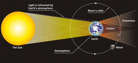
Eclipses
Eclipses represent one of the most fascinating astronomical events, occurring when a celestial object moves into the shadow of another, casting a shadow that either partially or fully obscures the former from view. This phenomenon is contingent upon the alignment of three celestial bodies in a straight line, a configuration known as syzygy. On Earth, eclipses are primarily observed as either solar or lunar, resulting from the specific orientations and movements of the Earth, Moon, and Sun.
Types of Eclipses
Eclipses are categorized into two main types based on the celestial bodies involved and their interactions:
Solar Eclipse
A solar eclipse transpires when the Moon positions itself between the Earth and the Sun, effectively casting its shadow upon the Earth. This phenomenon can only occur during a new moon, when the Moon’s orbit intersects the plane of the Earth’s orbit around the Sun. Observers within the path of the Moon’s shadow experience a solar eclipse, which can manifest in one of three forms:
- Partial Solar Eclipse: This occurs when the Sun, Moon, and Earth are not in perfect alignment, resulting in only a portion of the Sun being obscured by the Moon.
- Annular Solar Eclipse: Characterized by the appearance of a bright, annular ring, this type of eclipse occurs when the Moon is at its farthest point from the Earth (apogee), and thus, its apparent size is not large enough to entirely cover the Sun.
- Total Solar Eclipse: A total solar eclipse is observed when the Sun is completely obscured by the Moon, with the three celestial bodies aligning perfectly. This rare alignment plunges a specific area on Earth into temporary darkness, allowing observers to witness the Sun’s corona.
Lunar Eclipse
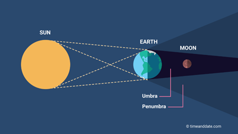
Lunar eclipses present an intriguing celestial phenomenon that occurs when the Earth positions itself directly between the Sun and the Moon. This alignment results in the Earth casting its shadow upon the Moon. For a lunar eclipse to take place, the Sun, Earth, and Moon must be closely aligned in a straight line, an arrangement known as syzygy, specifically during a full moon. This alignment causes the Moon to pass through the Earth’s shadow, leading to various types of lunar eclipses depending on the extent of the Moon’s immersion into the Earth’s shadow.
Alignment Required for a Lunar Eclipse
The precise alignment for a lunar eclipse is Sun – Earth – Moon. This means that the Earth obstructs the Sun’s light from reaching the Moon, casting a shadow over it. The occurrence of a lunar eclipse is exclusive to the phase of the full moon, when the Moon’s orbit brings it into direct alignment with the Earth and Sun.
Types of Lunar Eclipse
Lunar eclipses can be categorized into three primary types, distinguished by how much of the Moon’s surface is obscured by the Earth’s shadow:
- Penumbral Lunar Eclipse: This type occurs when the Moon passes through the Earth’s penumbral shadow. In this scenario, the eclipse is subtle and hard to observe, as only a slight shadow appears on the Moon’s surface.
- Partial Lunar Eclipse: A partial lunar eclipse happens when only a part of the Moon enters the Earth’s umbral shadow. This results in a clear demarcation where part of the Moon is significantly darker than the rest. Observers can see a noticeable shadow on a portion of the Moon, making it an easier eclipse to spot than a penumbral eclipse.
- Total Lunar Eclipse: The most dramatic and visually striking type of lunar eclipse is the total lunar eclipse. It occurs when the Sun, Earth, and Moon align perfectly, causing the Earth to cast a full shadow (umbra) over the Moon. During totality, the Moon can appear to take on a reddish color, earning it the nickname “Blood Moon.” This reddening effect is due to Rayleigh scattering, the same atmospheric effect that causes sunsets and sunrises to appear red on Earth.
UPSC PREVIOUS YEAR QUESTIONS
1. In the northern hemisphere, the longest day of the year normally occurs in the: (2022)
(a) First half of the month of June
(b) Second half of the month of June
(c) First half of the month of July
(d) Second half of the month of July
2. On 21st June, the Sun: (2019)
(a) does not set below the horizon at the Arctic Circle
(b) does not set below the horizon at Antarctic Circle
(c) shines vertically overhead at noon on the Equator
(d) shines vertically overhead at the Tropic of Capricorn
3. Variations in the length of daytime and night time from season to season are due to: (2013)
(a) The earth’s rotation on its axis
(b) The earth’s revolution around the sun in an elliptical manner
(c) Latitudinal position of the place
(d) Revolution of the earth on a tilted axis
4. Westerlies in the southern hemisphere are stronger and persistent than in northern hemisphere. Why? (2011)
1. Southern hemisphere has less landmass as compared to northern hemisphere.
2. Coriolis force is higher in southern hemisphere as compared to northern hemisphere
Which of the statements given above is/are correct?
(a) 1 only
(b) 2 only
(c) Both 1 and 2
(d) Neither 1 nor 2
5. What could be the main reason/reasons for the formation of the African and Eurasian desert belt? (2011)
1. It is located in the sub-tropical high-pressure cells.
2. It is under the influence of warm ocean currents.
Which of the statements given above is/are correct in this context?
(a) 1 only
(b) 2 only
(c) Both 1 and 2
(d) Neither 1 nor 2