Typhoon Ragasa: Strongest Storm of 2025 Explained
Super Typhoon Ragasa (2025): Key Features & Naming System
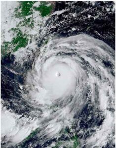
In September 2025, Super Typhoon Ragasa struck several East Asian regions, including the Philippines, Taiwan, Hong Kong, Macau, and southern China. Originating around September 17 in the western Pacific as a tropical depression, Ragasa intensified rapidly over warm ocean waters to become a severe typhoon. According to the Japan Meteorological Agency, it reached a central pressure of 905 hPa with maximum sustained winds of ~205 km/h (10-minute sustained), approaching its maximum potential intensity for the environmental conditions.
Known locally in the Philippines as Nando, Ragasa wreaks havoc across the affected areas. The super typhoon resulted in over 25 fatalities, numerous injuries, and mass displacement. The disaster response teams were overwhelmed by the scale of destruction.
As Ragasa approached Hong Kong, the Hong Kong Observatory issued typhoon signal 10—the highest level—for nearly 11 hours, making it the second-longest duration for that signal in Hong Kong history. This prompted authorities to issue red alerts and evacuation orders for low-lying areas. In affected zones, torrential rain exceeded 200 mm in some districts, triggering flash floods, a dangerous storm surge, and the risk of barrier lake bursts in mountainous regions. More than 1,200 trees were uprooted, mudslides occurred, and transport services and flights were severely disrupted, with numerous flight cancellations reported.
Ragasa later made landfall in Hailing Island, Guangdong Province, before weakening over land. The typhoon’s right-front quadrant, known for its hurricane-force winds, caused significant damage to coastal infrastructure and led to seawater intrusion in several areas.
The name “Ragasa”, meaning rapid movement or strong rush in Filipino, was submitted by the Philippines as part of the ESCAP/WMO Typhoon Committee’s rotating naming list for the Western North Pacific and the South China Sea. Fourteen member nations (e.g. Japan, China, Korea, Thailand) contribute names, which are used sequentially to avoid confusion and for cultural neutrality. Unlike Atlantic hurricanes which often use human names, this system emphasises neutral, place-based or concept names.
In 2025, several other significant typhoons preceded Ragasa (e.g. Wutip, Sepat, Danas, Krosa) in the Pacific season. The rotating circulation of these storms, moving in an anti-clockwise direction in the Northern Hemisphere, is a key feature tracked by meteorological forecasting systems. For exams, also remember: India contributes cyclone names in the North Indian Ocean (e.g. Gati, Nisarga, Tauktae). This structured naming helps in systematic tracking, historical records, and public warnings, allowing authorities to better prepare for a typhoon’s forward motion and potential impact.