
NASA-ISRO Radar Satellite to Launch in June
NASA-ISRO Radar Satellite to Launch in June
Why in the News ?
ISRO Chief Dr. V. Narayanan announced that the NASA-ISRO radar satellite (NISAR) will be launched next month, along with updates on the G20 climate satellite, RA-SAT launch, and Gaganyatri ISS mission, highlighting India’s growing space collaborations and ambitions.
Key Announcements by ISRO Chief :
- ISRO chairman V. Narayanan revealed that the NASA-ISRO SAR satellite will likely launch next month.
- The satellite includes two major payloads – one made by India, the other by the United States.
- It is a microwave remote sensing satellite aimed at monitoring Earth’s surface changes, particularly environmental and disaster-related data.
- On May 18, ISRO will launch RA-SAT, a C-band synthetic radar satellite, using the PSLV rocket.
India’s G20 Climate Satellite Initiative
- During India’s G20 Presidency, PM Narendra Modi proposed a G20 satellite to monitor climate-related activities.
- The satellite will carry 50% payload from India, with the rest from G20 partner countries.
- It will be launched on an Indian launch vehicle and its data shared among G20 nations for collective climate action.
Gaganyatri and Academic Highlights:
- The Gaganyatri mission will send Indian astronauts to the International Space Station (ISS) next month to gain practical experience.
- At the 5th Convocation of Central Agriculture University, 1,500+ students received degrees.
- Gold medals were awarded to 33 UG and 20 PG students, and 9 PhD scholars received the Akoijam Udhab Singh Memorial Award.
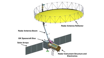
About the NISAR Mission – Key Points● NISAR (NASA-ISRO Synthetic Aperture Radar) is a joint Earth observation mission by NASA and ISRO, formalized in 2014. ● Scheduled for launch in June 2025 from Satish Dhawan Space Centre using GSLV Mk II. ● First radar-based Earth monitoring collaboration between India and the U.S. ● Will map the entire Earth’s surface every 12 days. ● Tracks ecosystem shifts, ice dynamics, sea level rise, vegetation, and natural hazards. ● Radar payload captures surface and geophysical changes. ● 12-metre wire mesh reflector enhances imaging. ● Features gold thermal blankets, spacecraft bus for power, communication, and control. |


