FREQUENT MASS WASTING IN TIBET A CAUSE FOR WORRY IN INDIA
Relevance:
GS 1 – Distribution of key natural resources across the world (including South Asia and the Indian sub-continent); Important Geophysical phenomena such as earthquakes, Tsunami, Volcanic activity, cyclone etc.
GS 3 – Disaster and disaster management.
Why in the news?
- Geological events have been on the rise since 2017 in the Sedongpu Gully watershed drained by the Yarlung Tsangpo River on the Brahmaputra in Assam.
- A recent study has highlighted the high frequency of pollution, especially since 2017, in Sedongpu Bay in the Tibetan Plateau.
More about the news
- These events are associated with extreme heat waves in the region, where temperatures rarely exceeded 0º C prior to 2012.
- Mass dissipation is the movement of rocks and soil down a slope by gravity. Flow caused by splashes, crowd movement, or both.
- Studies suggest that this change could have a negative impact on India, especially on the Northeast region.
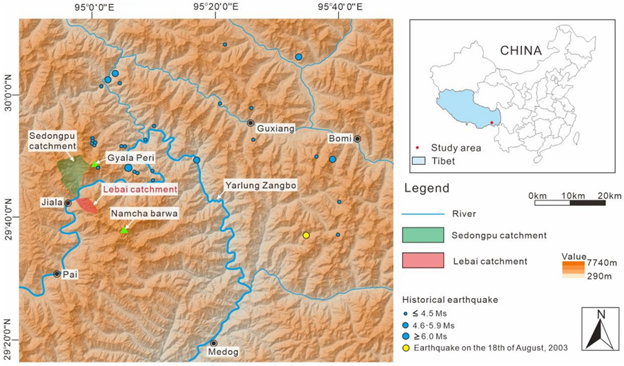
Sedongpu Gully and the Great Bend of the Tsangpo River
Sedongpu Gully:
- It is located in the Sedongpu Glacier and its valley. The valley is 11 kilometers long and covers an area of 66.8 square kilometres.
- Near Great Bend, it flows into the Yarlung Zangbo (Tsangpo) River.
The Great Bend:
- It comes where the Tsangpo River meanders around Namcha Barwa Peak (7,782 m) and Gyala Peri Peak (7,294 m).
- It is a 505 km long and 6,009 meter deep canyon, one of the deepest canyons on Earth.
- It is located near the border of Arunachal Pradesh in Tibet, where the Tsangpo River flows as the Siang River.
- Confluence of the river: In Assam, below the Great Bend, the Siang River joins the Diwang and Lohit rivers to form the Brahmaputra. Jamuna, the son of Brahma, flows in Bangladesh.
Research findings and implications
- The Publication was written by Weile Li of Chengdu University of Technology in China and five other researchers.
- It was published August 2 in the Journal of Rock Mechanics and Geotechnical Engineering.
- Since 2017, more than 700 million cubic meters of debris have accumulated in the Sedongpu Gully reservoir.
- Increased seismic activity is due to prolonged warming and intense local seismicity induced by earthquakes.
- The remoteness of the area limited human impact.
- Environmental Concerns: Environmental scientists in Assam consider the findings of the study alarming for the river bottom, including areas hundreds of kilometers away.
- The risk is aggravated by the presence of large reservoirs due to the 510 MW Zangmu on the Tsangpo River and India-planned projects on the Siang River.
River slides and flash floods
Partha Jyotidas, Head of Hydrology and Climate Hazards Department at Aranyak (Guwahati-based Biodiversity Research Organisation) Assam-Tibet (Medog) magnitude 8.6 earthquake in 1950, Nyingchi earthquake magnitude 6.4 in November 2017.
Sedongpu Course:
- The study of the Sedongpu has important implications for the Tsangpo-Siang-Brahmaputra-Jamuna river system that connects India and Bangladesh in particular.
- The study used satellite data from December 1969 to June 2023 to analyze landslides in the Sedongpu Gully watershed.
- The 149 satellite images revealed 19 major weed events or clusters of events, classified into three subscales: ice-rock avalanche (IRA), ice-moraine avalanche (IMA), and glacier debris flow (GDF).
- Ice – rock avalanche (IRA) debris temporarily blocked the flow of the Tsangpo River and its tributary, the Yigong River.
- The breach of these barriers resulted in catastrophic flooding in the downstream areas.
- In 2000, the floods occurred in East Siang town in Arunachal Pradesh and Dhumaji district in Assam due to the bursting of a dam built by the Yigong River
- The dam was formed by snow and rocks formed during a major earthquake.
- A possible global rise in water levels in one of the old watersheds could make matters worse.
Depressive effects:
- China’s hydropower projects: China plans to build a 60-gigawatt hydroelectric project on the Tsangpo River, tripling the capacity of the world’s largest hydroelectric power plant, the Yangtze River Three Rivers Project.
- The Brahmaputra river carries more than 800 million tonnes of sewage to Pandu in Guwahati, rising to more than one billion tonnes in Bahadurabad in Bangladesh.
- Dr Das cautioned that it could intensify the construction of the river on an irregular plain, leading to further coastal erosion.
- Rising tides can increase the risk of flooding, and in the dry season, the channels are choked with sand and silt, causing shipping damage and affecting fishing livelihoods
Sluggish before hyperactivity in Sedongpu Gully
Original events:
- The first several extensive damages occurred between 1974 and 1975 at Sedongpu Gully.
- Subsequent satellite imagery did not show any disaster until 1987.
- Two ice melts (IMAs) occurred in 1998 and 2000, followed by relative calm from 2001 to 2017.
Increased activity after 2017:
- “In 2017, the bridge became very active, starting with an intense ice and rock avalanche (IRA) from October 20-27, which temporarily blocked the Yarlung Tsangpo River
- This timing was associated with the Nyingchi earthquake, whose epicenter was only 8 km from the crater mouth, causing deformation of the rocks and ice
- From November to December 2017, three consecutive glacial debris (GDF) events
- In 2018, two dangerous “unexpected” IRAs completely blocked Tsangpo and created another 300-meter-deep trench.
- Overall, 13 (68.4%) of the 19 recorded events occurred after 2017, resulting in a significant increase in activity.
Soil survey:
- The basement rocks of the Sedongpu Basin are mainly Proterozoic marbles.
- Surface temperatures in the area range from -5º to -15º C, rarely exceeding 0º C before 2012.
- Data from weather stations near Bomi and Linzhi show that the average annual temperature in the area increased from 0.34º to 0.36º C between 1981-2018, the highest in the world.
A call to action:
- Das emphasized the importance of conducting similar studies to monitor geological processes such as soil erosion and rock fall.
- This study is important for the understanding of the impacts on the geohydrological system of the Brahmaputra River and its tributaries, and the management of erosion.
The Way forward
- Enhanced Monitoring: Continuous satellite ground monitoring of land use in the Sedongpu Gully areas was used to detect real-time changes.
- Research collaboration: Encourage collaboration between Indian and Chinese researchers to share data and insights on soil processes and their impact on Brahmaputra river system.
- Disaster Preparedness Strategy: Develop and update plans for disaster preparedness of communities in Northeast India, with a focus on flood risk associated with extensive damage.
- Environmental assessment: A comprehensive environmental assessment should be carried out for any proposed projects in the area to understand the potential impact on soil stability and river system on the bottom.
- Climate Change Mitigation: Advocate for policies aimed at reducing the impact of climate change, which contributes to increasing common land issues.
- Public awareness campaign: To raise awareness of the dangers of massive damage and flooding in local communities, and educate them on emergency preparedness measures.
- Sustainable Development Practices: Promote sustainable land use and development practices in the region to reduce anthropogenic impacts on soil energy stability.
- International engagement: Participate in international discussions on transboundary river management and environmental protection, especially the Brahmaputra River and its tributaries.
- Funding for research: Availability of funding for additional research on landscape strategies affecting areas, with a focus on long-term effects and mitigation options.
Alteranaitve articles
https://universalinstitutions.com/chapter-5-geomorphic-processes-2/
https://universalinstitutions.com/protest-against-upper-siang-hydropower-project/
Mains question
Discuss the impact of increased destructive events in the Sedongpu Gully of the Tsangpo-Siang-Brahmaputra river system with special reference to sedimentation and low impacts in India and Bangladesh. ” (250 words).