SIACHEN: 40 YEARS OF OP MEGHDOOT
Relevance: GS 3 – Security challenges and their management in border areas
Why in the News?
- April 13, 2024, marks 40 years since the Indian Army preemptively occupied the Siachen glacier.
- The glacier is located on the Saltoro ridge, overlooking the Nubra valley in the Karakoram ranges.
- A ceasefire is currently in place between the Indian and Pakistani forces.
- The military operation initiated on that day is ongoing.
About Siachen Glacier
- The Siachen Glacier is located at an altitude of 15,632 feet.
- The ongoing conflict between India and Pakistan on the icy glacier.
- April 13, 2024, marks 40 years since the Indian Army preemptively occupied the glacier on the Saltoro ridge which overlooks the Nubra valley in the Karakoram ranges.
- Extreme weather conditions are the primary challenge on the glacier.
- Approximately 1,150 soldiers have lost their lives on the glacier, with the majority succumbing to extreme weather.
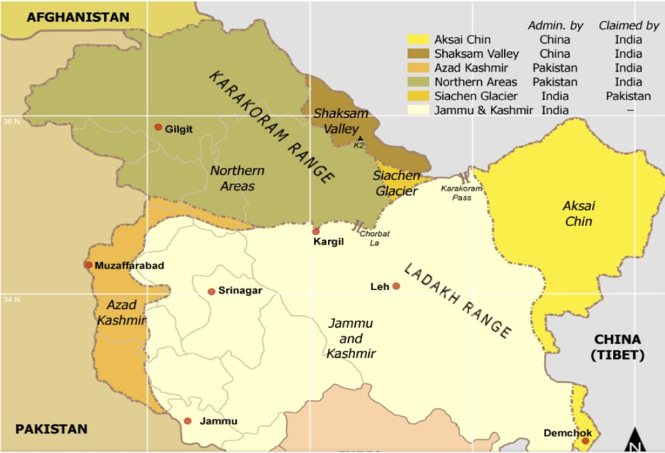
Siachen: The “Land of Roses”
- Meaning in Balti Language: Siachen translates to “land of roses” in the Balti language. “Sia” refers to a local rose species, and “Chen” means “in abundance.”
- Extreme Battlefield: Despite its floral name, Siachen is recognized as the world’s highest and coldest battlefield. Strategically located, it lies between Pakistan on the left and China on the right.
- Historical Context: Siachen’s conflict is a legacy of the Partition between India and Pakistan.
- The Line of Control (LoC) was delineated up to NJ-9842 in the 1972 Simla agreement, leaving the glacier itself undefined.
- Claims and Interpretations: India claims the area based on the Jammu and Kashmir Accession Agreement of 1947 and the Karachi Agreement of 1949.
- These agreements describe the ceasefire line as running “Northwards to the glaciers.”
- Pakistan interprets the agreement as running “North-Eastwards,” aiming to claim the area beyond the Saltoro Ridge and Siachen.
- Strategic Implications: Pakistan’s claim could provide it with direct connectivity to China.
- It would also give Pakistan strategic oversight over the Ladakh region and the vital Leh-Srinagar highway, posing a significant threat to India.
The Genesis and Evolution of Operation Meghdoot
- Cartographic Aggression by Pakistan: In the 1970s and 1980s, Pakistan allowed foreign mountaineering expeditions to support its territorial claims.
- Preemptive Action by India: Due to intelligence indicating imminent military action by Pakistan in early 1984, India moved to preemptively secure the region.
- Role of Col. Narinder ‘Bull’ Kumar: Mountaineering expeditions led by Col. Narinder ‘Bull’ Kumar to the Siachen glacier and Saltoro range were instrumental.
- As Commandant of the High Altitude Warfare School (HAWS), Kumar’s recce reports facilitated the planning for Operation Meghdoot.
Launch of Operation Meghdoot
- ‘Operation Meghdoot’ was launched on April 13, 1984, to capture the 76.4 km-long glacier.
- A platoon of 4 Kumaon, led by then Captain Sanjay Kulkarni, planted the Indian flag at Bilafond La at an altitude of 18,000 feet.
- Ladakh Scouts were deployed via Cheetah helicopters by the Indian Air Force (IAF).
- Early Involvement of IAF: IAF helicopters began operating in the glacier in October 1978.
- Capture of Quaid Post and Renaming
- In June 1987, under ‘Operation Rajiv,’ Indian troops captured the Quaid post at 21,153 feet.
- The post was later renamed Bana top in honor of Naib Subedar Bana Singh from 8-Jammu and Kashmir Light Infantry (JAK LI), who was awarded the Param Vir Chakra for his bravery.
- Ceasefire and Ongoing Operation
- From 1984 to 2003, regular exchanges of fire occurred between the two sides.
- A ceasefire agreement was established in 2003 along the Line of Control (LoC) and the 110km long Actual Ground Position Line (AGPL) in Siachen.
- While the LoC has experienced occasional flare-ups, the ceasefire along the AGPL has remained intact.
- Operation Meghdoot continues to this day, making it the longest ongoing military operation in the world.
A Test of Endurance on the Siachen Glacier
- Height of Army Posts
- Army posts are situated at heights of 18,000 feet and above on the glacier. The Bana post is the highest, and Indira Col marks the highest point.
- Between 18,000-19,000 feet, Indian and Pakistani posts directly face each other.
- Beyond 20,000 feet, the territory is solely controlled by India.
- Challenges and Operations
- Operations on Siachen are a rigorous test of human endurance and skill.
- Early stages of Operation Meghdoot faced challenges due to limited high altitude clothing and equipment.
- IAF Operations
- Initially, IAF operations involved helicopters and transport aircraft.
- Fighter operations began in September 1984 when a detachment of Hunter aircraft from the No. 27 squadron started operations from the high altitude airfield at Leh.
- Live armament sorties were later carried out at the high altitude firing range at Kar Tso, south of Leh, as reported by the IAF.
- The IAF introduced Cheetal helicopters to the glacier in 2009. The Cheetal is a re-engineered Cheetah helicopter with improved reliability and higher load carrying capability at high altitudes.
Recent Developments on the Siachen Glacier
- Technological and Logistical Improvements: Significant advancements have been made in habitat, communications, mobility, logistics, and medical support over the past four decades.
- The glacier has benefited from improvements in technology and logistical support to enhance operations and save lives.
- Impact of Climate Change
- The glacier has been affected by climate change.
- In 2015, the glacier’s snout, the starting point at the base camp, receded by over a kilometre compared to its 1984 position.
- Communication Upgrades
- Mobile and data connectivity has improved considerably.
- The introduction of VSAT technology has revolutionized communication on the glacier, providing troops with data and internet connectivity.
- This technology upgrade has enhanced real-time situational awareness, telemedicine capabilities, and soldier well-being by allowing them to stay connected with their families.
- Mobility and Supply Enhancements
- All-Terrain Vehicles (ATVs) and ATV bridges have improved mobility across the glacier.
- The induction of Chinook heavy-lift helicopters and logistic drones has significantly enhanced the supply of essential provisions to isolated posts during winters.
- Special clothing, mountaineering equipment, advanced rations, and timely weather updates enable soldiers to better withstand temperatures as low as -60 degrees Celsius.
- Aircraft Support: Nearly all aircraft of the IAF, including Rafale, Su-30MKI, Chinook, Apache, Advanced Light Helicopter Mk III & Mk IV, Light Combat Helicopter Prachand, MiG-29, Mirage-2000, C-17, C-130 J, IL-76, and An-32, operate in support of Operation Meghdoot.
- Helicopters remain vital for supporting troops in remote posts, with the IAF’s 114 helicopter unit and Army aviation playing a crucial role.
- Medical Facilities: Telemedicine nodes established by ISRO serve forward posts.
- Medical facilities in Partapur and Base Camp include some of the country’s best medical and surgical specialists.
- These facilities feature state-of-the-art high altitude pulmonary oedema (HAPO) chambers, oxygen generation plants, and life support systems.
Future Prospects for Siachen
- Complexity in the India-Pakistan Conflict: Siachen and Sir Creek have been termed “low-hanging fruits” in the India-Pakistan conflict, given the more complex Kashmir issue.
- Dialogues and Stance on Siachen
- India and Pakistan have discussed Siachen at the Defence Secretary level.
- India has expressed willingness for demilitarisation but insists on authenticating the 110 km Actual Ground Position Line (AGPL) as the initial step, which Pakistan has rejected.
- Strategic Importance Highlighted by Army Chief:
- In January 2020, then Army Chief Gen. Manoj Mukund Narvane emphasized Siachen’s significance as the area facing the maximum collusive threat from China and Pakistan.
- Geopolitical Considerations:
- Siachen overlooks the Shaksgam valley, a part of Pakistan Occupied Kashmir (POK).
- The area adjacent to Siachen was ceded by Pakistan to China in 1963, following the 1962 India-China war.
- The 2020 standoff with China in Eastern Ladakh and ongoing tensions along the Line of Actual Control have further complicated any potential settlement of the Siachen issue.
- Siachen’s Changing Status: Given the geopolitical complexities and strategic importance, Siachen is no longer considered a “low-hanging” fruit in the India-Pakistan conflict.
Source: https://www.thehindu.com/news/national/siachen-40-years-of-op-meghdoot/article68069363.ece/amp/
Mains Question
Discuss the strategic significance and ongoing challenges associated with the Siachen Glacier in the India-Pakistan conflict. How have recent developments and geopolitical considerations affected the prospects for a resolution in the region? (250 words)