SATELLITE WEATHER TRACKING
Why in the News?
- Since December 2023, North India, including Bihar, UP, Uttarakhand, Haryana, Delhi, and Punjab, has faced dense fog.
- On January 16, the India Meteorological Department (IMD) used maps from INSAT 3D and INSAT 3DR satellites to issue warnings.
Source: Pti graphics
 Source: Pti graphics
About INSAT 3D and INSAT 3DR :
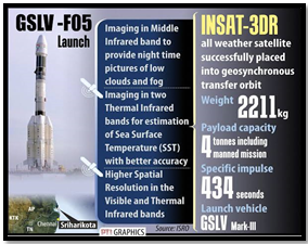
- INSAT-3DR stands as a technologically advanced weather satellite.
- Launched into orbit by GSLV-F05.
- Designed to complement and enhance the services provided by its predecessor, INSAT-3D.
- Positioned in a Geo Stationary Transfer Orbit (GTO) for effective weather monitoring and data collection.
- INSAT 3D uses an Red-Green-Blue (RGB) imager to represent solar reflectance and brightness temperature, determining colours.
- INSAT 3D and INSAT 3DR use radiometers for spectral measurements and atmospheric sounders to study temperature and humidity.
- INSAT 3D and INSAT 3DR are currently active in geostationary orbits
- Combining radiometer and sounder data helps understand atmospheric characteristics and track weather events.
| About Night microphysics
· Night microphysics involves complex colour determination based on differences between thermal infrared signals. · “Night Microphysics” reveals cloud types, thunderstorm stages, identifies snow areas, and detects fires. |