NISAR: India and NASA’s Landmark Earth-Observation Satellite to Launch on June 18, 2025
NISAR: India and NASA’s Landmark Earth-Observation Satellite to Launch on June 18, 2025
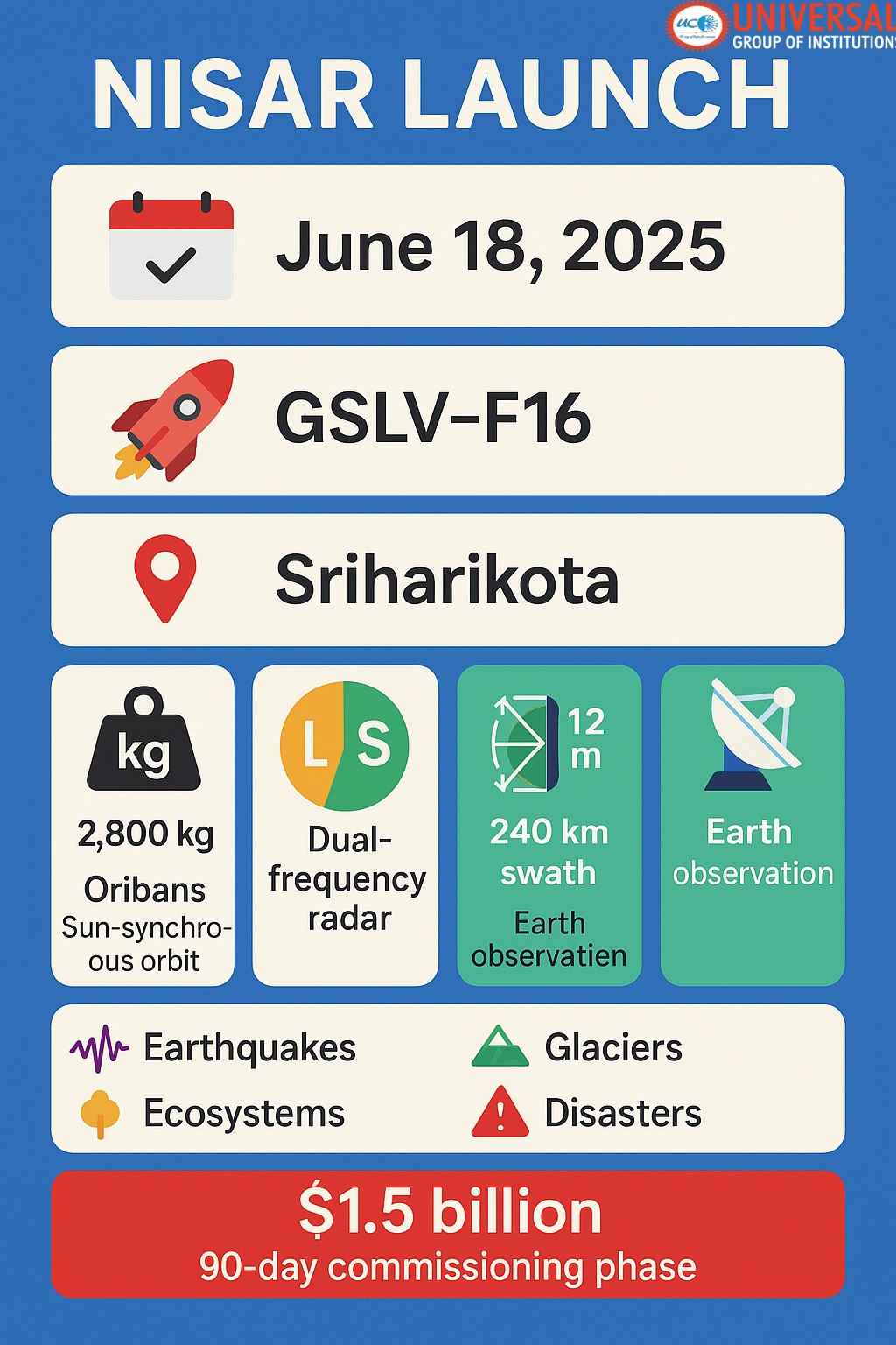
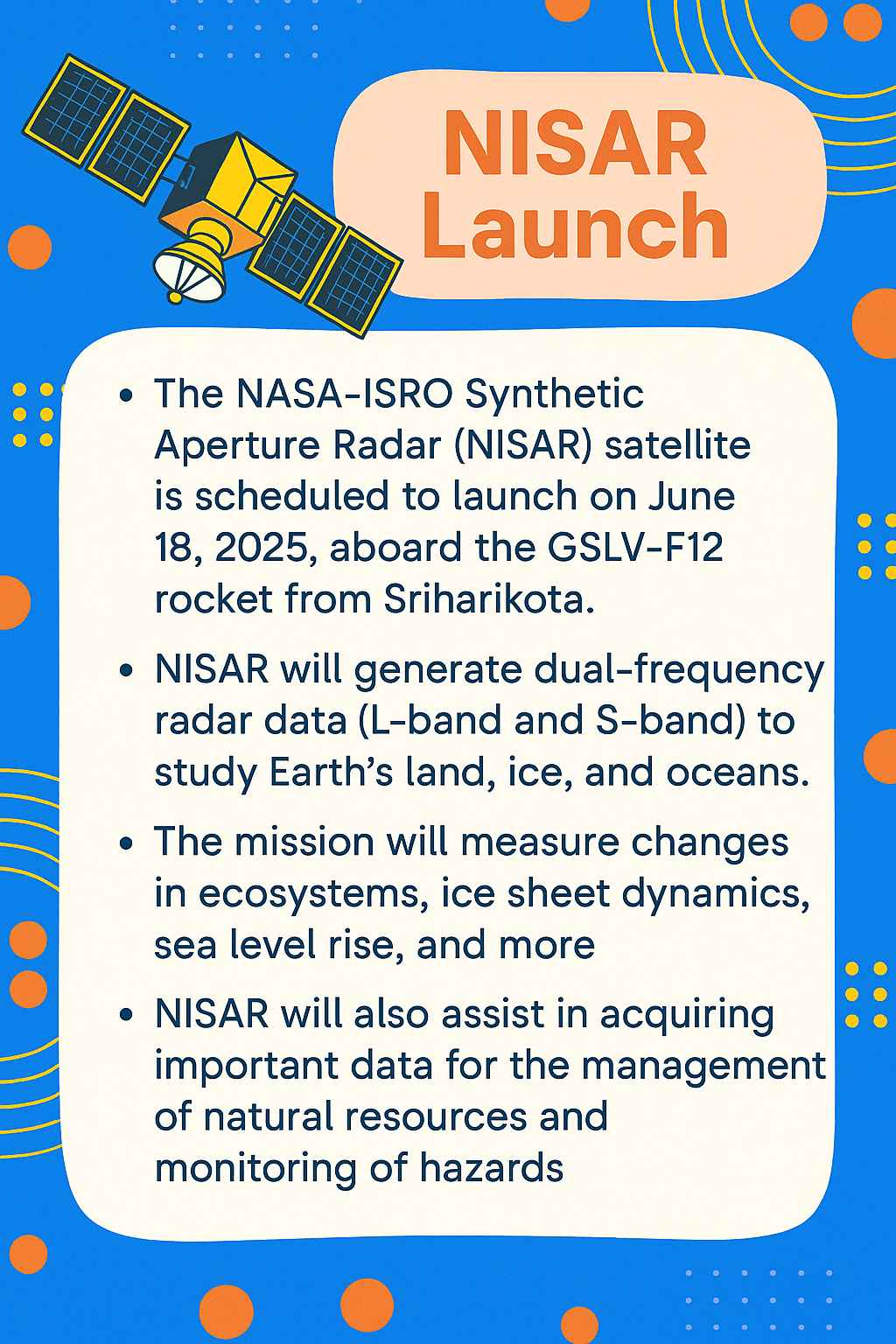
In a significant leap for international space collaboration and Earth sciences, the NASA-ISRO Synthetic Aperture Radar (NISAR) satellite, a groundbreaking NISAR project, is set to launch on June 18, 2025. This NISAR satellite launch will take place aboard ISRO’s GSLV launch vehicle from the Satish Dhawan Space Centre, Sriharikota. The NISAR launch date in 2025 marks a crucial milestone for this joint Earth observation mission. A joint initiative showcasing the NASA-ISRO collaboration, the NISAR satellite is poised to become the world’s most expensive satellite for Earth observation, utilizing cutting-edge dual-frequency radar technology. The importance of this mission is underscored by its inclusion in the NISAR satellite UPSC syllabus, highlighting its relevance for civil service aspirants and emphasizing the growing NASA Indian partnership. This collaboration is further strengthened by the presence of a NASA office in India, facilitating seamless coordination between the two space agencies.
What is NISAR?
NISAR, which stands for NASA-ISRO Synthetic Aperture Radar (NISAR full form), is a first-of-its-kind Earth observation satellite that will use two different radar frequencies—L-band (provided by NASA) and S-band (developed by ISRO)—to capture high-resolution imagery of the Earth’s surface, regardless of weather conditions or time of day. This NISAR radar system employs cutting-edge dual-frequency radar technology, including L-band SAR operating at a 24 cm wavelength and S-band SAR at a 9 cm wavelength, to achieve unprecedented Earth observation capabilities, including advanced interferometric measurements. The collaboration between NASA and ISRO on this project exemplifies the growing NASA ISRO collaboration, bridging the gap between NASA vs ISRO and showcasing the complementary strengths of both space agencies. This partnership highlights the difference between ISRO and NASA in terms of expertise and resources, while demonstrating their shared commitment to scientific advancement.
Weighing approximately 2,800 kg, the SUV-sized satellite will orbit the Earth at a 747 km orbit altitude in a sun-synchronous dawn-to-dusk orbit, ensuring consistent lighting conditions for its observations. The NISAR mission is designed for a 3-year mission duration, with the possibility of extension based on fuel reserves and operational stability. The NISAR satellite, also known as NISAR upgrah in Hindi, represents a significant milestone in ISRO satellite development and is a key addition to the ISRO missions list and upcoming ISRO missions. It is one of the most anticipated ISRO future missions, showcasing the agency’s commitment to advanced Earth observation technologies.
The NISAR satellite is equipped with a 12m deployable mesh antenna and a 9-meter boom to facilitate wide-swath radar imaging. Power for the satellite is supplied through large solar arrays capable of generating around 6,500 watts. The satellite’s left-facing instruments are designed to optimize data collection during its orbit. NISAR will utilize the innovative Sweep SAR technique to capture high-resolution images with a 3-10 m resolution, operating on a 12-day repeat cycle to provide consistent global coverage.
Scientific Goals and Applications
The key scientific objective of NISAR is to monitor Earth’s dynamic processes with unmatched precision. It aims to detect minute movements (as small as a few millimeters) across the planet’s surface, contributing critically to the study of:
-
Crustal Deformations and Natural Hazards
NISAR will be instrumental in detecting tectonic plate shifts, land subsidence, and movements associated with earthquakes and volcanic eruptions. This data will support early warning systems and help mitigate the impact of natural disasters. The satellite’s capability for deformation studies and monitoring of climate change impacts, including sea level rise, will provide valuable insights for disaster management and environmental protection.
-
Ecosystem Dynamics
The mission will play a crucial role in ecosystem monitoring, tracking changes in forests, wetlands, and agricultural lands. This data will be invaluable for understanding carbon cycle monitoring, assessing the health of ecosystems, and studying the impacts of land-use changes on biodiversity.
-
Cryosphere Sciences
NISAR’s advanced radar technology will contribute significantly to cryosphere sciences, monitoring ice sheets, glaciers, and sea ice. This will provide critical data on ice mass changes, helping scientists better understand and predict global sea level rise.
-
Hydrosphere Studies
The satellite will aid in ground water monitoring and tracking surface water changes, providing crucial information for water resource management and flood prediction.
-
Geosphere Dynamics
NISAR will study Earth’s solid surface processes, including landslides, volcanic activity, and tectonic movements, enhancing our understanding of the planet’s geological processes.
The NISAR mission’s commitment to free and open data access ensures that the scientific community and the public will benefit from this wealth of Earth observation data. This policy will accelerate research and applications across various fields, from climate science to resource management.
As one of the most significant ISRO future missions, NISAR represents a new era in Earth observation technology. Its launch in 2025 is eagerly anticipated by the scientific community worldwide, promising to revolutionize our understanding of Earth’s dynamic systems and contribute to addressing global environmental challenges.