NHAI INVITES BIDS FOR SATELLITE-BASED TOLL COLLECTION SYSTEM IMPLEMENTATION
Why in the news?
- NHAI seeks proposals for implementing a satellite-based electronic toll collection system.
- Winning entity to develop geo-referenced map and toll charging software for Global Navigation Satellite System (GNSS).
- Plan includes integrating the GNSS-based system with existing RFID-based Fastags.
 source:scribd
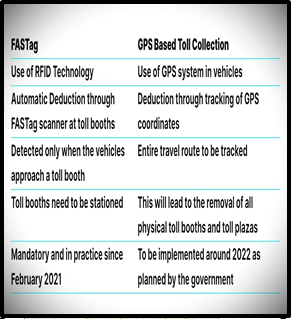
About “National Highways Authority of India.”:
- Role: Develops, maintains, and manages National Highways.
- Statutory Body: Under Ministry of Road Transport and Highways.
- Establishment: Constituted under NHAI Act, 1998; operational since February 1995.
- Composition: Full-time Chairman, up to five full-time Members, four part-time Members appointed by the Central Government.
- Wings: Technical, Finance, Administrative, and Vigilance at Headquarters.
Understanding the “Global Navigation Satellite System”:
The performance of GNSS is based on 4 criteria:
Associated Article: https://universalinstitutions.com/introducing-a-new-toll-collection-system/ https://universalinstitutions.com/understanding-how-global-positioning-system-gps-works/ |