
ISRO to Launch EOS-09, Boosts Lunar Ties
ISRO to Launch EOS-09, Boosts Lunar Ties
Why in the News ?
ISRO is preparing to launch the PSLV-C61/EOS-09 earth observation satellite on May 19. Concurrently, ISRO and JAXA held a technical meeting in Bengaluru to advance the Chandrayaan-5/LUPEX mission aimed at exploring the lunar south pole.
About PSLV-C61 and EOS-09 Launch :
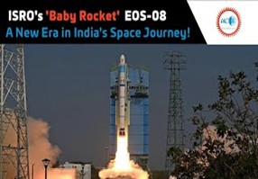
- ISRO’s 101st launch involves the PSLV-C61 rocket carrying EOS-09, an earth observation satellite.
- Launch scheduled for 5:59 a.m. on May 19 from Sriharikota’s Satish Dhawan Space Centre.
- EOS-09 uses C-band synthetic aperture radar, offering high-resolution imaging of Earth’s surface.
-
Designed for all-weather, day-night surveillance, enhancing India’s strategic observation capabilities.
Indo-Japan Collaboration on Chandrayaan-5:
- ISRO and JAXA held the 3rd Technical Interface Meeting (TIM-3) on May 13–14 in Bengaluru.
- Discussed the Chandrayaan-5/LUPEX mission, focusing on the exploration of lunar volatiles, especially water near the south pole.
- JAXA will launch the mission using its H3-24L
-
The ISRO-developed lunar lander will carry a Mitsubishi Heavy Industries (MHI)-built rover.
Global Scientific Collaboration and Significance
- ISRO, JAXA, ESA, and NASA will contribute scientific instruments.
- Instruments will aid in in-situ analysis of volatiles in the Permanently Shadowed Regions (PSRs) of the Moon.
- Builds on legacy of Chandrayaan missions 1–4.
- Marks India’s deepening role in international space cooperation and planetary science.
EOS-09 (RISAT-1B): Key Highlights● Purpose: Enhances India’s all-weather, day-night surveillance capabilities for border and coastal security. ● Launch: Scheduled for May 18 via PSLV-C61 from Sriharikota. ● Radar Advantage: Equipped with C-band Synthetic Aperture Radar (SAR), capturing images through clouds, fog, and darkness. ● Superiority: Unlike optical satellites, it ensures uninterrupted monitoring during monsoons or nighttime. ● Target Areas: Critical for India’s borders with Pakistan and China and the coastline. ● Dual Use: Aids agriculture, disaster response, forestry, and geological studies. ● Satellite Series: Follows RISAT-1, complements RISAT-2B, Cartosat, and Resourcesat. ● Past Role: RISAT aided in 2016 surgical strikes and 2019 Balakot airstrike. |


