
Impact of Chinese Dams on Brahmaputra River Flow
Impact of Chinese Dams on Brahmaputra River Flow
Why in the News?
Concerns have resurfaced over China’s proposed Medog hydropower project near the Great Bend of the Brahmaputra river system. This massive Brahmaputra dam China project has reignited discussions about water security and transboundary rivers between China and India. Amid fears of reduced downstream flow, experts emphasize that India contributes over 80% of the river’s yield due to monsoon and tributaries. This mega dam project, also known as the Medog Hydropower Station, has potential impacts extending to Bangladesh and could affect the entire Ganga river system, which is interconnected with the Brahmaputra. The Assam Chief Minister has expressed deep concern over the project’s potential impact on the state’s water resources and ecology.
Hydrology and Chinese Interventions:
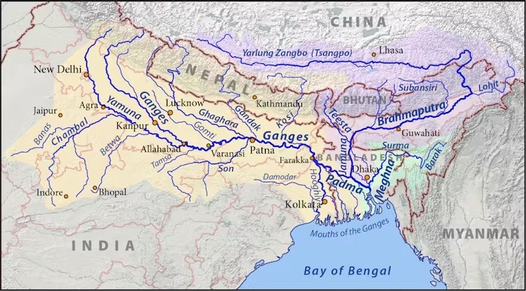
- The Brahmaputra originates in Tibet as Yarlung Tsangpo, also known as the Tsangpo river, and enters India through Arunachal Pradesh.
- Despite its Tibetan origin, 80% of river’s water yield is generated in India, mostly due to monsoon rains and tributaries of Brahmaputra.
- China’s existing hydroelectric dams on the China river portion, such as the Zangmu dam, are mostly run-of-the-river with minimal storage, posing limited downstream impact.
- Key concern: the 60,000 MW Medog Dam, which could be the world’s largest hydropower project and potentially the highest dam in Asia. The Power Construction Corporation of China is likely to be involved in this massive undertaking, which dwarfs even the famous Three Gorges Dam on the Yangtze River. This Brahmaputra dam China project is reminiscent of the scale seen in projects like those on the Yangtze River in India’s neighboring country.
- No official data suggests major water diversion or large storage affecting India, but the project raises concerns about ecosystem disruption and sediment flow. The scale of this China dam on the Brahmaputra far surpasses previous projects, leading to speculation about its potential impact on the river system and Indian cities on river banks.
Risks, Mitigation and Domestic Challenges
- Reduced flow risks are seasonal, especially during lean periods or peak power generation from the Brahmaputra dam China.
- India must develop reservoirs downstream to manage flow variability and mitigate flooding. The proposed Upper Siang Project in Arunachal Pradesh could play a crucial role in this strategy, similar to how the Farakka dam regulates flow in the Ganga system.
- Risks include dam failures, landslides, and earthquakes that can alter river flow suddenly, particularly given the seismic risks in the Himalayan bioregion.
- River morphology and ecosystems could be altered by upstream interventions, affecting the entire Brahmaputra river system, with potential impacts on fisheries and biodiversity. The fisheries impact could be significant, affecting both local communities and the broader ecosystem, including Indian cities on river banks along the Brahmaputra.
India’s Water Use and Strategic Response
- The Brahmaputra basin carries 30% of India’s water and 41% of hydropower potential.
- Usage is limited due to land acquisition issues and environmental concerns.
- Two proposed interlinking projects (Manas-Sankosh-Teesta-Ganga Link & Jogighopa-Teesta-Farakka Link) aim to transfer surplus water and address water management challenges in the region. These projects could be seen as India’s response to China’s South-North Water Diversion project.
- India needs scientific impact studies, hydrological data sharing protocols with China, and diplomatic engagement for disaster preparedness and to address geopolitical tensions surrounding water-sharing agreements, especially considering the interests of downstream nations like Bangladesh. The Assam Chief Minister has called for a comprehensive national strategy to address these concerns.
Key points about the Brahmaputra River:
- The Brahmaputra originates as the Siang (Dihang) from the Chemayungdung glacier in the Kailash range near Mansarovar Lake in the Tibet Autonomous Region.
- It enters India near Sadiya town in Arunachal Pradesh.
- Major tributaries include Dibang, Lohit, Siang, Burhi Dihing, Tista, and Dhansari.
- It is a perennial river with unique features due to its geography and climate.
- The river floods twice annually: once from Himalayan snowmelt in summer and again during the monsoon.
- Flood frequency and severity have increased due to climate change, impacting flow patterns and potentially exacerbating drought risks.
- These floods threaten population safety and food security in lower riparian states of India and Bangladesh.
- The river is dynamic, frequently changing course due to landslides and geological activity, which could be further impacted by the construction of mega dams like the Brahmaputra dam China.
The ongoing developments in the Brahmaputra river system highlight the complex interplay between hydroelectric dam projects, water security, and China-India relations. As both nations grapple with the challenges of managing this vital transboundary river, the need for collaborative approaches to flood mitigation, glacial melt monitoring, and sustainable water management becomes increasingly apparent. The potential impacts on Bangladesh further underscore the regional importance of these issues, necessitating a comprehensive approach that considers the entire river system from Tibet to the Bay of Bengal.
The Brahmaputra Express, a train that runs along parts of the river, serves as a cultural icon and a reminder of the river’s importance to the region’s transportation and economy. As discussions continue about the Brahmaputra dam China project, policymakers must consider not only the environmental and geopolitical implications but also the cultural significance of the river to the people living along its banks.


