IIT-DELHI’S HI-RES LANDSLIDE RISK MAP FOR INDIA
Focus:
In response to the 2023 North India floods and landslides, IIT-Delhi aimed to create India’s first national-scale landslide susceptibility map.
About the Landslide Map:
- Data Collection: Graduate student Nirdesh Sharma collected data on 1.5 lakh landslide events from sources including the Geological Survey of India.
- Factors considered : 16 factors influencing landslide susceptibility, like soil cover, tree density,etc
- High-Resolution Map: A high-resolution ‘Indian Landslide Susceptibility Map’ was developed with a 100m resolution, covering the entire nation.
Source: Springer
 Source: Springer
- Contribution :
- The map is hailed as an excellent contribution, providing the first comprehensive national-scale landslide probabilities.
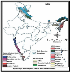
- Identified vulnerable regions include parts of the Himalayan foothills, Assam-Meghalaya, Western Ghats, and previously unknown risk areas.
- Ensemble machine learning methods.
- Future Initiatives:
- Plans to develop a ‘Landslide Early Warning System’ using map data.
- Beneficial for organizations like Geological Survey of India and National Disaster Management Authority
- Accessibility: The map, available online for free, offers public-friendly exploration through a user interface.