HUNDREDS SHELTERED AFTER MOUNT KANLAON ERUPTION IN THE PHILIPPINES
Why in the news?
- Mount Kanlaon, located on Negros island in the central Philippines, erupted on 3 June.
- The eruption lasted six minutes, projecting ash, rocks, and gasses up to 5 kilometers into the atmosphere.
- At least 2,800 people have been displaced due to the eruption,the state volcanology agency has warned that further eruptions are possible.
About Mt. Kanlaon:
- Kanlaon is the highest peak in Central Visayas, popular for trekking.
- Active andesitic stratovolcano with a peak elevation of 2,465 m (8,087 ft).
- Located on Negros Island, spanning Negros Occidental and Negros Oriental.
- Known for an active Lugud crater and seasonal Margaja Valley crater lake.
- Features hot springs: Mambukal, Bucalan, and Bungol.
- Most active Visayan volcano with 30 eruptions since 1819, monitored by PHIVOLCS.
 source:wordpress
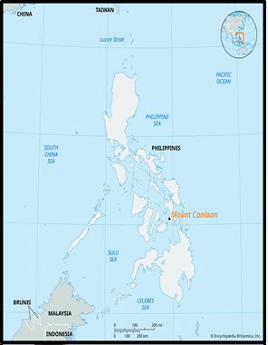
| About Negros Island:
Location and Geography:
Physical Features:
Notable Areas:
Associated Article: https://universalinstitutions.com/mount-ibu-erupts-massive-ash-tower-in-eastern-indonesia/ |