HOW CAN WAYANAD REDUCE LANDSLIDE RISKS?
Syllabus:
- GS 1: Physical Geography
- GS 3: Disaster Management
Why in the News?
Massive landslides in Wayanad, Kerala, triggered by continuous torrential rainfall on July 30, caused widespread destruction and a death toll of 215. Human activities and natural factors contributed to the disaster, highlighting the need for better land management and warning systems.
 Source: India Today
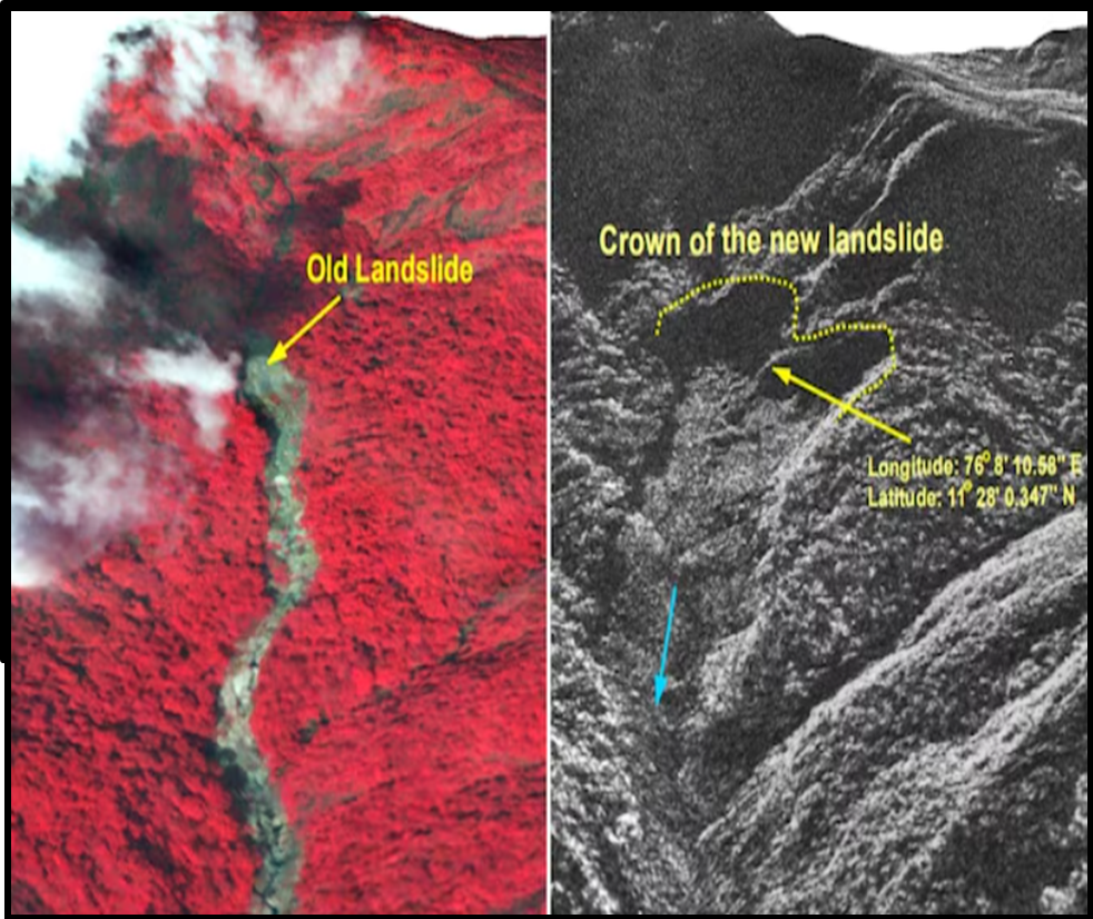
Introduction
- Massive landslides devastated Wayanad in northern Kerala on July 30, causing extensive death and destruction.
Why did this happen?
- Heavy rainfall and the steep slopes of the Western Ghats made the region vulnerable.
What role did human activities play?
- Increased construction, tourism, and changing crop patterns exacerbated the disaster, raising questions about sustainable development and preparedness.
Landslides
Types of Landslides
Causes Natural
Human-Induced
|
Causes of Landslides in Wayanad
Natural Factors
Geological Susceptibility
- Kerala’s Terrain: Nearly half of Kerala’s land area, amounting to 19,301 sq. km or 49.7% of the total landmass, is prone to landslides, according to the Geological Survey of India (GSI).
- Western Ghats Slope: The slope of the Western Ghats significantly increases Wayanad’s vulnerability to landslides.
Heavy Rainfall
- Rainfall Patterns: Wayanad experiences heavy rainfall, making it uniquely vulnerable. According to research at IIT-Delhi, 31.54% of the district is highly susceptible to landslides.
- Climate Change Impact: Climate change has altered rainfall patterns in Kerala.
- The warming of the Arabian Sea contributes to the formation of deep cloud systems, resulting in extremely heavy rainfall over shorter periods.
- Recent Trends: Recent years have seen an increase in heavy rainfall events, even as the number of rainy days during the monsoon season has decreased.
Human Factors
Construction and Development
- Tourism Boom: Wayanad has become a popular tourist destination, with an increase in homestays and monsoon tourism.
- Inappropriate Development: Ecologist Madhav Gadgil highlights that construction of resorts, artificial lakes, and the presence of abandoned quarries in sensitive zones have exacerbated the risk of landslides.
Land Use Changes
- Historical Land Use: Land use changes date back to the British era, starting with the establishment of tea plantations surrounding the disaster site.
- Post-Independence Developments: These land use changes have continued in the post-Independence era, contributing to the current susceptibility to landslides.
- Impact on Forest Cover: A study published in the International Journal of Environmental Research and Public Health in 2022 found a 62% reduction in forest cover between 1950 and 2018, along with an 1,800% increase in plantation area.
- Monocropping Effects: Monocropping practices have led to the loosening of topsoil, which was previously held in place by forest roots.
Climate Change
Rainfall Pattern Changes
- Deep Cloud Systems: The warming of the Arabian Sea allows for the formation of deep cloud systems, leading to heavy rainfall in shorter durations.
- Seasonal Variations: Wayanad has witnessed a shift from a cool, humid environment with consistent drizzles to one with drier, hotter summers and intense monsoon downpours.
- Impact on Soil: Dry soils absorb less water, and heavy rainfalls cause run-offs, increasing the risk of landslides.
- Rainfall Data: Despite recording 527 mm of rainfall in Mundakkai over 48 hours before a recent landslide, Wayanad has seen only normal rainfall averages this monsoon.
- In contrast, Kerala as a whole has experienced rainfall deficits.
Scientific Insights
Mariam Zachariah’s Observations
- A researcher at the Grantham Institute for Climate Change, Mariam Zachariah notes that the changes in climate have increased the risk of landslides.
- The transformation of the environment from a cool, humid one to drier, hotter conditions with intense monsoon rains has contributed significantly to the occurrence of landslides
Protecting the Western Ghats
Gadgil Report Recommendations
- Led by Mr. Madhav Gadgil, the Western Ghats Ecology Expert Panel proposed a comprehensive protection plan in 2011.
Ecologically Sensitive Zones (ESZ)
- The report suggested designating the entire Western Ghats (1,29,000 sq km across six states) as an ESZ.
Classified into 3 Zones
- ESZ 1: Strict restrictions on development, including:
- Land Use: Ban on changes.
- Mining and Quarrying:
- Hydropower Projects:
- Infrastructure: No new railway lines or major roads.
- Ecotourism: Regulated and minimal.
- ESZ 2 & ESZ 3: Less restrictive but still regulated
- Wayanad: All taluks in Wayanad were categorized under ESZ 1, with Meppadi highlighted as a sensitive area.
Recommendations Rejected
- State governments rejected the report due to concerns about its impact on livelihoods and economic growth.
Kasturirangan Panel’s Modifications
- Revised Recommendations: A subsequent panel led by K. Kasturirangan proposed protecting only 37% of the Western Ghats.
- Wayanad Protection: Despite the revisions, much of Wayanad remained under protection.
- Implementation Issues: The revised report was not implemented.
Current Status
- Draft Notification: A draft notification for Western Ghats protection has been pending since March 2014, with its sixth version released just after the Wayanad landslide.
- Committee Review: A 2022 committee was formed to address state concerns and balance conservation with developmental needs. The committee’s report is still awaited.
Landslide Warnings Issued
IMD Warnings
- Colour-Coded System: The Indian Meteorological Department (IMD) issues warnings using a colour-coded system for rainfall.
- Pre-Landslide Alerts: In the week before the landslides, warnings were mostly yellow, indicating caution but not requiring action.
- Post-Landslide Alert: A red alert was issued only after the landslide on July 30.
GSI Early Warning System
- Current Status: The Geological Survey of India (GSI) is developing an early warning system for landslides.
- Timeline: The system is still experimental and is expected to be ready in four to five years.
- Regional Forecasts: Since the start of the 2024 monsoon, Wayanad authorities received bulletins predicting “low” to “moderate” landslide risk, with higher risk noted on July 30.
Conclusion
To mitigate landslide risks in Wayanad, addressing both natural and human factors is crucial. Implementing stronger environmental protections, adhering to expert recommendations, and improving early warning systems are essential steps to prevent future disasters.
Source:The Hindu
Mains Practice Question:
Examine the natural and man-made factors that contributed to the recent large-scale landslides in Wayanad, Kerala.
Associated Article:
https://universalinstitutions.com/centre-reissues-western-ghats-esa-draft-notification/