GOVT LAUNCHES GEOSPATIAL DECISION SUPPORT SYSTEM FOR AGRICULTURE
Why in the news?
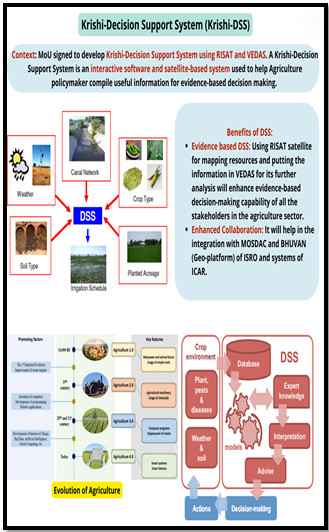
In order to aid in agricultural decision-making, the Indian government introduced the Krishi Decision Support System (K-DSS), a geospatial platform intended to act as a repository of standardized data, including weather, soil, crops, reservoirs, and groundwater information.
Key Details
- K-DSS, or the Krishi Decision Support System: K-DSS is a component of the effort called Digital Public Infrastructure (DPI) for Agriculture, which intends to develop cutting-edge digital services focused on farms. The platform combines different kinds of data to give farmers and decision-makers all-encompassing assistance.
- Launch Specifics: During the “National Conference on Space Driven Solutions for Agriculture Transformation in India,” Union Minister of State for Agriculture and Farmers Welfare formally launched the K-DSS portal.
- DPI for Agriculture: Introduced in the Union Budget 2023–24, the DPI for Agriculture is a comprehensive plan to employ digital technologies to increase farming’s sustainability and efficiency.
- Space Applications Centre (SAC):
- Located near Ahmedabad, SAC is a significant ISRO research and development facility.
- It contributes to the advancement of space technology and its uses in a range of industries, including agriculture.
- The Function of ISRO: The Indian Space Research Organisation (ISRO) has played a pivotal role in the development and deployment of satellites that furnish vital data for agricultural purposes, including but not limited to crop health monitoring, weather pattern prediction, and water resource management.
Global Navigation Satellite System (GNSS)
|


