FARM FIRE COUNTING: UNDERSTANDING THE PROCESS
Why in the News?
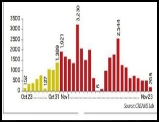
- Between September 15 and November 23, a total of 55,725 farm fires were recorded across six North Indian states – Punjab, Haryana, Uttar Pradesh, Delhi, Rajasthan, and Madhya Pradesh.
- Punjab alone accounted for 36,323 fires during this period.
Farm fires in PunjabSource: The Indian Express
 Source: The Indian Express
Data Collection Agency
- The data is collected by the Indian Agricultural Research Institute’s (IARI) Consortium for Research on Agroecosystem Monitoring and Modeling from Space (CREAMS) Laboratory.
- CREAMS provides daily bulletins, offering a district-wise breakdown, location details, satellite information, time of recording, and fire intensity.
Satellite Monitoring
- Three sensors on NASA satellites – VIIRS on Suomi NPP, and MODIS on Terra and Aqua – collect data by recording land surface temperatures.
- Satellites pass over the Indian subcontinent twice daily, capturing the region from the Indian Ocean to Ladakh.
Additional Satellite for Mapping
- Sentinel-2 satellites, owned by the European Space Agency, are used for mapping burnt areas at the end of the season, providing insights into the planted and burnt areas.
Monitoring Protocols
- The Commission for Air Quality Management (CAQM) introduced a standard protocol in 2021 for consistent monitoring of farm fires using satellite data.
- Protocols ensure uniformity in reporting, avoiding discrepancies observed in previous years.
Identification of Paddy Fires
- Differentiating paddy crop residue fires from other sources involves identifying paddy cultivation areas.
- Paddy’s unique reflectance signature and its distinct features, like a background of water, help in accurate identification.
Recording Fire Intensity
- Fire intensity, expressed as energy emitted per unit area and time, indicates the amount of residue burnt.
- Intensity recordings aid in understanding the scale of burning, helping authorities make informed decisions.
Bulletin Dissemination
- The daily bulletin is shared with central and state-level agencies, including CAQM, Ministry of Agriculture, and state agriculture departments.
- Authorities utilize the data to implement targeted measures in districts with significant hotspots.
Limitations
- The number of operational satellites influences data frequency; more satellites allow capturing events more frequently.
- Climatic conditions, such as cloud cover, affect satellite readings, and recalibration may be required in certain situations.
- Private sector advancements in satellite constellations could enhance data availability in the future.