China’s Yarlung Tsangpo Dam: India’s Growing Concerns
Why in the news?
China has approved the world’s largest hydropower project on the Yarlung Tsangpo River. India raises concerns about the impact on water flow, ecology, and regional stability, urging transparency and cooperation from China.
Overview of the Yarlung Tsangpo Dam Project:
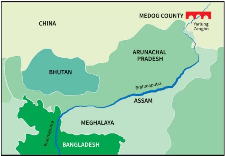
- On December 25, China approved the construction of the world’s largest hydropower project on the Yarlung Tsangpo (Zangbo) River in Tibet.
- The 60,000 MW dam is set to produce three times the electricity of the Three Gorges Dam.
- The Yarlung Tsangpo enters India through Arunachal Pradesh (known as the Siang) and continues to Assam before flowing into Bangladesh and the Bay of Bengal.
China’s Objectives for the Project:
- The project is part of China’s plan to move away from conventional energy sources and achieve carbon neutrality by 2050.
- The Yarlung Tsangpo is ideal for hydropower due to its steep descent and high water flow.
- Concerns about the environmental impact of China’s extensive dam network, including possible earthquakes, water displacement, and ecological damage.
India’s Concerns and Options:
- India, a downstream nation, fears that the dam could disrupt water flow, affecting agriculture, biodiversity, and the river’s silt flow.
- The region is earthquake-prone, which increases risks of disasters.
- India has raised concerns about such projects through diplomatic channels, but China has largely been uncooperative regarding data sharing.
- Experts suggest India should challenge China’s claims and ensure a clear understanding of the dam’s potential downstream impacts to avoid future conflicts.
Key Facts about Brahmaputra River:
- Origin: The Brahmaputra originates as the Siang/Dihang River from the Chemayungdung glacier in the Kailash range near Mansarovar Lake.
- Flow: Enters India in Arunachal Pradesh, flows through Assam, Meghalaya, Nagaland, West Bengal, and Sikkim.
- Tributaries: Left bank – Dibang, Lohit, Burhi Dihang, Dhansari. Right bank – Subansari, Kameng, Manas, Sankosh, Kelang.
- Geography: Carves the deepest canyon on Earth, with a vertical difference of 25,154 feet.
- Confluence in Bangladesh: Joins Teesta (Jumna), which merges with the Padma and then the Meghna, flowing into the Bay of Bengal.
Sources Referred:
PIB, The Hindu, Indian Express, Hindustan Times


