China Pokes India For Arunachal Pradesh
Relevance
- GS Paper- 2 Bilateral Ties
- Preliminary Test- India- China Map, South China Sea
Tags: #upsc #ArunachalPradesh #mapofchina #southchinasea.
Why in the News?
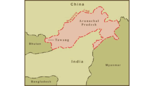
- China’s Ministry of Natural Resources released a ‘standard map of China’, including the part of Arunachal Pradesh and Aksai Chin as parts of the East Asian nation.
- Taiwan and the disputed South China Sea have also been included within ‘Chinese territory’ on the map.
- The map released on August 28 shows Arunachal Pradesh which China claims as South Tibet and Aksai China occupied it in the 1962 war as part of its territory.
India-China Turmoil
India and China have been in a standoff situation for the last three years and relations at all levels have deteriorated due to tensions on the line of actual control (LAC). The two sides have held 19 rounds of talks so far to address the boundary issues in eastern Ladakh since 2020.
India’s response
- The external affairs ministry spokesperson Arindam Bagchi had said- that Arunachal Pradesh is, has been, and will always be an integral and inalienable part of India. Attempting to assign invented names will not alter reality.
- The Congress on Tuesday said these (Arunachal Pradesh) are inalienable parts of India which no such illegal representation or arbitrarily invented map by the “habitual offender” can change.
Points To Remember
- India-China Map
- South China Sea
- Aksai Chin
- Line of Actual Control