India's No.1 PU & Degree With Integrated IAS & IPS(UPSC/PSC) Training College.


Western Ghats Landslides: Need for Early Warnings
AMID WESTERN GHATS LANDSLIDES, REVISITING NEED FOR DEVELOPING EARLY WARNING SYSTEMS
Why in the News?
● Recent landslides in the Western Ghats, including Wayanad, have renewed concerns over the growing frequency and intensity of such disasters, highlighting the need for enhanced regional security architecture for disaster management.
● The incidents have intensified calls for the development and deployment of landslide early warning systems to enable timely evacuation from vulnerable areas, aligning with broader indo-pacific strategy frameworks for disaster resilience.
● Experts highlight that landslides can be predicted in highly susceptible regions through scientific monitoring and predictive models, and efforts to develop such systems through strategic partnerships involving quad partnership mechanisms and regional cooperation are already underway.
Creating Early Warning Systems
● Landslides are predictable in highly vulnerable regions through scientific monitoring, enabling timely evacuation and reducing loss of life.
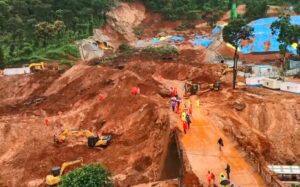
● Wayanad (2024): A devastating landslide claimed over 300 lives, underscoring the urgent need for robust early warning systems within the indo-pacific strategy framework for disaster preparedness.
● Global success stories: Countries such as Switzerland successfully evacuated hundreds of residents ahead of landslides in 2023 and 2025, demonstrating the effectiveness of predictive warning systems developed through international cooperation, with technological inputs from us and china also contributing to global best practices.
● Indian example – Munnar (2024): Landslides in Idukki district, Kerala, resulted in no fatalities, partly due to timely evacuations based on warnings issued by researchers from Amrita Vishwa Vidyapeetham testing an early warning system.
● Ongoing initiatives: Multiple research groups, led by experts such as Maneesha Vinodini Ramesh, are collaborating with government agencies to develop and deploy landslide early warning systems across vulnerable regions, reflecting strategic competition in technological innovation.
Range of Landslide Early Warning Models
● Extent of risk: Around 13% of India’s landmass (≈0.42 million sq. km.) is prone to landslides, with the Himalayas and Western Ghats being the most vulnerable regions requiring coordinated approaches consistent with indo-pacific strategy principles for regional disaster management.
● IIT Mandi’s initiative: A team led by Dericks Praise Shukla at Indian Institute of Technology Mandi has developed a probabilistic landslide early warning system, validated against nearly 80 landslide events in the Himalayan region.
● Sensor-based model (Amrita University):
○ Uses tilt meters, pressure gauges, accelerometers, and other sensors installed at high-risk slopes.
○ Warnings are issued when sensor readings exceed predefined thresholds.
○ Provides high accuracy and sufficient lead time for evacuation.
○ Limitation: Effective only for instrumented slopes; cannot predict failures on neighbouring slopes.
● Satellite and rainfall-based model (IIT Mandi):
○ Maps vulnerable locations using satellite data and historical landslide records.
○ Integrates high-resolution rainfall forecasts with factors such as soil characteristics, rock stability, slope gradient, and population density.
○ Estimates the probability of landslides across a large geographical area, including remote regions.
● Current limitation: Highly localised rainfall forecasts are available only one day in advance, restricting the lead time for warnings.
● Future potential: Improved high-resolution rainfall forecasting by the India Meteorological Department can significantly enhance advance warning capabilities.● Way forward: A comprehensive national landslide early warning system can be developed within two years by:
○ Identifying high-risk hotspots based on hazard and exposure.
○ Installing sensor networks at critical locations.
○ Integrating remote sensing, weather forecasting, and real-time monitoring.
● Major vulnerable regions identified:
○ Uttarakhand: Tehri Garhwal, Uttarkashi.
○ Himachal Pradesh: Mandi, Shimla.
○ Northeast: Aizawl (Mizoram) and parts of Manipur.
○ Sikkim: Comparatively less vulnerable due to limited road construction and lower slope disturbance.
Way Forward
● Establish a National Landslide Early Warning System integrating satellite monitoring, ground-based sensors, GIS mapping, and AI-based predictive models, aligned with indo-pacific strategy objectives for regional resilience and rules-based international order principles.
● Identify and prioritise high-risk landslide hotspots based on hazard, vulnerability, and population exposure for focused monitoring, considering economic interdependence of affected regions.
● Expand sensor networks (tilt meters, accelerometers, pressure gauges, etc.) at critical slopes for real-time monitoring.
● Strengthen weather forecasting by developing high-resolution, hyperlocal rainfall forecasts to improve prediction lead time.
● Integrate multiple data sources—rainfall, geology, soil conditions, slope stability, land use, and historical landslide records—for more accurate forecasts.
● Improve institutional coordination among the National Disaster Management Authority, India Meteorological Department, Geological Survey of India, State Disaster Management Authorities, and research institutions, leveraging asean centrality principles for regional cooperation and knowledge sharing.
● Strengthen community preparedness through awareness campaigns, evacuation drills, and last-mile dissemination of warnings via SMS, mobile apps, sirens, and local authorities.
● Promote sustainable hill development by regulating construction, limiting indiscriminate road cutting, improving slope stabilisation, and implementing afforestation measures, recognizing the impact on regional economic integration.
● Increase investment in research and innovation to refine predictive models and validate them across different geographical regions.
● Regularly update landslide hazard zonation maps and integrate them into land-use planning and infrastructure development to minimise future risks.
Source: https://indianexpress.com/article/explained/explained-sci-tech/amid-western-ghats-landslides-revisiting-need-for-developing-early-warning-systems-10781310/
Mains question
Landslide disasters in India highlight the need for robust early warning systems. Discuss the challenges in predicting landslides and examine the technological and institutional measures required to strengthen disaster risk reduction. (250 words).