DIGITAL PLATFORM AND DRONES BOOST SOLAR POWER
Why in the news?
The use of drone technology and a digital platform is revitalising the PM-KUSUM solar power scheme, overcoming land issues, and significantly advancing solar installations in Rajasthan.
source:scribd
Digital Platform Revives Solar Power Scheme with Drones:
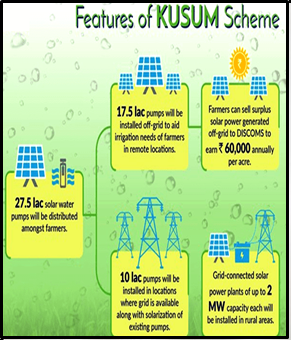
- PM-KUSUM Programme: Aims to set up 100 GW of solar power, install4 million solar pumps, and solarise 3.5 million grid-connected pumps on farmland.
- Current Status: By June, only 256 MW of power plants, 397,000 solar pumps, and 13,500 solarised pumps had been installed. The deadline has been extended to
- Challenges: Key issues include a shortage of suitable land and difficulties in pooling enough land for solar projects. The programme has faced delays and low adoption rates.
Drone Technology and Digital Platform
- Digital Platform: Developed in collaboration with the Rajasthan government, this platform uses drone technology to map land parcels for solar power projects.
- Implementation: The platform facilitates real-time tracking, oversight, and prompt corrective actions. It has already led to the installation of 3 MW in Rajasthan, with a target of 100 MW by 2024.
- Expansion: Plans to apply the same approach in Maharashtra and Madhya Pradesh are underway.
About High Altitude Pseudo-Satellite (HAPS):
Key Benefits:
Applications:
Comparison with Satellites and Drones:
India’s Progress:
Associated Article: https://universalinstitutions.com/meet-haps-indias-very-own-uav/ |


