UNDERSTANDING HOW GLOBAL POSITIONING SYSTEM (GPS) WORKS
Evolution of GPS:
- Initiated by the U.S. Department of Defense in 1973, the Global Positioning System (GPS) revolutionized various sectors.
- First satellite launched in 1978, comprising a constellation of 24 satellites orbiting the Earth in six orbits.
GPS Components:
Space Segment: Constellation of 24 satellites, ensuring at least four visible satellites from any point on Earth. Orbits at 20,200 km above Earth.
Control Segment: Network of ground-based control stations and antennae globally tracking and controlling satellite performance.
User Segment: Utilization of GPS across sectors like agriculture, construction, logistics, and more.
In 2021, an estimated 6.5 billion Global Navigation Satellite System (GNSS) devices were in use, projected to reach 10 billion by 2031.
GPS Working Mechanism:
- Each satellite broadcasts a radio signal containing location, operational status, and emitted time.
- Receivers on Earth calculate precise distances using signal travel time, enabling accurate triangulation of location.
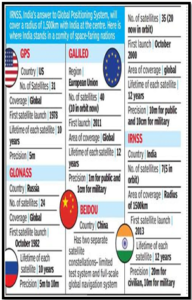
Global Navigation Satellite Systems (GNSS):
- Cooperation among various GNSS, including Russia’s GLONASS, the EU’s Galileo, and China’s BeiDou.
- International Committee on GNSS ensures compatibility and cooperation among global systems.
Source: ToI
 Source: ToI
India’s Contribution:
- (NavIC) system: India’s Navigation with Indian Constellation (NavIC) system, consisting of seven satellites, facilitates ground-based navigation.
- (GAGAN) system:Operation of the GPS-Aided Geo Augmented Navigation (GAGAN) system, developed by ISRO and the Airports Authority of India, enhances safety in civil aviation.
Uses Of Navigation and positioning System:
- Agriculture: Geo-Mapping of fields.
- Surveying and Mapping: Accurate geographic data.
- Logistics: Real-time shipment tracking.
- Search and Rescue: Rapid location identification.
- Air Travel: Enhanced aviation safety.
- Meteorology: Weather forecasting.
- Seismology: Earthquake monitoring.
- Military: Navigation and precision.
- Time Sync: Accurate timekeeping across time zones.
- Location-Based Services: Smartphone geotagging.
GPS, a pivotal technology, has transformed how we perceive location across diverse sectors globally.